
-
 2515 Hits
-
 79.04% Score
-
 10 Votes
|
|
Mountain/Rock |
|---|---|
|
|
42.92988°N / 0.02090°E |
|
|
Hiking, Skiing |
|
|
Spring, Summer, Fall |
|
|
8081 ft / 2463 m |
|
|
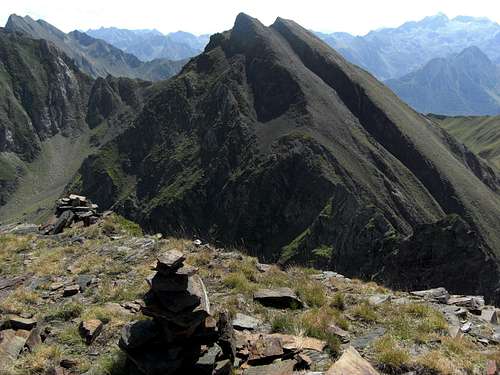
Overview
 Pic de Léviste and neighbouring summits
The first prominent mountain ridge between the valleys of Argelès-Gazost and Bagnères de Bigorre is that of Pic du Midi de Bigorre. This huge mountain dominates all the views from the Tarbes plain. To the west, Pic du Midi de Bigorre stretches a long and dendritic ridge with many summits and subridges, which are 300 to 400 meters lower than Pic du Midi thus emphasizing its emersed position.
One of these lower summits is Pic de Léviste. This peak is near the western end of the main ridge high above the village of Pierrefitte-Nestalas. Its position between the equally high summits of Soum de Léviste to the west and Soum Arrouy to the east causes a rather hidden aspect of Pic de Léviste; in fact you always have to search a while in order to identify our “Pic” when looking for it from another Bigorre summit.
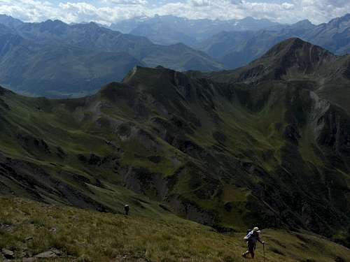
Pic de Léviste is situated between the Vallée d`Isaby and the Hautacam ski area to the north and the valley which stretches from Luz Saint Sauveur to the famous Col du Tourmalet, one of the challenges of the Tour de France. There are several possibilities to summit this mountain from the north, the northeast, the northwest and the south. The scenery is always great: huge cirques with steep meadows, rock peaks and ridges and great views to the south, west and north. Only to the east Pic du Midi is blocking your view a bit.
Pic de Léviste was the ideal starter for my 2011 Pyrenean hiking weeks. Like the neighbouring Soum Arrouy or Soum de Lascours, which can be recommended equally as an interesting hiking aim, Pic de Léviste gives you a good look on Pyrenean – Bigorre hiking condition: narrow trails, mainly unmarked or only sparsely cairned, in parts off-trail, deeply cut-in valleys, soaring vultures, sparkling creeks, deep blue mountain lakes, remote landscape, interesting wildflowers and the possibility to summit a neighbouring peak, if – yes – if not a sudden appearance of dense fog and heap clouds reduce your sight to nearly zero ………….
Getting There
 Pic de Léviste as seen from Val d´Azun
Pic de Léviste is situated between the Argelès-Gazost – and the Bagnères-de-Bigorre valley.
Trailheads near Argelès-Gazost
Southern trailhead
Trailhead near Bagnères-de-Bigorre
Route Overview
The following names of the trails are no official denominations. They are my invention and correspond to the trailheads.Hautacam trail
From Col de Tramassel follow the dirt road to Col de Moulata up to the first col between Pic de Moulata and Pic de Nerbiou. Leave the dirt road at that col on narrow trails traversing level the south slopes of Pic Moulata and Pic Naouit, passing by Lac de Layous. After a while you reach the slightly descending trail coming from the parking area of Col de Moulata. Proceed on the different trails to the Picourlet hut, thus passing by high above beautiful Lac d´Isaby to the Lac dets Plagnous or descend to Lac d´Isaby and traverse the contributing creeks to the south. Climb the north slopes on a narrow trail and then off-trail to Lac dets Plagnous where you meet again the first trail.
Climb steeply up to the meadow cirque of Grand Estibère. Leave the trail, which proceeds to Soum Lascours, to gain the little stone hut in the middle of the cirque. Proceed on some narrow trails to the south until you reach the bottom of the little cirque northeast of Soum Arrouy summit. Go to Point 2216 m of the IGN maps and enter the northwestern cirque below Soum Arrouy summit. A narrow trail leads steeply up to the col between Soum Arrouy and Pic de Léviste. Climb the east ridge up to the summit.
 Pic de Léviste from near Col de Tramassel Pic de Léviste from near Col de Tramassel | 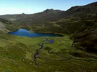 Lac d´Isaby Lac d´Isaby | 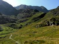 On the northern trail near Lac dets Plagnous On the northern trail near Lac dets Plagnous |
Ortiac trail
Follow the dirt road into Isaby valley to la Prade, to the Bois d´Isaby and to the lake, where you meet the Hautacam trail. Proceed on that trail as described above. Long trail with 1500 meters of altitude difference.
Sers trail
From Sers use the dirt road leading north into the valley coming down from Soum Lascours and Soum Arrouy. Follow the trails to Cabane d´Erès Lagues. Turn left (west) and climb off-trail the col between Soum Arrouy and Soum de Manaout. At the col follow the steep south ridge of Soum Arrouy to its summit.
There are two possibilities to gain Pic de Léviste summit.
These are also the variations to summit both peaks whatever trail you are using (!!):
1.) Follow off trail the west ridge to the col between Soum Arrouy and Pic de Léviste. There is some rock scramble involved (UIAA grade I to II). Don´t climb directly down to the col, stay a bit south of the ridge crest where the rocks are easier. There is a shallow and easy chute which leads down to easier terrain south of the col. Climb the east ridge to Pic de Léviste.
2.) Follow the east ridge of Soum Arrouy down to the first col. Descend steeply into the northeastern cirque below Soum Arrouy summit. Traverse the cirque and gain a narrow cairned trail which leads to the point 2242 m of the IGN maps and to the Hautacam / Ortiac / Lesponne trail. Go on as described above.
 Pic de Léviste Pic de Léviste |  On the northern trail, view to Mont Aigue On the northern trail, view to Mont Aigue |  Northeastern cirque below Soum Arrouy Northeastern cirque below Soum Arrouy |
Lesponne trail
At le Chiroulet follow the road and the trail to the west up to Hourquette d´Ouscouaou. At the Hourquette (col) follow one of the trails leading to the south and into Grande Estibère where you reach the Hautacam trail. Follow this trail as described above.
 Summit view to Néouvielle Summit view to Néouvielle |  Summit view to the west Summit view to the west | 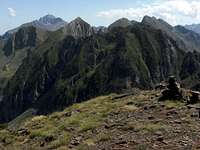 Summit view to the east - Pic du Midi Summit view to the east - Pic du Midi |
Red Tape & Accommodation
 Soum Arrouy from Léviste summit
Pic de Léviste is not within a Réserve Naturelle.
Nevertheless respect the wildflowers, animals and the grazing cattle.
Lac d´Isaby is a great place for backcountry camping.
Hotels, bed & breakfast, holyday houses and apartments, campgrounds can be found in every nearby village like
Argelès-Gazost
Pierrefitte-Nestalas
Luz Saint Sauveur
Bagnères de Bigorre
Gear & Mountain Condition
 Arriving at Pic de Léviste
Pic de Léviste is a hiking summit, mainly for late spring, summer and autumn.
You need normal hiking gear, good shoes and a knack for orientation and for off-trail walking. The direct traverse Pic de Léviste – Soum Arrouy needs a short climb of UIAA grade I and II in exposed terrain.
In my opinion the northern slopes from Lac d´Isaby to Pic de Léviste can be a nice ski tour, too. There is no ski route for this summit in the IGN maps. But with secure avalanche conditions and full ski tour and avalanche gear the north slopes of Pic de Léviste and Soum Lascous from Hautacam road via Grande Estibère can be a great ski adventure.
Current Weather:
avalanche bulletin of Hautes Pyrénées
Maps & Guide Book
 Soum Arrouy in clouds
Maps
Good overview:
IGN 1 : 50.000
Carte de Randonnées 1 : 50.000, number 4, Bigorre, IGN Rando Editions
Better for planning and orientation:
IGN 1 : 25.000
Number 1647 ET, Lourdes, Argelès-Gazost, Le Lavedan
Number 1747 ET, Bagnères-de-Bigorre, Pic du Midi de Bigorre, Vallée de Campan
Number 1748 OT, Gavarnie, Luz-Saint-Sauveur, Parc National des Pyrénées
Guide Book
If somebody knows good guide books with Pic de Léviste please add them to the “Additions & Correction” section, I will fill them into that page.