
|
|
Mountain/Rock |
|---|---|
|
|
47.68862°N / 18.87219°E |
|
|
Pest |
|
|
Hiking, Trad Climbing |
|
|
Spring, Summer, Fall, Winter |
|
|
2480 ft / 756 m |
|
|
Overview
Pilis is the highest mountain of Pilis Mountains, and the second highest of Hungary's Transdanubian region. It has the shape of a flatiron, with the "nose" pointing SE. Its highest point is called Pilis-tető (756 m), literally meaning "Pilis-roof". In fact, the top of the mountain is rather flattish, plateau-like. Its prominence from the surroundings is about 550 m. Arriving to Pilis-tető (winter photo)
 the lookout tower
For several decades, Pilis used to be a popular target for hikers. Then, in the 1970's an air defense base was built on it, and all trails that led to the top were ceased. Military presence lasted until 1996, when the base was dismantled (actually, not completely - the bunkers' remains can still be seen). Since its "liberation", hikers and paragliders returned to Pilis-tető, but officially it was still a not accessible area. This situation changed in the end of October 2014, when the former geodetic tower (which was closed to the public beforehand) was transformed to a lookout point, and a new trail was marked leading to it. From its roof deck, a very nice all-around panorama opens to the surounding mountains: in N direction, over the neighbouring Dobogókő (highest point of Visegrád Mts.) you can spot the massif of Börzsöny Mts., looking SE-S are standing the Buda Hills, while towards W the hills of Gerecse Mts. frame the view.
Apart from its height, Pilis is interesting for other features as well. Underneath the surface, several beautiful caves (most of them only accessible to cavers) hide within the Dachstein Limestone, which is the building material of the mountain. At various spots of the mountain's perimeter, this rock gets exposed to the surface. Among these rocky parts there are some notable ones, like Vaskapu (a scenic double arch) or the outcrop where the prehistoric cave dwelling (Szántói-kőfülke) is to be found.
 The twin arches of Vaskapu The twin arches of Vaskapu |
 The long-back mountain The long-back mountain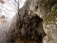 Szántói-kőfülke (cave) Szántói-kőfülke (cave) |
Getting There
 A couple of meters away from the parking place at Pilisszántó
 Fall colors near the Vaskapu
Two villages lie close to the feet of Pilis mountain: Pilisszentkereszt (Slovak: Mlynky) to the E, and Pilisszántó (Slovak: Santov) to the SE. Both can be easily accessed by regular buses from Budapest, which depart from the Árpád-híd (Árpád bridge) bus terminal. Pilisszentkereszt is easier to get to, as it's on the way to Dobogókő mountain resort, where buses are more frequent.
If you are coming by car from Budapest, leave the town northwards on road number 11 towards Szentendre. When you reach the edge of this town, take a left turn for Pomáz and follow the road signs towards Dobogókő. Take care for the bikers, there are many of them on this road. After about 11 km, you'll arrive to Pilisszentkereszt. About 1 km further, you'll reach a junction in the village, where you will find a road sign for Pilisszántó and Pilisvörösvár towards the left.
Pilisszántó can be approached from Budapest by an alternative route as well: take road no. 10 to Pilisvörösvár, and there look carefully for the road sign to Pilisszántó (in fact it can be a little tricky to find the right street for the first time). You can find suitable parking place at the northern end of the village, besides the road, near to the quarries.
Another option is to drive further up from Pilisszentkereszt towards Dobogókő, and leave the car at the junction where the road bifurcates for Esztergom and Dobogókő. This place is called Két-bükkfa-nyereg (Two Beech saddle), and there's a little parking place by the road. Here starts the asphalted service road created for the military base on Pilis-tető (now closed for motorized traffic). This place is also a good place to approach Vaskapu from.
Red Tape
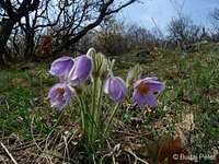 Greater pasque flower Greater pasque flower |
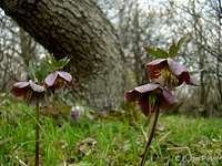 Purple hellebore Purple hellebore |
 Autumn crocus Autumn crocus |
Pilis is part of the Duna-Ipoly National Park. Visiting of the park is free of charge, but you should obey some important rules, especially if you're leaving the signed trails. Several rare and protected plants live here: Greater Pasque flower (Pulsatilla grandis), Purple hellebore (Helleborus purpurascens), Yellow pheasant's eye (Adonis vernalis), Snowdrops (Galanthus nivalis) etc. It is essential to take care and avoid disturbing their habitat, especially in the rocky areas.
One of the plants needs special attention. This is Ferula sadleriana, a very rare, strictly protected endemic species (having a symbolic value of 900€), whose largest contingent (making up about half of the entire wild population) can be found in the SE part of Pilis-tető. As the plant is not particularly attractive, it is not threatened by collection activities, but rather by grazing of wild animals and the trampling of humans who visit the area (this place is one of the best takeoff points for paragliders). If you'd like to enjoy the view, better choose the new lookout tower, and do not venture into the SE part of the plateau. It's less romantic, but environmentally more responsible.
Routes
 view from the SE ridge
The most scenic "legal" route is the panorama trail (marked with green stripe) that traverses the SE nose and the SW side of the mountain. This route offers a couple of nice lookout points along the way, and the new trail leading to the top (marked with green triangle) also branches off from this one (on a wide glade). Although there is an alternative path starting at the first lookout point (called "László kúpja"), featuring some nice rocks along the way, its upper section involves the habitat of Ferula sadleriana (see the Red Tape section), and thus, it is discouraged to take (neither are there any trail marks on this route).
Maps
 Twin rocks on the SE ridge
Paper maps
See the Parent page.
Online maps
A powerful free online map is being developed by the Open Maps Project for the area of Central Europe. If you are not familiar with the area or want to skip the zooming job, you can get a quick close-up view of Pilis's area, follow this permalink.
Weather
The meteorological station on Pilis-tető provides on-line weather data for the past 24 hours and hosts three webcams as well (click on the images to see them enlarged).
 |
 |
 |
Below you can find a weather forecast for Pilis-tető by viewweather.com: