
-
 7501 Hits
-
 80.49% Score
-
 12 Votes
|
|
Mountain/Rock |
|---|---|
|
|
46.44543°N / 9.13651°E |
|
|
Mountaineering, Skiing |
|
|
Spring, Summer |
|
|
9737 ft / 2968 m |
|
|
Overview
geographical classification -> Lepontine Alps -> Adula -> Pizzo MucciaWest of San Bernardino pass a long ridge comes down toward south till the Roveredo, few km north of Bellinzona.
This ridge divides Val Calanca (west) from Val Mesolcina (east) and is full of summits that look like created for ski-mountaneering.
First one, starting from north is Zapporthorn (3162 m) just east of Rheinwaldhorn (Adula - 3402 m).
Immediatly south of Zapporthorn is the Pizzo Muccia (Piz de Mucia) that has a wonderful series of slopes on his eastern side.
This mountain is just to the north of San Bernardino Ski-area and appears like a strong rocky mountain.
Wonderful ski downhill !!!
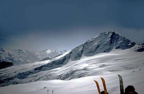 Pizzo Muccia from Zapporthorn - the left skiline is the ski-mountaneering route
Getting There
Starting point is San Bernardino (1608 m)You can arrive here
coming from Lombardia and Ticino along the San Bernardino highway till the southern side of the tunnel.
coming from Chur along the highway of San Bernardino
maps :
CNS 267 - S.Bernardino
Ski route
Starting from San Bernardino, along the road to the Pass till the camping.Follow sign to Alpe Vignone then along the valley keeping the left side (ascending).
When slopes become steep cross right to the saddle.
Follow the east slopes till the ridge (about 2960m).
On foot, with care if there is ice, climb along the horizontal ridge till the summit.
When To Climb
all year longcareful with unsafe snow, a long (500 m) cross may be dangerous for avalanches
 |  |
Camping
This is a typical one day trip.Immediatly north of San Bernardino, along the road to the Pass a fine camping (open all year long)