
-
 20173 Hits
-
 91.45% Score
-
 35 Votes
|
|
Route |
|---|---|
|
|
48.85863°N / 113.69922°W |
|
|
Hiking, Mountaineering, Scrambling |
|
|
Summer, Fall |
|
|
A long day |
|
|
Glacier NP Class II & III, with some airy exposure along the goat trail |
|
|
Overview
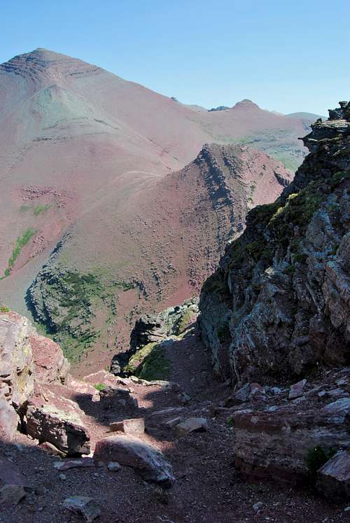
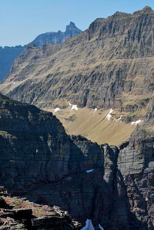
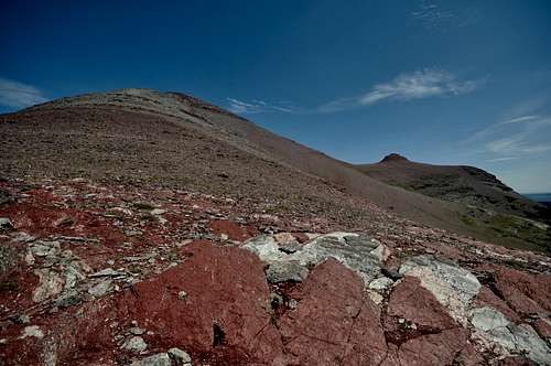
Looking down the marvelous goat trail to Redgap Pass. Seward Mountain at left.
One of the many goat trails that Edwards "sniffed" out over the years connects Ptarmigan Tunnel and Redgap Pass, and it is described in detail in his guidebook. Redgap Pass is often only reached as part of a multi-day backpacking trip, and as such this exhilarating shortcut route allows mountaineers the chance to experience a very remote area over the course of one long day. From the pass, there are multiple options for additional exploration. Seward Mountain can be easily climbed, and a long, scenic ridge winds for several miles to the summit of obscure Yellow Mountain. A great trail connects Redgap Pass to Poia Lake and ultimately the Many Glacier Entrance Road, so many parties utilize this trail to create some variation of a circuit route. This means it's possible to hike for 10-14 hours without retracing many of your steps, which is always a treat.
Getting There
The goat trail originates north of Ptarmigan Tunnel, a popular trail destination in Many Glacier region of Glacier National Park. The rugged Lewis Range slashes through the area, with evidence of long-gone seas of glaciers left behind in the form of sweeping U-shaped valleys and craggy mountain peaks. Only one road accesses Many Glacier, and it begins in the small, unincorporated town of Babb, MT. A paved, pothole ridden road winds westward for 12 miles past famed Many Glacier Hotel to its terminus at the Swiftcurrent Motor Inn. Babb is located on US-89, 8 miles north of St. Mary (a small, busy tourist village at the east entrance of Going-to-the-Sun Road), and 11 miles south of the US-Canadian border crossing at the Port of Piegan (Carway, Alberta).In my experience, this route is almost always completed in a clockwise direction. As such, the route description will begin at the Iceberg/Ptarmigan Trailhead at the Swiftcurrent Motor Inn. Note that this is the terminus of the Many Glacier Road, so as long as you make it Babb and turn towards the park you cannot get lost! If completing this route as a circuit, I recommend stashing a second car at one of the following trailheads on the Many Glacier Road: Apikuni Falls/Poia Lake Trailhead (one mile east of Many Glacier Hotel) or the Poia Lake Cutoff Trailhead (at the Many Glacier Entrance Station). Most parties will take a minimum of 10 hours to travel the goat trail and explore the areas around Redgap Pass before hiking out past Poia Lake, so the additional car will be a welcome sight at the end of what will hopefully be an enjoyably long day.
Route Description
First, and most importantly, START EARLY!!! Even though the goat trail provides a "shortcut" to Redgap Pass, it is extremely strenuous with many ups and downs and challenging route finding. Also, once parties reach Redgap Pass they will likely desire more time to explore the surrounding areas. It would be a shame to put in such great effort to reach a wonderful and remote area like Redgap Pass, only to have to race back to beat nightfall.From the large, busy parking area at the Swiftcurrent Motor Inn, locate the Iceberg/Ptarmigan Trailhead. Follow this trail for 2.5 miles until Ptarmigan Falls is reached. A wooden plank bridge crosses above the falls, and shortly thereafter a trail junction is reached. Bear right to continue to Ptarmigan Tunnel. The trail climbs steadily through forest before reaching beautiful Ptarmigan Lake (4.2 miles from the trailhead). Reliable water sources are hard to come by once you leave the lake, so filter water here if necessary. Continue past the lake, and grunt up a set of three long switchbacks en route to Ptarmigan Tunnel. It's 5.1 miles total with 2,300 feet of elevation gain from the trailhead to this point. Please visit FlatheadNative's great page on the history of Ptarmigan Tunnel for more info on this remarkable feat of human trail engineering.
Looking back at Ptarmigan Lake from the switchbacks leading to Ptarmigan Tunnel.
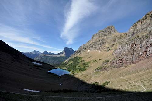
Traveling through Ptarmigan Tunnel is truly an enlightening experience; as you exit the tunnel to the north, one of the more breathtaking trail vistas in Glacier National Park lights up in front of you. The lush Belly River drainage reaches out towards the plains of Alberta, Canada, with serene Elizabeth Lake at the center of it all. Take time to study the colorful, crumbly terrain to the northeast. The towering ridgetop angles severely down and to the left and one point and forms a broad, distinct notch; this is the first destination on the off-trail portion of the route. Continue along the trail as it begins its descent towards Elizabeth Lake. Steep green cliffs tower to the right and a red rock retaining wall protecting hikers from the steep drop borders the trail to the left. A minute or two north of the tunnel, the east face of Mount Merritt, covered by Old Sun Glacier, comes into view. After a couple more minutes, the cliffs on the right are intersected by a tongue of loose scree that streams down the mountainside and across the trail. As the trail bends straight west, the terrain on the right beomces noticeably less steep and easier to climb. Leave the trail at the safest point and slog up the loose steps, taking care not to spray rocks down on your climbing party.
Off-trail route from the Ptarmigan Tunnel Trail to the distinct notch
A solid game trail leads up to the ridgetop
Looking back towards Ptarmigan Tunnel
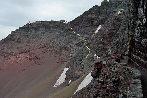
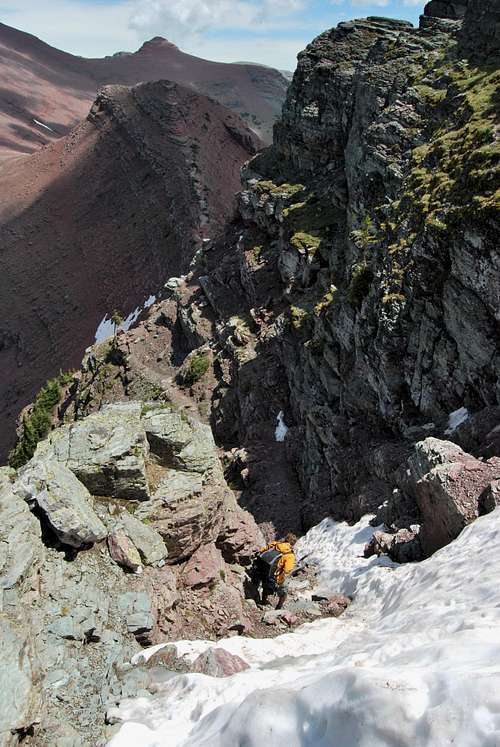
Views from the notch are quite impressive; Mount Cleveland and Mount Merritt dominate the scenery to the west, and to the east Kennedy Creek drains towards the Blackfeet Indian Reservation and the plains of Montana. To the south, Kennedy Lake basks beneath the steep 2,000 foot north face of Mount Henkel. The rounded red hump to the north is that of Seward Mountain, which can be easily climbed from Redgap Pass. From the notch, head north on game trails to continue on the route. Stay near the ridgetop and continue past three large, deep notches with sheer cliffs dropping off to Kennedy Creek. After approximately 1/2 mile, the terrain steepens and a fourth notch is encountered, but it sits some 20-30 below. Carefully climb down and to the left, and follow a distinctive trail bordered by towering spires to the edge of the notch. Here's where the real fun begins.
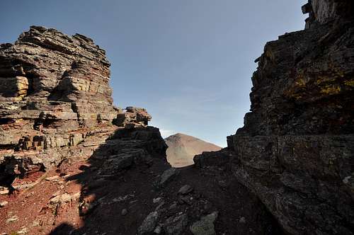
The start of the goat trail
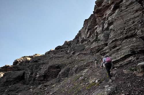
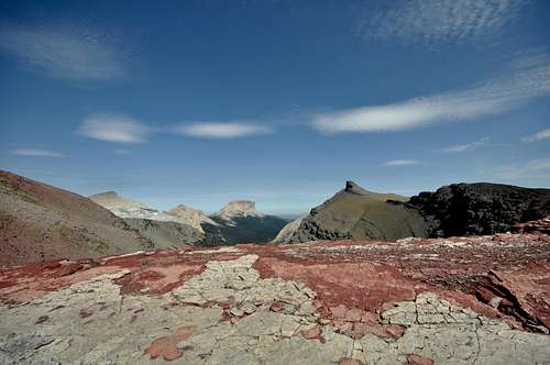
Straight ahead is a marvelous goat trail that slashes downward to Redgap Pass. It truly is a sight to behold, and one that Gordon Edwards describes as follows: "A look down through that notch toward Redgap will surprise and delight even the most jaded mountaineer" (1). Descend through the notch and down the goat trail, taking care to avoid any lingering snow that may cover portions of the trail. If snow completely blocks any portion of the route, do not attempt to climb it unless you are equipped with ice axe, crampons and rope. Lingering, north-facing snow banks can stick here through July, and a slip down the snow could definitely prove fatal! If snow does not block your way, the goat trail involves some class III down climbing with moderate exposure, and generally speaking it is straightforward and easy to follow. The trail is so well-worn and littered with goat prints and droppings that it would be nearly impossible to go off route. After 15 minutes or so, the trail crosses a broad red saddle with great views back to the notch above Ptarmigan Tunnel. From there, many easy routes can be followed downhill to Redgap Pass (7,520 ft). The pass should be reached in ~1.5 hours from Ptarmigan Tunnel.
 |  |  |
|---|
Looking back at the second half of goat trail from Redgap Pass
Welcome to Redgap Pass, where you are a long ways form anywhere! Even though it will take most groups a minimum of 4 hours to reach Redgap Pass, the goat trail shortcut is undoubtedly the shortest route. The windswept pass is rarely visited due to its remoteness, and those that do travel here are often on a multi-day backpacking itinerary. For those on a long day trip, there are four plausible options that can be entertained from Redgap Pass:
1) Retrace your steps. Climb back up the goat trail and carefully make your way back down to Ptarmigan Tunnel.
2) Hike the Redgap Pass Trail back to Many Glacier. The shortest route via trail to civilization entails descending the trail to the east, and in 5.6 miles the backcountry site at Poia Lake is reached. It's a frustrating climb over Swiftcurrent Ridge for 3+ miles to a trail junction, where you are presented with 2 options:
i. A crude trail descends steeply over ~1 mile to the Many Glacier Entrance Station. It's 5 miles back to the Iceberg/Ptarmigan Trailhead from here, so I recommend stashing a second car prior to your hike. Otherwise, hitchhiking is your best bet. Total distance from Redgap Pass to Many Glacier Entrance Station: ~10 miles.ii. Stay on the main trail as it continues another 3 miles or so to the Apikuni Falls/Poia Lake Trailhead. It's 2 miles back to the Iceberg/Ptarmigan Trailhead from here, so unless you've planned ahead with another car, your options are to hitchhike or walk 2 miles (1 on road, 1 on trail) back to the starting point. Total distance from Redgap Pass to Apikuni Falls/Poia Lake Trailhead = ~12 miles.
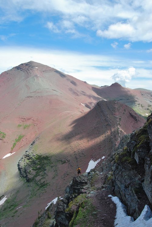
3) The rounded red summit Seward Mountain is within easy reach. It's difficult to discern from the pass, but it's another 1,400 feet of climbing to the summit. The route is a classic, tiring class II scree slog, but it should only take an hour or so. A rapid scree descent to the trail east of Redgap Pass can be made, or an easy ridge can be followed deeper into some wild country towards Yellow Mountain.
Seward Mountain (left) from Redgap Pass
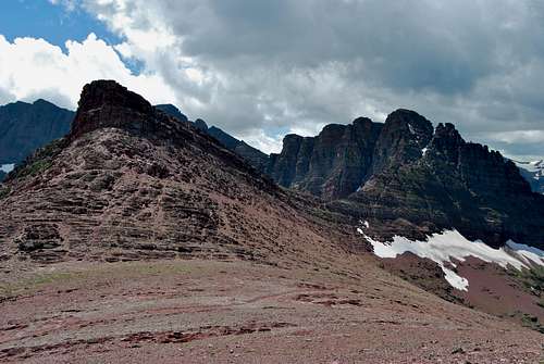
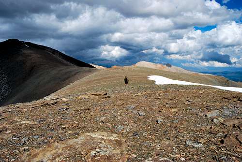
4) Make your way eastward towards Yellow Mountain, either directly from Redgap Pass or after a quick climb of Seward Mountain. From the pass, prominent red hump is visible to the east of Seward Mountain. Game trails traverse the loose southern slopes of Seward all the way to a beautiful saddle (referred to by Gordon Edwards as "Seward Saddle") just west of the hump, from where it's possible to continue on to the faraway summit of obscure Yellow Mountain. It will take most parties 2-3 hours to attain the summit of Yellow Mountain from Redgap Pass. A hasty descent can be made more or less directly to Poia Lake from Yellow's long, scenic summit ridge. Most parties will require a minimum of 12 hours to hike all the way to Yellow Mountain and out to the road via Poia Lake.
View north from "Seward Saddle"
Hiking the long ridge to Yellow Mountain
.
Essential Gear
Class III down climb next to snow
Ptarmigan Tunnel Seasonal Closure
Note that Ptarmigan Tunnel routinely opens in mid-July, and is closed in late September/early October. If it's closed, there is no way possible to continue on towards Redgap Pass from this direction. Inquire with the rangers, or check the NPS trail status report page
Wildlife
Glacier National Park is home to healthy grizzly and black bear populations; hence, it is necessary to take special precautions while hiking. Remember to make noise, hike in a group and carry bear spray (and know how to use it!). Please visit the NPS bear safety page for more information on hiking in bear country. It is also important to remember that other dangerous wildlife like moose and mountain lion inhabit Glacier. It never hurts to check the local trail postings for area warnings/closures regarding wildlife.
Glacier Rock Grading
Due to the sedimentary nature of the rock in Glacier National Park, unique rock grading systems have been established by both Gordon Edwards and the Glacier Mountaineering Society. Please refer to the Glacier National Park Rock & Grading Systems Summitpost page (authored by Fred Spicker and Saintgrizzly) or the website of the Glacier Mountaineering Society for detailed information. If you are new to climbing in Glacier, I highly recommend checking out this info before attempting any climbs in the park. The rock north of Ptarmigan Tunnel and along the goat trail is rotten, as per usual. I would highly recommend donning a climbing helmet for the off-trail portions of this route.
Weather
Things change suddenly in the mountains, and every alpinist has seen clear blue mornings turn into violent, stormy afternoons in the matter of an instant. The area around Redgap Pass is not the place to be during severe weather. The pass is extremely exposed and there is nowhere to run for cover. During my July 2010 trip all the way out to Yellow Mountain, a series of thunderstorms led our group to nearly become lost on our way down from Yellow Mountain. Visibility was reduced to just a few feet, and were lucky to stumble out onto the Redgap Pass Trail with enough time to hike past Poia Lake and the the road before midnight. Check local weather forecasts (I use the NOAA website), be aware of your surroundings, and find shelter or turn around if the weather worsens.
References
1. Edwards, J. (1995). A Climber's Guide to Glacier National Park (1st edition published in 1961). Helena, MT: Falcon Press Publishing Co., Inc.I'd remiss if I didn't give a huge thanks the late J. Gordon Edwards for sharing this route in his guidebook. I will forever be drawn back to Glacier National Park, thanks in large part to the seemingly endless amount of route ideas he shared over the years! As of August 2013, I have been on this fantastic goat trail three times, and I'd like to thank Zach Eagan, Rebecca Lahr, James Hackethorn and Emily Hackehtorn for joining me along the way.