
-
 9741 Hits
-
 75.81% Score
-
 6 Votes
|
|
Mountain/Rock |
|---|---|
|
|
34.67287°N / 84.0163°W |
|
|
Lumpkin / Union |
|
|
Hiking |
|
|
Spring, Summer, Fall, Winter |
|
|
3200 ft / 975 m |
|
|
Overview
 Southeast from overlook
Rising a short distance west of Woody Gap, and guarded on either side by Tritt Gap and Jacks Gap, Ramrock mountain provides some of the best, most open views available along this part of the Appachian Trail. Though the actual summit is timbered, the bare rock outcrops of Ramrock Mountain provide pleasant views of rolling green mountains to the south.
The peak makes for a great short day-hike for road trippers to Woody Gap or a delightful rest stop for AT backpackers. Blaze-orange azalea bloom here in the spring, and the rock overlook provides a fantastic setting for a relaxing lunch.
USGS Quad: Suches
Trails Illustrated Map: #777 Springer & Cohutta Mountains
Getting There

Ramrock Mountain is less than 2 miles southbound on the AT out of Woody Gap. The actual summit is a short jaunt through a campsite clearing from the AT. Woody Gap is about 15 miles north of Dahlonega, Georgia, on GA Hwy 60. Ample vehicle parking is available on either side of the gap off of Hwy 60.
Red Tape
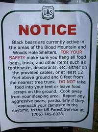 Heed Forest Service bear warnings
 AT crossing at Woody Gap
There is relatively little red tape in this part of the Chattahoochee National Forest. Be mindful of Forest Service user warnings posted at Woody Gap, such as “problem bear” alerts and campfire bans.
Camping & Lodging
 Azalea close-up
 Azaleas in May
Dahlonega: A decent variety of lodging options can be found in nearby Dahlonega, GA, 15 miles south on GA Hwy 60 from Woody Gap. Visit this Trip Advisor page for details.
Suches: Suches, Georgia, is only six or seven miles north of Woody Gap on GA Hwy 60, but the lodging options are more limited.
Car Camping: Car camping can be found at nearby Dockery Lake (take FS 654/Dockery Lake Road, which is about 6 miles south of Woody Gap on GA Hwy 60.
AT Backpacking: The nearest AT shelters to Woody Gap are Gooch Mountain (roughly 4 miles southbound) and Woods Hole (roughly 7 miles northbound).
Weather & Seasons
Spring and Fall are considered by many the most pleasant time to visit the Southern Appalachians. Ramrock Mountain Summit
 Views from the overlook
Spring: In the Spring, daytime temperatures and warm and evenings are cool while the flowering shrubs are in bloom and the waterfalls are running. Water sources such as springs are most reliable this time of year.
Fall: In the fall, the broadleaf deciduous trees put on a bright display of autumn color, though waterfalls may not be as impressive and springs and other water sources less reliable. The air is cooler and crisper and visibility should be prime for long-range views.
Summer: Summer in this part of the country can be oppressively hot and humid and even the higher elevation and ample tree cover will not keep the hiker from feeling overheated, sticky and dirty. High humidity and haze plus deep leaf cover mean limited long-range vistas, though it is in summer that the term “temperate rainforest” will have the most meaning to and be most appreciated by the visitor.
Winter Winters in the South Appalachians can range from cool and damp to cold and severe with bouts of deep snow following major storms. In other words, while this range may be relatively low in elevation and southern in latitude, mountains are still mountains and can bring unpredictable and potentially dangerous weather.