
|
|
Mountain/Rock |
|---|---|
|
|
44.88376°N / 118.16955°W |
|
|
Baker |
|
|
Hiking, Mountaineering, Trad Climbing, Bouldering, Scrambling |
|
|
Summer, Fall |
|
|
8928 ft / 2721 m |
|
|
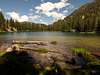
 Red Mountain from Red Mountain Lake
Overview
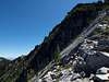
Red Mountain is a member of the Elkhorn Range, which is a sub-range of Oregon’s Blue Mountains. The peak is the third highest peak located in the Elkhorns rising to the height of 8,928’ (2721 m). Red Mountain towers 1,800 feet above a lake of the same name. The peak is a comprised of granitic material associated with the Bald Mountain Batholith which dominates the composition of many of the high peaks in the Elkhorn Range. Visible on the upper slope of the peak is a somewhat smooth granite face sloping at a moderate angle toward Red Mountain Lake. Glacial scarring can be seen on the smooth face providing evidence of the prehistoric Pleistocene Ice Age.The north face is steep and could potentially produce a few technical routes requiring climbing gear. There are two distinct ridgelines descending from the summit of the peak guarding the east and west sides of the lake while a third ridgeline descends from the summit to the south. The two ridgelines to the east and west of the lake provide class 3 scrambling routes to the summit.
From the summit, Twin Mountain dominates the skyline to the north while Mount Ruth is visible to the west. On a clear day the southern edge of the Wallowa Mountains can be seen across the Baker Valley to the east. Rock Creek Butte and Elkhorn Peak the only peaks higher in the Elkhorn Range are visible to the southeast. Many other high peaks in the range are visible from the summit of Red Mountain.
 |
 |
 |
 |
Getting There
From I84 Exit No. 285 at North Powder drive west on Anthony Lake Highway for 7.7 miles to Foothill Road. Turn south and drive on the Foothill Road 2.7 miles to Bulger Flat Road. Turn west on Bulger Flat Road and drive 2.6 miles, to a major fork in the road take the left (south) fork and proceed 300’ to the next fork. (The road at this point only gets worse and requires high clearance four wheeled drive vehicles) At this junction stay to the right (north) and continue another 2.5 miles to the next major road junction. From the four-way junction proceed southeast (continuing straight) 4.4 miles to the trailhead. The trailhead is unmarked and just large enough for a few vehicles to park in. The trail immediately crosses North Fork Powder River and continuing up to Red Mountain Lake. There is a log bridge approx 100’ downstream of the trailhead next to a large log jam stretching across the entire river that can be used to cross the river.From the trailhead at 6,000 feet hike 1.2 miles on the trail to Red Mountain Lake at 7,145 feet. From the lake, the east or west ridges provide access to the summit.
 |
 |
 |
Red Tape
NoneCamping
There are a few hunter campsites along the unmarked forest road 7301 and a small area at the trailhead. For those willing to carry overnight gear up to Red Mountain Lake there are a few sites close to the lake and the view of Red Mountain from the lake is definitely worth the carry.When To Climb
Poor road access to the mountain is the major concern when trying to summit before July. Most climbers attempt the mountain from mid to late July through October before the winter storms limit access.Conditions
Whitman Ranger DistrictBaker Office
3285 11th St.
P. O. Box 947
Baker City, OR 97814
541) 523-4476
Paul McClellan - Sep 25, 2014 2:11 pm - Voted 10/10
Road DirectionsThese are the notes I took while driving towards Red Mountain Lake Trail from the East: 0.0 Turn West on Bulger Flat Lane. 2.1 Road curves left and narrows. 2.6 Pass "LIEN" private drive on your right. 2.7 Continue straight (vs left) at fork. See a sign "ACCESS TO PUBLIC LAND" on your right. 3.1 Cross over a creek on a bridge. 3.8 Continue straight. 5.2 Continue straight at a 4-way junction. See a red arrow painted on a rock ahead. 6.0 Road gets rougher and narrower. 7.0 Pass a hunters' camp on the left at a small meadow. 7.2 Road becomes steeper with many larger rocks. Called "The Rockpile" by a local bow hunter. I turned around and returned to the meadow to camp. 9.5 (approx) look for a road leading left to the unmarked TH.