
|
|
Mountain/Rock |
|---|---|
|
|
44.92824°N / 118.16506°W |
|
|
Baker |
|
|
Hiking, Mountaineering, Scrambling |
|
|
Spring, Summer, Fall |
|
|
8897 ft / 2712 m |
|
|
Overview
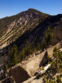
Twin Mountain is located in the Elkhorn Mountains a sub-range to the larger Blue Mountain Range of eastern Oregon. It’s located south of the Baker Valley and can be seen driving along Oregon’s main east to west Interstate 84. It’s a massive peak with the summit “ridgeline” extending from the northeast to the southwest with the true summit located close to the center along the ridge.Access to Twin Mountain is limited making it one of the harder peaks to climb in the Elkhorn Mountains. Dutch Flat Trail parallels the northwest side of the peak and extends the entire length of Twin Mountain while the National Forest Road 7301 parallels the southeast side of the peak. Both the trail and road provide access to the flanks and can be used as starting points to the peak. Trails leading up to the summit of the peak are nonexistent.
Getting There
Whether coming from the north or south on Interstate 84, take exit 285 at North Powder and head west on North Powder River Lane (county road 101) for 4.0 miles. Turn left on Ellis Road and continue for 0.6 mile to the junction with the Anthony Lakes Highway. Turn right on the Anthony Lakes Highway and continue for 7.8 miles to the junction with National Forest Service Road 7307. Proceed northeast (left) on FS road 7307 for 1.3 miles to the end of the road which is the Dutch Flat Trailhead (Trail #1607).
Red Tape
Although not posted at the trailhead on the forest service website the forest service states that a Northwest Forest Pass is required for parking at this trailhead.
When To Climb
Late June through October. The trailhead is below 5000’ so there may be access to the trailhead in early June depending on the snowpack for the year. The Anthony Lake Highway is open year round to the Anthony Lakes Ski Area. Snow typically can be found along the summit ridge until mid to late July.Camping
A campground is located at Anthony Lake which is an additional 7.9 miles on the Anthony Lakes Highway from the junction with FS road 7307. It appears that there’s enough room at the trailhead for overnight camping and there are places along the Dutch Flat Trail for primitive camping.Current Conditions
Current trail and road conditions can be obtained from the US Forest Service:Whitman Ranger District
3285 11th St.
P. O. Box 947
Baker City, Oregon 97814
(541) 523-4476