
|
|
Mountain/Rock |
|---|---|
|
|
40.81667°N / 113.95467°W |
|
|
Tooele |
|
|
Hiking, Mountaineering |
|
|
Spring, Summer, Fall, Winter |
|
|
6212 ft / 1893 m |
|
|
Overview
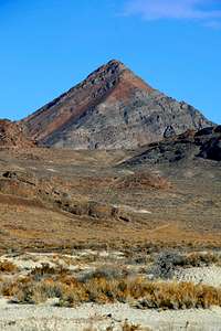
Rishel Peak is a fin-like desert peak in the Silver Island Mountain range in Utah's west desert. The peak was created by volcanic activity, and it clearly shows several layers across its steep faces. Like the rest of the remote and rugged Silver Island mountains, Rishel Peak has no established trailhead and no trails to its summit. Rishel Peak has no water sources, no trees, and no possibility of shade. The best seasons to hike Rishel Peak are spring, fall, and winter. This peak is named for Bill Rishel, who drove a Pierce-Arrow car on the salt flats left from old Lake Bonneville in 1907 to test their suitability for driving.
Getting There
From anywhere in the universe, find exit #4 on Interstate 80 in Utah's west desert near the Nevada border, also the exit for the Bonneville Speedway. From the exit, travel north and follow signs for Leppy Pass. From Leppy Pass, take the first right turn onto the dirt Silver Island Mountains Backcountry Scenic Byway. From the turn onto dirt, travel 3.3 miles. This is the trailhead for two wheel drive vehicles. Park off the road. 4WD or higher clearance 2WD vehicles can follow the double track road to the east for another mile or so.
Red Tape
This is Wilderness area. Follow all wilderness rules and stay on the roads.
Camping
 Rishel from Volcano Peak
There are no established camping areas in the Silver Island mountains. Dispersed wilderness camping is allowed. Follow Leave No Trace principles and obey wilderness rules.
jfrishmanIII - May 26, 2011 8:44 pm - Hasn't voted
Lat/LongNice page, but check your lat/long coordinates. Rishel is showing up in southwest Montana.
ZeeJay - Jan 16, 2015 6:32 pm - Voted 10/10
Lat/LongThe correct lat/long is N40.8167 W113.9546
utahgreen35 - Aug 10, 2015 1:54 am - Voted 4/10
Geology 101First, you created a decent page, I'm glad it's here. However, I have two corrections. First, those layers you referred to , most of them limestone, mean they were deposited over the eons layer by layer mostly as sediment on the floor of an ancient sea. It's obvious that the East face most clearly displays those layers as this is a >Fault block< mountain, similar to most Great Basin ranges, which has been uplifted on the East side and tilted at about a 40 degree angle from horizontal. The West face consists of the topmost 2 or 3 layers. In fact, the most direct route to the summit climbs on top of the uppermost limestone layer only. As opposed to SE side routes, which would cross multiple layers of rock. Volcano Peak to the SW is a volcanic plug remnant, Rishel Peak is not. Second, I appreciate the leave no trace ethic. I'm glad you mentioned it. I didn't find any manmade detritis on the mountain itself which was encouraging. However, neither Rishel Peak or the surrounding area is a Wilderness Area.
1L-19 - Sep 30, 2017 2:19 pm - Voted 7/10
Re: Geology 101Rishel is on BLM land, so people need to follow those rules when camping. I saw a few fire pits around. You don't have to stay in designated camping spots (there aren't any). Just minimize your impact and pack out what you pack in, common sense.
1L-19 - Sep 30, 2017 2:40 pm - Voted 7/10
I summited Fri. 9/29/2017Great day, sunny with a few broken clouds. Temperature was perfect, 65-70F with a brisk wind. I'll post some pics. I parked south/uphill about a mile from Silver Island Loop Road. My RAV4 did fine. If you take a Chevy Cavalier up there, you're probably not going to make it. I followed a ridge of knolls south up to a saddle, that'll be your first look over the salt flats. Then I turned 90 degrees and following the ridge all the way to the summit. I'll post a Google Earth screen-grab, which will show it a lot better than I can say it. In some places, I didn't want to climb 10-15 foot cliffs, so I walked on the south side of the ridge there, no big deal. Most of the climb is over loose rock, a mix of flat sheets standard notebook paper size and softball sized rocks. Total climb is 1400-1600 vertical feet depending on where you park.