

-
 9798 Hits
-
 81.18% Score
-
 13 Votes
|
|
Mountain/Rock |
|---|---|
|
|
46.53885°N / 7.71266°E |
|
|
Mountaineering, Trad Climbing |
|
|
8474 ft / 2583 m |
|
|
Overview
Ärmighorn from the north (Kandersteg)
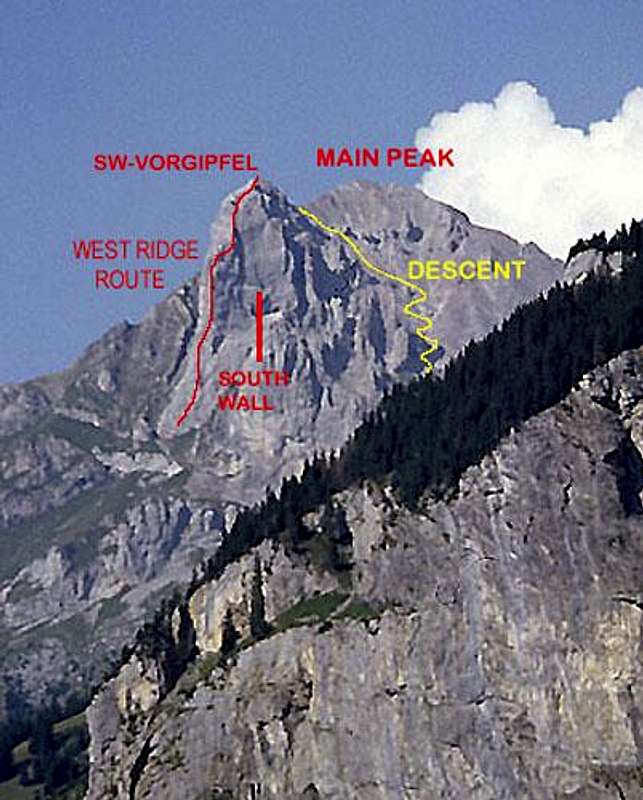
The Ärmighorn (2742 m.) is a small limestone peak located between the Kandertal and Kiental on the west end of the Bernese Alps. The main summit is of little or no interest as a climbing objective, but the SW-Vorgipfel (SW-fore summit) has some of the finest limestone climbing routes on this end of the range. The West Ridge is included by Hans Grossen in his book BERNER OBERLAND Die 100 schönsten Touren (The 100 best climbs in the Berner Oberland). There are at least 10 routes ranging from IV+ to extremely difficult sport climbs on the peak.
From the summit, one has an excellent view of the Balmhorn, Doldenhorn, Fründenhorn, and Blümlisalphorn Group
An excellent closer view of Ärmighorn
Getting There
The long hike up from the valley can be shortened by taking a private lift from Mitholz to Giessenen Alp - about one and a half hours from the alp to the peak. Or, by driving a private mountain toll road from Kandergrund - about two hours from the end of the road. NOTE - at least one report from 2009 states that this cable car is no longer available for use - check locally for updates and/or further information.TOPO MAP

Top of lift
Routes
GUIDEBOOK Plaisir WestThe classic route on the peak is the West Ridge variously rated as IV+ or V-. It is an outstanding very steep ridge climb about 300 meters in height with at least 7 pitches. The route closely follows the most logical route up the ridge. Most belay stances are fixed, and there is some fixed protection.
The difficult sport climbs are located on the steep south wall (S-Wändli) to the east (climber's right) of the ridge.
 On W Ridge On W Ridge |  On W Ridge On W Ridge |  On W Ridge On W Ridge |  View down W Ridge View down W Ridge |
Descent
The descent is mostly a walk off with one fixed chain on a nasty spot. It is about an hour and a half back down to the alp and very steep - be sure to take hiking boots.  Summit view north Summit view north |  On descent On descent |  On descent On descent |
Overnight
The Ärmighorn is an easy day climb from nearly any valley base in the Berner Oberland or even possibly from further away. The closest towns of "size" are Kandersteg and FrutigenI suppose that if one were so inclined that you could camp in the meadows below the peak.