
-
 6050 Hits
-
 80.33% Score
-
 12 Votes
|
|
Mountain/Rock |
|---|---|
|
|
46.86512°N / 9.11241°E |
|
|
Mountaineering |
|
|
Summer, Fall |
|
|
10194 ft / 3107 m |
|
|
Overview
Ruchi as seen from Muttsee
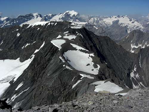
Within the circle of peaks, surrounding the once beautiful Muttsee, Glarus Alps, Ruchi is the highest summit, reaching exactly 3107 m. “Once beautiful” means: there is a huge building site around the lake and the Muttseehütte, extending nearly over 1 km!
It is the construction site of a huge pump storage power station, using the water power of the Limmeren dam at a height of 1850 m and the newly built Muttsee dam at a height of 2450 m. As the power station at Tierfehd, the valley village, is at 800 m, there is an altitude difference of 1650 m between the valley and the upper dam. Consequently this water power plant will deliver a quantity of electric power comparable to an atomic power plant! The whole project will be finished in 2015 and hopefully will give back a bit of the peace and remoteness the Muttsee once had. Nevertheless there will be a new and long dam to extend the water capacity of (once natural) Muttsee. On the contrary many people will get “clean electric energy”.
Actually you have a nice view on this construction site from Ruchi. Thank God the views on the Glarus Alps and the adjacent Swiss regions are nicer. As Ruchi is located northeast of the Tödi main massif the views on Tödi, Bifertenstock, Clariden and Selbsanft are impressive.
Ruchi is located north of Muttenstock and south of Hintersulzhorn. Hausstock, the highest summit of the subarea, is located northeast of Ruchi; their connecting ridge via Chli Ruchi (the Little Ruchi) is one of the normal routes to Hausstock summit and – to my opinion – the best and most interesting route of the subarea.
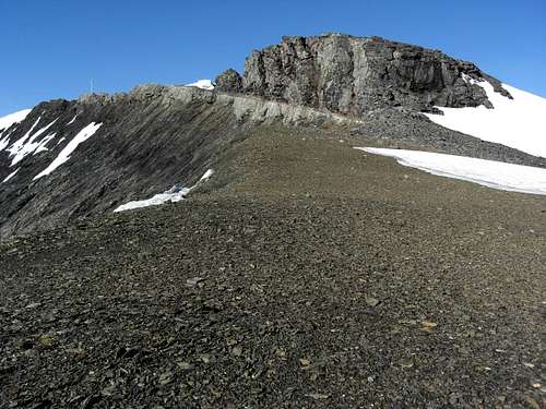
Ruchi itself is a long, north – south running ridge, separating the high Muttsee plain from the Cirques north and east of the summit. These cirques still have some glaciers: Hintersulzfirn to the north, located in the Kanton Glarus and Glatscher da Cavadiras, already belonging to Kanton Graubünden. Thus Ruchi is a frontier summit between these two Swiss areas.
Nevertheless Ruchi is a relatively easy hiking summit when tackled from Muttsee hut. This normal route uses the western slopes of Ruchi and the western snow field which is the rest of a former glacier. There are cairns and foot tracks guiding you up to the summit. The route, however, is very steep and in some parts exposed. Don´t underestimate this summit if you are a “normal” hiker. For a skilled mountaineer Ruchi is a nice afternoon walk from Muttseehütte or the appetizer before summiting Hausstock.
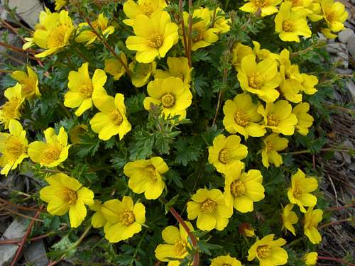
 Ranunculus alpestris |  Viola cf. tricolor |  Linaria alpina |
Getting There
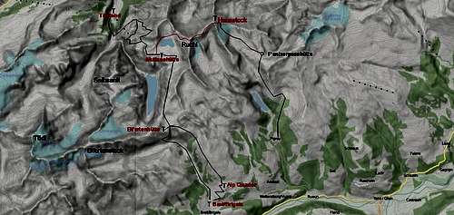
Valley trailheads for Ruchi are
By car:
By train and/or bus
The nearest railway station to the north is Linthal. Check the SBB schedule here.
Taxi busses can be hailed for a quick drive to Tierfehd (1,5 hours walk by foot).
Tavanasa is the nearest southern railway station (Oberalp Bahn from Andermatt / Disentis-Muster or from Scuol / Tarasp). Check the SBB schedule here.
Brigels/Breil can be reached by bus from the railway station Tavanasa.
Routes Overview
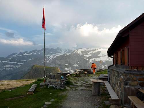
Muttseehütte
The main mountain trailhead for Ruchi is Muttseehütte.
You reach Muttseehütte
 Geum reptans | 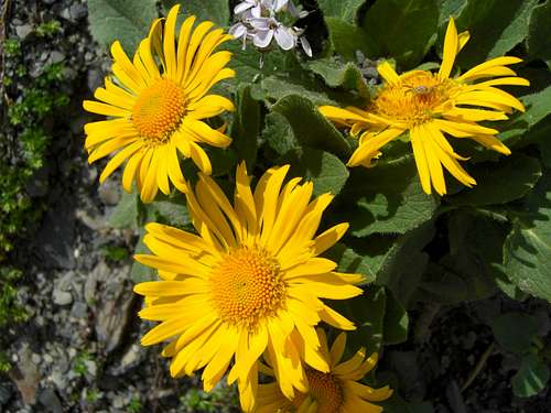 Doronicum species, seen in the Muttsee protection area | 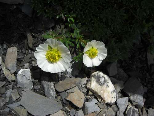 Ranunculus alpestris on the west slopes of Ruchi |
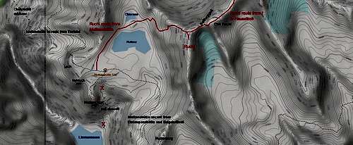
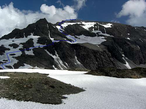
Summit route from Muttseehütte
From Muttseehütte use the trail in western direction (ascend trail from Tierfehd) until you reach a marked trail junction after about 300 m from the hut. Follow now closely the marked trail as you enter the nature protection site “Muttsee” which should be respected despite of the huge construction site for the water power plant.
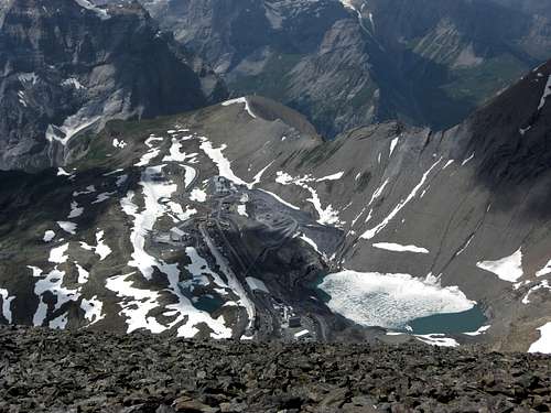
Muttsee and construcion site as seen from Ruchi
This trail circles round Muttsee on its western and northern side until you reach the creek coming down from little Obersee lake, north of Muttsee lake. Cross the creek and follow the hill crest between Obersee and Muttsee. Ascend now the slope below the notch, called Hintersulzlücke until you are half way up. Turn right now to gain an easy way through some rock faces above Muttsee on the western slopes of Ruchi. There are many cairns and a good track indicating the right route. Some easy rock scramble!
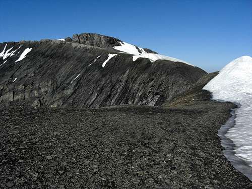
Now you enter the mostly snow filled cirque west of Ruchi summit. Ascend the snow steeply up to its left (= north) rim and leave the cirque on some easy rock ledges (trail again) up to the steep northwest ridge of Ruchi. Follow the steep trail zigzagging up the ridge until you reach the summit rocks.
Summit route from Hausstock
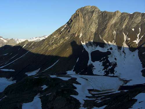
Ruchi and the connecting ridge as seen from Hausstock; Tödi and Selbsanft in the background
Ruchi summit is part of the traverse Hausstock to Muttseehütte. So you can rate Hausstock as a “trailhead” for Ruchi, too, when climbing Hausstock via Glatscher da Mer route, coming from Panixerpasshütte and continuing to Muttseehütte.
Descend from Hausstock summit cross shortly in western direction to gain the southwest ridge. Follow the cairns on the ridge, there is nice talus and rock scramble involved until you arrive at the col between Hausstock and Chli Ruchi. At this col you can study the Glarus main thrust fault as described in the “Geology” chapter below; Hausstock summit block is built up of old Verrucano rocks, at the col you see the white Lochseiten limestone, marking the sharp thrust zone with the Tertiary marlstones below.
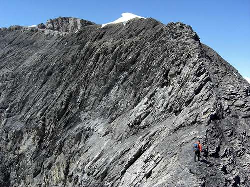
Follow the cairns and the foot tracks easy up to Chli Ruchi (Little Ruchi), a secondary summit within the connecting ridge Ruchi – Hausstock.
Between Chli Ruchi and Ruchi is located the deeply cut in Seilfurggeli notch. Furggeli means small, narrow notch, Seil means rope. That is it: you have to descend steep and slippery marlstones down to the notch (south face of Chli Ruchi) and ascend again steeply up to the summit plateau of Ruchi. Exposed and rather tricky with snow and ice. In former times you had to belay that notch traverse with ropes, nowadays there are heavy iron chains to help you down and up again.
Turn right to gain the summit block of Ruchi northwest of the summit.
 Seilfurggeli and Ruchi summit | 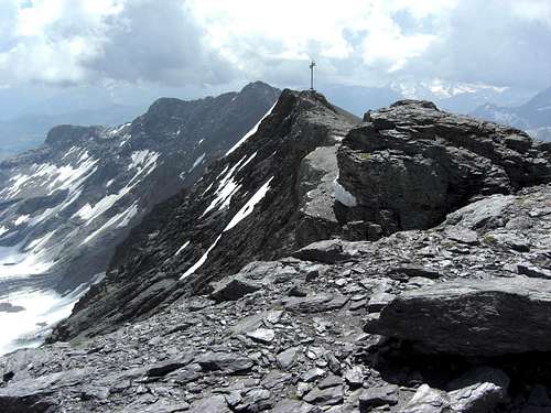 Ruchi summit |
Geology
If you are interested at least a bit in geology and the tectonical structure of the Alps, the Glarus region is one of the most interesting areas. And Ruchi shows a very concrete key element of this structure.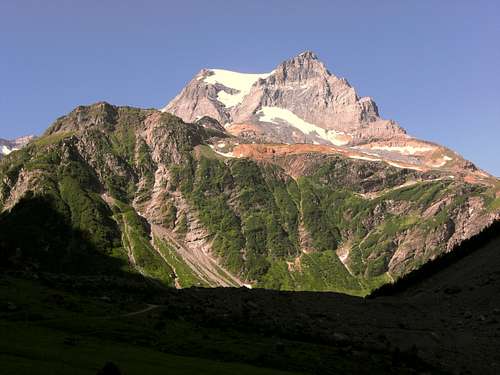
Tödi as seen from Hintersand; triassic (yellow stones) and jurassic limestones on top of metamorphic rocks
On the whole Glarus Alps are part of the so called “Helvetikum”, an area formerly locates at the northern rim of the old Tethys ocean, the predecessor of today´s Mediterranean sea. On this continental rim, on granites and metamorphic rocks, which come to surface in the Urner mountains, the neighbouring area of Glarus Alps to the west, which can be studied, too, at the end of Sand valley, northeast of Tödi, sedimentation of marine rocks started in the early Triassic period and and went on through millions of years until in the Tertiary age the alpine mountain building processes started.
This whole “package” of sediments can be studied starting from Hintersand below Tödi up to Selbsanft massif and Muttsee, where huge Jurassic limestones build the mountains and form the landscapes (many karst features can be seen). Starting from Muttsee up to Ruchi you will find mostly softer marlstones, representing the cretaceous and tertiary ages. Erosion built the huge Muttsee high plain by withering and carrying away the softer marlstones above the more resistent limestone deposits.
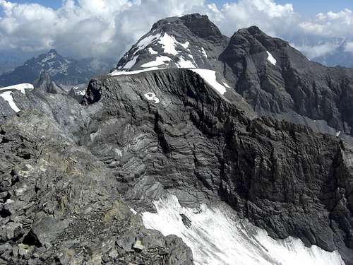
Ruchi summit with the Glarus main thrust fault
Standing a bit north of Ruchi summit on the broad ridge to Chli Ruchi and Hausstock you may recognize a significant change of rock quality within Ruchi summit block. There is a north dipping bed of white limestone on top of the tertiary marlstones underlying a massive block of solid rock with crystalline features. The joint between these two rock types is razor-sharp and striking as the bedding of the Tertiary marlstones is oblique to the white limestone and the razor-sharp joint.
Geological research shows that the underlying Tertiary marls have an age of about 35 to 50 million years and the overlying solid rock of about 250 to 300 Million years. This older rock is called “Verrucano”, a conglomeratic sediment, deposited in late Permian age. The sedimentation of such an old rock on much, much younger rocks is not possible. In fact Ruchi summit is part of a famous geological feature within Glarus Alps which recently has become UNESCO World Natural Heritage: the Glarus main thrust fault.
During alpine orogeny a huge nappe south of the todays Glarus Alps was transported at least 40 km north and thrusted with is basal Verrucano rocks over the young tertiary marlstones. The whole thrust zone is north dipping: in the southeastern Glarus Alps you find the thrust zone near the summit level at 3000 m or above (Ruchi, Hausstock: the summit block is built up of Verrucano, Sardona, Ringelspitz, Tschingelhörner), to the north the Glarus main thrust fault disappears below valley ground, surfacing near the town of Glarus at “Lochsite” where this phenomenon can be studied easily after a five minute walk from your car.
The Lochsite geological situation can be seen, too, as a copy at New Yorks “American Museum of Natural History”.
Hausstock summit with the Glarus main thrust fault
The Glarus main fault thrust shows as a good example the tectonical structure of the Alps which are built up by different nappes, pushed from south to north by the compression forces during the closing of the former Tethys ocean and the northbound drift of Africa. If you go north from Glarus Alps you will discover more nappes overlying each other thus forming other huge summits and ranges as Glärnisch or Churfirsten / Walensee. It was at Glarus Alps where geologists first understand the nappe building of the Alps: Hans Konrad Escher von der Linth and his son Arnold, Marcel Alexandre Bertrand and Albert Heim.
Immediately at Ruchi summit this fundamental element of the alpine geological structure can be seen clearly. Maybe another factor to summit Ruchi.
Red Tape & Accommodation
Kistenstöckli as seen from Muttsee area
The area around Muttsee is a nature protection site of Kanton Glarus, the regulations say not to leave the marked routes.
I respected this regulation despite of the construction site which lays partly within the site. The chief geologist of the construction site explained us during some evening beers that renaturation has high priority after the work is finished. Let us hope that the fragile protection site with its beautiful plants and flowers will survive and improve again.
You find accommodation at:
Mountain huts:
Gear & Mountain Condition
Ruchi is a summer and autumn mountain; an early ascent (june, july) from Muttseehütte is recommended due to the lingering snow, covering the dreadful scree slopes of the normal route ascent.The route from Muttseehütte is easy but steep and in some parts exposed. The traverse to Hausstock is a route for mountaineers, due to the steep and exposed Seilfurggeli traverse.
So don´t underestimate Ruchi.
You need full hiking gear, good shoes, crampons and an ice axe for ascents early in the year or when traversing from and to Hausstock summit.
 Nüschenstock as seen from Ruchi ascent | 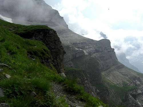 Nüscheness and steep meadows; ascent to Muttseehütte |
Current Weather for Linthal:
Current weather for Breil
Map & Guide Books
Ruchi as seen from Chli Ruchi
Maps
Landeskarte der Schweiz, scale 1 : 25.000, number 1193, Tödi, 2005
Guide Book
Schweizer Alpen Club: Hansueli Rhyner, Ruedi Jenny, Samuel Leuzinger, Glarner Alpen, Alpine Touren, 2013
Bergverlag Rudolf Rother, München: Ulrich Tubbesing, Gebietsführer Glarner Alpen, last edition 1991, out of print (try it with antiquarian booksellers)