

|
|
Area/Range |
|---|---|
|
|
47.04194°N / 9.06647°E |
|
|
Hiking, Mountaineering, Sport Climbing, Ice Climbing, Skiing |
|
|
Spring, Summer, Fall, Winter |
|
|
11857 ft / 3614 m |
|
|
In Memory of Cyrill Rüegger
 A note from the SP staff
Cyrill Rüegger, the member we all used to know as Cyrill and Digitalis, died on June 13th 2009 in an avalanche on the summit ridge of Piz Palü together with his wife Tanja and a common friend. They were swept down by the avalanche into a couloir underneath the east summit and died instantly. Their bodies were retrieved from the Palü Glacier by helicopter a day after the accident.
Cyrill joined SP in March 2006 and soon was one of the most prolific contributors on the site with almost 70 mountain and 5 range pages to his profile. He was an accomplished climber, bagging almost 1000 summits in not quite seven years. Among them are 35 4000ers and 272 3000ers, almost all of them in his home country Switzerland.
While contributing a lot on SP, Cyrill's real internet home was www.hikr.org where he contributed 585 mountain profiles and reports in his native language German. Cyrill also posted on www.bergsteigen.at and other climbing sites, often under his real name but also under the pseudonym Digitalis. He was a botanist by profession and also contributed his knowledge about medical plants to different websites. Cyrill will be greatly missed by all.
This page will be kept in honour of Cyrill, one of SP's most prolific members and most active mountaineers.
Rest in peace, brother!
The picture above was taken on the summit of Matterhorn on July 28th 2007.
Overview
The Glarner Alps are the mountains within the Swiss-kanton of Glarus. This small Kanton is defined mainly by the valley which runs from it's northern end south to the capitol, also named Glarus, and then further south curving West until it reaches the border with the kanton of Uri at Urnerboden. The kantonal border follows the ridgelines which define the line of sight for most of the kanton, which means that many of the mountains outside the central region share allegiance with the neighboring kantons of Graubunden, Schwyz, St. Gallen and Uri.Glarus is region visited infrequently by mountaineers as it has none of the giant 4000ers of the Berner and Valais alps, but it's remoteness also makes it one of the finest areas for mountaineers who like to get away from the crowded summits elsewhere in the alps.
Despite the lack of 4000ers, Glarus still has some epic mountains to climb... Perhaps the more so for their remoteness and general lack of mechanical support. It is not unusual for Glarner mountains to require a 5 hour hut walk followed by a long summit climb on the following day.
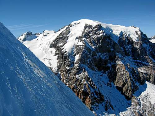 Tödi / Piz Russein 3614m/11857 ft - highest mountain in Glarus Alps
Summits in the Glarus Alps
Tödi / Piz Russein 3614mBiefertenstock 3419m
Piz Urlaun 3359m
Clariden 3267m
Hausstock 3158m
Ruchi 3107m
Piz Tumpiv 3101m
Muttenstock 3089m
Bocktschingel 3079m
Piz Sardona 3055m
Hinter Selbsanft 3029m
Piz Segnas 3012m
Gemsfairenstock 2972m
Glärnisch 2914m
Tschingelhoren 2846m
Laaxer Stöckli (Piz Grisch) 2806m
Bös Fulen 2801m
Schächentaler Windgällen 2764m
Geissbutzistock 2719m
Ortstock 2716m
Gross Schiben 2654m
Hanenstock 2561m
Foostockli 2536m
Gemsistock 2530m
Magerrain 2524m
Spitzmeilen 2501m
Wissgandstöckli 2488m
Mürtschenstock 2441m
Gufelstock 2436m
Charenstock 2320m
Gandstock 2200m
Fronalpstock 2124m
Rautispitz 2163m
Ruchsitenstöckli 2351m
 Clariden 3267m
Mountain Huts & Refuges in the Glarus Alps
Clariden-hut 2453m > Link to Clariden hutFridolins-hut 2111m > Link to Fridolins hut
Glärnisch-hut 1990m > Link to Glärnisch hut
Grünhorn-hut 2448m > Link to Grünhorn hut
Kistenpass-hut 2729m > Link to Kistenpass hut
Legler-hut 2273m > Link to Legler hut
Martinsmad-hut 2002m > Link to Martinsmad hut
Muttsee-hut 2501m > Link to Muttsee hut
Planura-hut 2947m > Link to Planura hut
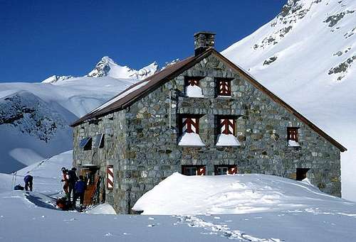 Clariden hut
Alpine passes in the Glarus Alps
Kisten pass 2640mLimmeren pass 2612m
Panixer pass 2407m
Läcki pass 2334m
Foopass 2223m
Klausen pass 1955m
Pragel pass 1550m
Books & Map for the Glarus Alps
Guidebook Summer:Alpinführer Glarner Alpen
Author: Peter Straub
Guidebook winter / ski tour:
Skitouren Glarus, St. Gallen, Appenzell
Alpine Skitouren 5
by Marcel Kraaz , Thomas Wälti
Skitouren Graubünden
Vital Eggenberger
Online maps of Switzerland:
www.mapplus.ch
Map Search - Online Maps
Weather, climate and snow conditions in Switzerland
Federal Office of Meteorology and ClimatologyWeather SFDRS
Meteo News.ch
Swiss Federal Institute for Snow and Avalanche Research Davos: www.slf.ch
Links over the Glarus Alps
Switzerland Tourism: www.myswitzerland.comGlarus tourism: www.glarusnet.ch
Canton Glarus homepage: www.glarus.ch
Good and favorable accommodations: www.rooms.ch
