
|
|
Mountain/Rock |
|---|---|
|
|
46.84194°N / 8.87111°E |
|
|
10722 ft / 3268 m |
|
|
Overview
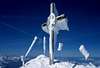
Clariden is a very popular ski mountain, because it is centrally located between the 2 main Swiss highways that cross the Alps: Gotthard and Bernhardino. These 2 highways are connected with the Klausenpass road (1948 m) which can be easily accessed both by Zurich and Lucerne, i.e. by eastern and central Switzerland. As soon as this road opens in May (ca. ) over hundreds of cars are parked on an average Sunday in May and June on the pass by enthusiastic Clariden ski-climbers. Some skiers from the Zurich side even start in March or earlier, drive to Linthal (by car or train), and walk from 800m to the Clariden hut at 2453 m. Skiing is usually not considered to be a dangerous sport, but Clariden asks every year for a deadly victim at the so called Eiswand (Iswändli), a narrow passage 2 hours above Klausenpass. Why? Some skiers just get frightened when they have to ski over an easy ridge 15 feet wide. Or they get lost in fog, ski down too much to the right and end 500 m deeper within seconds. Still, I recommend Clariden, and did it with my two sons in their teens, but my wife just hates the Eiswand and refuses to follow me. In 2001 I was witness of a teenager falling over the wall, then met his erring father looking for his son.... Don't hesitate to climb this mountain, but have discipline and concentration at the Eiswand and on the summit ridge.Clariden is a snow clad mountain that is rather boring to climb during summer, expect if you decide to climb the icy north face.
 |  |
Getting To The Top
1. From Clariden hut (2453 m) over the Claridenfirn towards the summit. Just before the top, turn right to a little saddle and then to the top. This route allows you to ski completely to the summit. 4 hours. Easy.2. From Klausenpass (1948 m) to the foot of the Rau Stöckli, then over the Tierälpligrat to point 2861. Pass the Eiswand (Iswändli), then traverse below the Kammlijoch (3021 m) towards the the west ridge. Leave the skis below 3193 (Clariden Vorgipfel) and walk over the ridge to the top. 4 hours. From rather easy to difficult, if icy or foggy. Sometimes easy without rope, without axe, without crampons.
3. From Planura hut (2947 m) over the Hüfifirn to Kammlijoch (3021 m) then over route 2 to the top. Staying at the Planura hut makes only sense, if this is part of a weekly trip combining mountains around the Hüfi and Fridolin hut. 2 hours.
4. North face from Vorfrutt (1779 m) on the Klausenpass road or from Klausenpass. Enter the huge cauldron Im Griess and reach 2353. Traverse more or less horizontally to the east. The ice climb starts exactly below the summit. The wall is almost 1000 m high. For an experienced ice climber it is not too difficult. 8 hours.
 |  |  |  |  |
Red Tape and Infromation
No red tape.Map Nr. 1193 Tödi 1:25'000
Clubführer Glarner Alpen (SAC)
Alpine Skitouren: Zentralschweiz-Tessin
See the Swisstopo Map with many interesting features. Upload is in a seperate window.
When To Climb
Klausenpass opens usually in May. Ideal skiing months: May/June. Possible ascents via Clariden hut all year round. Nice during a long February/March high pressure period.Accommodation
For skiers mostly a one day trip. In summer there are beds and dorms at the Hotel Klausenpasshöhe 1840 m. This link shows among other things a webcam. Many other recommended mountains in the vicinity: Schächentaler Windgälle, Scherhorn, Gross Ruchen.1. Clariden hut 2453 m. 5 hours from Tierfed (behind Linthal). Additional interesting routes.
2. Planura hut 2947 m. From Klausenpass 5 hours. Recommended only in combination with other huts.
 |
Mathias Zehring - Jan 3, 2005 4:51 pm - Voted 10/10
Untitled Commentthere is already an SP mountain Group "Glarus Alps" (for german Glarner Alpen) so the page should be adjusted to this group