Day 1, Thursday March 31st 2011
I had a long weekend a couple weeks ago to celebrate out schools annual "Engineering Days" and I decided to spend it in Utah while all my colleagues got wasted.
So on Wednesday evening I took the long drive out from Denver taking the usual stops in Grand Junction and Green River. Got to see a great sunset on the road just as I passed the state line. I finally arrived at Justensen Flats late at night which was as far as my little car could go. I pitched the tent and went to sleep.
I awoke to a nice sunrise and I prepared the mountain bike. I had planned on shortening my 2+ mile approach by biking. Starting down the road I quickly saw some nice views open up and rode down the hill towards the bottom of Devils Canyon.
![Devils Canyon]() Devils Canyon
Devils Canyon
Soon after getting down my tire went flat. I knew it was going to happen since this bike was cheaper than a bottle of water! As I write this now I just got myself a nice mountain bike to use in the future.
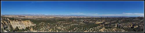
So I ditched it and started walking towards the San Rafael Knob. As I slowly climbed the views became better and better.
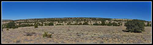
![Sinbad Country]() View into Sinbad Country
View into Sinbad Country
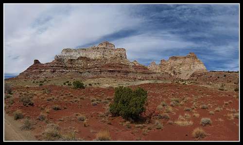
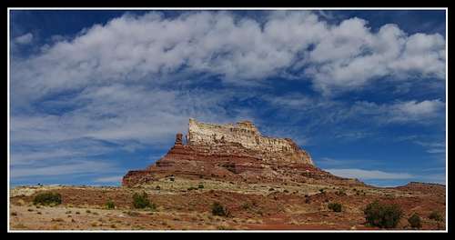
The Knob was in view nearly the entire time and before I knew it I was at the base ready to scramble up. However I didn't do all my research and it took me a long time to find the right way up. All I knew was "Northeast Ridge".
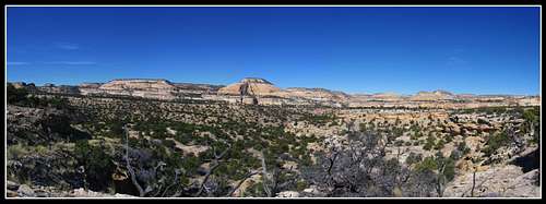
I finally got to the right slope and here the views really became good.
![San Rafael Knob]() View into Sinbad Country
View into Sinbad Country
After about a half hour of climbing I got to the summit. I probably shouldn't have done it being by myself but it wasn't really bad.
![San Rafael Knob Summit]() View from the summit
View from the summit
From here I had to walk back to the bike.
![Sinbad Country]() View from old 4 wheel drive road
View from old 4 wheel drive road
Once I got back to the bike I tried to replace the tube only to get sand everywhere so I just carried it back up the wash and up the road.
![Deep Sand]() Deep Sand in the Wash where I ditched the bike
Deep Sand in the Wash where I ditched the bike
This was harder then I had expected and by the time I got back to the car I was exhausted and it was already in the 80's by 1:00 pm when I returned.
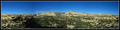
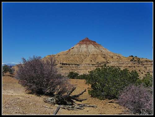
After packing up the bike I drove a few miles east on I-70 and parked just off the Sinbad Road. I wanted to get a look at the Wickiup. I may note that from this point on the entire trip was devoted to photography. I didn't do anything really extreme the remainder of the trip.
Since I brought a spare wheel for the bike I biked up the old road heading northwest towards the Wickiup.
![Open Meadows]() View from the old road
View from the old road![The Wickiup]() The Wickiup
The Wickiup
I could have climbed it right them but laziness took its toll!
After returning to the car I headed to Hanksville to pick up a burger and started on my way to Bryce Canyon. The sun set on my while I was passing through Escalante.
![The Squeeze]() The Squeeze on I-70
The Squeeze on I-70![San Rafael Reef]() San Rafael Reef from I-70
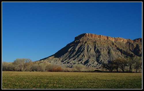
San Rafael Reef from I-70![Caineville Mesa]() Caineville Mesa seen from highway 24
Caineville Mesa seen from highway 24
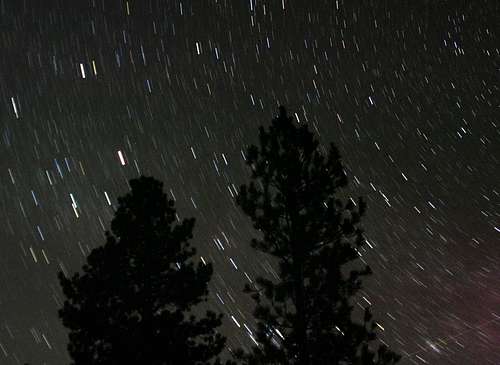
Made it to Bryce pretty late where I pitched the tent just outside the NP boundary. Since it was so warm I attempted to get some nice star trail shots and experimenting with different odd light sources. This is the best I could do.
![Star Trails]() Star Trails
Star Trails![Star Trails]() Star Trail photo using the car headlights to light the trees
Star Trail photo using the car headlights to light the treesDay 2, Friday April 1st 2011
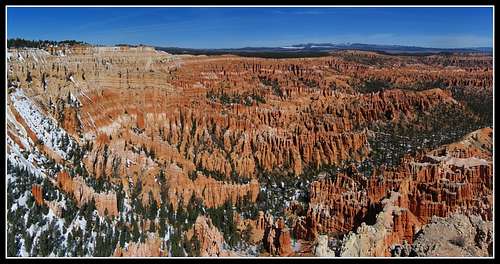
I awoke early and quickly made my way into Bryce Canyon to see the sunrise. This was one of the better Utah sunrises I've seen. Captured it from Sunset Point just into the park.
![Bryce Canyon Sunrise]() Sunrise at Bryce Canyon
Sunrise at Bryce Canyon![Bryce Canyon]() Sunrise at Bryce Canyon
Sunrise at Bryce Canyon
I spent the rest of the morning hitting up all the viewpoints. I wanted to take a hike down into the hoodoos but there was still about 3-4 feet of snow and ice on the trails making them very hazardous.
![Bryce Canyon]() Bryce Canyon from Inspiration Point
Bryce Canyon from Inspiration Point![Bryce Canyon]() Bryce Canyon from Inspiration Point
Bryce Canyon from Inspiration Point![Bryce Canyon]() Bryce Canyon from Inspiration Point
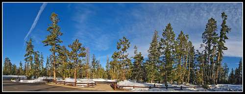
Bryce Canyon from Inspiration Point![Bryce Canyon]() Sunrise on the trees at a viewpoint parking lot
Sunrise on the trees at a viewpoint parking lot
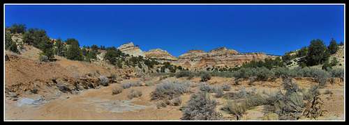
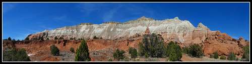
After leaving Bryce Canyon I headed to Kodachrome State Park to take advantage of the perfect afternoon.
I did the little 6 mile loop hike around the western part of the park.
I was able to get some very nice panoramas of the area.
![View at Kodachrome]() Kodachrome State Park
Kodachrome State Park![Kodachrome State Park]() Kodachrome State Park
Kodachrome State Park![Kodachrome Trails]() Kodachrome State Park
Kodachrome State Park![Kodachrome Panorama]() Kodachrome State Park
Kodachrome State Park![Kodachrome State park]() Kodachrome State Park
Kodachrome State Park![Kodachrome Panorama]() Kodachrome State Park
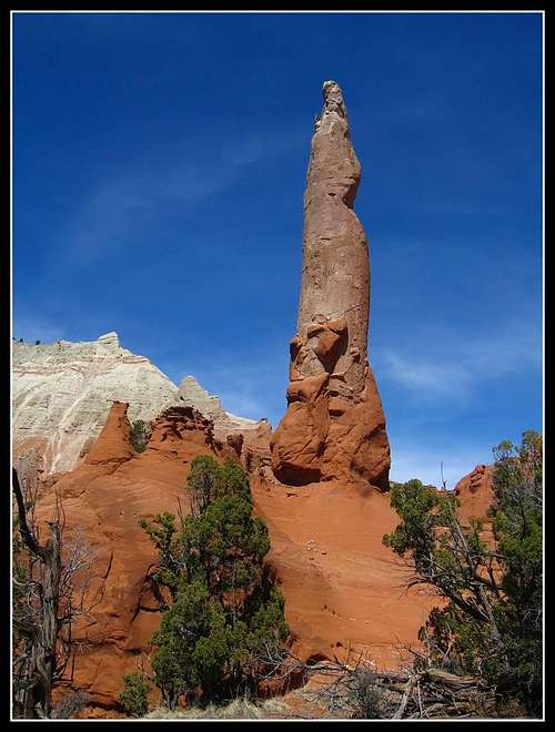
Kodachrome State Park![Rock Pipes]() These rock pipes really got my interest for their anomalous geology
These rock pipes really got my interest for their anomalous geology
From here I drove back through Escalante and to Boulder where I had to decide to either return to Torrey via highway 12 the way I came down, or take the Burr Trail to Bullfrog. I knew about the place where the Burr Trail crosses Clay Canyon all the way down near its end at Highway 276. This crossing can sometimes be flowing with water especially in March and April. I took the risk and went down the Burr Trail as I knew it was a dry winter; unlike the winter of 2009-2010.
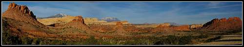
I continued to drove the poorly paved road for many miles only seeing a couple cars. When I crossed into Capitol Reef National Park I was treated with some of the best lighting I've ever seen. The sun was about an hour from setting and I had an east view all the way down.
![Capitol Reef Panorama]() Late afternoon on Capitol Reef
Late afternoon on Capitol Reef![Car Shadows]() Late afternoon on Capitol Reef...car shadow
Late afternoon on Capitol Reef...car shadow![Capitol Reef]() Late afternoon on Capitol Reef and the Henry Mountains
Late afternoon on Capitol Reef and the Henry Mountains
I descended the switchbacks after stopping to talk to another photographer also taking advantage of the great lighting. A dirt biker also passed by.
I continued south on the nice gravel road and was stopping every few minutes to take photos!
![Capitol Reef]() Sunset over the Henry Mountains
Sunset over the Henry Mountains![Capitol Reef sunset]() Sunset on the grey colored Mancos Shale cliffs to the east of the reef
Sunset on the grey colored Mancos Shale cliffs to the east of the reef
I hit pavement again and headed towards Highway 276. This part of the Burr trail was very pretty as there were purple flowers lining it the entire way. Didn't see anyone down that far.
Just as I finished the descent down into Clay Canyon I crossed my fingers I would be able to cross...which I was. There was a small trickle of water; not enough to prohibit my little car from crossing (whew).
Shortly after I captured the late sunset.
![Sunset near Lake Powell]() Sunset over a small pond on the Burr Trail
Sunset over a small pond on the Burr Trail![Perfect Sunset]() Sunset on the Entrada Cliffs near the end of the Burr Trail
Sunset on the Entrada Cliffs near the end of the Burr Trail
Shortly after that last photo it got dark and I drove down to Bullfrog where I camped. Tried some more star trails and was up pretty late as it was very warm down that low in elevation. Managed one good one.
![Star Trails]() Star Trails at the Bullfrog Marina
Star Trails at the Bullfrog Marina
There were just enough lights around from the marina to make the trees have a little color to them.
Day 3, Saturday April 2nd 2011
The sunrise over the marina was another beautiful sunrise.
![Bullfrog Marina Sunrise]() Sunrise over Bullfrog Marina
Sunrise over Bullfrog Marina![Bullfrog Marina Sunrise]() Sunrise over Bullfrog Marina
Sunrise over Bullfrog Marina![Bullfrog Marina]() Sunrise over Bullfrog Marina
Sunrise over Bullfrog Marina
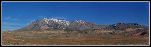
After about an hour I started the drive back to Hanksville up Highways 276 and 95.
![Mt. Hillers]() Mt. Hillers from Highway 95
Mt. Hillers from Highway 95
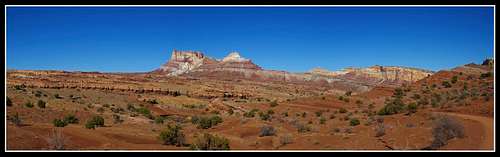
I stopped in Hanksville for another burger and went to Temple Mountain. I spent the rest of the day around Temple Mountain and on the Behind the Reef Road photographing the mountain.
![Temple Mountain]() Temple Mountain
Temple Mountain![Temple Mountain]() Temple Mountain
Temple Mountain![Temple Mountain]() Temple Mountain
Temple Mountain![Temple Mountain]() Temple Mountain
Temple Mountain
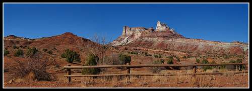
I also managed to hike around the mountain to see the sides I haven't seen before. This was about a 7 mile loop.
![Temple Mountain]() Temple Mountain
Temple Mountain![Temple Mountain]() Temple Mountain
Temple Mountain
When I got back to the camp after the loop hike a man managed to get one of his tires exploded on his truck and needed to get into Hanksville for a tow. He apparently drove on the flat tire for a couple miles because he couldn't get the last lug nut off to put his spare on. By the time he got out of the rough roads he was on the rim was nearly destroyed. So I helped him out and took him and his dogs into town where he was able to get a tow.
I had a plan to meet a group at 5 pm that day and had a couple hours left to kill so I figured I could help someone out.
The group I was meeting came right on cue and I was going to camp the night with them and give them some detailed info on some Escalante slots I've done in the past. They were spending the next week down there and were really interested in Red Breaks (after seeing my SP page).
By now clouds were rolling in and I knew the drive back the next day was going to be bad in the mountains but I stayed the night next to Temple Mountain with loads of other people and gave them all the info I knew about it and gave them some other recommendations of good Escalante slots.
We hit the tents when it got dark after some more talking about Colorado mountaineering, Utah canyoneering, and worldwide traveling (since this is all I can talk about with other avid outdoorsman!)
Day 4, Sunday April 3rd 2011
Just as I had thought, it was raining when we woke up and after wishing them a good trip I quickly left around 7 am knowing the mountains were going to be bad especially for a 2 wheel drive car. After getting back on the interstate it soon began raining hard and by the time I got to Glenwood Springs, signs on the road said Vail Pass was closed. To make a long story short, I was stuck in Vail for 3 hours and didn't get back to Golden until 8:00 pm. I was happy to see many other 2 wheel drive cars on the roads struggling to get anywhere very fast and sliding everywhere holding up traffic after the pass opened. I managed to only struggle to get started once which is a lot better then many of the Colorado Natives did!
Although a long 13 hour trip home I found it amusing.


Comments
Post a Comment