
|
|
Area/Range |
|---|---|
|
|
37.57770°N / 105.485°W |
|
|
Hiking, Mountaineering, Trad Climbing, Big Wall |
|
|
Spring, Summer, Fall, Winter |
|
|
Sangre de Cristo Mountains Overview
"The glamour of lost history – dim memories of Indian bands, of French explorers and Spanish troops; they have the spell of the remote, the mystery of recesses that are little known; they are the kind of mountains one's imagination builds." – Albert Ellingwood after completing the first ascent of the Crestone Peaks in 1916
Spanning two states, the Sangre de Cristo Mountains are one of the longest fault-block mountain ranges in the world. From Salida, Colorado, the Sangres stretch 225 miles to Santa Fe, New Mexico, but if you follow their crest through all its jogs from Poncha Pass to its terminus at Glorieta Pass, the range's length exceeds 300 miles. In Colorado, they are among the most dramatic peaks in the state, soaring up to 7000' from the surrounding valleys with a bare minimum of foothills. My heart sings every time I enter the San Luis Valley or drop into Westcliffe from over the Wet Mountains.

The Sangre de Cristos are host to ten fourteeners, including the renowned Crestone Peaks, and 86 thirteeners, one of which is New Mexico's state highpoint, Wheeler Peak. You'll find the highpoint of 12 counties in the the range, as well. Two of North America's classic climbs can be found in the Sangres: Crestone Needle's Ellingwood Arete route and The Prow on Kit Carson Peak. Other well regarded technical routes in the range include the Little Bear to Blanca Peak traverse and Ormes Buttress on Blanca's incredible north face.
The Sangres are easily divided into three main subsections: (1) the high and narrow northern core, stretching from Poncha Pass to La Veta Pass, which includes the Crestone Peaks and the Sierra Blanca, (2) the Culebra Range, which penetrates into New Mexico all the way to Big Costilla Peak, and (3) the remainder of the New Mexico Sangres, including the Latir Peak, Wheeler Peak and Pecos wilderness areas and the Cimarron Range. On the flanks of the Sangres lies one of Colorado's four National Parks, which protects the Great Sand Dunes, North America's tallest dunes and a product themselves of the Sangres' abrupt topography. Over a half-million acres of the Sangres lie within one of six federal wilderness areas.
In Spanish, Sangre de Cristo means "Blood of Christ." There are two competing theories as to how this name arose. The most common one is that the name refers to the blood-red color the range assumes during sunrise and sunset. Because the Sangres rise to such great heights in just a few horizontal miles, it's hard not to find an excellent vantage from either valley floor for nature's daily photic fireworks. The other theory involves the story of a Spanish priest mortally wounded by an arrow. In his death throes he supposedly cried, "Sangre de Cristo," but partly because I've never seen a name attached to this priest, I've often wondered if this theory started out in jest.
The Sangre de Cristos mark the southern end of the Rocky Mountains, and as such, their history since Europeans arrived is lengthier than any other range in Colorado. In fact, Colorado's oldest town, San Luis, which was established in 1851, lies in the valley just west of the Culebra Range. It feels older in the Sangre de Cristo Mountains. While walking through virgin aspen stands or traversing between the high peaks, you can sense this deep history permeating the mountains, whispering in your ears.
Looking back further, Native Americans called the valleys home and the mountains their source of sustenance for millenia. Blanca Peak, the tallest peak in the Sangre de Cristos, is one of the Navajo people's four sacred mountains, which defined the boundaries of their land. Interestingly, the Navajo chose compact and prominent subranges for each of their sacred mounts: Blanca Peak of the Sierra Blanca, Mount Taylor of the San Mateo Mountains, Humphreys Peak of the San Francisco Peaks, and Hesperus Peak of the La Plata Mountains. Each sacred peak is said to be fastened to the earth by different things, and these icons are are used to symbolize the peaks in artwork and religion. For Blanca, the sacred peak of the east, this symbol is appropriately enough a lightning bolt.
The Sangre de Cristo Mountains are represented well on SummitPost, so please enjoy the excellent mountain pages that are here. Some must-see Sangre de Cristo pages include Culebra Peak, Crestone Needle, Pico Asilado, Milwaukee Peak, Tijeras Peak and North Truchas Peak. There are many summits in the Sangres without pages, however, so I continually look forward to new submissions. One I keep hoping for is a page about the caves on Marble Mountain!
Geology
Most people know that Denver is the Mile High City, that much of the city lies at or near an elevation of 5280 feet. However, geologists believe that Denver and its surroundings didn't always rest at such lofty elevation. During the Miocene period (between 5.2 & 23.3 million years ago), the North American plate, as it drifted westward, thrust over much of the Pacific Plate. According to Roadside Geology of Colorado, "As [the North American plate] reached the Pacific mid-ocean ridge, huge new forces must have developed, forces great enough to reach the continent's interior, lifting it up as much as 5000 feet."This event not only raised Denver to its present level, it also stretched the continent to its breaking point. At a pair of deep faults that penetrate all the way through the crust and down to the mantle, the earth's crust cracked, marking the genesis of the Rio Grande Rift, a massive split in the continent that reaches from the upper Arkansas River Valley all the way into Mexico. For reasons that are not yet clear, the Colorado Plateau experienced a clockwise torsion, helping to pull the rift's edges apart and allowing the land within to drop thousands of feet. The land within the rift didn't fall thousands of feet at once, but rather 5-10 feet at a time over millions of years. (A magnitude-7.3, 1983 earthquake dropped the Thousand Springs Valley west of Borah Peak, Idaho, by nine feet. This event is analogous to the numerous times that the Rio Grande Rift must have subsided.) The formation of the Rio Grande Rift was key in the creation of several mountain ranges. At the head of the Arkansas, the Sawatch and the Mosquito ranges, formerly a single range, were sundered. Further to the south, the Sangre de Cristo Mountains, the youngest of Colorado's major mountain ranges, had begun to arise.
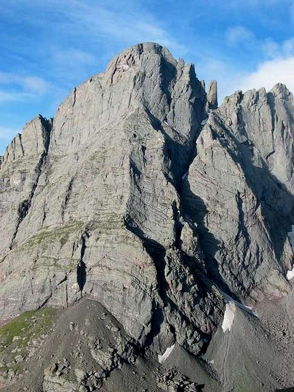
Milwaukee Peak crux
Today when you climb in the Sangre de Cristos, the San Luis Valley is the portion of the Rio Grande Rift that you'll see. This flat, expansive intermontane valley is the size of Connecticut, and while a map will tell you its elevation at ground level, its true base is many thousands of feet below. The major fault on the east side of the valley is the Sangre de Cristo fault. Geologists have determined that rocks found in the Sangre de Cristo Mountains are displaced by nearly four vertical miles from the same type of rocks in the valley. That's right, to find the same suite of Precambrian rocks that form the core of the mountains 6-7000 feet above the valley, you'd have to dig 13,000 feet below the valley's floor. Millions of years of erosion and volcanic activity have filled the valley to its present height with sediments and pyroclastic flows.
The Sangre de Cristo's beginnings actually predate the Rio Grande Rift, however, so we need to take a quick step back. During the Laramide Orogeny, the period of uplift that gave rise to most of Colorado's mountains, the pre-Sangres and pre-San Luis Valley also experienced some uplift. This uplift was anticlinal in nature, the most common method of mountain building in Colorado. The southern section of the Front Range (today we call them the Wet Mountains) was rising concurrently and counteracted the proto-Sangre anticline on its east side, which resulted in the development of thrust faults. These faults allowed the earth's crust to relieve stress as basement rock was thrust bodily over the younger sedimentary rock. This occurred at least eight times over, with sedimentary rock squeezed between each layer of basement rock like some octuple-decker sandwich. Locales on the east side of the range near Comanche Peak are ideal for viewing evidence of this early history of the range. With our uplifted mountain block now in place, we've set the stage for the Rio Grande Rift to shake things up.
The creation of the Rio Grande Rift ushered in a period of earthquakes and volcanics. Amidst this violence, the Sangre de Cristos continued to rise, and their uplift was enhanced by the San Luis Valley's – and to a lesser extent the Wet Mountain Valley's – continued subsidence along the fault zones. Geologists believe that the faults along the Sangre de Cristos are still active due to the shape of its ridges. Whereas the end of ridge will typically erode to a point, many of the ridges on the west side of the Sangres end with a triangular facet, which provides evidence of active faulting. Additionally, fault scarps at the northern end of the range tell us that range continues to rise at an average of an inch every one-hundred years. Whether this uplift is currently outpacing erosion is another question, however!
Summing up, although an anticline provided the raw material, the range's basement-rock core, the Sangre de Cristo Mountains stand proud as Colorado's only fault-block range. Without the downdropped valleys to their either side, without the extensive faulting, they wouldn't be the mountains we know today.
Grinding ice put the finishing geological touch on the Sangres, with glaciers carving out valleys and rock faces throughout the range. The same prevailing winds that helped create the Great Sand Dunes (see the 'Geology' section on the Sand Dunes page), also tend to drift snow onto the eastern side of the range. Therefore, glaciation was less significant on the west side of the range than on the east, where glacial tongues during the height of Ice Ages reached all the way to the Wet Mountain Valley's floor. On the west side, on the other hand, glaciers extended down to 9500 feet at the most, and some drainages remained ice-free below 11,000 feet. Consequently, the Sangres' most dramatic terrain typically is found on the eastern side of the range crest, and most of the lakes are on the east side as well. The Sangres are replete with examples of this trend. On your map take a look at Hunts Peak, Fluted Peak, or Tijeras Peak, and you'll find cliffs on the east side and slopes on the west.
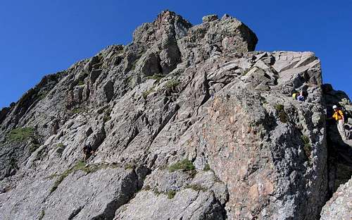
Crestone Conglomerate rock above Willow Lake
Crestone Conglomerate
The sedimentary rock found in the Sangre de Cristos received brief mention above, but it deserves more coverage. Most of the sedimentary rock remaining on the high peaks of the Sangres is of the 300-million year old Sangre de Cristo Formation. This formation is easily recognizable because of its red color. This formation came about from the erosion of the Ancestral Rockies and is contemporaneous with the similarly reddish Maroon Formation of Maroon Bells fame and the Fountain Formation, well-known because it makes up the beautiful Red Rocks Amphitheatre and Boulder's Flatirons.
Some of the most delightful climbing in the Sangre de Cristos can be found where the range is capped with the Sangre de Cristo Formation rock known as Crestone Conglomerate. This rock features a jumble of pebbles, stones, and even boulders from a variety of sources all cemented together in sandstone. Because the sandstone erodes more quickly, the cobbles and rocks that are suspended in it tend to form knobs that provide convenient and solid handholds and footholds. Many of the peaks in the core of the Sangres including and surrounding the Crestone Peaks are wrought from this conglomerate. Beyond the fourteeners, some of the peaks that feature Crestone conglomerate include Mount Owen, Broken Hand Peak, and Milwaukee Peak.
Spanish Peaks
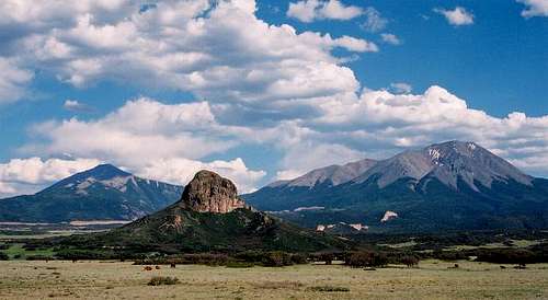
Spanish Peaks
Also deserving of special mention are the Spanish Peaks south of La Veta. Travelers of the I-25 corridor between New Mexico and Pueblo or on US-160 between Walsenburg and Alamosa are privy to jaw-dropping views of these incredibly prominent peaks. In truth, geologically they are a separate and compact range of their own, but their proximity to the Culebra Range means that geographically they are usually grouped with the Sangre de Cristos. The two peaks, East Spanish and West Spanish are enormous masses of igneous rock. Under tremendous pressure, magma was forced upward, doming the overlying sedimentary rocks. The magma's heat was so intense that it "baked" a 900-foot-wide zone around each intrusion, metamorphosing the sedimentary rock in that zone into a much more resistant state. This all occurred between 21 and 27 million years ago, and since that is the same period of instability during which the Rio Grande Rift began to form, some have speculated that both of these events are related. It's believed that the Spanish Peaks are much lower than their former height, so it's likely that West Spanish Peak was a fourteener not too long ago!
The defining characteristic of the Spanish Peaks are the hundreds of igneous dikes that radiate outward from the two peaks. Nowhere else in the world do igneous dikes occur in such great profusion. These dikes were formed as the magma pushed upward. Because of the enormous pressure, magma squeezed and penetrated into vertical cracks in the sedimentary rock and cooled. Millions of years of erosion took its toll on the surrounding sedimentary rock, leaving rock walls standing behind. The dikes range in width from 3 feet to 100 feet and can be as long as 17 miles! The Spanish Peaks are actually just two of several igneous intrusions in the area, all of which have their own dike system on a smaller scale, including Mount Maestas near La Veta Pass.
History
The history of man's interaction with the Sangre de Cristo Mountains starts thousands of years ago. Excavation sites in the San Luis Valley reveal that nomads hunted and foraged in the area, but there is little evidence of permanent occupation until the Capote band of the Ute Indian tribe settled there. The Utes are the oldest continuous residents of Colorado. They maintained control of the valley through the arrival of the Spanish, but in the mid-1800's former Mexicans began to take residence in the valley, disrupting their lifestyle.
In 1821, the same year that Mexico achieved independence, the Vegas Grandes grant was made to Don Luis Maria Cabeza de Baca, descendent of 16th century explorer Cabeza de Vaca who is known for being the first to journey across the southwest United States, traveling from Florida to Arizona. After the U.S. took control of the region following the Mexican-American War, the government endeavored to resolve claim disputes. By the 1860's there were many homesteaders who had settled on the Vegas Grandes grant without permission from de Baca's heirs. Rather than put the homesteaders off their land, the government gave the Baca heirs a choice of equally large grants elsewhere. One of the parcels they chose was in the San Luis Valley, and this became known as the Luis Maria Baca Grant #4. This massive tract of land has been sold and subdivided many times over the years, but the original grant long ago still influences access to the Sangre de Cristo Mountains even today. This grant is the reason behind the blocked southern access to the Sierra Blanca and the status of that most exclusive of private mountain enclaves, the Culebra Range. To learn more about the tangled history of the Culebra Range, please visit the Culebra Peak page.
Zebulon Pike was the first American to travel through the Sangre de Cristos as part of his exploration of the Louisiana Purchase. For more about Pike's winter traverse of the range, please refer to the 'History' section of the Great Sand Dunes page. In 1851, Colorado's oldest town, San Luis, was founded, and in 1858, the U.S. Army erected a garrison at Fort Garland to protect settlers from the Native Americans, especially the fierce Comanche tribe. Among his many exploits, Christopher "Kit" Carson, for whom the 14er is named, was for a time commander of this fort.
The Wet Mountain Valley's recent history starts with a group of German colonists, and their influence is evidenced by several names in the area: the Colony Creeks and Lakes, Humboldt Peak, and Wulsten Baldy to name a few. Silver was discovered near Westcliffe, which attracted more settlers and a railroad. Maybe you've wondered why there are two, small, separately incorporated towns, Westcliffe and Silver Cliff, directly adjacent to each other in the mostly empty valley. During the silver rush, a group of Westcliffe residents felt they were being cheated by the water company. They packed their things, moved up the road, and founded their own town!
Since the passage of the federal Wilderness Act in 1964, the Sangre de Cristo Mountains have been repeatedly recognized for their pristine and primal qualities. New Mexico's Pecos and Wheeler Peak wilderness areas were established with the initial 1964 act, and the Latir Peak Wilderness followed in 1980. The first wilderness designation for Colorado's Sangre de Cristos had to wait another 13 years for the passage of the Colorado Wilderness Act, the flagship of which was the 226,000-acre Sangre de Cristo Wilderness. This wilderness area has subsequently lost acreage to the Great Sand Dunes Wilderness, which was created as part of the new Great Sand Dunes National Park and Preserve in 2004. The smaller Spanish Peaks Wilderness, Colorado's easternmost wilderness, was established in 2000.
Access
From Poncha Pass to Hayden Pass: Access from the west is nearly unfettered in this section of the range. There are only two formal trailheads here, Dorsey Creek and Decker Creek, but you'll be able to access any of the drainages without worrying about private property. From the east, there is one problem to note. Between the Bear Creek and Kerr Gulch Trailheads, there is no public access. This is a burden for those wishing to hike the Hunts Lake Trail or bushwhack up one of many other drainages, including Cherry Creek, West Creek, and Howard Creek. Thankfully, the Rainbow Trail connects Bear Creek to Kerr Gulch, so if you're willing to make the effort, all the drainages on the east are open to you.From Hayden Pass to Broken Hand Pass: Nearly every drainage in this section of the Sangres hosts a trail. On the west, there are several drainages without public access, including Steel Canyon southwest of Nipple Peak. Special note should be taken of Spanish Creek and Cottonwood Creek. Sadly, these two drainages start on private land, and as of August 1, the landowners have chosen to block public access. On the east there are a few locations where access is more difficult, and again the Rainbow Trail is of great value. The mouths of the following drainages are blocked to the public: North and South Brush Creeks, Greenleaf Creek, Texas Creek, Swift Creek, Macey Creek, and North Colony Creek.
From Broken Hand Pass to Medano Pass: From the west, access is impaired in this section of the range. Deadman, Pole, and Sand Creeks are all blocked from San Luis Valley public access. The National Park Service could eventually alleviate the situation with Sand Creek, but it's possible that no trailhead will ever be established at the mouth of Deadman Creek. On the east side, because the range splits in two at Broken Hand Pass, access to each and every east-flowing drainage is not a primary concern. The access provided by Music and Medano Passes is more than adequate for reaching Sand Creek and Medano Creek.
From Medano Pass to the Sierra Blanca: From the west, you're denied access only to the Arrastre Creek drainages. From the southwest, getting to Tobin Creek is something of an adventure, but it is legal. From the east, the Huerfano River is the primary point of access, though it should be noted that people are not permitted to access the forest via the South Fork of the Huerfano River or Montezuma Creek. From the south is a different story entirely. Public access is denied to Blanca Creek, Little Ute Creek, and Ute Creek. Thankfully, even though Mount Lindsey and the Winchell Lakes are on private land, access is permitted as long as you come from the Huerfano River valley.
Spanish Peaks: West Spanish Peak is typically accessed from the south via Cordova Pass. Access to the saddle between the west and east peaks does not appear to be permitted via the South Fork of Trujillo Creek, but people do hike to this saddle from the north and Wahatoya Campground, the preferred trailhead for East Spanish Peak. Other access from the north is blocked, including Echo Canyon, Wade Canyon, and Chapparral Creek. Eastern access to the Spanish Peaks is not available. The Chapparral Trail off the Cordova Pass Road provides access to the three White Peaks west of West Spanish Peak.
Culebra Range: The king of poor access in all of Colorado is the Culebra Range. The only free public access is on the eastern side of the range between Indian Creek and Trinchera Peak. Chief points of access include Indian Creek, Bonnett Creek, Spring Creek, and most importantly Cucharas Creek. All other eastern access to the range is completely barred. Currently, you can climb Culebra Peak from the western side of the range by making arrangements ahead of time with the Cielo Vista Ranch and paying a fee. The Culebra Range's problems extend into New Mexico where Big Costilla Peak is another mountain that's off-limits to the public.
New Mexico: If you are willing to compile similar access information for New Mexico, please let me know!
Skiing
Most of New Mexico's ski areas are located within the Sangre de Cristo Mountains. Please visit this site for a list of New Mexico ski areas: Ski New Mexico. If you have information you'd like to share about New Mexico's ski resorts, please contact me.In Colorado, on the other hand, Sangre de Cristo ski areas have been a losing proposition. The snowpack in Colorado's Sangres simply cannot compare to the lofty totals found elsewhere in the state, contributing to the demise of the range's two most recent ski areas. Conquistador near Westcliffe hasn't operated since 1992, and Cuchara Valley, in the Culebra Range, has been closed since 2000.
The Sangre de Cristo Mountains' snowpack consolidates earlier than the other ranges in Colorado due to low snow accummulation and warmer temperatures. Stable snowpack can be found as earlier as March.
| Peak | Route | Difficulty |
| Blanca Peak | West Face | Advanced (1) |
| Crestone Peak | Northwest Couloir | Extreme (1) |
| South Face | Extreme (1) | |
| Crestone Needle | South Face Couloir | Extreme (1) |
| Kit Carson Mountain | O.B. (North Couloir) | Extreme (1) |
| The Prow | Extreme (1) | |
| West Face via Challenger Point | Advanced (1) | |
| South Couloir (Cole's Couloir) | Advanced (1) | |
| Humboldt Peak | West Ridge | Intermediate (1) |
| South Slopes/Southeast Gully | Intermediate (1) | |
| Challenger Point | Kirk Couloir | Extreme (1) |
| North Face of Challenger | Advanced (1) | |
| Culebra Peak | Taylor Ranch | Intermediate/Advanced from Summit (1) |
| Mount Lindsey | North Face Couloirs | Extreme (1,2) |
| Southeast Face | Intermediate (1) | |
| Ellingwood Point | Southwest Face | Advanced (1) |
| Little Bear Peak | West Ridge | Extreme (1) |
| Horn Peak | Horn Peak Trail | ? |
References
1. Dawson's Guide to Colorado Fourteeners Vol. 2: The Southern Peaks
2. Personal observations
Skiing table and additional information contributed by kalet
Sources
Halka Chronic & Felicie Williams – Roadside Geology of ColoradoJohn Fielder - Mountain Ranges of Colorado
Ralph Lee Hopkins & Lindy Birkel Hopkins - Hiking Colorado's Geology
Randy Jacobs & Robert M. Ormes - Guide to the Colorado Mountains, Tenth Edition
Jason Moore – Hiking Colorado's Sangre de Cristo Wilderness