
|
|
Mountain/Rock |
|---|---|
|
|
36.02370°N / 51.94890°E |
|
|
Mountaineering |
|
|
Summer |
|
|
13566 ft / 4135 m |
|
|
Overview
Click for Introduction to the Central Alborz MountainsClick for a detailed map of the Central Alborz Mountains.
 Northern Slopes
 Southern Slopes
Sesang refers to a series of five peaks that rise on the crest of a four Kilometer long ridgeline in the Central Alborz Mountains of northern Iran near Mt. Damavand. West to east, these peaks include:
Sesang #1, 4135 m
Sesang #2, 4130 m
Sesang #3, 4050 m
Sesang #4, 4089 m
Sesang #5, 4050 m
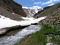
The northern slopes of the Sesang Peaks drop to the bottom of the Sesang River Valley (3450 m). In many places on these slopes you will find rocky areas and glacially carved cirques that house large snow fields (PIC 1, PIC 2). This is most notable below the summits of #2, #3 & #4. Traversing the ridge top from #2 to #4 seem to involve much rock climbing (I have not done this). Sesang #1 however, which is the tallest peak in the group, can be easily climbed via its northern slopes without any technical difficulties.
The southern slopes of the Sesang Peaks drop down to the bottom of the Deev Asiyab River Valley (3200-3300 m). Walls can be found on these slopes just below many of the summits including Sesang #1 (PIC 1). To the east, Sesang #5 is connected to the 3994 m Vararoo (Cheshmeh Kala) Peak and to the west, Sesang #1 is separated from the 4260 m Chapakro Peak via a 3990 m saddle.
Climbing the Sesang Peaks require a multi-day hiking program. The usual starting point is the village of Nomar (2150 m) to the northeast. On day one, you will hike to the banks of the Sesang River to set up your base camp and then go on to climb the Sesang and other nearby peaks during the next few days (one way distance to the top of Sesang #1 is 20 Km). Another approach from the Lar Reservoir to the southeast has also been described (this however will probably require you to traverse the rocky areas between #4 and #2).
From the summit of Sesang #1 you will have great views of many of the nearby peaks. The most impressive view will of course be that of the massive cone of Mt. Damavand to the southeast
Getting There
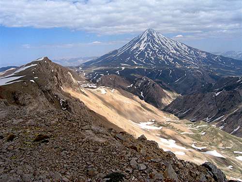 Damavand 5671 m & Sesang #2 4130 m
Red Tape
No fees/permits.Camping
Anywhere.Add External Links text here.