
-
 17397 Hits
-
 85.36% Score
-
 20 Votes
|
|
Mountain/Rock |
|---|---|
|
|
42.89720°N / 0.7422°W |
|
|
Hiking, Mountaineering |
|
|
Spring, Summer, Fall, Winter |
|
|
7749 ft / 2362 m |
|
|
Overview
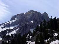
 Mallo de Acherito
Acherito is one of the most classical winter climbings of valley of Belagua/Ansó and it's a beautiful mountain for its characteristic conic shape. There might be thought that this mountain was a little minimized by its higher companions of this great calcareous massif, but it's not like that, since it possesses in winter a nice and steep totally smooth and unpolluted ramp of snow that attracts the mountaineers for generations.
Othe name in the maps: Mallo Acherito.
The normal route has trailhead in the mountain hut of Linza.
 |  |  |  |  |
Getting There
For approach to Linza see the pages of mountains of the zone: Mesa de los tres Reyes and Petrechema.Red Tape
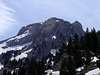
 Mallo de Acherito
No permits required.
The parking of mountain hut of Linza is small for the many mountaineers that come here on a sunny day for what it is advisable to get up early (or to sleep in the mountain hut the previous day). Linza is the point of beggining of many routes for others mountains of the zone.
 |  |
When To Climb
 Mallo de Acherito
All the year.
In winter is neccesary crampons and ice-axe. A lot of cold days the ice is dangerous in the final ramp.
In summer it is indispensable to take water in the karts, solar protection and cap (the karst is very arid). Also something of impermeable clothes for if it rains.
 |  |  |  |
Valleys of Belagua and Ansó
The zone has the first elevations of consideration of the Pyrenees like Anie (2507m), Mesa de los Tres Reyes (2444m), Petrechema (2377m), Chinebral de Gamueta (2329m), Lapakiza (2100m), Gorreta de los Gabachos (2272m), Anzotiello (2221m), Quimboa Alto (2186m), Petraficha (2188m) or Chipeta Alto (2189m). |
Camping
See the pages:*Mesa de los tres Reyes
*Petrechema.
Mountain Conditions

The storms in the evening are very frequent in the Pyrenees specially in july-august.
Information:
Meteo-France
National Institute of Metereology of Spain (see province of Huesca in the north)
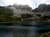
Ibón de Acherito
 Ibon de Acherito
In the east side of this mountain is the second ibon of Pyrenees, from the west, the Ibón de Acherito, a marvel little lake at 1860 meters surronded of peaks. The Ibons of Pyrenees are lakes of origin glacier of those who exist more than 1000 in this mountainous chain. The route to climb the Ibon is not the same that for this peak since there's a ravine (the barranco de Acherito) that separates the summit and the lake, for what it is not the most direct option and needs an own approximation to enjoy this natural marvel. Generally it's climbed from Guarrinza/La Mina (see route of Barranco de Acherito) near the selva de Oza in the valley of Echo.
 |
 |
 |
 |
Views from the summit
Some of pictures about the great landscape (this summits of this area like Acherito, Chinebral, Petrechema... are marvel wachtowers for the first great peaks of Pyrenees) | 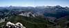 |  |
External Links
- Wallpapers
Pictures for wallpapers for the zone of Acherito.
- FEDME
Federación Española de Deportes de Montaña y Escalada (Spanish Federation of Sports of Mountain and Climbing).
- Ibon de Acherito
nice pictures of route of Lake of Acherito (text in spanish)