
-
 8127 Hits
-
 74.01% Score
-
 4 Votes
|
|
Mountain/Rock |
|---|---|
|
|
49.12600°N / 20.08200°E |
|
|
7250 ft / 2210 m |
|
|
Overview
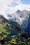
Široká / Szeroka Jaworzyńska is the last “2000meters” summit of a long (about 7 km) lateral ridge detached on Malý Javorový Štít in the north direction and containing Javorové Veže / Jaworowe Turnie, Javorové Vrchy / Jaworowe Wierchy and Široká with its the north-west and the north-east ridges. On account of its location “before” the main ridge of High Tatra a view from the top is excellent, especially on L’adové Š&t#237t massif and surrounding of Javorová and Bielovodská Valley.
It is interesting for botanist, too. Its the highest parts (south) are built from granite, but the north slops are from limestone, so on Široká you can find plants characteristic for granite High Tatra and calcareous Western or Belanské Tatra. For that reason TANAP (Tatranský Narodný Park – National Park of Tatra) create here a close nature reserve.
There are already some interesting caves, with the one of the most beautiful “aquatic” cave in Tatra Mountains - “Mokrá Diera”. For climbers there are no interesting routs.

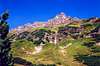
Široká and Belanske Tatry in background
Široká is separated in the south direction from Štít nad Zelenym / Zielona Czuba in Jaworowe Wierchy ridge by Široké Sedlo / Szeroka Przełęcz, in the north-west direction from Zámky / Spismichałowa Czuba by Sedlo nad Zámkami / Niżna Szeroka Przełęcz and in the north-east from Vel’ký Baboš / Suchy Wierch Jaworowy by Suché Sedlo / Sucha Przełęcz Jaworowa. It ascends over Javorová (on the west) and Bielovodská (on the east) Valley, exactly their branches: Litvorový Žl’ab / Litworowy Żleb (on the south-east), Široká / Szeroka Valley (on the north-east) and Zelená Javorová / Zielona Jaworowa Valley (on the west).
Of old this area was a pastoral area of villages of so called Niedzickie Country. In 1879 year Prussian prince Christian Hohenlohe bought this area (the whole Javorová Valley with a part of Belanske Tatra) and created a big private zoo for hunting. This zoo was walled by a high wooden (till upper limit of forest) and wire (higher) fence and was guarded by a numerous guards, so called “jegr”, coming from Tirol. Except an indigenous fauna (mountain goats, roe-deers, bears, lynxs) there were raised imported tiers like deers from Caucasus or America, Capricorns from Alps or bisons. They were fatten in winter, but within the zoo they could move free. The prince arrange here hunt very often. For tourists this area was closed except two trails – like today. After the First World War his successor sold this area for Czechoslovakia and since 1949 it is a part of National Park of Tatra.
The name of Široká comes from the large north-east slope falling down to Široká Valley and means “wide”. The Polish name locate additional this summit over Javorová Valley
 |  |  |  |  |
Summit view
If you have photo from the top, put it here!
 |  |
Getting There
FROM SLOVAKIAN SIDE:
The major city in this area is Poprad, where you can get by bus or train. From Poprad there is a lot of buses and trains to Starý Smokovec (13km) at the foot of Tatra:
train time table
bus time table
train time table from Poprad to Starý Smokovec Tatranská elektrická železnica
Maps of Starý Smokovec and Tatranská Lomnica
From Starý Smokovec take a bus to Tatranská Javorina Pošta or Tatranská Javorina - Lysá Pol’ana (time table).
FROM POLISH SIDE:
The best point to stars the journey is Zakopane – the biggest town on Polish side of Tatra Mountains. You can get there from Kraków by bus (most recommended), car or train:
By bus: there are a lot of buses from Kraków to Zakopane - time table of PKS and private lines Frey and Szwagropol.
By train: the road is much longer and dearer than by bus - time table from Kraków 0.00-11.59 a.m., 12.00-11.59 p.m. and from Zakopane.
By car: from Kraków take a road number 7 to Chyżne and follow it to Rabka. Here this road turn right to Chyżne, but you follow still straight a head in south direction by road number 95. In Poronin 5 km before Zakopane turn left (east) to border crossing point in Łysa Polana.
From Zakopane: Take a bus to Polana Palenica (time table of PKS, in high season there are a lot of private buses, too – a station is opposite to PKS) and get off in Łysa Polana / Lysá Pol’ana (Attention! private buses sometimes has a direction-board “Morskie Oko”). Cross the polish-slovakian border .
If you want reach Široká from Javorová Valley take a bus to Poprad, which goes through Tatranská Javorina (time table). Bus station on Slovakian side is about 100m after border crossing point on the right. Or you can go on foot (it is about 4 km).
 |  |  |  |
Maps

Map of Široká' area
Tatry Wysokie, in scale 1:25 000, description in 6 languages, ISBN 83-87873-26-8, available in all shops in Zakopane. Here you can look at net version.
A high quality maps in scales 1:25 000 and 1:50 000 are produced VKU Harmanec, too. They are available at all chalets and shops in cities under Vysoke Tatry.
When To Climb
You can climb Široká the whole year. But if you don’t want to have problems with park-guards climb when there is snow (November-April).
Red Tape
The “High Tatra” is a National park, UN Bioheritage area and a European BioHeritage. Široká area is additional a close nature reserve. So it is impossible to visit it legally (with a guide, too). Only in winter time Slovakian nature-guards turn a blind eye to regulations and it is possible to visit it, but it is still illegally!
Additional in winter time (from November the 1st – June the 15th) The Tatra Mountains in Slovakian part are closed for normal tourists (not for members of any climbing club). Foresters from lodges which are by mouth of Javorová and Belovodská Valley can check your membership to such a club.
For more informations look at High Tatra/Vysoke Tatry GROUP page.
For climbing regulations look at Gerlachovsky Stit page.
Accomodation
There is no chalet near by Široká, but you can find pensions and rooms in Tatranská Javorina and in Ždziar: accommodation. But most of them have no webpage!
Absolutely no camping is permitted in the nature park. The nearest camping in Polish side is in Zakopane:
1. Camping pod Krokwią, 34-500 Zakopane Żeromskiego Str., phone/fax: + 48-18-201-22-56, email: camp@podkrokwia.pl
2. Camping KS SN PTT-1907, 34-500 Zakopane Za Strugiem 39 Str., phone/fax:+48-18-201-55-12
3. Camping Harenda, 34-500 Zakopane oś. Harenda 51b, phone/fax: +48-18-20-147-00
The nearest camping in Slovakian side is in Stara Lesna and Tatranska Lomnica.
Mountain Conditions
Web forecast:
situation at this moment and forecast
Information of avalanche danger:
TOPR (in English) and HZS
Rescue:
On Slovakian side acts HZS (Horska Zachranna Sluzba)
Starý Smokovec 23, 059 60 Vysoké Tatry
phon.: 052/4422820, fax: 052/4422855,
mobil: 0903624869
e-mail: vtatry@hzs.sk
www.hzs.sk