

-
 42702 Hits
-
 92.85% Score
-
 40 Votes
|
|
Area/Range |
|---|---|
|
|
46.57110°N / 12.28130°E |
|
|
Hiking, Trad Climbing, Via Ferrata |
|
|
Summer |
|
|
9314 ft / 2839 m |
|
|
Overview
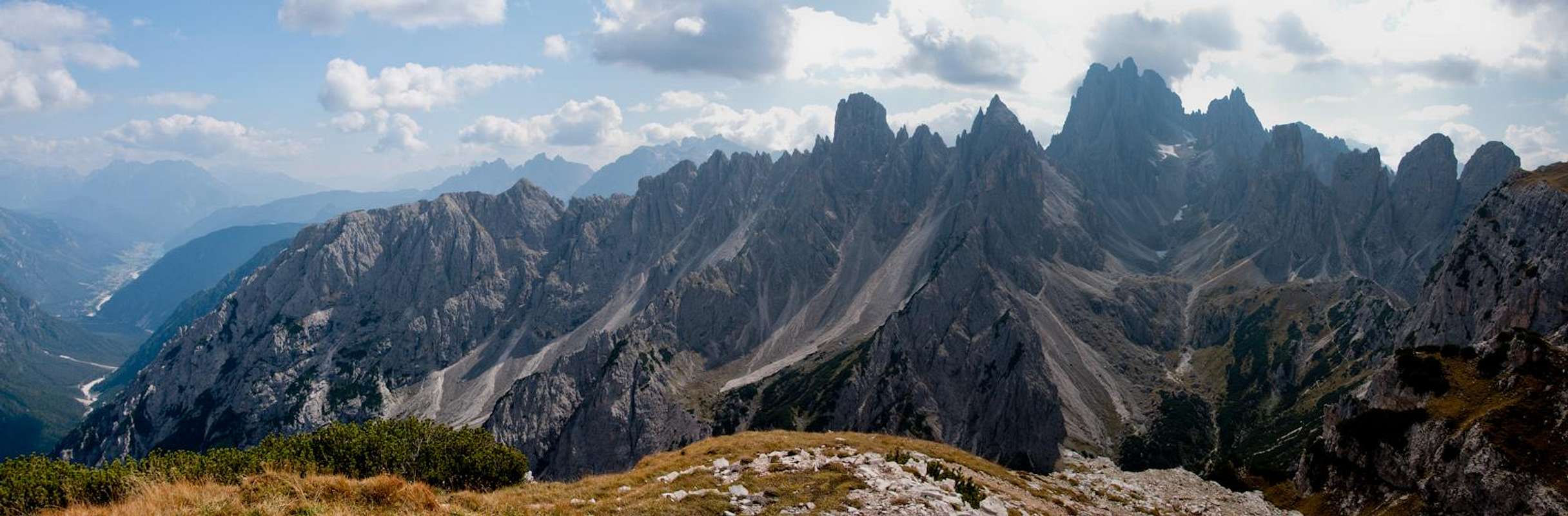
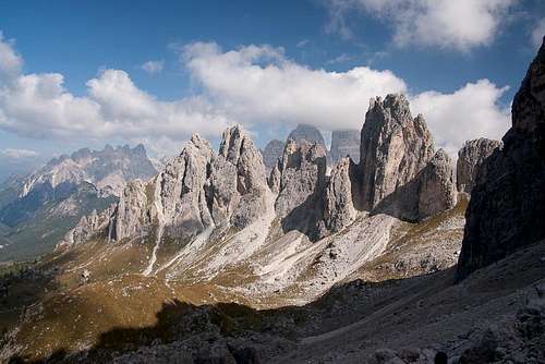
 The Cadini di Misurina seen from the south The Cadini di Misurina seen from the south |
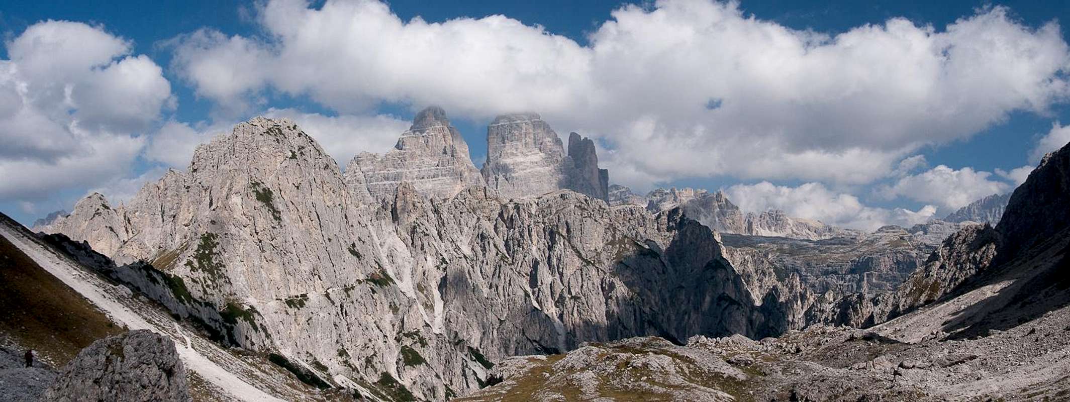
East of Cortina d'Ampezzo, east of Cristallo-Popena group, between the Sorapiss (S) and the Lavaredo (N), this fine group, full of pinnacles and passes, fantastic for hiking (less for climbing) , is named after the basins surrounding the sharp edges that rise from fine meadows and woods on the outside and from big "ghiaioni" (scree slopes) on the inside.
Its borders are :
South : the Ansiei valley (Auronzo di Cadore)
West : the Misurina lake
North : the Lavaredo group
East : the Val Marzòn (ending with the Vallone di Lavaredo)
You can hike almost everywhere in the basins (cadini) , passes are normally not difficult, careful in case of snow or iced snow,
at the beginning of the season an iceaxe could be useful.
Better carry in the backpack a hiking rope (ferrata's gear is almost useless)
Climbing routes are not long (normally 150-300 m) and the rock is not always fine.
This group is complex, so the only way to understand how to move here is using a good map and studying well the hike before starting.
Cadini are made of these Subgroups : (here named Rami = branches)
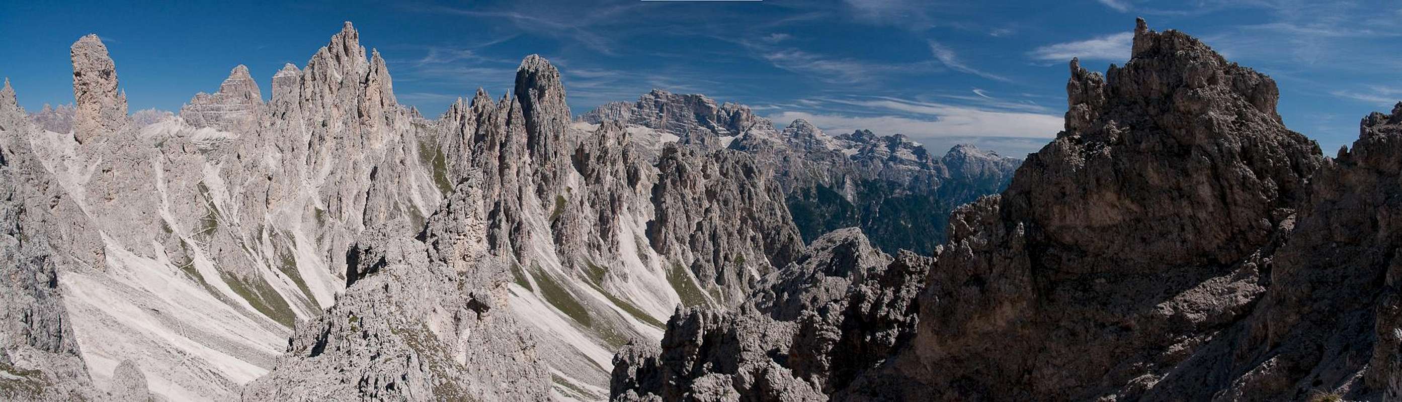
 schematic map schematic map |  labeled pic labeled pic |
Getting There
  |
Many different ways to get here :
From Veneto
- Take motorway A27 from Venezia (Venice) to Ponte nelle Alpi
- Take SS51 (Alemagna) to Cortina d'Ampezzo
- Take SR48 across Passo Tre Croci
- Turn left on SP49 to Misurina Lake
- Park near the cable-car at the southern end of the lake or take the toll road to Rif. Auronzo from the northern end
From Südtirol / Alto Adige
- Take Brenner motorway A22 to Bressanone (Brixen)
- Take SS49 through Val Pusteria (Pustertal) until you reach Dobbiaco (Toblach)
- Turn south onto SS51 to Cortina d'Ampezzo.
- At Carbonin (Schluderbach) turn left onto SS48bis to Misurina.
From Trentino
- Take Brenner motorway A22 to Trento
- Take SS621 or SP71 into Val di Fassa
- Take SS48 across Passo Pordoi to Arabba
- Stay on SS48 and drive across Passo Falzarego to Cortina
- Take SR48 across Passo Tre Croci
- Turn left on SP49 to Misurina Lake
Moving in Cortina basin can be a gamble ... a lot of traffic but :
wherever you are in Cortina bus services allow you to get the Tre Croci Pass with a regular, cheap and comfortable summer and winter service.
here from you can get the seasonaly updated pdf (acrobat) files
simple comparison table of difficulties
| UIAA | French | USA |
| 1° | F | 2 |
| 2° | PD | 3 - 4 |
| 3°inf - 3° - 3° sup | AD | 5 - 5.2 |
| 4° inf - 4° - 4° sup | D | 5.3 - 5.5 |
| 5° inf - 5° - 5° sup | TD | 5.6 - 5.8 |
| 6° inf - 6° - 6° sup | ED | 5.9 - 5.11 |
| 7° | EX | 5.11a - 5.11b |
Ramo di Misurina
 Cima Cadin de Misurina, Cima Cadin della Neve, Cime Cadin di Maraia
The westernmost subgroup
Between the Misurina slopes (W) and the Cadin della Neve (E)
this is the subgroup with the most comfortable access, using the chair lift to Col de Varda (refuge)
Main summits (from S to N)
main routes :
- NW wall - Comici - 200m - 3° (1 pitch 5°) - amusing
- NW wall - Quinz - 5° inf
- S wall - Mazzorana - 180m - 4°
- N edge - 4°
main routes :
- West wall - Eötvös - 350m - 3°
- West wall - Angelini - 350m - 2°
- West wall - Mazzorana - 350m - 4°
- N ridge - descent route - 2°
main routes :
- East wall - Mazzorana - 4°
- East wall - crack - 3°
- West wall - Mazzorana - 4° (1 pitch 5°)
Minor summits
all these summits, even the minor ones have fine middle difficulty routes
 Forcella di Misurina
North of Gusela de la Neve (a fine pinnacle on the northern branch of the ridge) the
"Forcella di Misurina", crossed by the sentiero Bonacossa, a fine "ferrata"
Ramo della Neve
 Cime Cadin de Maraia, Cima Cadin della Neve, Cima Cadin di Misurina
The southernmost subgroup
Between the Grave di Pogoffa (S) and the Cadin della Neve (N)
just behind the previous subgroup when coming from Col de Varda
Main summits
main routes :
- from Forcella di Pogoffa along the ridge (Innerkofler) - 2°
- from Forcella di Pogoffa west wall - 2°
- from Grave di Pogoffa (South) - CApuis-Angelini - 3°-4°
main routes :
- NW wall to Campanile - Mazzorana - 4°
- NE wall to Campanile - Quinz - 4°sup
- NE side - Baldi - 280m 4°
from campanile an easy climb leads to the Cima
Minor summits
all these summits, have middle difficulty routes
Ramo di San Lucano
 Cima Cadin di Nord-Ovest, Cima Eötvös, Cima Cadin di San Lucano
 Between the Cadino del Nevaio (NW) and the Pian di Mussa (SE)
Accesses from Rifugio Fonda Savio and from Rifugio Città di Carpi
This is the most important branch and here the higher summits of the group and some of the best climbing routes of the group
Main summits
- S wall - Casara - 3°
- ferrata Merlone - (West pillar) - exposed but safe - beware of falling stones moved by hikers
- E wall .Crepaz - 400m - 4°
main routes :
- SW wall - Oppel - 500m - 4°
- N wall - Corsi - 200m - 4° inf
main routes :
- N edge - Maraini - 4° (fine)
- SE ridge - Crepaz - 500m - 4° inf
main routes :
- S edge - Dülfer - 270m - 5°
- SE wall - Crepaz - 250m - 5°inf
main routes :
- S edge - Castiglioni - 4°
- E wall to S summit - Crepaz - 5°sup
"minor" but important pinnacles :
The 2 passes delimiting the branch (Forcella del Nevaio on the W side and Forcella della Torre on the E side)
are crossed by two on the most amazing hikings trails in this area
 |  |
Ramo del Nevaio
 Cima Cadin Nord Ovest
Between the Cadin del Nevaio and Cadin dei Tocci, divided from S.Lucano by the Forcella (pass) del Nevaio and
from Ramo del Diavolo by the Forcella (pass) del Diavolo
Accesses from Rifugio Fonda Savio and from Rifugio Città di Carpi
Main summits
the 2 northern summits : Pianoro dei Tocci 2675 m and Castello Incantato
make, together,a fine wall with some fine routes easy or very hard and quickly accessed from Rifugio Fonda Savio
Ramo di Croda Liscia
 |
The easternmost subgroup, east of Ramo di San Lucano,
Between the Cadin Deserto (S) and the Val Campedelle (N)
Divided from Ramo di San Lucano by the Forcella della Torre
access from Rifugio Città di Carpi
Main summits
main routes :
- N edge - Castiglioni - up to 5°
- NW wall - Comici - 250m - 3° sup
- S wall - Crepaz - 300 - 4° inf - the finest
Ramo del Diavolo
 Forcella di Diavolo
Due to the hiking importance of the Forcella del Diavolo this is considered as a subgroup and not a part of Ramo del Nevaio
accesses from Rifugio Fonda Savio and from Rifugio Città di Carpi
This branch is the most known for its wonderful triptic of pinnacles :
Torre Leo - Torre del Diavolo and il Gobbo
and here you can find the most difficult and spectacular climbs of the whole group
Main summits
 |  |  |
Ramo dei Tocci
 Cime Cadin dei Tocci
Between the Cadin dei Tocci (SW) and Cadin di Rinbianco (NE), this subgroup is to be considered as the central subgroup (and the most frequented)
Access from Rifugio Fonda Savio
 Looking out from Forcella della Torre
Here the most climbed summit of the whole group :
other important summit is the
Ramo del Rimbianco
 |
Between the Cadin di Rinbianco (W), the Val Campedelle (S) and the Vallone di Lavaredo (NE) this is the most hikeable subgroup, it allows the best access (on foot) to Rifugio Auronzo.
This is the branch with the most panoramic (and easy) hiking area of the group, containing the final section of the sentiero Bonacossa
Main summits
 |  |  |
Ramo di Campoduro
 Croda di Campoduro in front of the Marmarole Group
The ending ridge toward SE, good panoramic point, almost without climbing and hiking interest
the only summit worth to be pointed out is the
Croda di Campoduro 2244 m
Accomodations
 Rifugio Fonda Savio
Rifugio Fonda Savio (2359 m) (tel 0435 39036)
fastest access from the road to Rif. Auronzo, some hundred meters after the fork to Monte Piana follow a small road (115)
till Pian degli Spiriti (~1900 m - car parking possibilities)
- a comfortable walk on good path takes you in less than 2 hours to the refuge
Capanna Col di Varda (2115 m) (tel 0435 39041)
Starting point is at the southern limit of Misurina Lake :
- using chair lift in few minutes directly to the refuge
- on foot, along the ski run, in about 1 hour
Rifugio Città di Carpi (2110m) (tel 0435 39139)
from capanna Col di Varda with a panoramic fine walk on a fine path in less than 2 hours (photo shot stops included)
When to Hike and Climb
summer : late june -september |  |  |  |
Maps and Books
strongly recommended here !!!Tabacco 1:25.000 - sheet 03 - Cortina D'Ampezzo e Dolomiti Ampezzane : complete and absolutey the best !
Kompass 1:50.000 - sheet 55 - Cortina d'Ampezzo - easy use
Best book here (the most complete) is the CAI-TCI Guida dei Monti d'Italia - Dolomiti Orientali II
- in Italian and perhaps not so easy to use,
but containing a lot of info about all : paths, hiking, climbs, history ... not so fine for ferratas
Weather
 Typical August conditions in the Cadini :-)
I've spent here, in different years, 3 climbing days and 3 hiking days (with my family) and, maybe I've been unlucky but ... they were all raining days :(
External Links
- cadini Group
a fine photo - page
DANix - Jul 28, 2009 6:28 pm - Hasn't voted
Classic Dolomite Climbs Campanile Dulfer Route ErrorsIt is almost certain that the authors of Classic Dolomite Climbs, Kohler and Memmel, have not climbed the East Rib of the Campanile Dulfer. Their topo and route description contains several errors: the second pitch is 25m, a III, and should end after the minor down climb; the last pitch is the mental crux and is poorly protected. In between the two, the route can go most anywhere, just aim for the lunch ledge at the base of the tower proper and run full-length pitches. We found no fixed anchors. What is most distressing, and the reason why I am writing, is the egregious errors in the descent description. One cannot down climb from the top of the tower to the 10m rap station. 60-70m twin ropes are needed to bypass the 10m rap station and should be used, otherwise take a bolt kit since the 10m is a horror, two flexing rusty pitons (surely Dulfer vintage) with no way to back up the anchor. These are close to pulling and will kill everyone attached to the anchor. Once down in the bowels of the chimney, use the second double piton anchor and the third to rappel down to the obvious pedestal. The notch anchor doesn’t exist. Climb up the pedestal and descent the step gully to it’s end where begins a series of 10-40m rappels that eventually take one back to the base of the climb. These anchors are OK. Kohler and Memmel’s descent description is a bit of a wonder after the pedestal. From what we could tell, a rising traverse II-III would be needed to reach anything resembling a huge chockstone in the gully. Lastly, make sure no one is descending after your party since loose rocks rain down the length of the gully near every time one pulls their ropes. Regardless of the poor topo and route description, the Dulfer route is quite spectacular.