
-
 10258 Hits
-
 88.51% Score
-
 27 Votes
|
|
Mountain/Rock |
|---|---|
|
|
43.55601°N / 122.13123°W |
|
|
Lane |
|
|
Scrambling |
|
|
Summer, Fall |
|
|
7138 ft / 2176 m |
|
|
The Mountain.

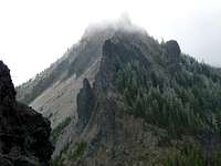

South Mt Yoran is an old eroded shield volcano. All that is left of the original mountain is the the resistant vent plug. It is primarily made up of basaltic andesite and is approximatly 400,000 years old. A long with Its sister mountain Mt yoran a quarter mile to the west make up the dominant Geologic feature of the north Diamond peak wilderness area.
The two Yorans peaks along with the Divide basin and pass make up a picturesque alpine environment just north of the diamond peak complex. The basin holds Divide lake which lies along the west flanks of both Mt yoran and south Mt Yoran. The basin is the head of a glacial trough that divides Diamond peak from the yoran complex hence the name. The views from south Mt Yoran extend north to the three sisters volcanic complex into the forested canyons of the western cascades, east towards the cascade high country and central Oregon and south upon Diamond peak and Its many sub summits and spires.
An overview of the climbing routes are as follows
1.)The south ridge-classII scramble from divide pass.
2.)west side gullys class-II-III scree scramble up in to the gulleys. With some class four moves on the summit block.
Getting There
Driving in from the willamette valley you will exit I-5 at mile post 188 Highway 58 willamette hwy towards central oregon / klamath falls. Then drive 36 miles to the town of oakridge where you can top off the gas tank and pick up any supplies needed as this is the last town on the route.Continue thru Oakridge on the east end of town you will exit at mile post 38 left towards hills creek resevior. At seven tenths of a mile you will come to a junction stay to the left accessing hills creek road #23. Then follow road # 23 for twenty miles till you arrive at the vivian lake trail head. There are good views of Diamond peak from here.
The route from the trailhead initially heads northeast for eight tenths of a mile till it reaches Notch lake. (There is a Diamond peak tie trail half way to Notch lake off to the right do not take this trail.) Then just beyond Notch lake the trail splits. The left fork goes on towards vivian lake. Take the trail to the right the Mt yoran trail.
Follow the Mount Yoran trail for 3.2 miles. The trail climbs steadily through the forest for a mile and a half until it reaches a bluff at 6.745 ft. from here the trail follows along the rim of a forested basin with good views of Diamond peak. Another mile and seven tenths later you arrive at the flanks of the Two Mt yorans and Divide lake.