
|
|
Mountain/Rock |
|---|---|
|
|
39.67906°N / 105.49281°W |
|
|
Clear Creek |
|
|
Hiking |
|
|
Spring, Summer, Fall, Winter |
|
|
11486 ft / 3501 m |
|
|
Overview
Mestaa'ėhehe Mountain (formerly Squaw Mountain) is the eastern most of the peaks that are on a northeast arm of Mount Evans. The name was changed on December 9th, 2021. Mestaa'ėhehe Mountain is located wholly within Arapaho National Forest, just south of the Echo Mountain Ski Area on CO 103 Mestaa'Ėhehe Road (Formerly Squaw Pass Road).
Located in the Front Range of the Colorado Rocky Mountains, it is easily accessible from the Denver metropolitan area. It can easily be combined with Chief Mountain 11,709' just 1.6 miles to the west.
Its summit is a ridge that runs southeast to northwest for about a half mile. Along this ridge line there are three separate "summits", with the southeastern one, which has the lookout tower on it, the highest of the three summits. The two "summits" without the lookout tower allow some rock scrambling opportunities. At the summit, there is an array of communication towers, plus a two story stone lookout tower. The lookout tower was closed to the public as of July 2022. However, the summit itself still has excellent views.
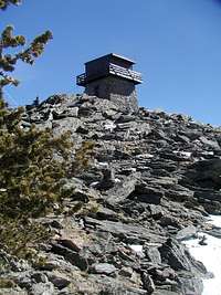 There are stairs on the outside that one can climb to get to the viewing balcony
Getting There
Mestaa'ėhehe Mountain is located just south of the revitalized Echo Mountain Ski Area on the CO 103 Road. To get there from Denver, head west on I-70 to the Evergreen Parkway exit (exit 252) and head south and west to the 4th stoplight where you turn right onto the CO 103. From there the road to the summit is accessed after driving 12 miles along a twisty road. Another option is to take I-70 to exit 240 in Idaho Springs and head south up the Chicago Creek valley, passing the turn off to the Mount Evans Road at Echo Lake and continuing another several miles to the start of the forest road to the summit. This route is longer than the previously mentioned route if coming from the east.
Finally, another option in Idaho Springs is to take the Soda Creek Road to the 151 Road that winds up towards CO 103. The 151 road is good dirt. Once at CO 103 turn right and its just a few minutes to the forest road.
There is plenty of parking along the forest road that heads towards Mestaa'ėhehe Mountain, however do not block the forest road. The forest road starts at about 10,650' and there are a couple parking spots. The road itself is a bit rough if you want to go up further.
Hiking up Mestaa'ėhehe Mountain
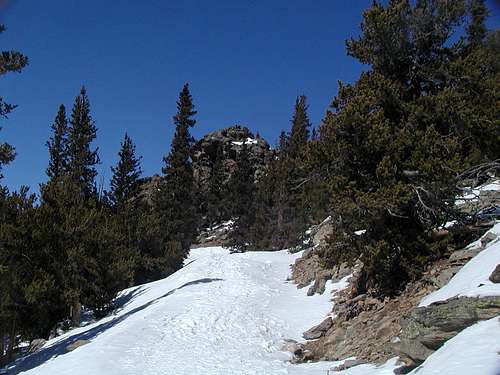
The easiest route up Mestaa'ėhehe Mountain is an easy hike up an gravel service road that reaches all the way to the summit. It is about a 2 mile hike from the parking area on CO 103 to the summit. The first half mile or so of the hike is heading southeast up to the saddle between Mestaa'ėhehe Mountain, to the east, and Papoose Mountain to the west. From the saddle head east along the road to the summit. There are a couple of switchbacks after the saddle. Looking up from the second to last switchback along the trail one is looking at one of the rocky summits along the summit ridge.
Red Tape
Mestaa'ėhehe Mountain lies within the Arapaho National Forest. There are no permits or fees necessary. There does appear to be some private land along CO 103 so please respect the landowners privacy and stay on the trails and/or unimproved roads near the highway. Dogs must be on a hand held leash no longer than six feet at all times. In Colorado dogs who chase either livestock or wildlife can be shot. And please don't let your dog defecate on the trail and leave it there - pick up after your pet. During deer and elk hunting season, generally late October to mid November, it is advisable to hike with some hunter orange.
Camping
There are no developed campgrounds nearby, however camping is allowed anywhere within the Arapaho National Forest with the following restrictions, no camping within 100 feet of all lakes, streams and developed trails.