
|
|
Mountain/Rock |
|---|---|
|
|
39.53530°N / 106.2595°W |
|
|
Eagle/Summit |
|
|
Hiking, Mountaineering, Trad Climbing, Toprope, Scrambling, Skiing |
|
|
Spring, Summer, Fall, Winter |
|
|
11888 ft / 3623 m |
|
|
Overview
Shrine Mountain is a well known, but unranked peak in the southern section of the Gore Range in Colorado. The mountain was named for its excellent view of Mount of the Holy Cross.The mountain has easy year round access, which makes it a popular destination. In summer, the mountain is well known for wildflowers and in winter the mountain is well known for skiing.
Near the mountain is also the Shine Mountain Inn, which actually consists of three different cabins, Walters, Chucks, and Jays, which are open year round and are popular with mountain bikers and hikers in the summer and skiers and snowshoers in the winter.
Shrine Mountain has a different geology than most of the rest of the Gore Range. There are several outcrops of sandstone and conglomerate which is a deep red color and for which rock formations the mountain is known for, adding to the scenic beauty of the area.
The highest summit of the mountain is an easy climb, but the outcrops provide good rock climbing in the 4th and 5th class ranges and are rather solid for the rock type. The outcrops are just lower than the main summit and are on the east face of the mountain.
South of Shrine Mountain is the Wingle Ridge of which is the “parent peak” from Shrine Mountain.
From the summit of Shrine Mountain, you get a great view of the rugged central Gore Range Peaks to the north, and Mount of the Holy Cross to the west. To the east is the Tenmile Range and to the north, the long snake like and gentle Wingle Ridge.
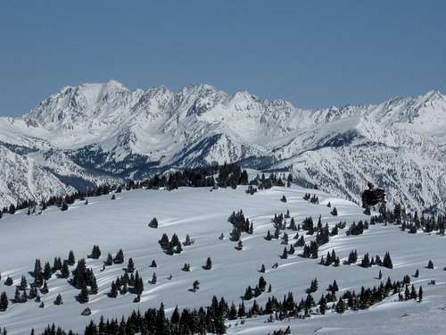 Shrine Mountain in the foreground and the Gore Range as seen from the Wingle Ridge.
Getting There
Winter-Vail Pass TrailheadThe Vail Pass Trailhead is along I-70 5.4 miles west of Copper Mountain Ski Resort or 14.3 miles east of Vail. Take Exit 190 and park at the indicated overnight parking area.
The Shrine Pass Road and the trail to the Shrine Mountain Inn Cabins (which are on the way to the mountain) leaves from the parking area. It is well signposted.
Make sure to have a winter recreation pass (see the Red Tape section below).
 Snowshoeing back to Vail Pass from the Shrine Mountain. This is not far from the winter trailhead.
Winter-Red Cliff Trailhead
If driving from the north, the the I-70 exit at Minturn which is 5.4 miles west of Vail. Drive 10.3 miles south along Highway 24 to the Turkey Canyon Bridge.
If driving from the south, drive north from Leadville from the junction of Highway 24 and SH 91 for 22.6 miles.
Once at the Turkey Canyon Bridge, drive east to Red Cliff. Find the Shrine Pass Road, a.k.a. County Road 16 and park along this road or near the marshal's office.
Summer-Shrine Pass Trailhead
In summer, you can actually drive to Shrine Pass, just north of the mountain. Condsider taking a mountain bike to make the route more challenging.
From the Vail Pass Parking area as described above, take the marked road towards Shrine Pass. The road is typically described as a 4wd road, but sometimes the road is in good enough condition for high clearance 2wd vehicles.
Routes Overview
Because the routes are different on the mountain, depending on the season, a summary of routes during the two main seasons will be outlined below.WINTER
Shrine Mountain Winter Route via Vail Pass
Because I have only climbed Shrine Mountain in the winter season and from this route, this is the route that will have a route page (both Shrine Mountain and Wingle Ridge will be included on a single route page).
This is a straight forward climb in the winter. For Shrine Mountain, the route is about 7-8 miles round trip (depending on variations) with about 1300 feet elevation gain. The climb can be done in one day, but many people stay in the Shrine Mountain Inn cabins for a night.
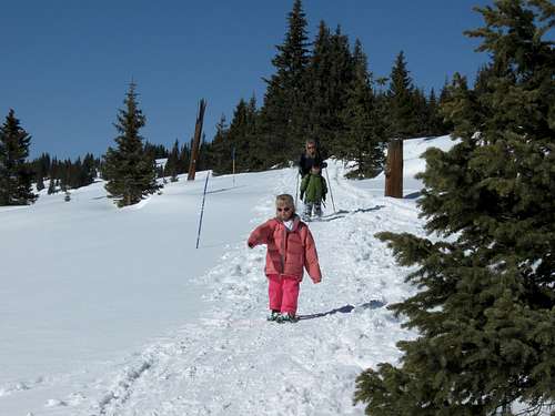
 Shaylee and Kessler near the summit of Shrine Mountain on December 1 2012.
Shrine Mountain Winter Route via Red Cliff
A much more challenging route to Shrine Mountain in winter is from the Red Cliff Trailhead, which also accesses the mountain from near Shrine Pass. This route is just over 20 miles round trip and should be considered a two day climb while spending the night at one of the Shrine Mountain Inn Cabins (see below).
SUMMER
In summer, Shrine Mountain is just a short climb (maybe too short for some!) from Shrine Pass. A marked trail reaches the summit of Shrine Mountain from the pass. Click HERE for a description of the trail as written by the Forest Service.
For some more adventure, good but short (1 pitch) rock climbing routes can be made up the outcrops at any time of year.
Red Tape
Between the day before Thanksgiving (late November) through April, you must have a pass for the Vail Pass Winter Recreation Area. If you book a hut at one of the Shrine Mountain Inn huts, this fee will be included in your reservation (and must be displayed on the windshield).If you didn't book a hut, you must buy a pass separately. The $6.00 per person per day/night, and children 13 and under are free.
Click Here for more/updated information.
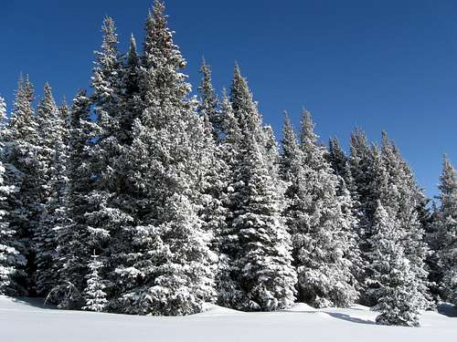 Frosted trees near Shrine Mountain. Make sure to have a Vail Pass Winter Recreation Area pass if visiting in winter.
In summer, standard forest Service rules apply and make sure to practice Leave No Trace principles.
When to Climb
Shrine Mountain has easy access year round.One of the best times to climb the mountain is in winter. In winter, with good route selection and route finding, avalanche danger can usually be avoided (but is certainly present if you don't select a good route!). Spring usually has heavy snow as well.
In summer, the area is well know for wildflowers.
In fall, take extra care during hunting season and wear blaze orange if you head out here at that time of year.
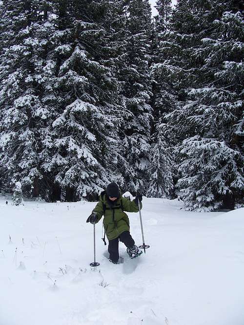 Breaking Trail in November.
Camping and Huts
In summer, dispersed Camping is allowed along the Shrine Mountain Road.In winter, most people stay in the Shrine Mountain Inn (Walters, Jays, and Chucks Cabins).
See below for links on the cabins and how to book them through the 10th Mountain Division Hut Association:
10th Mountain Division Hut Association
Shrine Mountain Inn Huts
 Walters Cabin with the Gore Range looming in the background.
Mountain Conditions
For current trail and snow conditions, more information, and access issues contact:White River
National Forest
900 Grand Ave.
Glenwood Springs CO 81601
970-945-2521
CLICK HERE FOR WEATHER FORECAST
Weather and climate data for the Climax Station at 11,360 feet elevation is below. *National Weather Service Data 1949-2005. The Climax Station is just lower than summit of the mountain and will give one a good idea of typical climate conditions in the area, though the area around Vail Pass usually gets more snowfall.
| MONTH | AVE HIGH | AVE LOW | REC HIGH | REC LOW | AVE PRECIP (in) | AVE SNOW (in) |
| JAN | 25 | 2 | 50 | -33 | 2.14 | 39.9 |
| FEB | 27 | 3 | 53 | -28 | 1.81 | 35.1 |
| MAR | 32 | 7 | 57 | -24 | 2.26 | 39.9 |
| APR | 38 | 13 | 59 | -20 | 2.48 | 39.6 |
| MAY | 48 | 24 | 71 | 0 | 1.88 | 19.4 |
| JUN | 58 | 33 | 75 | 10 | 1.31 | 4.9 |
| JUL | 65 | 39 | 79 | 12 | 2.24 | 0.1 |
| AUG | 62 | 38 | 76 | 18 | 2.22 | 0.2 |
| SEP | 56 | 31 | 74 | 6 | 1.56 | 5.7 |
| OCT | 46 | 21 | 69 | -9 | 1.37 | 17.8 |
| NOV | 33 | 10 | 60 | -27 | 1.90 | 33.2 |
| DEC | 26 | 3 | 52 | -33 | 1.99 | 37.3 |