
-
 20413 Hits
-
 80.49% Score
-
 12 Votes
|
|
Mountain/Rock |
|---|---|
|
|
39.28500°N / 105.5817°W |
|
|
Park |
|
|
Hiking |
|
|
Spring, Summer, Fall, Winter |
|
|
11762 ft / 3585 m |
|
|
Overview
 North Tarryall Peak & Topaz Mountain
Topaz Mountain rises on the northern end of the Tarryall Mountains just south of North Tarryall Peak. Typical of Tarryall summits, there is no trail to the very top of the peak and dense timber guards a rocky, open summit with nice views of the Kenoshas immediately north, as well as the Mosquito and Tenmiles to the west and even the tops of the Sawatch in the distance. South Park stretches out below the summit like a blanket below the mountain ranges that converge there.
Also typical of the mountains in this area, while other recreationalists are sure to be encountered on the lower reaches of the peaks, along the road, if another person is met on the summit of Topaz Mountain, it would be a rare and unexpected event. Enjoy the peace and solitude afforded by a visit to Topaz Mountain. Kick back and leaf through the summit jar full of familiar names.
USGS Quad: Topaz Mountain
Trails Illustrated Map: #105 Tarryall Mountains/Kenosha Pass
Rank: 1431st highest peak in Colorado
Prominence: 662 feet
Rank & prominence source: Lists of John
Getting There
 Kenoshas from Topaz
 North along the summit ridge
As the crow flies, Topaz Mountain is located about 5 miles due-north of the Tarryall Reservoir and about 11 miles southeast of Kenosha Pass. The Tarryall Mountains are sandwiched between Park County 77 to the southwest and the Kenosha Mountains to the northeast. The primary access roads are Park County 77 for southern access and Lost Park Road (Rt. 56) for northern access.
Red Tape
 On the summit of Topaz Mountain
 Long winter shadows
There exists little or no red tape in this part of the National Forest. Topaz Mountain sits outside of the protection of the Lost Creek Wilderness. |
Camping & Lodging
 Kenosha Mountains
 Kenosha Twelvers
 North toward North Tarryall Peak
 West toward the Mosquitos and Tenmiles
Plenty of camping can be found along Park County 77 and spur roads off of it. In the case of rustic 4x4 campsites, remember to bring plenty of water, bury human waste and pack out what you packed in.
Lost Pass Trailhead
If approaching this peak from Lost Park Road, at least three fire rings are present right off the dirt road at the summit of Lost Pass. This will be dry, rustic camping very close to the road with little privacy.
Along Rt. 39 & 56
Several campsites off Rt 39 provide views of Mt. Silverheels, Buffalo Peaks, Horseshoe Mountain, Bald Mountain and Mount Guyot and other 13ers and 12ers that will bring tears to your eyes. Competition for these sites, however, is intense in the summer, with large armadas of ATVs and RVs staking weekend claims to favorite haunts.
South end of Hwy 77
The south end of Hwy 77 (Tarryall Road), near Hwy 24, provides several established U.S. Forest Service camping areas. South Park Ranger District Lake George Area Campgrounds include: Riverside, Spillway, Happy Meadows, Round Mountain, Spruce Grove, and Twin Eagles. Please contact the district office at (719) 836-2031 if you have additional questions about the campgrounds in the South Park Ranger District.
North end of Hwy 77
The north end of Park County 77 and dirt spur roads are abound with off-road campsites.
Cabins, Lodges and Hotels
Numerous cabins can be rented in and around Lake George. There are also a few cabins/lodges along the Tarryall Creek catering especially to the fly fishing visitor. For example: Ute River Ranch. There are a few hotels in Fairplay.
Weather & Seasons
 Topaz Mountain Summit Jar
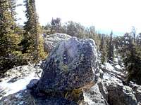 Topaz Mountain Summit
Due to seasonal closures of Forest Service Roads, Topaz Mountain is accessible from the north between early summer and late Fall, depending on snow pack. While Park County 77 is plowed, southern access will be hampered by heavy snows, lengthening your approach to this summit. The access roads in this area melt out earlier and get snowed-in later than many higher-altitude, heavier-snowpack climbing areas in Colorado. If you want solitude, visit this peak in snow season. Summer, in particular, brings heavy, heavy crowds to the Lost Park area. Campsites are at a premium in the warmer months, traffic is thick, motorized recreation is heavy and other visitors swarm the dirt roads. |
External Links
 On Topaz Mountain summit, North Tarryall in backdrop.
Photo by RyanS
 Topaz Mountain Register
Pike & San Isabel National Forests
Pike National Forest Recreation Map