-
 41994 Hits
-
 82.48% Score
-
 15 Votes
|
|
Mountain/Rock |
|---|---|
|
|
40.84683°N / 112.49897°W |
|
|
Tooele |
|
|
Hiking |
|
|
Spring |
|
|
6647 ft / 2026 m |
|
|
Overview
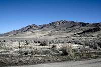
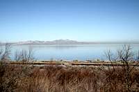
Named for Howard Stansbury after his 1850 survey of the area, Stansbury Island is the second largest island of the Great Salt Lake, afer Antelope Island. It's length is approximately 11.5 miles and is 4.5 miles at it's widest section. Stansbury is classified as an island, though it is connected to the mainland by a firm gravel road. The level of the Great Salt Lake continues to fluctuate, and can again rise enough to cover the road as it did in the late 1980s and early nineties.Stansbury Island has a 9-mile mountain biking trail that is popular among those that know about it. The trail follows part of the the island's "bathtub ring", the obvious ancient shoreline of the former Lake Bonneville. The highest point on the island is Castle Rock, at 6647 feet above sea level. (My GPS gave a reading of 6627 feet.)
If you know where to look, you can find petroglyphs made by the ancient inhabitants of the area, most likely forebears of the Goshute people. There are also at least two caves large enough to walk into. One is on the SE aprt of the island near the top of the wide cliff bands that face SE. Another is on the West side of the island at the base of a diagonal band of cliffs.
There are several geocaches on and around the island, and more information can be found at www.geocaching.com (do a search for "Castle Rock").
Stansbury is a desert island, but there is the usual wildlifelife. You might see lizards, wild turkey, jackrabbits, hawks, deer, and oh yes, the glorious grazing cattle.


There are about 5 high points on the island. Castle Rock is made up of three "turrets" that are close together and similar in altitude. The northernmost point of Castle Rock is the high point, but has the least in scenic value. The middle area is a giant's boulder pile with very fun cracks and passageways to explore The southern peak is connected to the middle point by a rocky saddle and a class 4 section of walls, ledges and slabs. Be careful here! There are plenty of places to hold onto, but there are just as many places to fall with serious consequences.
To the north of Castle Rock is another peak, and peak 5,927, is the high point on the island's southern end. From the SE approach from highway 80, peak 5,927 looks to have a flat top, but appears to be more slanted and steep from the western side of the island. The whole island can be traversed in a day starting from the bike trailhead or the campsite located off the side road a little further north.
Getting There
Red Tape