
-
 17021 Hits
-
 81.84% Score
-
 14 Votes
|
|
Mountain/Rock |
|---|---|
|
|
49.85330°N / 115.575°W |
|
|
Hiking |
|
|
Summer, Fall |
|
|
9177 ft / 2797 m |
|
|
Overview
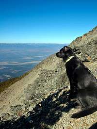
Teepee Mountain is located in the southeastern corner of British Columbia, near the historic site of Fort Steele and the present day communities of Cranbrook, Kimberley, Wasa, and Skookumchuck. It is part of the Hughes Range of the Rocky Mountain Chain and overlooks the Kootenay River Valley/Southern Rocky Mountain Trench which divides the Rockies from the Purcell Mountains. Teepee Mountain and Mount Stevens are the highest peaks overlooking Wasa Lake and lie about 10km (6 miles) directly west of Top of the World Provincial Park. They are also just west of the head of Diorite Creek.There are essentially three ways to approach Teepee Mountain. The first, and by far the most common, is the approach that starts near Lazy Lake and traverses over Mount Stevens. Once you have reached the summit of Mount Stevens, Teepee Mountain is approximately another kilometre (0.6 miles) to the north. Mount Stevens is a perfect place to stop and have lunch on one's way to Teepee. The second approach is from Fay's Lake to the southeast. Lastly, Teepee Mountain can be reached via the 29km (18 mile) ridge walk from Lakit Lookout to the south.
Mount Stevens and Teepee Mountain are often overlooked due to the popularity and visibility of Mount Fisher (better known as Fisher Peak by the locals) in the area. This is unfortunate, as this two summit day is certainly full of its own beauty and incredible views – especially into the endless sea of Rocky Mountain peaks to the east. For those wanting to summit Mount Fisher, Teepee Mountain (via Mount Stevens) can be an ideal warm up day for that next outing. The way up Stevens and Teepee is much easier (it is a hike the entire way) and in the end, Teepee mountain is only approximately 50m (165 feet) lower than Mount Fisher.
Although the hike up Mount Stevens and Teepee Mountain is certainly easier than the hike and scramble up Mount Fisher, it is still a fairly long and gruelling uphill slog to get there. The trail is in excellent condition, but does little in the way of switchbacks. For the most part, it relentlessly makes its way upwards through the forest of Douglas fir and the Canadian bunchberry found on this forest's floor. Make sure to take lots of water, as none will be found along the way.
Teepee Mountain was officially named so in 1959. There can be little doubt it received its name due to the conical shape of the mountain.

Getting There
Please note: I am only giving the driving directions to Teepee Mountain from the Mount Stevens Trail. These directions do not apply to the other approaches to the mountain.
From Highway 93/95, turn east onto the southern end of the Wasa Lake Park Drive loop. Drive 0.4km (0.25 miles) and turn right (southeast) onto Lazy Lake Road. From here, drive 10 km (6.2 miles) and turn right (east) onto Lewis Creek Road. If you see Lazy Lake, you have gone too far. From the turnoff onto Lewis Creek Road, follow the switchbacks upwards for about 5.2km (3.2 miles) until you get to a left turnoff signed "BR A". Park here - the trailhead is about 50m up this road and is marked clearly with a “Mt. Stevens Trail” sign.
Route Description
Map of Area

Red Tape
None.
When to Climb
The best season for climbing Teepee Mountain is late June through September.
Camping & Lodging
There are many options for places to stay in the area of Mount Stevens and Teepee Mountain. The closest are the campsites in Wasa Lake Provincial Park. Premier Lake Provincial Park is close by as well. Nearby towns include Cranbrook, Kimberley, and Marysville. All have several options for accomodations.
Wasa Lake Campsite Reservations
Premier Lake Campsite Reservations
Other local campgrounds
Fort Steel Resort and RV Park (Camping, cabins, B&B, RV camping)
Kimberley Riverside Campground
Sheep Heaven Farm B&B
Mountain Conditions
Be prepared for weather conditions which can change quickly in the mountains. Wind may also be considerable on the higher parts of the mountain.
Cranbrook Visitor Information: 250-489-5261
Kimberley Visitor Information: 250-427-4838
Environment Canada Weather Forecast

External Links
Geology of the Hughes Range
Columbia Valley Information
Wasa Lake Provincial Park