-
 6217 Hits
-
 85.75% Score
-
 21 Votes
|
|
Mountain/Rock |
|---|---|
|
|
44.84403°N / 6.52200°E |
|
|
Hautes Alpes |
|
|
Trad Climbing, Sport Climbing |
|
|
Spring, Summer, Fall |
|
|
8465 ft / 2580 m |
|
|
Overview
Tenailles de Montbrison 2580 m
The nice land of vineyards of Vallouise, lying in the Briançonnais area South to Briançon, is a valley rising from L’ Argentière la Bessèe towards NW. The upper sector of Vallouise leads to the summits belonging to the famous granite Massif of Ecrins, kingdom of high mountains covered by glaciers, while in the lower and Southern sector we can see the smaller but awesome limestone Massif of Montbrison, overlooking the orographical left side of the valley with different peaks: Tête d’Amont m. 2815, Pic de Montbrison m. 2818, Cime de la Condamine m. 2940, Rocher Boucharde m. 2900, the summit contiguous to the Ecrins, Tête d’Aval m. 2698 and Tenailles de Montbrison m. 2580. The Massif of Montbrison is well frequented in reason of the nice environment and the interesting trails, as the ascent to the Cime de la Condamine; anyway Montbrison reputation is above all due to the limestone quality and the extraordinary climbing routes “Dolomite’s style” running on the great S and SW faces of the Tête d’Aval and on the East and South faces of the Tenailles de Montbrison.


These summits are well-known also by the Italian climbers by means of their relative closeness to the Piedmont and the town of Turin. The Tenailles de Montbrison lie inside a superb “milieu”, as stunning dolomitic towers surrounded by meadows and larchs. The most impressive peak belonging to the Tenailles de Montbrison – literally “The Tongs of Montbrison, due to their peculiar shape – is the left tower, a stunning and slender twin-needle, which gives its name to the whole group: a veritable limestone pearl showing several high class magnificent routes on immaculate rock. Other summits of the little group are the Grand Doigt Central (Great Middle Finger) and the Doigt de Droite (Right Finger).
Getting There
Road access
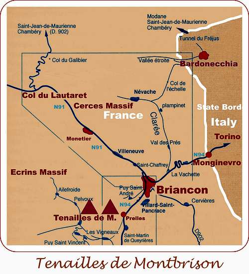
The starting point to get to the peak is the Forest Road of Bouchier m. 1472, an ancient village lying 17 km. South-West to the town of Briançon.
- From Turin (Italy)
Follow the A32-E70 Motorway entering Val di Susa and exit to Oulx, reach Cesana Torinese and Claviere, then Colle del Monginevro m. 1854, on Italy-France border; from here the road N94 descents to Briançon. From Briançon follow the road N94, turning left and reaching Prelles. In Prelles leave the main road, turning to right and following the “Route des Vigneaux” as far as 1 km. before Villard Meyer. Take on the right an unsurfaced road towards the little village of Bouchier and carry on towards North about 3 km. past Bouchier, getting to the Combe Brune. Stream, parking. 17 km. from Briançon.


- From Grenoble (France)
Follow the road N85 to Vizille, then the road N91 rising to Col du Lautaret; reach the Col du Lautaret m. 2057 and descent to Briançon. From Briançon follow the road N94, turning right and reaching Prelles. In Prelles leave the main road, turning to right and following the “Route des Vigneaux” as far as 1 km. before Villard Meyer. Take on the right an unsurfaced road towards the little village of Bouchier and carry on towards North about 3 km. past Bouchier, getting to la Combe Brune. Stream, Parking. 17 km. from Briançon.
Red Tape
No particulary restrictions in climbing and hiking.
Eperon Renaud classic route report


Eperon Renaud report – French scale
Summit altitude: m. 2580
Difficulty: TD, max F6b, F5c obbl.
Climbing length: 350 m.
Exposure: NE
Equipment: mainly bolts and some pegs, friends and nuts are useful to integrate
Approach difference in level: 450 m.
First ascent: Max Gerard – Raymond Renaud – Emile Rozan 1964 – Partially re-equipped by Gérard Fiaschi in 1988
Starting point: Combe Brune (Forest Road of Bouchier)
Most climbers prefer the other harder full equipped-style routes running on Tenailles, anyhow the Eperon Renaud is a great serious and spectacular route on beautiful limestone, the classic one of Tenailles, running on an obvious and aesthetic spur; the climbing style is modern, but the route is classic, above all due to the distance between the protections. The route, running on a very steep wall, is athletic and highly satisfactory. Climate sometimes may be fresh on the wall even in summer.
Approach: From the Combe Brune a trail - at first very steep - runs on the orographical left side of the stream, then gets a pleasant valley with meadows and larchs and leads to the bottom of the spur. Skirt the first slabs of the spur towards right, then scramble up some easy rocks towards left, heading to a big pine. Starting point of the route. About 1 and a half hour from the parking.
L1 – Climb up slanting left, then enter a long dihedral-crack. 4c, then 5c and 5b. L2 – Up a sloping slab, then a slanting corner and another slab to belay on a platform on the ridge. 3c, 5b, 4c. L3 – Climb the left side of the ridge, then a steep wall and a sloping slab on the left of the ridge. Belay on a ledge. 5b, then 4c L4 – A steep slab leads to a little terrace to the right of a pine. 5c, then 5b L5 – Climb a gully on the right of a spur, belay on a block. 4b


L6 – Climb a little steep wall on the right, then some steps to a belay on the right of a rocky mushroom on the summit of the first needle of the tongs. 5b, then 3b A 25 m. rap to the rocky saddle between the two needles, below the second needle. L7 – A great pitch. Climb a beautiful grey tower, at first slants to left, then directly on a sharpening edge. Belay on a rocky saddle. 4c. From here a retire is possible by four 45 m. long abseils along the SE face. L8 – Another great pitch, the crux. Climb a thin, hard and long crack slanting right, cutting a steep grey wall and ending below an easier crack. Climb directly the second crack to a belay inside a niche. 5b at the start, then 6b or 5c/A1, then 5b again. L9 – After a short and smooth dihedral-chimney, climb slanting right on some grassy steps, then head to left to climb a wall to a belay on a little terrace at the feet of another dihedral-chimney. 5c, then 4b, few equipped. L10 – Climb the dihedral about 15 m., then exit left on a slab leading to a belay on an airy narrow ledge.5c, then 5b. L11 – Climb a slab starting steep, then more sloping. Belay on the right of the edge of the summit crest. 5b+, then 4b L12 – Climb the summit crest to the top of the second needle. 3b, not equipped.
Descent: from the summit keep on along the summit crest, downclimbing for about 15 m. to an anchor. Do a 30 meters rap, then traverse right by walking (to NW) along some ledges nearby a pinnacle, cairns. Downclimb towards right – a short easy but “expo” traverse – getting to a trail slanting left and crossing the scree, leading to the bottom of the spur. 1 hour from the summit
Other routes

- Vol et volupté TD+, F6b+ or 6a and A0, 350 m., 12 pitches. Various modern route equipped with bolts and some pegs.
- Infinie patience TD+, F6c, or 6b/A0 - 300 m. Modern route, bolts. Gerard Fiaschi- Rambaud –Jean Michel Cambon
- Péril en la Demeure ED-, 7° or 6b/A0 – 300 m., 12 pitches Modern route, bolts
- La fiesta del sud TD, 6a+, 6a obbl., 250 m., 9 pitches
- Via Ioan TD-, 6a, 5b obbl., 220 m.
On the Grand Doigt Central
- L'écume des jours TD+, F6c, F6a obbl., 400 m., 13 pitches
On the Doigt de Droite
- En avant la zizique TD-, 6a+, 5c obbl., 350 m.
Where to stay

- Gite d'etape in the little village of Bouchier
Several possibilities of accomodation in all the Briançonnais area (Gites, Hotels, Equipped camp-sites)
When to climb
Best season goes from the middle of May to the middle of October
Meteo
Guidebooks


“Oisans Noveau, Oisans Sauvage - Livre Est” by Jean Michel Cambon - Vertical ED.
"Alpes du Sud and Provence - Escalade Plaisir" by Hervé Galley - Edition Olizane
Maps
IGN 3436ET Meije - Pelvoux Parc National des Écrins