
-
 12488 Hits
-
 77.48% Score
-
 8 Votes
|
|
Mountain/Rock |
|---|---|
|
|
44.47887°N / 114.80164°W |
|
|
Custer |
|
|
Summer, Fall |
|
|
10341 ft / 3152 m |
|
|
Overview
The General is a very remote peak about twenty miles north of Stanley, ID. At 10,341 feet, it is one of the tallest mountains in the Salmon River Mountain Range, and definitely the tallest mountain in the area. It's remote location creates an extremely secluded atmosphere around the mountain. As of July 25th, 2009, only three signatures were recorded in the log book (the first signature dating to 1994.) The mountain itself is made up of very fragile shale rock, making climbing the steep face nearly impossible.The view from the top of the General is absolutely phenomenal. On a clear day it is easy to make out the far away Lost River Range and the jagged Sawtooth Range
Getting There
There are no roads that come close to this mountain. However, there is one good point at which you can begin a multiple day excursion towards the General.Begin by heading north out of Stanley on ID-75. After 13 miles turn left on Yankee Fork Rd. Travel down the dirt road for roughly another 8 miles before turning left on Loon Creek Road at the Jordan Creek drainage. Drive up Loon Creek Road for some time, eventually making your way up some extremely steep switchbacks(4wd recommended.) At the top of the switchbacks you will find a sign marking the Loon Creek Pass. This is where you want to begin on foot, hiking northwest towards the mountain.
From this point, a good topo and a compass should be able to get you to the mountain. It is a good two-day hike to it. Be warned though, there are many cliffs of well over 200 feet that will sneak up on you. Always take your time and plan your routes with a topographical map.
If you are a nature lover, stay quite. This area is heavily populated with elk, bighorn sheep and mule deer. If you get lucky you can even spot rocky mountain goats, bald eagles, and the ultra rare wolverine.
Campsites Around the Mountain
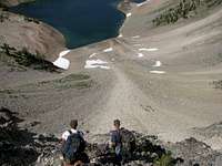
"Jordan Lake"There is an unnamed lake at the foot of Mount Jordan, just southeast of the General. This lake is hard to get to without some cliff descents, but it's perfectly clear blue water is well worth it, and it offers a great angle for starting the General.
Mystery Lake
There is a lake that sits in a bowl just east of the General. The problem with this lake is that it is completely inaccessible without some steep rock climbing descents of over 200 feet. The bowl that it sits in has extremely steep and rugged edges to it. However, if you brave the down-climbing, the camping by the lake's outlet is superb.
 The only way into Mystery Lake
Supplies
Aside from your typical backpacking supplies it is recommended that you take at least one climbing rope to aid with the mandatory class 4 scrambling. Also, during the late summer the mosquitoes around these lakes are hungry. Definitely bring some powerful bug spray.
Routes
Coming towards this mountain from Loon Creek Pass means that you only have two options for summiting. There is the South Ridge and the Southeast Ridge. Both ridges are made up of talus rock, and require much endurance to climb.Seasons
The only time of year that this mountain is accessible is from the middle of summer until the middle of fall. The snow is not plowed on any of the access roads during the winter, and takes until at least mid-June to melt off.Red Tape
Like most of Idaho's back-country, there is no red tape.Weather

drewbtlr - Feb 7, 2013 7:01 pm - Voted 10/10
getting there, another routeThere is actually a trail head for Mystery Lake if you continue down into the valley from Loon Creek Summit. Continue along the road, it gets very rough but is passable make sure you have a high clearance vehicle and 4 wheel drive, this road is notorious for flat tires and busted oil pans. After descending into the valley continue along the road, it's a little bit of a drive but on the left hand side of the road you will see Mystery Creek coming out of the woods. There is a parking/camping area off to the side. The trail heads up following the creek most of the way, there is a great waterfall overlook about half way up but be careful if you decide to venture out for a better view because it is covered in loose rock and is a long drop down. The trail can be hard to follow at times and is very steep in sections (hand over foot). About two miles up the trail you crest a ridge and come down into the lower lake, great camping and fishing here. The woods around the lower lake are dense enough to provide shelter from the elements. Looking South West across the lake (facing The General) you can make your way around the left (East) side fairly easily where you'll find Mystery Creek, you can follow the creek to the upper lake. There is a "trail" it is a very steep and tough way up but it is very worth while. Once you crest this ridge, the view of Upper Mystery Lake with The General looming the the background is spectacular. From here you can make your way around the right (West) side of the lake to a ridge leading to The General's summit. I personally have only made it half way up this ridge before having to turn back as night fell, but from where I got to, it seemed like a very viable route to the top. Going this way, I would suggest making it a three day trip. The hike up from the parking area to the upper lake is a tough one, about three hours of brutal uphill gaining about 700 vertical meters and roughly 3.6 km long (based on Google Earth). Either lake makes for great camping and if you're a fisherman, bring along a float tube because there is some great fishing at both lakes. All in all, this is a very remote and beautiful area to explore. Parking lot lat/long: 44 30,08N 114 46,33W
climbinmandan - Mar 11, 2013 4:55 pm - Hasn't voted
Re: getting there, another routeYes sir, I know the spot. I drive past that on the way up elk hunting every fall. Thank you. Daniel
mtybumpo - Jul 7, 2013 11:58 pm - Hasn't voted
ElevationFYI the elevation of The General is 10,329 ft. and not 10,341 ft. as posted here. This is what is marked on the USGS topo and other sources I have encountered.