
-
 36590 Hits
-
 88.61% Score
-
 27 Votes
|
|
Mountain/Rock |
|---|---|
|
|
48.68826°N / 121.32269°W |
|
|
Whatcom |
|
|
Hiking, Scrambling |
|
|
Summer, Fall |
|
|
5966 ft / 1818 m |
|
|
Overview
 The Southern Pickets Seen from The Summit
Trappers Peak is what some hikers might call low-hanging-fruit, with it's relatively easy access and spectacular views of the North Cascades. It makes an excellent choice for a day trip but it can also be combined with a night at Thornton Lakes or other peaks such as nearby X Mountain, Thornton Peak, or Mount Triumph.
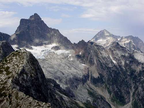 Triumph and Despair Seen From The Summit
There are several amazing sights that draw people to this particular summit. The impressive east face of of Mount Triumph rises 500 vertical feet above a broken-up, receding glacier. Another sight worth seeing is the jaw-dropping view of the southern Pickets Range, located just 5 miles to the north. As you may know, getting a good view of the Pickets is somewhat of a rarity. That is part of what makes Trappers Peak special. Furthermore, it has been said that Trappers is a personal favorite of local peakbagging legend John Roper. This is the peak that started his obsession/passion. So watch out! It could happen to you too.
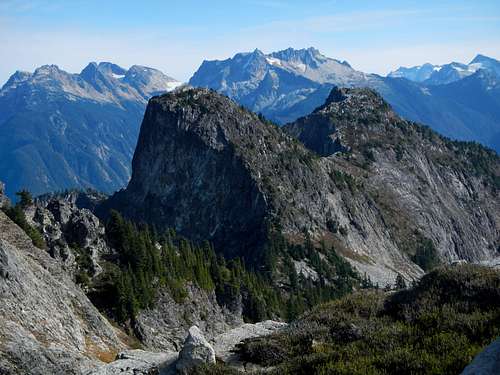 X Mountain and Trappers Peak seen from Thornton Peak
The standard route makes use of the Thornton Lakes trail and then branches off to follow the south ridge of the peak. There is some mild exposure but only a few class 3 moves are required to reach the summit. Bears and berries are commonly encountered in the summer months. Only experienced climbers should attempt a winter ascent.
![Thornton Lakes, Mount Triumph and Trappers Peak]() Thornton Peak and Thornton Lakes
Thornton Peak and Thornton Lakes
![Exposed Ridge]() The Narrow Section Of The Ssouth Ridge
The Narrow Section Of The Ssouth Ridge
The trail down to the lake is a knee bashing descent of just over half a mile down to the only real obstacle you'll meet on the whole trail. There are some huge, down-sloping boulders and a log jam to negotiate before you can finally drop your pack at camp, 5.2 miles from the trailhead.
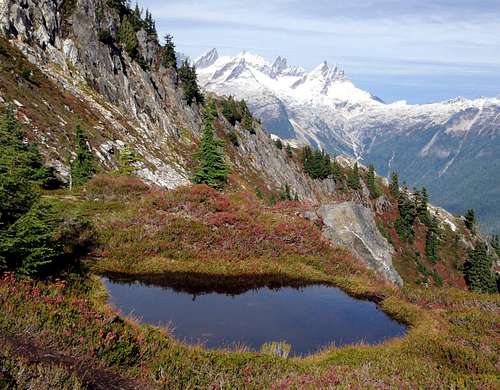
![Trappers Tarn]() A Tarn On The South Ridge
A Tarn On The South Ridge
The boot path to Trappers Peak ascends about 1000 feet along a beautiful ridge/blueberry buffet that offers beautiful views of the lakes, Triumph, Despair, Forbidden, Torment, the Pickets and everything in between. a few easy class 3 moves along a semi-knife-edge keep things interesting and before you know it, you're on top. For those who plan to continue on to X Mountain, keep in mind it's not as bad as it looks.
![Vertical Drop]() The Precipitous North Face
The Precipitous North Face
![Mt. Triumph in winter. Photo...]() Triumph Seen From The Summit In Winter
Triumph Seen From The Summit In Winter
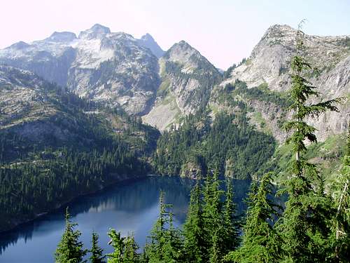 Thornton Peak and Thornton Lakes
Standard Route - South Ridge
The trail starts off with a very gentle grade with a couple of creek crossings as you make your way through forest for 2.3 miles. Ascend steadily climbing switchbacks for the next couple of miles. The trail then begins to mellow out a bit as you traverse some alpine meadows chock full of blueberry bushes. Near the ridge top, watch for a boot path branching off to the right to Trappers Peak. The main trail goes left down to the campsites at the lake.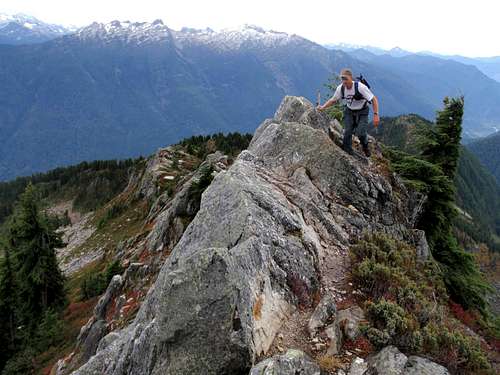 The Narrow Section Of The Ssouth Ridge
The trail down to the lake is a knee bashing descent of just over half a mile down to the only real obstacle you'll meet on the whole trail. There are some huge, down-sloping boulders and a log jam to negotiate before you can finally drop your pack at camp, 5.2 miles from the trailhead.
 A Tarn On The South Ridge
The boot path to Trappers Peak ascends about 1000 feet along a beautiful ridge/blueberry buffet that offers beautiful views of the lakes, Triumph, Despair, Forbidden, Torment, the Pickets and everything in between. a few easy class 3 moves along a semi-knife-edge keep things interesting and before you know it, you're on top. For those who plan to continue on to X Mountain, keep in mind it's not as bad as it looks.
Driving Directions
Coming from the western Washington, take hwy 20 east to Marblemount and proceed and 11 miles towards Newhalem. Turn left on to Thornton Lakes Road and drive 5 miles to the end of the road where the trailhead is located. The road is a bit rough but passable with a 2wd if you drive carefully.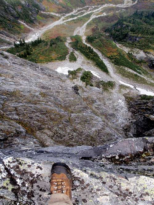 The Precipitous North Face
Red Tape / Camping
Pick up a permit at the Marblemount Ranger Station if you plan to stay overnight. They also have a voluntary climber's registry. There are only 3 camp sites at Thornton Lakes so arrive early if you want a permit on the weekend. The campsite at lower Thornton Lake has a composting toilet. Be sure to hang your food.External Links
North Cascades National Parks Service - Thornton Lakes Trail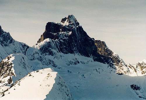 Triumph Seen From The Summit In Winter
- June 2006 trip report by dicey
- June 2007 trip report by Payton
- September 2008 trip report by furthur
- June 2009 trip report by raising3hikers
- September 2009 trip report by Bloated Chipmunk
- October 2010 trip report by iron
- October 2010 trip report by Bryan
- October 2010 trip report by bonobo
- September 2011 trip report by Aubrey
- August 2012 trip report by Joe
awilsondc - Sep 5, 2016 6:01 pm - Voted 10/10
LinksThe links to the r3h and BC trip reports both link to the r3h report. Here is the BC report link. Also the iron and Bryan reports both link to Bryan's. Here is the link to iron's report. Also since you've been up there a couple times what do you think of the feasibility of a X Mountain to Thornton traverse? Looks like it could be sketchy, but hard to tell from the photos I've seen and I can't find any beta about it. Just curious... Thinking about getting up that way soon.