The idea
Since I live in Poland, I haven't changed my habits, and I spend my time planning and dreaming future trips in the mountains of my country of adoption. Let's say not exactly, Polish and Slovak mountains, since they form together the northern Carpathians. And the most famous mountains of the area, everyone knows, are the
Tatras.
A lot of people in Poland love the Tatras, and I don't fail to the rule. This is indeed the first place I ever visited in Central Europe (2004), before anything else, even Cracow. This was a one-week traverse, which left me the slightly frustrating feeling not to be able to visit all corners of this magnificent range as it deserved.
But here we are, now I live in Poland and I have all time I want to fulfill my crazy desires. I usually plan some 2-3 days hikes, the time of a long week-end, often with my wife, sometimes alone, sometimes with other friends, to visit specific areas.
This time, it was the best moment of the autumn, the penultimate week-end of September. There was a splendid and unmistakable anticyclone settling down for few days. But for some work reasons, I couldn't afford taking one day off, it had to be Saturday and Sunday. Furthermore, Dorota was busy with some homework, some snow had fallen, and she was not too keen in such sporty trip.
![My friend Romain during the climb to Baranie Sedlo]() Romain
Romain
But, since few months, I have Romain: a new French mate as passionate as me by mountains, who lives some 200m far from us, what a coincidence! We use to say that there is nothing than a good mountaineering trip to build a genuine friendship with someone. This trip was simply fabulous, and since then, Romain is the best friend I have in
Wrocław.
I had an idea in my mind since some time. During the first trek of 2004, first, I "forgot" to climb the splendid peak
Jahňací štít, when I was at the refuge
Chata pri Zelenom Pleso. I also wondered at this time whether or not it was possible to cross the pass via Baranie Sedlo, to reach
Téryho Chata, but I quickly understood that according to the offtrails regulations I couldn't (eventually, I circumvented the massive via Skalnaté Pleso).
This year (2007), I was member of the WKW, as I started learning rock-climbing, so I had a license. Romain not, but he had an Austrian one from a trip in the Alps the same year (UIAA card holders can go offtrails in certain conditions (not always very clear)). The idea came as I read about
projects of reopening historical trails, closed nowadays, such as Baranie Sedlo.
I asked him if he was keen in taking the potential risk to be controlled and fined, against a nice peak of more than 2500m, and he replied immediately yes ! The goals for these 2 days were found.
![Vel ka Zmrzla Valley (january...]() Dynercia's route
Dynercia's route
The plannification of this excursion was my first encounter with SummitPost, when I found the nicely described
routes by
Dynercia, which I printed at work on Friday.
Leaving Wrocław
At 4pm, I jumped on my bike from work, I was at home half an hour later, and at 5pm, Romain came on foot from his flat, rucksack and ice-axe on it, dry clothes and food in the hand.
We had chatted by Skype during the day (as we always do at work). "Should I take the crampons ?", he asked me. "Better having them than not, just in case", I replied. It doesn't take so much place in the boot after all.
![Schronisko <a href= http://www.pza.org.pl/szkolenie/index.acs?id=308004 >Betlejemka</a> in Dolina Gąsienicowa (Polish Tatras) , by night.]() Nocturn arrival
Nocturn arrival
Few minutes later, we were speeding on the A4 motorway. We passed Katowice, but a bad surprise waited for us: the portion before Krakow was under maintenance, and we found a big traffic jam. We finally reached the exit at Krakow and took the "Zakopianka", the road heading south to the mountains. Here also, a lot of traffic, the whole Poland had watched the weather forecast ! It was getting late...
After searching in vain for a while in the darkness of the village we were staying for the night, we finally called the phone of this house in Jurgów. The owners were still waiting for us, and we ate our dinner at 11pm. Despite the very short night we had in this place, I definitely recommend this friendly and good-looking
guesthouse.
Jahňací štít
![The White Tatras from the road between Jurgów and Podspady]() The Jurgów road
The Jurgów road
As real mountaineers, we had planned an early morning, considering the fact that we were still not exactly at our starting point,
Ždiar . As I expected, just before passing the border, this road, which is also an excellent alternative to avoid the crowded resort of Zakopane, provided us stunning views to the sub-range of the
White Tatras.
Including the time we spent removing the frost on the windows, we reached
Ždiar one hour later, but it was still early (7am). We parked the car on a large parking space near the church at the centre, prepared bags and equipment, and dressed.
We started walking in the direction of the valley Dolina Monkova, passed the superb clearing where is the villa "
Pension Liptak", and soon reached the toll of the National Park. This is the only trail in the whole Slovak Tatras where there is such toll, since this trail was reopened recently after many years, following costy maintenance to prevent from ground-slipping. Our hopes to find no one in the cabin before 8am vanished, but fortunately the cost is not really expensive (not like
some valleys of the Polish Tatras...)
![Pension Liptak , near Ždiar, on the foot of the <a href= http://www.summitpost.org/area/range/324758/belianske-tatry.html >White Tatras</a>]() Pension Liptak
Pension Liptak![Monkova Dolina & Spišská Magurka]() Monkova Dolina
Monkova Dolina![Chamois of the Tatras]() Chamois
Chamois
Then we started the long climb through the forest of Monkova Dolina. I walked this place once before, in 2005, but in the fog. Now, we had a brilliant autumn light, with superb views to
Spišská Magura,
Gorce, and the rest of the Podhale county in the far distance. Later, we reached the pastures, as well as the first slices of snow, remains of early falls at the beginning of September this year.
Just before reaching Široké Sedlo, the main pass in the
White Tatras, we noticed a group of people stopped in the middle of the trail, looking aside. There was a herd of something. First I thought about deers, but with their white tail, I realized there were chamois. Never in my life, except perhaps once in the Pyrenees but from much further, I had seen so many. Same for my friend Romain. We counted them, they were exactly 48, grazing lazily on this mountain side warmed by the morning sunlight, not bothered at all by the presence of a little crowd!
We kept walking and met four more, even closer, few hundred of meters ahead. Then, at Široké Sedlo, as we opened the bags for a short refreshing break, four again. We took fine photos with the zoom.
![56 chamois of the Tatras all together !]() The group of chamois
The group of chamois
As we reached this point, and as I expected, the panorama of the highest peaks of the High Tatras suddenly revealed itself to our eyes. There is no other place I know in the Tatras, which provides such a breath-taking apparition. A bunch of the most jagged and formidable granitic peaks of the Tatras stand like an inaccessible fortress. Romain was also out of breath. The snow that had fallen recently enhanced the darkness of the granite they are made of, they looked like some cake sprewn with ice-sugar, indeed, more scary than ever. In them, there were
Jahňací štít,
Baranie Rohy, our two goals...
![The (very) High Tatras, from Široké Sedlo]() Panorama from Široké Sedlo
Panorama from Široké Sedlo
"You were right on Skype, told Romain; I think we do need the crampons".
"Shit, I said to myself, perhaps we should have chosen the
Western Tatras instead..." (more gentle side of the range...)
"Let's see !" We finally decided to continue. After all, the hike to the lake Zelené Pleso is always possible, and for sure a pleasant hike. As for
Jahňací štít, we'll go as far as the wisdom tells us, and for the Sunday, we'll advise what to do when we will be at the hut.
We started the descent and then the short bumps leading to two other little passes, Kopské Sedlo and Predné Sedlo. The section of trail that follows is one of the finest of the Tatras. The trail goes through a large trench where dwarf pine are cut off (the dwarf pine of the Tatras, "Kosodrzewina", is so dense that normally one cannot make his way through). Here and there are some mountain rowans whose leaves the autumn
turned perfectly red, as well as dozens of different kinds of conifers. This is not without reasons that this area, "Dolina Sedmich Prameňov", is called "Tatra's" botanic gardens.
![The White Tatras, from Trojrohé pleso]() Bielé Pleso
Bielé Pleso![Dolina Zeleneho Plesa, in Autumn]() Dolina Zeleneho Plesa
Dolina Zeleneho Plesa
The trail goes along a group of 3 little lakes, "Bielé Pleso". These lakes are not glaciar lakes like most of the Tatras lakes, but resulting from a ground depression, and surrounded by peat. This is a rare ecosystem.
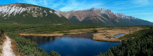
Later, the same trail takes us slowly into the entrance of the "Dolina Zeleneho Plesa", the "Valley of the Green Lake", as the lake located in its end is. Slowly, the trail slowly unveils the wild majesty of this deep valley, surrounded by some of the highest peaks (on the South,
Lomnica, Tatra's 2nd in height).
![Dolina Zeleneho Plesa, in Autumn]() Zelené Pleso, the "Green Lake"
Zelené Pleso, the "Green Lake"
We reached the
refuge on the shore of the lake, nestled in the final amphitheatre, in the beginning of the afternoon, and had our lunch on the terrace overlooking the lake. We spent this time wondering if, at this season, there was any moment of the day when the rays of sun reach the lake; the answer came around 2pm when a splendid light reached the shore, enhancing the beautiful emerald colour of the water. The other topic we discussed was how the way to the pass Baranie Sedlo, now visible, looked. As expected, it was in the snow, but we could clearly see footprints in the distance.
Anyway, this was not the goal of the rest of this day, and we quickly went to ask the hut-keepers for leaving one bag at the storage local. As most of the huts in the Tatras, such facility is available for long distance hiker who do not want to carry unnecessary items the time of way-and-back excursion. This is the case for our
Jahňací štít so we leave all duvets and stuff into my bag, while both pairs of crampons, water, ice-axes and walking sticks go to the bag of Romain. We will carry it half and half.
![The glaciar valley leading to Jahňací Štít]() Červená Dolina
Červená Dolina![The last meters to Jahňací Štít]() Romain on the ridge
Romain on the ridge
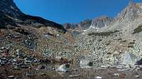
We started to climb the trail to Červená Dolina, first steep into rugged vegetation, then into a large desertic rocky valley, whose ending edge is the ridge to the peak. After walking the final parts on the snow (which was, by the way, the very first time of my life I touched snow in September), we reached the pass Kolový Priechod.
From this point, the summit is just few hundreds of meters further. On the contrary of our first feeling of the morning, as we saw the range from Široké Sedlo, we were reassured to see that almost no snow was remaining on the ridge, since it is exposed south and receives all the sunlight. There was only the very last part, with a tricky icy section, which finally convinced us that the crampons were not taken for nothing, and few seconds later we were enjoying the panorama at 2230m.
![From the summit, looking to the whole White Tatras.]() Jahňací štít panorama to the White Tatras
Jahňací štít panorama to the White Tatras is a fabulous promontory to watch the panorama to the
White Tatras. The views in the other directions, most of them to the other peaks of the High Tatras, are stunning. The only deception comes from the fact we cannot recognize
Baranie Rohy from here; it is hidden by Kolový štít.
In this region of Europe, and at this time of the year, the sun is already going down quickly, so we didn't spending hours on the top of
Jahňací štít, despite the brilliant and cool weather, which could almost allow us to stay dressed in a t-shirt.
During the descent, as we crossed again the rugged vegetation level, we could observe and discuss the way going down from Baranie Sedlo to the lake. As we stopped, we noticed three red spots, and we will observe their progression while walking, as they made perfect examples for the day of tomorrow. The tricky section is a sort of steep rocky level of some hundred meters of height, in the middle of which seems to be only one convenient way.
Dynercia described it accurately in the printed page and we could recognize it clearly.
![Climbing down Jahňací Štít, looking to Zelene Pleso]() The way down to the hut
The way down to the hut
We arrived at the refuge in the same time as the three red spots, which turn to be three fit mountaineers. I observed carefully their jackets, trying to notice some symbol on it and find out if they were some kind of guides, but they were not. This encouraged us even more for the next day and we decided to make it as we planned. After all, if it turned to be too dangerous, we could always return when we wanted, and today was surely a first success.
![Chata pri Zelenom Pleso]() Chata Pri Zelenom Pleso
Chata Pri Zelenom Pleso was packed with people. As I always do, we didn't take the effort to try to book it, which is in general pointless before a nice week-end, especially such short delay before (which is unfortunately the rule in all popular mountains: people book quicker than good weather forecast tends to show up).
We ate in the canteen sitting very tightly amongst other people. My left neighbour turned to be a lone Slovak hiker who spoke a very good English, so Romain and me started an interesting discussion with him. Not long after, as people went and left more space, we opened the map, as well as three beers, and discovered his immense knowledge of the Tatras. Then we feared that he would be himself some guide or ranger, so we avoided telling him our plans, but speaking geography of the sector, I asked him vaguely how does Baranie Sedlo looks like. "Yes yes, of course, it's ok !".
The night to come was going to be tricky. There was not enough space in the refuge but the hut-keepers had planned it, and there was a military tent pitched behind, so the extra people without reservations could also sleep. With the storage local in addition, everyone could fit, and Romain and me were amongst them.
We were amazed of the infinite patience and politeness these Slovak hut-keepers showed (Polish hut-keepers in
certain places should take example !), despite being clearly over flooded by the amount of people with various requests : "Extra mattresses here ? Covers here ?", as well as asking for paying the night and possible discounts as they were moved to the tent. As for us, it turned out that the Austrian license of Romain, for some obscure reason, gave more discount than my PZA one ! But the difference was insignificant.
After SMSes sent to our respective worried wives, the molecules of beer started to work on our brains, and, combined with the air of high altitude, we quickly felt asleep despite many kinds of snorings in every corner.
Baranie Rohy
![Zelene Pleso at sunrise]() Sunrise
Sunrise
The morning came quickly, no need to have an alarm clock, noises of all sorts prevented us to sleep for real, and at 6am we both felt breathing the fresh air rather than spend a supposedly lazy morning in this packed place.
The gas cooker was amongst our items, partly because our plan was to leave the hut before the official breakfast was served, reduce the chances to be seen as much as possible and avoid possible troubles.
Partly also, because the same day we were to drive back to
Wrocław...
The teas and slices of bread with jam were quickly eaten, and we left just in the moment the staff opened the breakfast room.
One all items were packed again, we started to walk; we crossed the bridge and immediately after, followed the shore of the bridge, staring walking offtrails. In the dense vegetation of dwarf trees that follow the lake, we quickly became invisible.
![Lomnica as seen during the ascent to Baranie Sedlo]() Lomnica
Lomnica
The rocky level we had observed the way before arrived, and thanks to the printed SP description, we quickly identified the rocky bar right from the waterfall, and noticed there were fixed chains on it. Thanks to them we finished quickly with this obstacle and soon reached a level of wild rocky boulders, marked with cairns. The first rays of light came, illuminating with golden rays this landscape. The hut was out of sight for a while and we made the first drinking pause.
Lomnica, Tatra's 2nd peak in height, topped by the observatory building, seemed to be more than ever within reach of hand, via a friendly inclined slope. In this very moments, for some reason, I pictured myself the saddle of Baranie Sedlo somewhere more on the south, in the very end of this glaciar valley. But, reading the text again and watching the map, it quickly came to evidence that it was a large gap that we could see from the hut itself. From downside, it didn't look like a too friendly pass, but from here it looked different. What's more, we noticed fresh footprints leading to it... someone who went before us this morning! Who could it be?
![Nearer and nearer to Baranie Sedlo... Steeper and steeper too]() Baranie Sedlo
Baranie Sedlo
As we started walking again, soon we had to stop as we walked on the snow, and realized it was pointless to wait to put crampons in the last moment. Then, we walked again, and the slope got steeper and steeper... Soon we met the footprints we observed earlier, and followed this comfortable trace. We had to pay extra attention near the end, as this autumnal snow was not very consistent, and carefully stabbed the snow as deep as possible on every step. Then, we reached the rim of the pass.
![At the ridge of Baranie Sedlo]() On Baranie Sedlo
On Baranie Sedlo
"Hello ! So here you are !". Before we had started to examine the landscape on the other side, we turned suddenly our heads, and discovered that our neighbour from yesterday's dinner was in fact already going down from the summit of
Baranie Rohy ! "You went there ?", we naively asked. "Yes, yes, it's ok ! Pay attention at the very beginning but the rest is a piece of cake". We were indeed relieved to see that he was not a guide or ranger as we suspected the evening before !
In the same moment, appeared a couple of Czech climbers from the other side of the pass, to with we started to chat too. They also listened to the advice of our lone predecessor, and spontaneously, we decided to continue to the top the four of us together, after a little break.
![On the ridge from Baranie Sedlo to the top Baranie Rohy]() On the ridge
On the ridge
Malá Studená Dolina, the valley of the other side, unveiled its splendid panorama, bathed in the sun. The upper lakes were frozen and masked in a cap of snow, while the lower ones shined in the light. Just in front of us, the impressive peak of
Ľadový štít; a bit further behind,
Gerlach, both looking like in the middle of a deep winter. From the side we came from, we could notice the lake Zelené Pleso, visible again, and, also bathed in the light, showing an incredible emerald tone right in the middle of the reddish cover of the Autumn.
The difference of temperature on the ridge was really amazing; the only reason we didn't freeze on the way up in the snow was that we were climbing up. But now, we could suddenly afford staying in T-shirt, without a single piece of wind. We were simply blessed by the weather...
![The wide plateau on the top of Baranie Rohy]() On the top
On the top
We started to walk in the direction of the summit, and had to pass carefully few easy but exposed scrambles. Then, the slope on the western side of the ridge went more and more gentle, and finally, as we reached the top, this mountain looked like a large football field covered with snow, with a only slight inclination to the south. We found some people on the top, for many of them, obviously not in more regular situation than us, not to say looking less professional, with less equipment.
During all the time we spent on the top, one Pole sitting next to us was struggling to boil a tea with his gas, while the wind was constantly pushing the flame aside. As we walked down we even met another couple of Polish without even using crampons ! This was, in my opinion, pure unconsciousness, considering the nature of the snow, especially on the side they came from, bathed in the sun and melting quickly...
![Western panorama to Ľadový štít, from Baranie Rohy]() West panorama from the top
West panorama from the top![My friend Romain in the descent from Baranie Sedlo]() The descent
The descent
This is the reason why, after few shots and 2 cups of tea, we decided to get off and start the the way back "to
Wrocław".
Fortunately, the slope in the valley Malá Studená Dolina was steep only for a very short while; few meters later, we could afford saving some time slipping on our back on the snow, until we reached the first rocks. We were attentively observing who else was climbing in our direction (we had met a couple of other people going to Baranie Sedlo), because the next ones could still be rangers, until the last moment. But, instead of rangers, we only met few marmots, hiding here and there amongst the rocks.
![The lakes in the valley Malá Studená Dolina]() valley Malá Studená Dolina
valley Malá Studená Dolina
Then, we found again the marked trail and went off the "illegality".
We took some pictures of the lakes of this valley and went for a beer in
Téryho Chata where, despite of my efforts to speak my best Slovak, the hut-keeper congratulated me for ... speaking so well Polish !
![Teryho Chata in Malá Studená Dolina]() Téryho Chata
Téryho Chata
Reaching this hut provided me a sort of hardly descriptible satisfaction , which I could call perhaps in the best way a "geographical satisfaction". Through this high saddle, we had made the junction between two places which reminded, in my mind at least, and at the scale of time, much more distant, not to say completely different. This is the kind of experience which provides suddenly the feeling to know a mountainous region like a "surface", more than just a "linear" knowledge, as the High Tatras had always been in my mind until now.
As for my friend Romain, he was highly satisfied with this semi-winter experience of the Tatras, this nice weather, the astonishingly beautiful places we kept crossing since Saturday, the part of adventure and suspense this trip reserved us, and finally this unexpected success, the snow making it even better.
![The lower part of Malá Studená Dolina]() Malá Studená Dolina
Malá Studená Dolina
Anyway, we hadn't finished to cross nice places. The lower part of the Malá Studená Dolina, brightened by the sun, also showed its lot of beauty, until we slowly reached the forest level. Here again, colourful trees, fine pine vegetation, fairy like smells of conifers.
We reached
Zamkovského Chata where we ate. After filling the bottles (the last sip of water was finished), we had a look at the
timetable of the busses I also had printed from Friday.
![View to Malá & Veľká Studená Dolina]() Panorama near Zamkovského Chata
Panorama near Zamkovského Chata
The bus which was to take us back to
Ždiar and our car was leaving at 5:30pm from Tatranská Lesná, and it was 4pm. We were not exactly late, but we had not realized it until now: there was no more time to loose !
![The lower part of Malá Studená Dolina]() Trail
Trail
Immediately, we started walking at a quick pace, going fast and making our way in the middle of the afternoon crown which grewn as the road was getting closer and closer. We were not exactly running, but not far !
We reached the end of the conifers and walked the last kilometres in the ravaged part of the forest (a very strong storm in the winter 2004 swept all trees on the southern piedmont of the Tatras). Then we found the road, and the bus stop.
The return
![Winter panorama to the High Tatras from the car park of Biela Voda]() Panorama to the Tatras from the road
Panorama to the Tatras from the road
"Oof", we made it with ten minutes of advance ! Said Romain, a bit exhausted, just like me. We immediately checked that the timetable displayed on the sign was the same as on the paper (with Slovak busses, you never know), but it turned to match. We had time, so we threwn neglectively the rucksacks, and removed messily one or two things from inside, in order to reach some sandwiches or cookies. I thought this vision of us waiting on an empty road, for an autobus whose punctuality was with hypothetic, was kind of fun, and I had the camera under my neck, ready to take the picture of Romain and sandwiches. But Romain didn't look at me.
"Eric, quick ! Let's pack ! A bus is coming and I can already read Ždiar on it !!"
I didn't take the picture, we put back summarily all things in the bag, then I removed everything again to reach the money, then everything in again. The driver waited. "Kde !?", he asked ("where ?").
Ždiar, we answered together, while stepping in.
"But wait ! No, not this bus !" he shouted, while all passengers were starring at us. "Okolo ! Okolo !", he kept repeating (which means "around"). We did not understand, but I finally asked "is this bus going to
Ždiar or not, yes or no ?". "Yes", he replied. " But around !".
![Ždiar]() Villages near the Tatras
Villages near the Tatras
As we were sitting, an old woman explained us the situation: this bus did go to
Ždiar, but not by the shortest way. It was first going to Kežmarok, Spišská Belá, then Liptak, and so on, which meant a diversion of at least 40-45mn. That's why we should have waited for the next one...
"Relax, Eric, it's not a problem !", repeated Romain, always positive. "As long as I see new places, it's fine for me !".
We crossed a half dozen of small villages. Old people, teenagers, farmers, children, all kind of people from the region was going in and out, it was fun to watch, Romain was true. The Tatras were visible far in the distance in the evening light. There is no other angle from the Slovak plain from where they look so much like an anomaly of the geology, with their surprising striking shape. "What a strange range", we thought, remembering our two days inside "this".
As the bus got nearer again from
Ždiar, we crossed few abandoned settlements inhabited by gypsies.
Out of any "ethnic" considerations and "politically correct", the vitality and the amount of activity of these people always amazed me. In such places where there is nothing else to do than waiting for an improbable future, they are always doing something: moving the bodywork of a broken car for some mysterious use, sitting 2 together on the same bike here and there, to transport I don't know what or meet I don't know who...
![Sunset on Zdiarska pass]() Ždiar in the evening...
Ždiar in the evening...
The bus parked finally in
Ždiar an hour after the one we had to take was supposed to arrive, and, ironically, just next to my car. It was 7pm, we packed everything and left.
"Fine trip", said my friend, and we started to discuss and meditate about our fantastic trip. "Don't worry, Eric, my wife is not too strict as well, I think it will be ok for both of us if we arrive a bit late, we'll just need to send one SMS".
The point is that a bad surprise, even worse than on Friday night, was waiting again for us, at the level of Rabka. The whole road was stuck in an immense stagnating traffic jam of weekenders coming back home. We spent there 2 hours, it was almost 10pm when we passed Krakow. "Never again !", I said to myself (and kept my word: I haven't used the Zakopianka again since then). Some maintenance on the A4 was also waiting for us, and we finally reached our homes in
Wrocław around midnight.
Here is the end of our trip. The next day happened more usual than ever, Skyping at work; just a bit sleepier than usual...
Despite we did many other trips together, it is Baranie Rohy that comes back the most often in conversations nowadays, when speaking epic mountain excursions :)
Romain and me have now 2 respective new-born sons of exactly the same age, so such trips are not likely to occur soon in a near future... Let's hope some day we'll be able to take them to mountains too !


Comments
Post a Comment