Previously in Four months in Peru: A forgotten beauty in a quiet corner of the Cordillera Blanca.
Easy going
A surprise
I didn't see it coming. It's not that I'm unusually tall, at least not in my home country The Netherlands, but in Peru most of the locals are a lot shorter. If that had been different, I'm sure that the low branch hanging over the trail would have been cut a long, long time ago. But it wasn't, and I didn't see it. We were hiking along an easy trail – one, in fact, that I knew well, having visited the same valley almost a month before. But not well enough, I belatedly realized, after recovering from the abrupt connection of my head with something hard and unforgiving.
![The aftermath]() The aftermath
The aftermathAlthough the branch caught me by surprise, it didn't hurt much. I figured I would get to have a bump for a while, that's all. As I didn't want to use my supply of perfectly good drinking water on something mundane as cleaning my face, I just let the blood drip on the ground to wash any dirt out of the wound. It soon eased to a trickle, and then stopped altogether. I would clean myself up later.
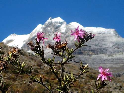
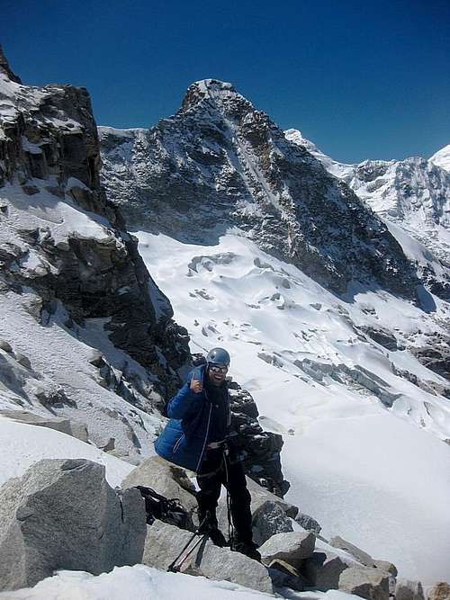
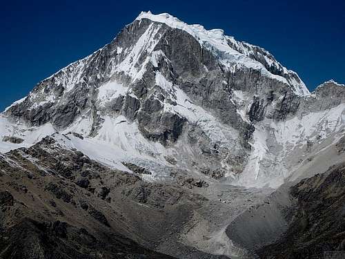
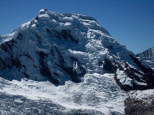
![Alpine flowers near the Ishinca trailhead - with Urus Oeste]() View from the trailhead: Alpine flowers against the backdrop of Urus Oeste
View from the trailhead: Alpine flowers against the backdrop of Urus OesteThe refuge
![mule train]() Our mule train on its way on the trail in the forest, still early on in the Ishinca valley.
Our mule train on its way on the trail in the forest, still early on in the Ishinca valley.
One mule would have sufficed for us...
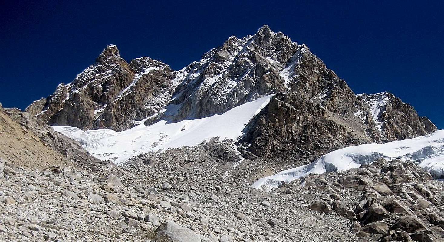
![Brilliant glaciers at the head of the Ishinca valley]() On the approach, the brilliant glaciers at the head of the valley come into view gradually, as if to avoid a sudden overdose of scenery
On the approach, the brilliant glaciers at the head of the valley come into view gradually, as if to avoid a sudden overdose of sceneryAfter a late start and an easy 3½ hour hike, Eric and I arrived at the Ishinca refuge, just before nightfall. It would have taken longer, had it not been for a chance encounter with an
arriero coming down the trail. We had planned to carry our packs ourselves, but although we had only been
A few words | Arriero | Mule driver |
| Este | East |
| Oeste | West |
hiking a few minutes when we met him, somehow they felt heavier than yesterday, when we packed them. On the spot, we decided to hire him.
At first, he tried to overcharge us a bit. That’s all part of the game, but I knew the usual rate and after a brief negotiation we reached an agreement. It would still be a welcome bonus for him, landing another client so late in the day. We waited a short while as he delivered his cargo at the trailhead, but he was back soon.
I teamed up with Eric after he responded to my post in SP’s Plans & Partners section. At the same time he also replied to the old fashioned note I had put up on the message board in Cafe Andino in Huaraz, not realizing it was both me.
He wrote that he was up for anything from easy up to TD+, and impressed me by listing Chacraraju as one of his long time goals.
I'm usually happy with anything up to AD, and occasionally a bit harder, but never climbed beyond D – so far. At the refuge, a couple of climbers had a pulse oximeter. Eric’s O2-saturation was 90% - considering we were at 4400m or so, that’s very good, especially since he had just arrived in Peru and this was the first climb of his trip. My own saturation was 91%, excellent too, but that was less of a surprise since I had been living and climbing at altitude for months by now.
On the other hand, his heart rate was much higher than mine. Not so high to worry about it though, and I put it down to his lack of acclimatization. And the hike might have contributed a bit too. It was time to get some rest.
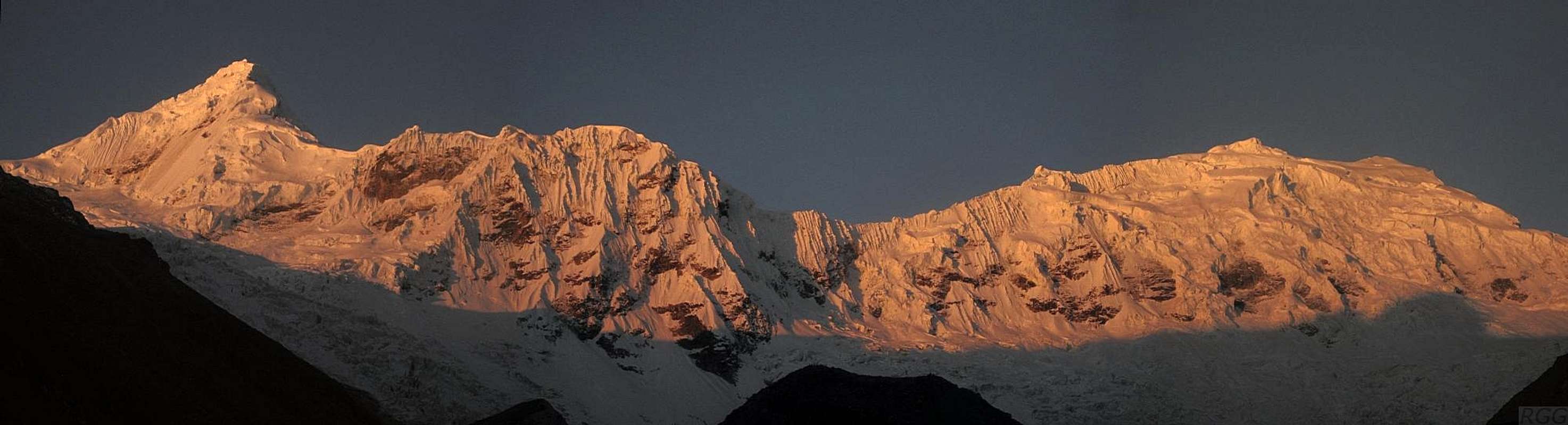
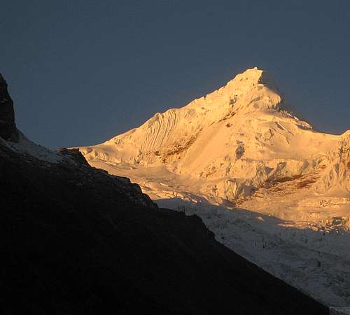
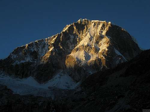
![Tocllaraju panorama]() Alpenglow on Tocllaraju from near the Ishinca refuge.
Alpenglow on Tocllaraju from near the Ishinca refuge.
Having climbed it nearly a month ago, it almost feels like coming home again now. And it looks every bit as beautiful as how I remember it!The longest day
The first mistake
For some reason, someone appeared to switch the lights in our dorm on and off. Eric was oblivious, but I woke up. I looked at my watch, and then I
really woke up! It was 5:48, I had overslept!
Still, no harm done. The previous evening I had asked the hut warden if I could have breakfast at 5:30. Flipping the lights must be the customary way to alert people there when they don't show up for it. I appreciated the service and got out of bed. The weather was excellent, and despite the small delay, it looked like we would still have plenty of time to carry out our plan.
![Urus Central and Oeste from Este, a few weeks earlier]() Urus Central from Este, almost a month earlier. As I only figured out much later, the flat one on the left is actually Urus Oeste.
Urus Central from Este, almost a month earlier. As I only figured out much later, the flat one on the left is actually Urus Oeste.On my previous visit to the Ishinca valley, I had climbed Urus Este to warm up for Tocllaraju. When you ask around in Huaraz which mountains people have climbed, you'll hear “Urus” quite regularly. It's a short and easy climb, perfect for beginners as well as for acclimatization. Only when you dig deeper, it turns out everybody means Urus
Este. Nobody climbs Urus
Central, and few people even seem to know it exists. However, at 5495m, Central is higher than Este, which is only 5420m. That made me curious: why do so many climb a subsidiary peak? For the record, there is another named subsidiary, Urus Oeste, at 5450m, and the map even shows a further summit to the north, at 5350m. Of all these, the refuge is closest to Este, lying to its southeast.
Although there is a small glacier high up on Este, I can testify that it is indeed an easy climb, and when climbing it nearly a month ago, we did not even feel the need to rope up. When I started asking around why nobody climbs Central, the only answer I managed to get was that it was difficult. Even when pressed, nobody could tell me
how difficult – was it just slightly more difficult than Este, or
really difficult? Nor could I find anybody who knew about the normal route. Not even on which side of the mountain it was!
I had explained all this to Eric, and said that I still would like to have a go at it. It would feel like pioneering, without any guarantee of success. He was keen to try, and so we agreed we would just go up there and see if we could find a way to the top on sight.
While climbing Este earlier, and especially from its summit, I had looked at Central, and that had given me an idea on where to start. We would head out on the trail to Este, to make light work of the steep lower slopes lining the Ishinca valley. After gaining a few hundred meters, we would leave the trail and generally aim for the saddle between Este and Central. Higher up, we would draw our plans based on what we would find.
In fact, I already had one route candidate to the summit of Central: the rocky east ridge from that very saddle, but from the summit of Este it had been too far away to judge how difficult it might be. On that first visit, armed with no more than what we surmised from the 50m contours on the 1:100 000 scale map, we had optimistically thought at the time that, after climbing Este by the normal route, we might perhaps traverse it and descend down to the saddle to the west and then continue to climb Central that way the same day – but looking down the rocky west ridge of Este to the saddle, we didn't like what we saw, so the traverse was out. Even if it hadn't been, it was already too late. But that trip taught me that to climb Central, forget about going over Este.
After breakfast, I woke up Eric, who preferred sleeping over eating, and by 7:30 we were on our way. We didn't know it yet, but we had made our first mistake: we should have started much earlier.
Route finding
Straight out of the gate, Eric went ahead. I checked my altimeter, and saw that I was ascending at a rate of almost 400m per hour. I thought that that was more than enough, considering that we already were at 4400m, but hey, if he wants to go faster, fine by me.
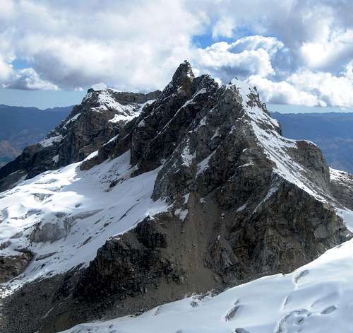
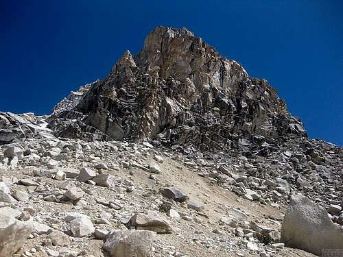
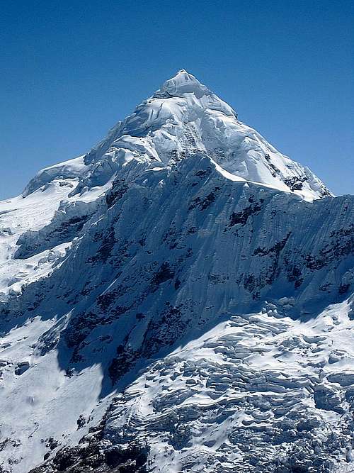
![Urus Central]() Urus Central - the eastern part to be precise - from around 4800m
Urus Central - the eastern part to be precise - from around 4800mIt only took a few minutes before he slowed down though, and the distance between us remained the same for a while. Occasionally I looked up to see where he was, but mostly I was watching the trail, to see where to put my feet, and I didn't pay much attention to him. Then, looking up one time, I saw that he had left the main trail, and was on a vague one more to the left. Although it was heading in the general direction of the saddle, it was rough, which made for slow going. I didn't like that, so I stuck to the easier main trail for the first hour, easily keeping him in sight in the open terrain, before heading left myself as well.
Finally I was aiming for Central too, or, more accurately, to the head of the small valley coming down to the south from the saddle with Este. Off trail now, I had to work my way through a field of big boulders, haphazardly strewn all over the place. That slowed me down, but since I had avoided most of them by staying on trail as long as possible, it didn't take too long before I reached the end of it. At around 4800m, the terrain leveled off and got real easy. It was relatively flat, with plenty of small streams of melt water and a few rocks here and there. Finding a fine camp site would have been no problem at all. Eric caught up with me – he blamed the rough terrain for the fact that he had been slower.
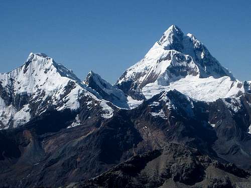
A little higher, we had a short rest, and studied the mountain to look for potential routes. Being closer, and for the first time getting a good look of the south side, we could see that Central itself actually has two summits, connected by what looked to be a sharp ridge running roughly east-west for a few hundred meters. The map didn't show that, it made it look as if there is only summit. In hindsight, that's no surprise, really, 1:100 000 is just not detailed enough for something like that. But we could see it ourselves now, it was plain as day. And that posed the question: which one of the two is the highest?
![Urus Central]() Urus Central from the southeast, shortly above 4800m. From this vantage point it's obvious that this is a complex mountain, but where is the true summit and how do we get there? The eastern summit, on the right, appears to be higher, but it's also closer, so maybe the western summit is higher after all? It's hard to tell. Our map, scale 1:100 000, is not much help either, showing only one summit.
Urus Central from the southeast, shortly above 4800m. From this vantage point it's obvious that this is a complex mountain, but where is the true summit and how do we get there? The eastern summit, on the right, appears to be higher, but it's also closer, so maybe the western summit is higher after all? It's hard to tell. Our map, scale 1:100 000, is not much help either, showing only one summit.
We studied the two summits, the ridge between them and the south face below it, but couldn't figure it out. The one on the right, to the east that is, looked higher. But it was closer too, so maybe the one on the left was higher after all? We just couldn't tell. The only thing we were sure of was that there wasn't a big difference between the two. We were hoping that it would get clearer when we would get closer, and on that thought we continued towards the saddle between Central and Este.
![]() Small man, big glacier - Eric below the saddle between Central and Este. We go left, avoiding the glacier.
Small man, big glacier - Eric below the saddle between Central and Este. We go left, avoiding the glacier.Before our climb, we had asked Eduard, the owner of the hostal in Huaraz where I was staying and himself an experienced mountain guide, about Central. He said that the glacier at its base was crevassed, and the route to the summit was not too difficult, but on poor quality rock. Based on that, we only brought one 50m rope, and hardly any rock protection. Purposely we didn't bring more, for unless it would appear to be easy, we had no desire to try a rock route that we didn't have any information about.
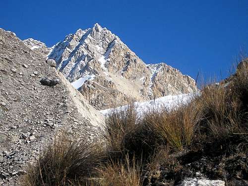
![Urus Central: a false summit on the SE side]() We are just south of the eastern summit of Urus Central now, with the saddle with Urus Este on the right. I estimate that it's about 300m to the eastern summit, but we're so close now that only the bottom part 100m or so is visible - look at the much larger image above to see for yourself. That same image also shows you can actually go around this lower bit, on either side.
We are just south of the eastern summit of Urus Central now, with the saddle with Urus Este on the right. I estimate that it's about 300m to the eastern summit, but we're so close now that only the bottom part 100m or so is visible - look at the much larger image above to see for yourself. That same image also shows you can actually go around this lower bit, on either side.
Without route information and not comfortable with the look of these rocks, we turned left, to the west. You can just make out the mixed slope that would lead us to the glacier south of the mountain.As we got closer to the saddle, we concluded that the eastern summit of Central seemed to be the highest point. We also we got better views of the rocky east ridge, obviously one of the shortest possible routes since it would lead directly from the saddle to the eastern summit. But we didn't like the look of it. Maybe we were too pessimistic and misjudged it – it wouldn't be the first time that a rock route proves to be easier only during the climb itself – but it didn't appear to be easy, and so we looked for alternatives.
The south face of the mountain was steep and snow covered, with rock coming through here and there. Relatively speaking, I'm more comfortable on steep snow and ice than on rock, and it looked like we could follow a system of snow packed gullies and ramps to the ridge. We would have to start in the middle of the face and go straight up. From our visual inspection, we reckoned that we probably could traverse a bit to the right a couple of times, to more gullies, which would eventually put us on the crest of the ridge close to the eastern summit.
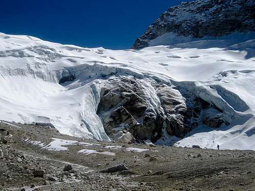
![Urus Central - the summit is on the left]() Finally we're on the gentle slopes of the glacier south of Urus Central
Finally we're on the gentle slopes of the glacier south of Urus CentralA glacier covered the gentle slopes below the steep south face. From the saddle between Central and Este another glacier flowed down to the south as well, but the two didn't quite connect. While we had aimed first for the saddle, then more directly to the eastern summit of Central, we were now just south of the latter, close to the base of the steep south face, but not on the glacier yet. Since we didn't want to climb the rocks, we couldn't postpone that any longer.
We turned west, and scrambled up a short mixed slope to get on the glacier. We roped up. It was not steep at all, just walking terrain. Contrary to our expectations, there were no signs of crevasses. Only further west we saw that the glacier was wilder and more dangerous, but we didn't have to go all that far. We just traversed west far enough below the steep south face to get to the middle of it, and I only saw one dangerous drop on the glacier close to our route. I committed it to memory, so we could avoid it on our way back.
![Eric at the base of Urus Central]() Eric at the base of the Urus Central south face, with Este behind
Eric at the base of the Urus Central south face, with Este behindThe south face
A small bergschrund protected access to the steeper terrain, but it wasn't wide, and we could have crossed it anywhere we liked. I chose the shortest route to the central gully – only to learn that, directly across the schrund, I faced a couple of meters of steep climbing. There were some helpful bits of rock, mostly covered by less helpful sugary snow. We had just one ice tool each, again based on the premise that we didn't want to climb something difficult without further knowledge of the route. But as it was just a few meters, I made short work of it.
After that, it was less steep again, and we could simply walk up. But soon enough the ramp got steeper, and the ensuing gullies even more so. As we progressed, there always was a way to get higher, but we found no easy way to traverse to the right. Ah well, I thought, we'll just get to the crest in the middle, and then follow it to the summit from there. Perhaps we should have looked harder for a place to traverse.
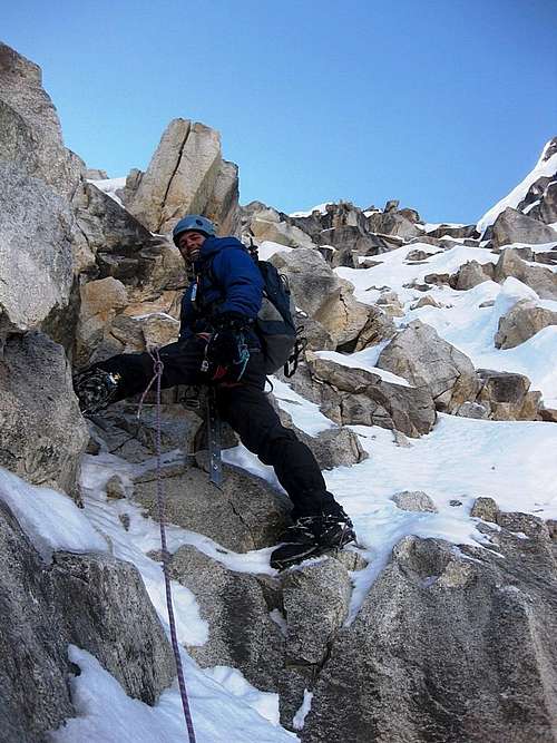
I led the first few pitches. I didn't place any protection, I basically climbed free. It felt easy enough to be confident that I would not fall. Whenever I got to a steeper part, I created an anchor to belay Eric as he followed, and then he would belay me from there while I tackled the next bit. That made for relatively short pitches, but we simply didn't bring enough gear for doing it any other way. Having a few more snow stakes and webbing would have been useful – but we didn't, as we had not really counted on climbing a steep mixed snow face.
![Eric leading]() Eric leading on the slopes of Urus Central
Eric leading on the slopes of Urus CentralWhen the next pitch looked a bit easier, I asked Eric if he would like to lead. For the first time, I got a good look at his climbing. Whether he was getting tired, suffering from the altitude or simply not as good a climber as I had expected, I don't know, but he was slow. It took him a long time to work his way up the next five meters, which I had thought were relatively easy. But then again, leading is different than following. Anyway, by the time I had finally caught up with him again at the next belay, an hour had passed, and we had only two hours of daylight left.
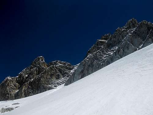
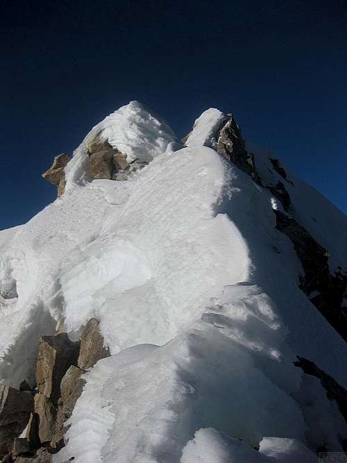
![Urus Central - summit ridge detail]() Looking east across a short part of the summit ridge
Looking east across a short part of the summit ridgeThat's where we made our next mistake: we continued. I took over the lead again for the following pitches, and in due course I reached the crest of the ridge – but still more or less in the middle, not exactly close to eastern summit. In fact, the western summit seemed closer, and looking back and forth I started wondering again which one was the true summit. Even though I wasn't sure at all by now, getting to the western summit would involve descending along the ridge and then climbing some steep rock, which looked well beyond our capabilities. So, true summit or not, I knew that we couldn't climb that, not from this side anyway, and so once more I returned my focus on getting to the eastern one. I followed the crest for ten meters or so, up to a point where a big rock on the ridge was blocking my way. That's where I decided to let Eric come up before looking for a way around or over it.
He joined me on my high perch. The views were great, and for the first time we could finally see down the north side. It was steep, and much less glaciated. That was to be expected, being on the southern hemisphere. The ridge itself was quite exposed, but we were comfortable with that. What we were less comfortable with, was our speed. From our position, following the jagged and exposed snowy ridge looked possible, probably, but by no means easy. We estimated it would take us at least one hour, more likely two, to cross it. Even the shorter estimate meant we would have to descend in darkness. And given the steep terrain, that was out of the question. We had to admit that we had reached the highest point of our climb.
Starting the descent
Up until then I had counted on downclimbing the route, possibly lowering Eric occasionally, but to save time we both rappelled from the big rock. Having only one 50m rope, that brought us down just 25 meters, but it was still faster. If you find yourself up there, feel free to use the webbing and the snapper that we left in place. However, given our limited amount of gear, I knew that we, or at least one of us, had to climb down most of the route anyway, so we couldn't make a speedy descent. Shortly below the ridge the terrain wasn't too difficult, so we both climbed down for a while.
On the way up, we had passed one particularly steep gully that I didn't look forward to climb down. Therefore, I opted for a slightly different route now, a little bit more to the west. It was easier indeed, until we got to the top of a steep, narrow, snow filled couloir. We looked for a way to avoid it, but it appeared to be the easiest way down. I was confident I could climb down safely, but it was tricky. The main problem was that the snow was pretty loose, so there was a bit of a risk of an unplanned slide. The gully wasn't very high, but it wasn't exactly flat at the bottom either, and a fall wouldn't stop there. In other words, an unarrested fall could prove to be fatal.
The second best option was a very steep ramp – not quite as steep as the gully, but too steep to walk down and without walls on the side to provide any holds for our hands or feet. We decided to rappel once more.
The flat section above the couloir was a relatively thin layer of loose snow on top of solid rock. We wanted to sacrifice a snow stake, but the powder was much too thin and too loose to be of any use whatsoever to build a useful rappel anchor. We swept away the snow, but didn't find any features on the rock below that we could use either. If only we had brought two ropes, we could have placed an anchor much higher up. But we didn't, and so we reluctantly concluded that rappelling wasn't possible. We then had a second look at alternative routes – but without the possibility of rappelling, the steep ramp looked even less inviting, and the only other way was up.
"Can you downclimb this?" I asked Eric, pointing down the couloir.
"I rather rappel", he replied after another inspection. And so we continued looking for a place to belay from, but the outcome was the same. Nada. Then Eric surprised me by changing his mind, saying
"I think I can downclimb this".
Losing Eric
![Alpenglow on Tocllaraju]() Alpenglow on Tocllaraju. Mind you, I was too busy and too focused on getting down safely to take photos during the descent; this is from yesterday
Alpenglow on Tocllaraju. Mind you, I was too busy and too focused on getting down safely to take photos during the descent; this is from yesterdayRelieved, but perhaps not quite thinking perfectly clear – it was starting to get a long day by now – I then make two more mistakes. First of all I believe him, secondly I start going down first.
Now that I am committed, I find enough places for my feet, but it still isn't easy. Fully focused, I make my way down to the bottom of the couloir. It doesn't take long at all, but as we had spent a lot of time above it, daylight is fading fast now. Visibility is still good, but it won't last much longer. Therefore I figure that I better use what daylight there is left to see how we can get down further, to where the terrain will be easy again.
As I make my way down; it's never really hard anymore. Mostly I can simply walk. Then, I reach a short vertical step, just over two meters high. Below it is broad snowy ledge, so I just sit on the edge at the top of the step and slide down the snow, wiping most of it off the rocks in the process. After that, the route proves to be twisting a bit, but it's easy going again. Not much further down I can see a clear way down to the gentle slopes south of the steep face. Taking this alternative descent route is no mistake: it is indeed easier than our way up had been. But where is Eric?
Will we ever get down?
I'm waiting.
No Eric.
The sun sets and it gets dark.
No Eric.
I shout something.
A faint response comes from much higher up the mountain.
I learn that he had started climbing down the couloir for a short bit, but then didn't see how to continue. And as time was passing by during his efforts to find a way, the sun went down, and in darkness it was even harder. In a nutshell: he got stuck. Not literally, mind you; ironically enough it's almost the opposite: the main problem is that the sugary snow offers hardly any purchase. The only way down is to use the rocks, but as they are partly covered in snow, even in daylight that already meant feeling a way down until something offered enough support, and obviously everything is slippery.
I'm thinking about his predicament. In my mind, I reckon, he just
has to find a way. I can't think of another way. He has our rope and some gear. Perhaps he can use that somehow? Of course, we had already tried that, and I have to admit that, while I climbed down myself, I didn't notice anything useful in the couloir either – but then again I hadn't been looking for it.
I'm waiting.
I look up the mountain and shout:
"Any progress?"
"What?"
"ANY PROGRESS?"
"NO!"
Apart from getting hoarse, we're not getting anywhere.
I start making my way back up, very carefully, well aware that I'm tired and climbing in the dark now – well, I have my headlight, but that's only useful for a short distance.
I reach the vertical step. Sliding down had been dead easy, but there isn't much to hold on to, and I don't have enough strength anymore to get myself up there. I rest. Try it again. I try various alternative routes around it, but all to no avail.
"Any progress?"
"What?"
"ANY PROGRESS?"
"Still searching!"
And so I try the vertical step once again, and more alternatives. All zip. Nothing. Nada.
My voice starts to falter, so now I just shout:
"OY!"
"YEAH?"
"ANYTHING?"
"I HAVE A BELAY, BUT AM NOT SURE ABOUT IT."
"WELL, DO YOU WANT OFF THIS MOUNTAIN TODAY?"
It's not that I'm at all angry or anything, but I'm not too sure about how that comes across. I simply mean it literally though, and it's my crude attempt to motivate him. I firmly believe he is capable of downclimbing that pitch – or am I fooling myself, and do I, perhaps just as firmly,
want to believe it?
"YES", he answers.
"THEN TRUST IT SOME, AND CLIMB DOWN".
By now he has been stuck up there for two hours or so. I've started to think we may have to spend the night out on the mountain. It isn't really cold, but we don't have much food and water. Still, I'm thinking, tomorrow I may have enough energy again to get up there, one way or another. With daylight I will be able to see where I'm going and I may find a different, easier way up. And if not, I can take the same route that we had ascended in the first place. But in the mean time, I don't realize that, in his predicament, Eric's night will be at best uncomfortable, and probably dangerous, as he is forced to choose between staying awake all night to avoid falling, or trusting his anchor.
However, finally things take a turn for the better: Eric starts moving! In fact, he rappels the steepest parts, trusting his own anchor after all. I'm very relieved when he joins me without further incident, knowing we now have the hardest part behind us.
![Ranrapalca North face]() A great view of the Ranrapalca north face from the base of Urus Central, much earlier in the day
A great view of the Ranrapalca north face from the base of Urus Central, much earlier in the dayI say,
"Let's get that rope down and continue. Do you want me to belay you down from here?"
"Yes... or, I think I can downclimb this..."
"Are you sure?"
Having learned something, we quickly agree that Eric will descend while I have him on belay, so if he gets stuck again, we won't have a repeat of the previous problem. Even though I figure it's easy enough, we are tired and it's dark now. Better safe than sorry.
"Ok, pull down the rope."
Eric pulls. I'm preparing the belay, when I hear him saying:
"It's stuck!"
"Oh boy". (
Feel free to insert a stronger expletive – I'm polite, and hardly ever swear)
"Murphy surely is on our side today!"
Eric tugs, swings and twists the ends of the rope, but it simply refuses to come unstuck. It's my rope and I'm not quite willing to leave it. Besides, we may need it to rappel after all, and we are on a glacier, in the dark.
Strangely enough, despite all our problems, I'm in a really good mood. I think it's because Eric got down after being stuck for so long. And then I get a bright idea.
"Hey, I couldn't climb up this vertical step earlier, but with the rope hanging here now, it's a completely different matter! I'll go up and get it".
It takes a bit of time, as Murphy has conspired to have the rope stuck behind a huge boulder just below where Eric had been sitting for so long, but eventually I get there and pry it loose. Once back down, I belay Eric while he follows the trail that I had made hours earlier. As he reaches the end of it, I come down too. From there we simply walk down together – as expected, there is no need to belay or rappel anymore.
Too late for dinner
Being a bit further west than on the way up, the bergschrund at the bottom of the south face was almost negligible. Once we were across, we took a break. We ate and drank a little from our dwindling supplies. Eric looked exhausted by now.
But while the most dangerous part was over, we still wanted to get off the mountain. We roped up again and started descending, Eric first. Going down was easy. Suddenly he stopped, and so I stopped too. I didn't know what was up, but he just stood there, nothing happened. I shouted
"I'm getting cold here!" He replied
"There is a big drop in front of me!"
I took it as a sign of his exhaustion that Eric couldn't think of anything else than just stand there. I walked up to him, and looked over the edge. He was right, it was a big drop. But more importantly, I recognized it even in the dark: this was the feature I had memorized! That meant I now knew exactly where on the glacier we were. In addition, from what I had seen on the way up, there would be few crevasses, if any at all, further down along the route.
I took the lead, and followed the rim of the big gap to go around it. That meant going up gently, but just a minute later we already got to the end. From there it was downhill all the way. Since I wanted to avoid the scrambling pitch at the point where we first got on the glacier, I didn't quite follow our original route now, but headed in a slightly different direction, leading away from the south face. Before long, we reached the edge of the small glacier.
Eric just lay on his back for a while, wasted. I took off my crampons and ate and drank something. He still wasn't moving. Since the boulder field ahead of us, at the edge of the glacier, looked rough, and I couldn't see far enough to be sure that it wouldn't get steeper again, we didn't unrope just yet. While Eric slowly came back to life, I walked as far as the rope would let me to have a look. But I still couldn't see far enough. I waited until Eric was back up, and together we went down again. We were slow, but still it didn't take long before I recognized the terrain around me – we were back on our ascent route. That meant there wouldn't be any difficult parts anymore, just tiresome, and we finally put away the rope. Eric rested again while I stuffed it in my pack and took off my harness. We were having lots of rest breaks. However, when I was ready to go again, Eric surprised me by announcing he wouldn't need any more breaks: he was ready to descend all the way from there.
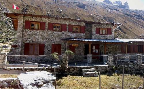
![Ishinca refuge]() The Ishinca refuge - photo taken on my first visit
The Ishinca refuge - photo taken on my first visitWe headed down the rest of the boulder field. As I had hoped, we soon got to the edge of the glacier flowing down south from the saddle between Central and Este. On our way up, we had stuck to the rocks right next to it, but I had seen it was quite harmless; no crevasses at all and a very nice gentle slope, which I now used to ski down on my boots. Eric quickly lagged behind – I guess he preferred hiking over skiing down.
After this fast bit, we reached the flat camping area. We followed one of the bigger streams down, making route finding real easy. However, once we got to 4800m, we found ourselves once more at the top of the big boulder field again. Having only our headlights to help us find a way, and being tired, hungry and thirsty, our already slow progress deteriorated to a crawl. I thought the easiest way would be to keep following the stream. We didn't stay very close together anymore, since the terrain was not all that hard now, just tiresome.
I looked around occasionally, trying to keep track of Eric. But the big boulders didn't make that easy, and soon I lost sight of him. Perhaps he had decided to rest somewhere after all, so I lay down to wait for him. After quite a while I saw a shape moving in the distance. He had apparently selected a different route: he was well on his way to the Urus Este trail, but much higher than where I planned to reach it! In a way it was funny, really: he would end up going down roughly the same way I had come up, while I was going down more or less along his ascent route! The only reason I didn't want to follow his route was that it actually meant going uphill for a while! I was simply too tired for that.
As we were now on different routes, there was no point in waiting any longer, so I got up and started moving. Eventually I reached the refuge at 3:12 am, Eric closer to 4 – a bit too late for dinner, unfortunately. Naturally, everybody was sound asleep, but at least the door wasn't locked.
Frankly, missing dinner isn't really a problem. I drink water and have a bite from my own supplies, but don't eat much. I'm too tired to be hungry. Too tired to sleep even, I think – but that's about the last conscious thought I have before I drift off.
The day after
Needless to say, we're having a rest day. I enjoy a slow and extended breakfast at 10, seamlessly followed by lunch. Having an early dinner gets thwarted by the extremely slow kitchen, and I'm sure my limited Spanish didn't help in getting my wishes across clearly.
As for our next plan? That would be to get up tomorrow morning at 3 am, to climb Ishinca! With a bit of luck, we're fast enough and still have enough energy afterwards. If we do, we'll hike out and get back to Huaraz.
Eric isn't feeling too good just yet though. Tired, obviously, but he also feels a knot in his back. As we turn in, he thinks he might not climb tomorrow.
Rise and shine!
At 3 am I hear the alarm. A few minutes later I get up and head towards breakfast, alone. I take my time for it. Just after 4 I'm ready to go, but, not surprisingly, Eric is not.
Going solo
As it happens, Ishinca is a very popular mountain, and not a hard climb. From what I had read about it, I felt confident to climb it solo. In fact, just yesterday we met a group of climbers that I had met earlier in Huaraz, and they had climbed Ishinca, so they could tell us all about the latest conditions. In short, I concluded, there was just one tricky section: a bergschrund just below the top, in a very exposed place. Apart from that I didn't expect any problems.
By 4:22 I'm out the door. I see head lights dancing in the distance. I feel good, but I pace myself, suppressing the urge to try and catch up with them. Nevertheless, one and a half hour later I do just that anyway. As the moment of sunrise approaches, so does the coldest moment of the day. It's not too bad though. I can leave my down jacket in my pack – today it's just extra weight to carry up and down the mountain. But it's better to have it and not to need it than the other way around...
![Early morning on Ranrapalca]() Early morning on Ranrapalca
Early morning on RanrapalcaI reach a small lake. Laguna Ishinca, I think. The trail comes to a junction. The one to the right is bigger; it has obviously seen more use, and heads in the general direction of the col between Ishinca and Ranrapalca, which is where the hiking route between the Cojup and Ishinca valleys crosses the mountain ridge. That is to say, it is usually advertised as a hiking route, even though it crosses a glacier. For me that's no problem though. I'm prepared for the glacier. But what does matter to me is that when hikers go there, there will be a trail, and it must be very easy going indeed. And so I ignore the lesser trail going left, even though a huge cairn suggests that is actually is the route.
Soon after the junction I arrive at the small bivouac building, at the edge of another, smaller lake. So that's where the trail went! On the map it looks the other way around: there is a small lake somewhat below the building – more precisely, two small ones right next to each other – while a much bigger lake lies next to the bivouac, and that's the one called Laguna Ishinca, not the lower one! Confusing...
But where do I go from here? After having a good look around, I see a trail that first leads away from the mountain, but then circles all the way around the northern edge of the lake before turning towards the saddle once more.
I'm a bit puzzled by the fact that that trail is much smaller now than on the way up to the bivouac. I thought that quite a few hikers would come over the pass, and then they would obviously follow the trail both sides of the bivouac. In addition, I expect few people would only hike up to the bivouac and turn back there. But I don't see another trail, so I figure it has to be right and I continue.
After skirting the lake the trail comes around again and now follows what looks like a big moraine extending from Ranrapalca. It gets more and more vague, until finally it peters away altogether. Did I get off trail somewhere? One way or another, it doesn't matter. I'm close to the gentle white slopes of the glacier, and it's obvious how to get there. Over a ridge, then down a short scree slope and I'm on the ice. It's hard. I still see no clear trail, but there is no fresh snow that might hide any crevasses. I put on my crampons and head towards the col.
The glacier isn't steep at all and I find it easy going. Before long I can make out a trail after all, a little bit higher than where I am. I aim for it. Before I get there, I pass a few crevasses, and I prod with my axe to check if they extend further than what I can see at first glance. Soon I reach the relative safety of the big trail.
The sun shines brightly and the scenery is fantastic, making me feel happy and warm, even though the glacier is still frozen solid. Notwithstanding the seemingly slow passage between the bivouac and the glacier, I'm making good time and steadily I get closer to the summit – but then, just before I'm there, I run into a serious problem after all: It's the bergschrund that I had heard about!
![San Juan and Huantsán from Ishinca]() San Juan and Huantsán from Ishinca
San Juan and Huantsán from IshincaAll along my plan is to traverse the summit. That means going up along the SW ridge and down by the NW face, but somehow I forgot on which side the schrund would be. Well, now I know. I'm standing right next to it.
It's not that wide at all, actually. I can easily reach across and touch the steep final slope, which I estimate to be just ten meters to the summit. But reaching is one thing, stepping across is a different matter: once I do that, I have to make sure I will cling to that slope as if my life depends on it – because it does!
It's the one and only point on the climb where I would have liked a second tool. However, I didn't bring one. Neither did I bring any gear for a self belay. My two options are clear: return or climb on.
Gingerly I test how solid the edge of the bergschrund is, and am happy to find it to be quite strong. So, I place one foot close to the edge, and in one continuous move I use the momentum and I swing my axe with all my strength, burying it into the slope on the other side. I trust the lip of the crevasse, but at the same time I'm fully aware that if I've misjudged it and it breaks away, I'll be hanging on that one axe. As expected, it's no problem though. I kick my other foot into the steep slope, bridging the schrund.
With one foot on either side of the crevasse and my axe as backup, I'm safe, but I don't feel comfortable enough just yet to step over completely just yet. If I did, I would then have to pull hard on my axe to get higher, and I if I can avoid it, I rather not commit all my weight to one point unless I really have to - and certainly not with that deadly gaping hole beneath me.
Therefore I look for something on the steep slope to grab with my free hand. Sure, there are steps, kicked by all the previous climbers on the route, but I'm not happy with those. But with my feet firmly planted on both sides of the crevasse, I feel safe enough to get my axe out of the slope.
It actually proves to be surprisingly hard work – I had really swung it hard when hammering it into the slope, and the reassurance that it would in fact have been fine to hang on to makes me feel good. Using my axe, I shape a simple grip for my free hand. That gives me an additional solid point on the steep slope.
![Pucaranra from Ishinca]() Pucaranra from Ishinca
Pucaranra from IshincaFeeling secure now, I hang my axe in the slope as well, then step across with my back foot, placing it on one of the steps made by all the earlier climbers. Fully focused I climb the final ten meters to the summit.
I'm happy that I encountered this on the way up – the thought of descending over that bergschrund without protection would surely have made me feel uncomfortable, to say the least. Had I come up the other way, I might very well have decided to go back instead of traversing the mountain!
But while so many things went wrong two days ago, today Murphy obligingly stays far away. He's probably still tired from everything he threw at us on Urus Central.
The actual summit is quite small, but I have it all for myself. Well away in the distance I see climbers approaching slowly – from both sides, actually. I have a long break, eating, drinking and enjoying the fantastic scenery. All around me are towering mountains, many higher than 6000m. I'm taking it all in - and try to recognize all the mountains near and far that I've climbed since arriving in the Cordillera Blanca.
I thought the first group arriving from the NW would arrive sooner, but their progress is slower than I had expected. I figured I would make room on the top for them when they would get there, but they take too long. As I still have a long way to go today, I decide it's time to get down.
![Tocllaraju from Ishinca]() Tocllaraju seen from high on the NW slopes of Ishinca. The normal route follows the NW ridge, on the left
Tocllaraju seen from high on the NW slopes of Ishinca. The normal route follows the NW ridge, on the left![A sideways view of a hidden crevasse along the NW route on Ishinca]() A sideways view of a hidden crevasse along the NW route on Ishinca. Makes you think, doesn't it? What if you approach this crevasse from any other angle? It looks as if you might not see a thing, before you fall into it...
A sideways view of a hidden crevasse along the NW route on Ishinca. Makes you think, doesn't it? What if you approach this crevasse from any other angle? It looks as if you might not see a thing, before you fall into it...
With the exception of the short final bit, ascending the SW ridge had been very easy. The NW slopes are not hard either, but the route is more varied and has a couple of slightly steeper sections. Although it appears to be possible to walk down all the way, on a couple of occasions I prefer the safer alternative of turning around and climbing down.
Without incident I reach the edge of the glacier, about an hour after starting my descent. The landscape was, and still is, beautiful, but I'm glad I can finally take of my crampons and loosen my shoe laces. I had them very tight, and my left ankle was suffering a bit from it.
From the glacier to the lower lake, which, earlier that day, I thought was Laguna Ishinca, I go cross country. Perhaps there is a trail, but I don't see it – nor do I need it. The terrain is open and not really steep, so you can go wherever you please. I do see the occasional cairn though, so I must be doing something right. The very shallow lake is fed by an extensive delta of glacial streams, and the cairns point to a place where I can cross easily. Not long after that I'm back at the big cairn and the junction where I had gone up the other way several hours ago.
All I have to do now is hike down the big trail, back to the refuge. And look around to enjoy the big mountains. I love looking at the impressive shape of Tocllaraju, bringing back great memories. And I intently study Urus Central, with the recent impressions of our failed attempt vividly in my mind. After looking at it a whole lot on the way down, I'm finally convinced that the eastern peak of Urus Central is not the main summit – the western peak, while still marginally further away from this angle, definitely looks higher now.
![Urus Central and Urus Este from Laguna Ishinca]() Urus Central and Urus Este from what I first thought was Laguna Ishinca, near the junction of the SW ridge and NW face routes to Ishinca itself
Urus Central and Urus Este from what I first thought was Laguna Ishinca, near the junction of the SW ridge and NW face routes to Ishinca itself
That clinches it: if I ever have another attempt at Urus Central and I still haven't managed to get my hands on a useful route description, I now know that climbing the steep south slopes to the crest of the ridge between the two peaks may be an interesting route, but it's no good if you want to get to the summit – unless I have a more accomplished rock climber as partner perhaps. Thinking about it makes me wonder if anybody even attempted our route before...
Despite all the pictures I take, I make a fast descent and find myself back at the refuge well before one o'clock. All in all, my descent doesn't take much more than 2½ hours. That means I have lots of time to eat. Eric is resting. I say we can stay another day if he wants to, but he feels good enough to hike out. We take it easy – and so does the staff at the refuge, taking an hour to sort out our bill after we mention that we didn't have dinner the day we tried climbing Central, so we don't want to pay for that. But hey, who's complaining, it's a holiday!
Epilogue
Although we made quite a lot of errors, and didn't even get to the summit, we both really enjoyed our climb on Urus Central. Well, during the descent perhaps not so much, but we look back on it as a great experience.
It was also one of the most educational mountaineering experiences I've had, not just in Peru, but anywhere. While some of the mistakes only diminished our chances of getting to the top, others could have had serious consequences.
![Urus Central route sketch]() The solid line is a sketch of our ascent route, the dotted one the descent variation.
The solid line is a sketch of our ascent route, the dotted one the descent variation.
I didn't record this, but reconstructed it much later, based on my notes and maps.- We should have turned back at least an hour earlier. Apart from being a bit lower, that would have given us an extra hour of daylight to get off the steep south face. As it was, we would still have had enough daylight for it if we had not run into trouble. But we did, and the darkness made it worse.
- The main mistake happened on the descent, at the top of the couloir. When Eric changed his mind and pronounced that he could climb down the couloir, I believed him without reservation. Sure, I had never climbed with him before, but during the ascent I had concluded that I was the stronger climber. In hindsight, it would have been safer if I had wedged myself somewhere at the top of the couloir and kept him on belay while he climbed down, after which I could have climbed down myself. But I didn't think of this until it was much too late. We were lucky that he managed to climb down safely eventually – the consequences of a fall don't bear thinking about...
Obviously, a mistake such as this is much less likely when climbing with someone you know well, but that's not always the case. So, since then, when climbing with someone I don't know very well, I try to pay more attention to my partner's skills.
Since we climbed the face without a route description – and I haven't found one since then either – I can give only my own estimate on the difficulty of the route. Although it was steep, we climbed it without too much trouble with just one ice tool, so it must be easier than AD. At the same time, it felt harder than most PD routes I've climbed. Consequently I estimate it to be PD+.
Mind you, that's only to the crest of the east-west ridge, not to the summit. Getting there definitely looked harder. And for all I know, the easiest route to the summit may be on the other side. I'm now thinking that perhaps the rocky west ridge is an easier way to the Central summit. Anybody interested?
The story continues here: From a disaster area and getting robbed, to a beautiful climb
![Annotated view across the Ishinca valley]() Annotated view across the Ishinca valley, from high on the SW route to Ishinca near the col with Ranrapalca.
Annotated view across the Ishinca valley, from high on the SW route to Ishinca near the col with Ranrapalca.
6 km to the northwest, Urus Central is very clear. Today, the east-west summit ridge looks much more jagged and the south face much less glaciated than it had from up close, two days ago. Also, from this photo it is pretty obvious that the western peak of Urus Central (on the left) is the true summit.
By the way, don't let this view fool you into thinking that Copa or Huascarán Sur are close: Copa is almost 16 km away, Huascarán Sur about 37 km. These mountains are huge!


Comments
Post a Comment