
-
 2088 Hits
-
 77.48% Score
-
 8 Votes
|
|
Mountain/Rock |
|---|---|
|
|
37.77411°N / 107.8408°W |
|
|
San Juan&San Miguel |
|
|
Hiking, Mountaineering, Scrambling |
|
|
Spring, Summer, Fall |
|
|
13260 ft / 4042 m |
|
|
Overview
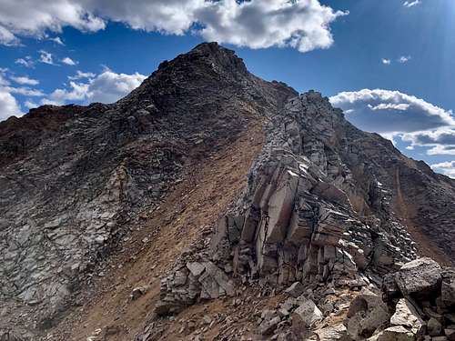 North Ridge V 9
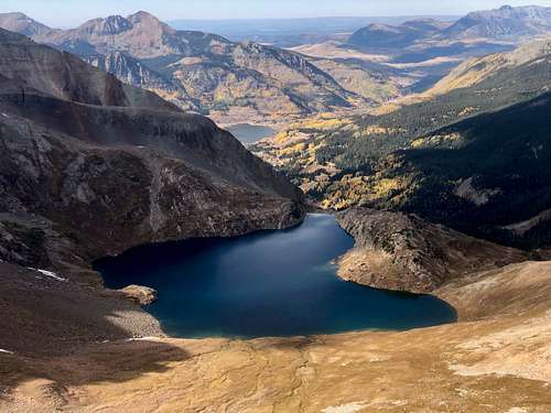 Lake Hope
There are 2 easy approaches and both are mostly on a trail. I chose to come via Hope Lake trail from the west (Hope Lake is very scenic). You can also come from the east via South Mineral Creek Trail.
Why V 9? V means the peak in the old 15-minute Vermilion quad. So, there are many peaks starting with letter V and numbered.
V 1 12,935 Unranked peak, rarely summited
V 2 13,309 CO rank 387, great hike and views, technically easy class 2
V 3 13,528 CO rank 238, more challenging at class 2+, loose gravel, great views
V 4 13,540 CO rank 228, loose terrain, class 3, incredible views into Ice Lake Basin
V 5 13,156 CO rank 518, often climbed with South Lookout Peak, class 2+
V 6 12,442 CO rank 1041, bushwhack to the summit, pretty sort.
V 7 13,042 CO rank 612, technically easy, grassy slopes (read a report about a person mountain biking this one).
V 8 don't ask me what happened to this one...some resources use UN 13300 as V 8 (Gerry Roach) and other use West Turkshead Peak.
V 9 13,269 CO rank 435, class 3, nicely located above Hope Lake. Great area to explore.
V 10 13,475CO rank 271, class 3, willows, very loose terrain. ![V 9 summit]() V 9 summit with Rolling Mountain in the background.
V 9 summit with Rolling Mountain in the background.
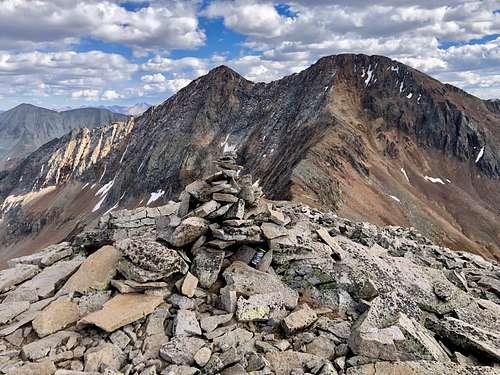 V 9 summit with Rolling Mountain in the background.
 Colorado Rank: 435
Quad: Ophir
Parent Lineage: Line Parent: Rolling Mountain Proximate Parent: 13300
Class: 3
Nearby Peaks:
- Unnamed 13300 0.82 miles
- Rolling Mountain 0.99 miles
- San Miguel Peak 1.34 miles
- Beattie Peak 1.41 miles
- Grizzly Peak B 1.70 miles
- V 10 1.80 miles
- Fuller Peak 1.84 miles
- Vermilion Peak 1.87 miles
- Golden Horn 2.28 miles
- Pilot Knob A 2.67 miles
- Twin Sisters West 2.72 miles
Getting There
 Lake Hope with a slight snow fall
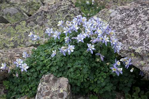 Nice columbines - Lake Hope has nice wildflowers in July/August.
 The trail is well used and really easy to follow. It is 2.5 miles to the Lake, and another 0.3 miles to reach the pass. Trailhead elevation is 10,750 feet, Lake Hope is 11,880 feet and the Pass is 12,445 feet. The views are spectacular!
Bandora Mine Trail via South Mineral Campground: nice if coming from the east (Silverton area). Drive north of Silverton for a couple of miles towards Ouray on Million Dollar Highway. At the sign for the South Mineral Campgroung, turn left onto a good dirt road. In 4.3 miles, pass the Ice Lake Trailhead. The next two miles require high clearance 4WD vehicle. Park in a turn out at 6.6 miles at the Bandora Mine. The road splits here - the left branch goes down to the South Fork of Mineral Creek (good access point for Twin Sister Peaks and Rolling Mountain), and the right branch is closed to vehicles and goes up Lake Hope Pass.
As mentioned in an Overview section - basically, it does not matter which approach you choose. The goal is to reach Hope Lake Pass and here both approaches meet and you climb the south ridge of UN 13000. I chose Hope Lake approach because we got fresh snow and I expected the drive to Hope Lake Trailhead easier. Hope Lake trailhead is passable for 2 VD vehicles. If coming from the east via Bandora Mine and South Mineral, you do need a 4WD (ok for 2 WD to South Mineral campground, then the next 2 miles are rough).
Route
I chose to approach via Hope Lake Trail since it is scenic, does not require long 4 WD road (normal cars can make it), the area around the lake is very scenic and the trail is easy to follow. The trailhead is well marked, the distance to the lake is about 2.5 miles. The trail continues higher up to the saddle between 13300 and V 9. I left the trail at the saddle and ascended initially easy north ridge with some looser sections. There is loose rock, consider a helmet especially if going in a group of people I stayed pretty much on the ridge except 2 occasions when I bypassed the technicalities once on the west side and 2nd time on the east side. Never descended more than 15 feet. The summit has great views especially over to Rolling Mountain, Grizzly Peak and V 10, San Miguel and north views towards Vermilion group. Hope Lake looks fantastic from here.
Red Tape
Driving 4 WD roads, hiking and climbing are free.
When to Climb
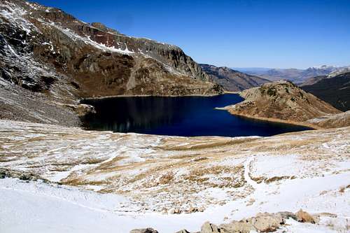
Summer is the easiest with a relative short access. Winter is easier from Lake Hope since the approach will be shorter. Check for avalanche reports prior venturing out in the winter. Lake Hope area is a very popular hiking destination, especially during the summer expect crowds, beautiful blue waters of the lake and tons of wildflowers.
Camping
You can sleep in the car at the Lake Hope trailhead (there is an overflow parking also). The road to the trailhead has several pull out parking areas with nice camping (primitive, flat, fire rings built out of rocks).
South Mineral campground is open seasonally and paid camping area with vault toilets. You can also sleep in a car around Bandora Mine or set up a campsite at the south fork of Mineral Creek (primitive, but beautiful and free).