Pico de Orizaba has been weighing on my mind for several years now. Originally, I had planned for a 2008 attempt, but my climbing buddies weren't able to come along so I postponed. In 2009, my friend Robbin, whom I met purely by chance when hiking in the Olympic mountains, told me she and her friend Mike where planning a trip to Mexico. An invitation to join them followed and soon I was committed to an attempt of the Mexican Volcanoes. Our plan was to start with the highest peak (Pico de Orizaba originally named Citlaltepetl which means Star Mountain) and work our way down, tagging as many summits as possible in 10 days. The second objective would be
Iztaccihuatl which means "sleeping woman". The profile of that mountain is said to look like a woman laying down. Although our plans were flexible, one thing was certain, no matter how many days it would take us, Mexico's highest was our number one objective.
We arrived in Mexico City the afternoon of November 11th. Supposedly snow conditions on the Jampa Glacier are best in November. After several long bus rides we came to the small town of Tlachichuca. Mike had made reservations for us at the residence of senior Joaquin Limon. In hindsight, Mike's ability to speak basic Spanish was the biggest asset to the trip. He orchestrated all the communication sessions and never tired of acting as our interpreter. I'm very grateful to him.
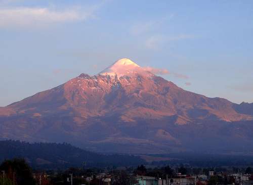
Citlaltepetl / Pico de Orizaba - 5636 meters - 18,490 feet
Since the three of us live near sea level, we had some minor concerns about an immediate drive up to 14,000 feet. Wanting to maximize our chances of success and acclimatize properly, we agreed to spend two nights in Tlachichuca at 8530 feet. We spent our first full day in Mexico walking around town, exploring the church and local vendor's goods.
On the morning of the 13th, Senior Limon and his son drove us up to the Piedre Grande hut, dumping us and our mound of gear at this famous locale, where climbers from all over the world assemble to test their personal strength and endurance. I met Germans, a few other Americans, and a Canadian. But the majority of the climbers were Mexican and very excited to be there. All of them asked, "Is this your first time on Orizaba"? I couldn't help but think this is like their Mount Rainier.
![Traffic]()
After pitching our tents near the Piedre Grande, we set out for the first acclimatization hike up to 15,000 feet near the base of the Labyrinth. We were following the suggested model for high altitude climbs, hiking high during the day and sleeping lower at night. Many people come into Tlachichuca, drive directly up to 14,000 and then push for the top the next morning. It is possible to summit this way but your chances of getting AMS or one of the edemas is greatly increased. We wanted to take our time and be sure that we all made it safely to the top.
![Loose Rocks]()
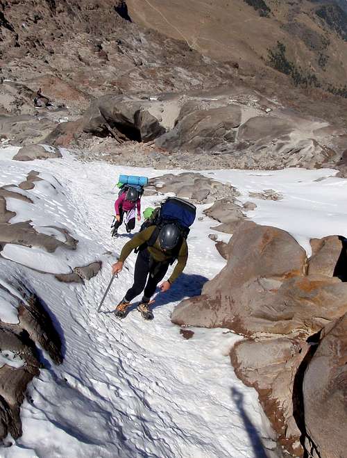
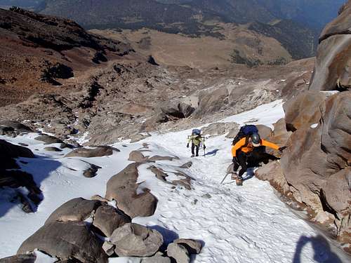
Above the hut we walked on top of an old aqueduct which I initially mistook for a cement pathway. When the duct terminated we stepped off onto loose sand and scree intermixed with talus. I quickly learned that you don't trust rocks of any size on Orizaba. Even if it looks anchored to the ground, the smallest nudge could be enough to set it loose. We followed a maze of crisscrossing paths up the dirty ridges to the first of three options for high camp. From there we could see the part of the route known as the Labyrinth, and to the right of it, massive Sarcofago Rock (16,667 feet).
![Inside the Labyrinth]()
The Labyrinth is a maze of rocky slabs and ridges where the glacier has receded. It ranges between 30 and 60 degrees depending on which way you ascend. During some seasons, these rocks are interspersed with mixtures of ice and snow. At other times they may be completely melted off. Every time we came through the Labyrinth we seemed to be on a slightly different variation of the way before. Only on our last descent from the mountain did I feel like I was really familiar with the best route.
![In The Labyrinth]()
For a lack of oxygen, the first hike had been trying even without carrying any weight. Believing this would gradually let up, we descended to base camp with high hopes. The next day we loaded our packs with dehydrated food, extra water, and cold weather clothing. We would leave a cache at high camp near the base of the Jampa Glacier and then come back the next day with the rest of our gear. We decided to make the last camp as high as possible and thus make summit day a little easier. On the way to the Labyrinth I noticed that Mike was calling out for frequent breaks to sit down and rest for a minute. Picking my line through the rock, I tried to follow the snow patches that showed the greatest number of boot tracks.
![Inside the Labyrinth]()
We were eventually funneled into a steep snowy couloir. The snow was quite hard and boots were not enough to gain purchase. Being lazy, I avoided breaking out the crampons by scrambling up the rocks along the north side of the couloir. Mike and Robbin stopped to put theirs on. Half way up the couloir I ran out of handholds and was forced to break out the axe and cramps as well. We followed good snow up and over the last ridge and then we were there.
High Camp! The big old snow cone and Sarcofago Rock were really looming large from this vantage point. It was going to be a great camp. We emptied our packs and chose a small hollow downhill from a boulder to cache our gear. I put the water bladder at the bottom and piled everything else around it, lastly covering the cache with heavy stones. I wanted the water to be insulated from the nocturnal
katabatic winds coming off the Jampa Glacier. Otherwise when I returned to camp I would have a nice big 3 liter ice cube waiting for me.
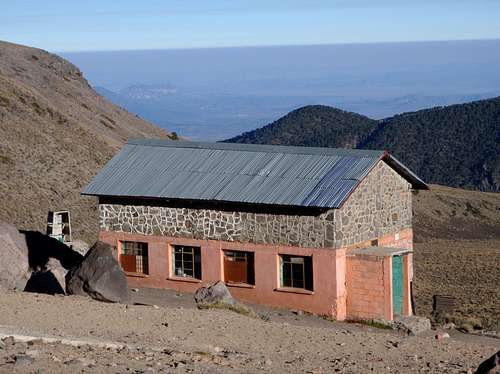
Descending from high camp I tried to follow our tracks, but we came down a different way, which was less direct. Mike and Robbin kept their crampons on sticking to the snow. I kept mine off sticking to the rocks. Once we were out of the Labyrinth I led the way down the loose slopes trying to stay on track. Once again we descended on a new path which was steeper and looser than the one we had come up. After dusk, the cold chased us into Piedre Grande to do our cooking and eating. We tried to be quiet while 3 tiers of tired climbers slept all around us.
![Piedre Grande Hut]()
The next morning we packed up the rest of our gear leaving only a few items behind in the hut. This was it. We were moving up to high camp and would not return until we had reached the summit. Looking down at the rocks and sand, I wondered how I would feel the next time I passed this way, having a new summit under my belt. I noticed that Mike was panting again and it made me wonder if he was acclimatizing properly. He even commented "you guys aren't even breathing hard". Altitude can play the devil's advocate sometimes and you can never be sure who or when it's going to strike. In the past I've gotten very sick making camps just barely over 10,000 feet. Several times at Ingraham Flat on Mount Rainier I've spent a sleepless night with a pounding headache and relentless nausea. At other times I've had no issues whatsoever near 20,000 feet. Proper rest, hydration, and food intake seem to be key. But there was no question about it now. Mike's frequent calls for a break were unusual signs of fatigue. Normally Mike is a strong member of the group. I had my first doubts about our chances of success. I was given a new piece of information. Mike hadn't had been able to sleep since we had been on the mountain. Two nights of laying awake. Not good.
![Mike]()
This time I put my crampons on at the base of the couloir. We reached high camp at 16,300 feet. To my great relief, I found my 3 liters of water very cold but not an ice cube. Nobody had disturbed our gear cache either. We set up camp and began the long process of melting snow and filtering more water. After dinner, we retired to our tents with an alarm set for 2:30 AM.
![Inside the Labyrinth]()
The night before a summit attempt is a strange time for climbers of large volcanoes. Even as a member of a team, each climber is very much alone when contemplating his chances of soon standing on top of the mountain. Alternating thoughts of excitement, fear of the unknown, joy, and personal doubt cycle rapidly through the mind. I was laying there encased in a cocoon of down and synthetic fabrics while the temperature in the hostile environment outside my tent dropped well below freezing. At high camp, there was no visible sign of any living thing, except us. I dreaded that moment when I would have to leave the comfort of my warm den and step out into cold. But I couldn't wait for that moment when all my efforts came to fruition and I would be standing at the top of Mexico, Citlaltepetl, the third highest peak in North America. With these thoughts I drifted off for a few hours.
![Altitude silliness]()
November 16, 2:30 AM, I heard Mike and Robbins voices faintly through my earplugs. This was it, today or never. I started to get ready, procrastinating that moment when I would have to get out of my sleeping bag. I asked Mike if he had gotten any sleep and he said no. Damn! Three nights in a row. At 3:15 AM we were ready and moving along with headlamps. I led up through some small moraines and we found the terminus of the Jampa Glacier. We donned the crampons and began a slow and steady pace, breathing hard.
Pressure breathing and rest stepping was a big help. The snow was very firm but not icy. Perfect would be the proper word. I noticed with interest that the other crampon tracks moved straight up the face without any switch-backing action. We followed them but it was slightly frustrating at 45 and then 50 degrees when I knew that an ascending traverse would be easier.
![17,500 Feet]()
Mike seemed to be struggling with the physical exertion but he also seemed determined and I had hope for him. I couldn't see it in the dark but Robbin later told me that he had been climbing the whole time with his eyes closed. At 17,500 feet, he stopped and three of us talked for a while. He was not doing well. Now the fatigue was extreme and he said "I just want to go back and get into my sleeping bag". Worried, I said "hey man, remember that the summit is only half way. If you're not up to it, don't put yourself in jeopardy". Mike said he didn't want to keep me from making the summit. Robbin said she was going to go down with him, a very noble move. If I had known that he had been climbing with his eyes closed, I might have been more concerned for him and gone down with them.
![3 Climbers]()
After a few minutes a talk they were quickly descending and I was all alone on a 50 degree snow slope in the dark. But hey, this was my dream, and the mountains are my passion. I was in my element and though I was lonely, I felt comfortable with the terrain. A half hour later, I started to sing The Yellow Submarine by the Beatles. I found that I could only get out a few words each time before gasping for air. It was likely the worst rendition of a Beatles song ever, but it made me happy. I tend to sing this song at weird times in my life, like when I'm sitting on the floor of a large tent on the edge of the Sahara Desert, surrounded by Algerians sitting around a candle. I continued to take one step at a time, slowly. I could feel the strength in my legs wanting to go faster, but my lungs just wouldn't allow it. I was now climbing in roughly half the air I had grown accustomed to living at sea level. Around 18,000 feet I was only taking a few steps at a time but my heart was racing trying to catch up and my vision was pulsing with each pounding heartbeat. I forced myself to slow down even more.
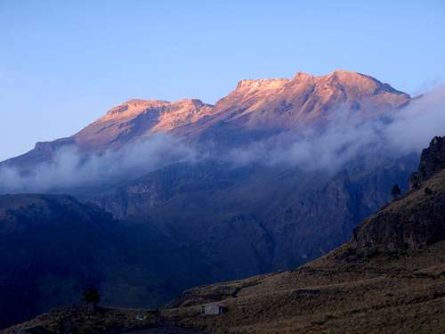
![Orizabas Shadow]()
The sun was just below the horizon and it painted a long line of yellow and orange below the brightening sky. The crater rim came into view above and I knew I was getting close. I could see sunlight touching the edge of slope. When I reached the rim I knew for certain that success was mine. I paused to take some photos of the crater. I wished that I could see the bottom but it was too deep and there was no safe vantage point to look down from. I followed the rim top up and to the south catching a glimpse of the crosses on the top and then I was there. 7:15 AM , nowhere higher to go.
I was alone on the Summit! To the east, many thousands of feet below, there was a sea of clouds far out over the Atlantic Ocean. To the south, on the summit of neighboring
Sierra Negra, I could clearly see the
Large Millimeter Telescope, one of the highest on earth. The shadow of Orizaba stretched out over the Mexican plains, covering Tlachichuca. In the far distance I could just make out
Popocatepetl and Iztaccihuatl, the second and third highest peaks in the country, also volcanoes. Popo, for several years, has been experiencing frequent and unpredictable mini eruptions and is therefore illegal to climb. For that reason, Izta would be our next group objective. I spent a half hour taking photos and eating while the sun warmed my face. I felt the joy of my accomplishment but I regretted not having Robbin and Mike there to share the moment. It wasn't fair that Mike's dream had been seized by altitude sickness. I hoped that we could at least stand together on the summit of Izta. Up there on the summit, a couple of times I could have sworn that I heard voices nearby but I couldn't make out what they were saying. There was no one in sight. I took one last look around at the 360 degree view, knowing that I would probably never see it again, then I started the descent.
![Success On Orizaba]()
On the way down I passed scores of Mexican climbers. Several of them asked me why I was alone. I told them about my companions. What had taken me 3.5 hours to come up, only required 2 hours to come down. By 9:30 AM, I was back at high camp and Robbin expressed her surprise to see me so early. Both her and Mike expressed their happiness that I had made it. Without words, a strange mix of emotions passed between us. I was prepared to start packing for the descent to base camp but Mike and Robbin mentioned the possibility of staying another night and trying again the next AM. I was alright with that. Later in the day Mike decided that after 3 nights of sleeplessness he was unlikely to sleep on the 4th night either. He tried to reach Joaquin on the radio to schedule a pickup but was unable to get a response. We played rummy in the tent and then spent another night at 16,300 feet.
![Enjoying Sunrise]()
On the 17th I awoke to one of the more spectacular sunrises with the sea of clouds down below. Mike and Robbin were already outside mopping it up with their eyes. It was a special moment and a good way to start our last day on the mountain. 5 days on the mountain. It was my second longest expedition to date. We now had a limit amount of time for the smaller peaks. Back at base camp we found Joaquin waiting for us. During the rolling and shaky ride back to town, the three of us discussed the adventures we had undertaken during life and the ones we still hoped to try some day. We spent one last night at the Limon residence.
Iztaccihuatl - 5230 meters - 17,175 feet
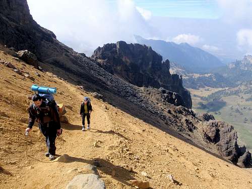
In the morning we caught a series of buses to Amecameca, the staging point for Izta. Apparently there is no direct way to travel from Tlachichuca to Amecameca, but Mike was able to ask the right questions and get the right answers. Again I expressed my gratitude to him for his skill in the Spanish language. At the park office downtown, we obtained printout maps from the officials and permits for the following day. We scheduled a taxi driver to pick us up well before dawn to make the 2 hour drive to La Joya. We wanted to enter the park as soon as the gate opened. According to the map we were given at the permit office, the standard route named The Ridge of the Sun or "La Arista del Sol", was only 11 kilometers round-trip, just under 7 miles. I was stunned. For such a huge peak this was a very short distance. We should be able to do it in a day. I double checked the copies of the route I had made from R.J. Secor's guide book Mexico's Volcanoes. There was no mention of the distances on the route.
![Iztaccihuatl 17,195ft]()
The ride up to the park entrance at the
pass of Cortez was uneventful. The state of the visitor center was embarrassing to say the least. At La Joya, the ground was covered in frost. We told our driver "hasta luego" and started up the trail. Our pickup time was scheduled for between 7 and 8 PM. We would have to be back to La Joya by then or be left on the mountain. That allowed us just under 12 hours for our summit bid. We travelling light with just a minimum of emergency gear. At the second major pass along the ridge we stashed some of our emergency gear and reduced down to two backpacks for the three of us. The mountain was really dazzling us now with yellow and orange slopes of dirt scattered with black lichen covered rocks. The rock formations were also very impressive, better than I had expected. Clouds were swirling around us creating an ethereal ambiance and I commented that the landscape had taken on a Martian quality.
![Ridge of the Sun]()
Having slept good for two nights, Mike was back to his usual self and keeping a good pace with me and Robbin. Feeling the altitude, we reached the "Grupo de los Cien hut" (group of the 100 hut). Among the rock formations around the hut, there were many metallic crosses affixed to the rocks. Some Mexican custom allowed all these memorials to be placed up here on the mountain. It was eerie to watch the fog move in and out of the crosses. I wondered if all these people had perished on this mountain or if this was just the site that their loved ones had chosen for memorial. I stared at the slope ahead with some confusion. There were several paths leading up to the next pass. I decided to follow the most defined one. It took us 40 minutes to make it to the next pass, panting and gasping for air.
![Group of the 100 Hut]()
When we got to the pass, Mike called for "powow". He voiced a concern that had already been growing on me. It was 1pm and we had decided that our latest turnaround time would be 3 PM. On the map, Grupo de los Cien was only half way to the summit. Something was wrong, we weren't going to make it at this pace. Instinctually, I felt this truth sink in, but I still had hope for success. Mike and Robbin looked at me once again and I thought "no, not this situation again". But they were right. After a few minutes of talk we decided that they would wait for me at the hut while I made a last ditch effort for the top. I knew I could go a little faster on my own. I promised them that I would turn around no later than 3 PM. They said "be very careful and come back to us".
![Yellow and Blue]()
Scrambling on the cliffs above the pass, I couldn't seem to find the safest line through. I knew that this route should not exceed class 3 but I kept encountering class 4 moves. I scrambled up on the north side of the ridge. When that failed I tried the south side. Same problem. I thought "where the hell did the route go"? I looked closely down at the scree slope below the cliffs on the north side, trying to detect any signs of the route. I couldn't see any boot prints or hint of a path. I knew I was quickly running out of time. Actually it was already too late. Wasting 20 minutes searching for the way had sealed the deal. I struggled with myself on the inside trying to let go of the goal. Rather than spend another hour exploring route options, I returned to my companions to sit and eat in the hut. Near the hut I saw another path I had not noticed before leading down through some talus and around to the side. You can see in
MOCKBA's photograph what we were facing. The blue line is what we followed up to the cliffs and the red line the what I saw later.
In the hut there was a heavy sense of double defeat. Some jokes about near misses were made to raise moral but truthfully it was a hard pill to swallow. After eating we turned back the way we had come, not stopping until we came to the gear cache. Back at the parking lot we waited just over an hour for our driver to show up. Inspecting the GPS readings we discovered that we had gone over 7 miles throughout the day. That meant that the distances numbered on map were only half of what the true distances were. That night, walking the streets of Amecameca, I ate 10 tacos and 1 tamale cooked by cart vendors. They were the best I had ever had.
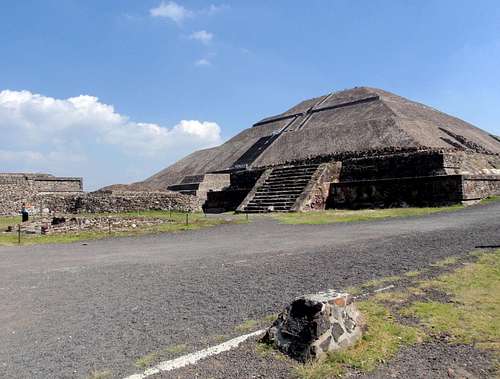
Pyramid of the Sun - 2341 meters - 7682 feet
There was only one day left in Mexico before our scheduled return flight. We unanimously agreed to stop playing alpinista and make the conversion to tourista. The next day we went to the city of Teotihuacán to visit the ancient ruins. We climbed the stairs to the top of the
Pyramid of the Sun (third largest in the world). Mike and Robbin had their first summit of the trip. At least we were all together here.
Final Thoughts
Turns out I learned some things from this trip.
Number one, detailed descriptive information for the routes on Mexican Volcanoes is difficult to acquire.
Number two, I should try harder next time to find detailed descriptive information on unfamiliar routes. Try to memorize the route before getting there.
Number three, the Mexican transportation system is pretty good, so long as you have a friend who speaks Spanish.
Number four, Mexican tacos in Amecameca are REALLY good.
Number five, the different colored rocks and formations on the Iztaccihuatl make "The Ridge of the Sun" the most awesome route I have ever seen. I will go back to finish it someday.
Mike's Trip Report
For a better account of detail and many more photos than are shown here, check out
Mike's Trip Report.


Comments
Post a Comment