
|
|
Mountain/Rock |
|---|---|
|
|
36.31209°N / 118.44719°W |
|
|
Tulare |
|
|
Spring, Summer, Fall |
|
|
10892 ft / 3320 m |
|
|
Overview
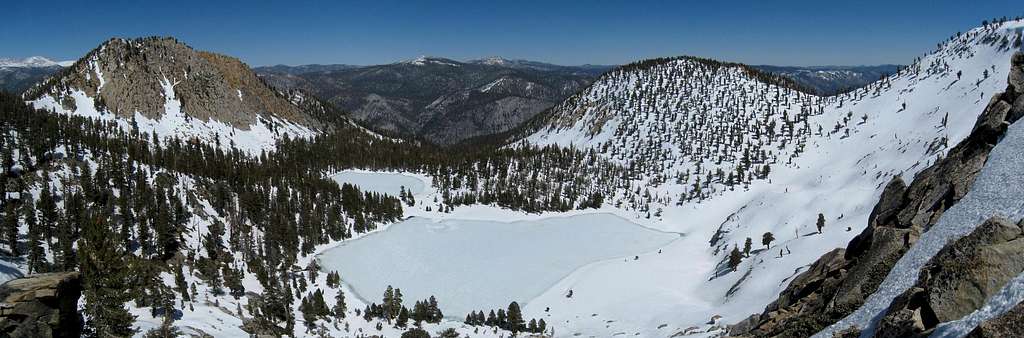
The Coyote Peaks are located on the southern border of Sequoia National Park along the boundary with the Golden Trout Wilderness in Sequoia National Forest. Reaching the summit is not technically challenging, with mostly class 1 and some cross-country travel. The routes are quite long and strenuous, however, demanding a minimum of nearly 30 miles and 9,000 feet of elevation gain round-trip. The trailheads are remote as well, and travel to each entails long, winding drives deep into the Sierra. Those that make the trip are rewarded with miles of secluded hiking through forests dotted with stands of giant sequoias, lush meadows, and extensive vistas from the summit. Coyote Peaks' position on the Great Western Divide provides excellent views northwest to Mineral King, northeast to Kern Canyon and Mount Whitney, and south to many of the lower peaks of the Southern Sierra.Due to their remote location and inclusion on the Sierra Peaks Section SPS List, Coyote Peaks are frequently climbed with nearby Angora Mountain 3.5 miles to the south.

Getting There
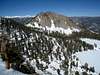
 Meadow Near Deep Creek
 Route Map
The three most popular trailhead options are the Jerkey Meadow and Lewis Camp Trailheads from the south in Sequoia National Forest and Mineral King via Farewell Gap from Sequoia National Park to the north. All options include slow, winding, paved travel to the final destination.
Jerkey Meadow Trailhead (36.16714° N, 118.48564° W)
From the north take exit 65A from Highway 99 in Earlimart to follow County Road J22/Sierra Avenue/Avenue 56 east. Continue straight for 40 miles, followed by a left turn on M-504/Parker Pass Road. After 12 miles pass straight through a four-way stop, and turn left after another 6.5 miles onto 22S82. Follow 22S82 20 miles to the trailhead at the end of the road. From the south follow Sierra Way/M-99 from Kernville 24 miles north to the intersection with 22S82, and turn right to follow it 20 miles to the trailhead.
Lewis Camp Trailhead (36.18164° N, 118.51534° W)
From the north take exit 76 from Highway 99 in Tipton to follow Highway 190 east. After 56 miles where Highway 190 becomes M-90, take a left turn onto 21S50. Follow for 4.6 miles and take a right onto 20S79 and follow signs a short distance to the trailhead. If coming from Kernville in the south follow Sierra Way/M-99 31 miles north an intersection with M-90, and turn right. Follow M-90 for 15.4 miles and turn right again onto 21S50 at the junction with Highway 190.
Mineral King (36.45277° N, 118.59583° W)
In Visalia exit Highway 99 and head east on Highway 198 toward Sequoia National Park. After 39 miles turn right on Mineral King road shortly after the town of Three Rivers. Follow Mineral King road 23 miles to its end.
Routes
Routes to Coyote Peaks include mostly class 1 travel with a short but steep final class 2 ascent at the end. The eastern summit is the highpoint.| Route | Distance | Gain | Description |
|---|---|---|---|
| Jerkey Meadow Trailhead | 14.8 miles one-way | 7,000 feet +1900 feet on return | Jerkey Meadow is the lowest trailhead in elevation and is a good option if the others are still closed for the winter. From the parking area follow the trail past a couple of seasonal streams for less than ½ mile to a sign marking an unmaintained trail branching off to the right. Follow the unmaintained trail, which is eroded but otherwise in reasonable shape. After about 1000 feet elevation gain the top of a ridge is reached at a junction with the trail from Lewis Camp Trailhead. Turn right and descend to the Little Kern River, where a suspension bridge eliminates any stream crossing difficulties. After the stream crossing there is an option to continue on the trail, or travel cross-country utilizing occasional use trails through the woods to save mileage. Once back on the trail there is a faint intersection after the first Deep Creek crossing (noted on the route map). Follow Deep Creek for 3 miles until a stream from upper Angora Mountain crosses the trail. To head directly for Coyote Peaks continue on the trail to the summit ridge, or if taking a side trip to Angora Mountain follow this stream cross-country towards Angora’s summit, keeping initially to the north but primarily to the south side of the stream. Once on the ridge there is alternating trail and cross-country travel the remaining distance to Coyote Peaks. |
| Lewis Camp Trailhead | 15.2 miles one-way | 5,900 feet +2,700 feet on return | The Lewis Camp Trailhead is the quickest of the southern trailheads to drive to from the north, and a good alternative to Jerkey Meadow. Follow the trail along the ridge 2 miles and 800 vertical feet down to the junction with the unmaintained trail from the Jerkey Meadow Trailhead. From here, follow the route above to Coyote Peaks. |
| Mineral King via Farewell Gap | 17.4 miles one-way | 7,100 feet +4,000 on return | The hike from Mineral King is very straightforward and has been used by several parties, sometimes as a through hike to one of the other trailheads. From Mineral King ascend 3,000 feet in 5 miles to Farewell Gap and the national park boundary. The trail drops and then contours along the Western Divide until climbing again to reach Coyote Pass 8 miles from Farewell Gap. After another descent and climb, leave the trail and follow steep class 2 terrain up a short distance to the eastern summit. |
| From Angora Mountain Summit | 4.1 miles one-way | 2,000 feet +1,300 on return | If climbing Angora Mountain with Coyote Peaks, the two are connected via a cross-country and trail route on the north/south ridge between them. The ridge rolls up and down, but vegetation is thin and travel is not very demanding. |
Red Tape
Entrance Fees:There are no fees if starting from the Jerkey Meadow or Lewis Camp Trailheads in Sequoia National Forest. The Mineral King Trailhead lies in Sequoia National Park, however, and an entrance fee is required. The Sequoia and Kings Canyon fee page has full details.
Wilderness Permits:
No permits are required for day trips but overnight trips require one throughout the year. There are no quotas for any of the three major trailheads. Permits for trips starting at the Jerkey Meadow or Lewis Camp Trailheads can be obtained from Sequoia National Forest in person, by mail, or by fax. See the Sequoia National Forest permit page for full details. Overnight trips starting from Mineral King require permits from Sequoia National Park. Permits must be obtained in person at the Mineral King Ranger Station during open hours from late May through late September, and are self-issued for the remainder of the year. The Sequoia and Kings Canyon permit page has complete details.
Food Storage:
Bear canisters are not required, but proper food storage is important. In May 2010 I saw a bear foraging for food near Deep Creek at 6500 feet.
Campfires:
Fires are not permitted in Mineral King Valley in Sequoia National Park. There are no restrictions in Sequoia National Forest.
| Western Divide Ranger District Office (Sierra NF) 32588 Highway 190 Springville, CA 93265 (559) 539-2607 | Sequoia & Kings Canyon National Parks Office 47050 Generals Highway Three Rivers, California 93271 (559) 565-3341 |

Current Conditions
Current NOAA / National Weather Service ForecastWhen to Climb
None of the trailheads are plowed in the winter, consequently spring through fall are the most realistic times for a visit. Summer months bring heat to the lower elevations. In early season snow is present along the ridge from Angora Mountain to Coyote Peaks and north of Farewell Gap, but those familiar with snow conditions should not have any difficulties.
 |
 |
 |
 |
 |
 |
Camping
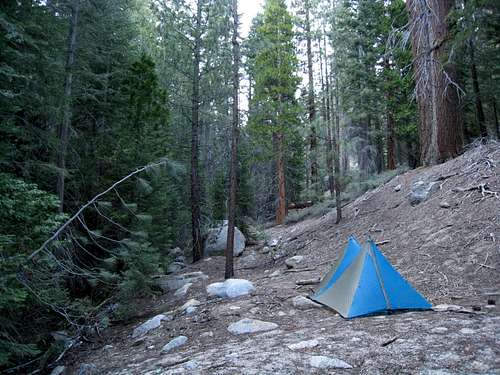 Camp Next to Deep Creek
In Sequoia National Forest roadside camping is possible at the trailheads, and the Jerkey Meadow trailhead even includes a few fire rings with pullouts. Dispersed camping is also an option throughout the national forest, or you can choose from one of over 50 developed campgrounds, several of which are nearby or en route to the trailheads. The Sequoia National Forest Campgrounds Page has more information.
In Sequoia National Park, options in Mineral King are limited to Cold Springs and Atwell Mill, both first-come, first served and with full amenities (vault toilets). Roadside camping is not permitted.
Backcountry camping is possible at numerous locations, including along Deep Creek and at the Little Kern River crossing to the south, any of the many creeks crossed approaching from the north, or at Coyote Lakes just below the summit.
Etymology
“The mountain coyote (Canis latrans lestis) has a wide range throughout the Sierra. (Grinnell and Storer: Animal Life in the Yosemite, 1924, pp. 71-76.)” – Francis P. Farquhar, Place Names of the High Sierra (1926)“From Spanish coyote, from Aztec coyotl; an extremely popular place name. Many geographic features in California were name directly or indirectly after Canis latrans, including a pass, a ridge, an Indian reservation, a land grant, and several settlements.” – Erwin Gudde, William Bright, California Place Names (2004)

bobpickering - Jun 8, 2018 2:48 pm - Hasn't voted
Lion FireIn 2017, the Lion Fire burned a large chunk of the Golden Trout Wilderness, including the usual approach to Coyote Peaks and Angora Mountain via Deep Creek. The forest is burned from about 6,000’ to about 9,500’ on the way to Coyote Peaks. The burn reaches almost to the summit of Angora Mountain. As of June 2018, the area was incredibly ugly, but travel wasn’t too difficult. If dead trees fall, and the USFS doesn’t remove them, travel could get very difficult.