The Beginning of an Adventure
It all started in April, when my brother and I were visiting what would be one of the least recognized mountains within the Appalachians, if it were not a state highpoint; Cheaha Mountain. In April I completed 7 southern state highpoints, while on a business trip to Memphis and my brother had joined me on a couple of these mountains. While climbing that highest peak in Alabama we chatted about other trips we would like to do in the future. Many crossed our minds, but one mountain seemed to steal attention from all others, due to its proximity in the east and its fame as one of the roughest, most isolated peaks in the eastern United States. We wanted to climb the Beast of the East, the mile-high mountain, the northern terminus of the Appalachian Trail, the Knife Edge; we were desiring to climb Mt Katahdin. This mountain had always been a possibility for us, but it just seemed too far away and with other mountains (Adirondacks, White Mountains, Green Mountains, etc.) much closer, we never gave it much thought. As I usually do, I joked about taking a trip to central Maine to climb Katahdin, but my brother responded in a serious tone. He had apparently given it some thought and was willing to make the sacrifice to get to Maine. It took me very little time to start thinking of it as a real possibility. Many obstacles stood in our way and much planning had to be done, but we wanted to see this mass of rock and climb its ancient slopes too much to let anything stand in our way. It became not only a possibility, but a date set on our calendars.
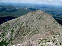
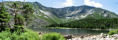
![Panorama of Katahdin and Hamlin Peak]() Katahdin Massif Panorama from Pamola Peak
Katahdin Massif Panorama from Pamola PeakGetting to Vacationland
Over the next couple of months I began to get things arranged. Since neither of us wanted to put the miles on our old, worn down vehicles, I arranged a rental. I also called Baxter State Park to try to find a campsite for our visit. Since we were planning on going the weekend of July 4, I knew that planning far in advance would be a good idea. After a little hassle trying to find a site in a location close to the mountain, I was able to get a lean-to site at Abol campground, on the western edge of the mountain. As the month of June slowly faded away and the time grew closer, I made an abrupt mistake.
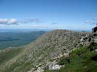
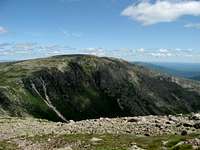
![Baxter Peak]() Terrain of Baxter Peak
Terrain of Baxter Peak I had jokingly asked my father if he wanted to come with us on the trip. Little did I know that he began to seriously consider it and eventually talked about it with my brother. Although it was a mistake on my part to even plant the seed into his mind regarding the trip, it turned out to be a fantastic trip with him. He has slowed down and lost some of his visionary attitude in his older age, but he still has a heart and mind to be young and to try to accomplish challenges. So, a third leg was added to our adventure.
Time rapidly drifted by and eventually it was time to meet my partners in northern Pennsylvania. I left early from work on a Wednesday afternoon and made the four hour drive to Mansfield, PA to pick up the rental and meet my brother and father. From there we drove to Elmira, NY to visit some family and get a little closer to the borders of Maine. We had trouble fitting all we wanted in the rental car, due to our overstuffed cooler and food bin, and due to the amount of gear we were taking for just a 4 day trip. Eventually, with some maneuvering of gear and loading up the backseat, we fit it all. However, the person in the backseat always had to be weary of the large pile of stuff that could periodically topple into their open space. After a night of catching up with family we headed to bed at an early hour to get a fresh and early start the next morning. When the next morning came, we were on the road by 6:30. We had roughly 11 hours to drive, up across upstate New York, the full length of the state of Massachusetts, across a few miles of New Hampshire, and then finally into Maine. However, once within the borders of Maine does not mean that the destination of Baxter State Park is near. It seemed that nearly half of the driving occurred in the state.
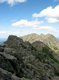
![Pamola Peak and the Knife Edge]() The Knife Edge
The Knife Edge We made time on the highway and only made a few stops along the way, one for a cup of coffee in Owego, NY and a few other stops for gas and bathroom breaks. Along the way, license plates of certain cars declared their state ‘Vacationland,’ christening their state the best vacations that could be offered. And it is hard to argue with such a claim, since alpine mountains, rocky beaches, an infinite amount of lakes, gargantuan rivers, hip cities, and vast wilderness adorn the state of Maine throughout. I am sure it is Vacationland for many up and down the eastern seaboard.
As our overstuffed rental car neared the town of Millinocket, we kept wondering, ‘Shouldn’t we be able to see the mountain by now?’ It was about dinner time, but there was a dull haze that stood over the land. As we peered ever harder into the foggy distance, we noticed, high above the standing trees, an almost imperceptible ridgeline on the mountain that wasn’t covered by clouds. We suddenly realized that the entire massif of Katahdin and its neighbors was covered in a dense fog and haze of clouds that looked much like the empty and dull sky surrounding it. We never even saw the mountain, except for that faint glow of a ridgeline while driving toward the State Park. Yet that was enough to begin to unleash our respect for wilderness places and our love for the mountains.
Baxter State Park
Once inside the park, we began trekking up toward the Abol Campground to make our stake for the night. As we crossed past a swamp land we all noticed a large brown object standing out in the swamp. We knew immediately what it was. A moose was having dinner, munching on the soft plants, while knee deep in water. We ran down the bank to the edge of the water to get a better look at the moose. We were still about 150 yards away, so we were not acting foolishly, but we wanted to get a view away from the trees and dust of the road of this monstrous animal. He was surely a grand site to see upon our entrance into the park. But we were tired, hungry, and getting eaten by bugs, so we hopped back into the car and drove the last few miles to the campground. At the ranger hut, we signed in and looked around at the various display of information about the park and the mountain they had. Sitting on a picnic table on the porch of the hut was a miniature, three-dimensional diagram of the Katahdin massif with all trail, lakes, peaks, and other noteworthy features listed on the diagram. It was fascinating to stand there, looking at the display, and trying to picture the route we were about to embark upon over the mountain.
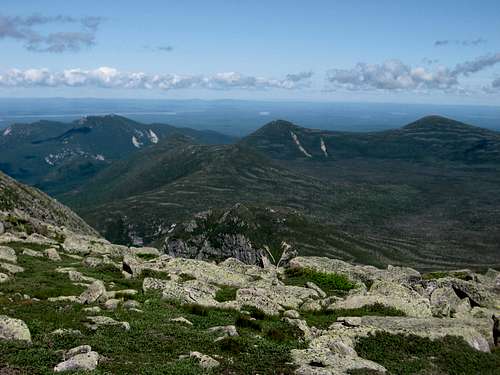
![A Plethora of Peaks]() Baxter State Park Mountains
Baxter State Park Mountains
Our plan was as follows: we would start out at the campground the next morning and begin climbing the Abol Trail up toward the Hunt Trail on the plateau. From there we would use the Baxter Peak Cut-Off trail to bypass the peak and make our way to the opposite side of the mountain. Once we met up with the Saddle Trail, my brother and I would continue down the backside of the mountain, while our father would head up the Saddle Trail to Baxter Peak. Since my brother and I had always wanted to do the Knife Edge, we had to climb back down the opposite side of the mountain in order to make the Knife Edge traverse, while our father waited for us at the top, knowing he could never make the extra miles. So, the two of us would head across the Cathedral Cut-Off Trail to link up with the Cathedral Trail and head down it. At Chimney Pond, we would head up the Dudley Trail to the top of Pamola Peak and then across the great Knife Edge to the top of Baxter Peak. Once at the top, we would meet back up with our father and begin heading down the Hunt (or Appalachian) Trail. Once back at the junction where the Abol Trail comes in, we had decided to continue down the Hunt Trail since we were told that is was not nearly as steep, even though it was 1 mile longer of a descent and would require us to find a ride from Katahdin Stream Campground back to Abol Campground.
While at the ranger station, we talked to the ranger for a bit, and I purchased a map, since the only one I had was the map of the Appalachian Trail through Maine, and it didn’t give the greatest detail. The new map was just of the Katahdin massif, but I assumed that was all we needed since we had only planned to spend time on the mountain. After talking with the ranger a bit, we learned that it was probably best to carry around three liters of water. I had originally planned to only carry two liters, but it turned out best that I had three while climbing around the mountain. After we left the ranger station we preceded to our lean-to; a three-sided structure with a roof to keep out the rain and a floor to keep the sleeping bag off the ground. We tried to put one of our backpacking tents in the lean-to, so we could keep the bugs out while we slept, but it was too large. The tent only had enough room for two people and it took up the entire space of the lean-to. However, we were three people and we would not be able to all fit in the lean-to if the tent was in there. So, we threw the tent back into the car after a few futile attempts to make it fit and began to make dinner. After eating and sitting around the campfire for a little while, we finally rolled into bed, with only the dark sky and the ticking clock keeping us from the top of Katahdin.
The Ascent
The morning of our climb had finally dawned. My father awoke before my brother and I and he shook us around 6:00am. We had gotten prepared the night before, so we were virtually ready to go, except for putting a few calories into our system to propel us up the mountain. We ate breakfast, signed in at the ranger station, and were ready to go shortly after 6:30. We wanted an early start, since we knew that we had many miles and many boulders to climb. Then, we began the trek. We started up the Abol Trail at the far end of our campground and it began at a moderate grade through a mixed wood forest. Over the course of the first mile we kept getting miniscule glances at the ridgelines running along the mountain, but nothing substantial. We still had not gotten a good look at the mountain or anything it had to offer, since it had been obscured in fog on the way into the park.
![Abol Slide]() Looking Westward from Abol Slide
Looking Westward from Abol Slide The day was bright and brilliant, with hardly a cloud in the sky, so we didn’t have to worry about it being obscured in clouds. But we did have to wait until we got away from the trees. As we neared Abol Slide we suddenly came to an open area within the trees and looked straight up the ridgeline we were about to climb. Rock was littered everywhere on the mountain. Yet the top of the mountain was still obscured behind the massive wall in front of us. At the top of this ridge was the ‘tableland’ or ‘plateau’ region of the mountain; a vast, open, and flat area that stretched to the north and west of the highest peak of the massif, Baxter Peak. Included in this large ‘tableland’ was the second highest mountain in the state of Maine; Hamlin Peak. Yet, we had many boulders to climb before we reached this section. The trail steepened as we made our way up and we soon began to have to pull ourselves up and over the many rock faces that obstructed our path. Looking behind us became an awesome sight as well. To the south the land was flat and stretched forever, littered with lakes, ponds, and rivers. To the west and northwest the land had a large valley with a few lakes, but in the distance were more mountains. The sky was a deep blue and the viewing terrific for such a mid-summer day. I had only wished that I knew the mountains of Maine better, so that I could identify the many peaks and ridges that were off in the distance. Yet, I knew nothing of these mountains to the west, which most assuredly the Appalachian Trail traversed somewhere.
We continued our ascent, obtaining a few cuts, scrapes, and bruises while climbing over the rugged terrain and all the while heading up. When we reached the Abol Slide, we just had to work even harder at going over the boulders that lay on the mountain. It was not much like hiking, but more like a kind of scrambling, that was needed to reach the ridge of the mountain.
![Nearing Thoreau Spring]() Near Thoreau Spring
Near Thoreau Spring My father continued to do well in his climbing over this section and only had trouble in a few areas of hoisting himself over various boulders. Yet, before too long we had passed a younger couple from the Boston area and watched as a group of younger climbers came up from below. Then we arrived at the ridgeline and intersected the Appalachian Trail at Thoreau Spring.
Here we were on top of a huge plateau that stretched around the north and western sides of the mountain. The top was visible, merely a mile hike up the Appalachian Trail, but that was not our route. Since my brother and I had wanted to do the Knife Edge, we went forward on the Baxter Peak Cut-Off Trail which wrapped around the peak to the north so to proceed to the back side of the mountain. The beauty from the plateau was astounding. Peaks to the north shot up out of the valleys of lakes and rivers, which included such mountains as Doubletop Mountain, Turner Mountain, The Brothers, The Owl, Mt Coe, and Hamlin Peak. The feel of this area was like being in an open field, with boulders strewn all over and low bushes growing where they could. Flowers even dotted the tundra in this high terrain. As we made our way around the mountain, Hamlin Peak and some of the basins began to emerge into view on the eastern side of the mountain. Soon, we arrived at the junction with the Cathedral Cut-Off Trail and the Saddle Trail, our parting location from our father. We gave instructions to him one last time, telling him to wait on top of the mountain for us, as we descended and then re-ascended via the Knife Edge. We had no idea how long this would take, but it was our goal. Then we split ways.
Re-climbing the Mountain
![1st Cathedral]() 1st Cathedral and Baxter Peak
1st Cathedral and Baxter Peak
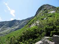
The short Cathedral Cut-Off Trail wound around the mountain through a lifeless boulder field that did not even have grasses growing around the rocks. As the trail neared its end at the Cathedral Trail, the Knife’s Edge finally came into view. Pamola Peak, Chimney Peak, and the rest of the ridgeline was in sight, the first time I had ever looked on it with my own eyes. It looked incredible, but what looked even better was the sheer size of the mountain. I had never seen a mountain like this in the eastern United States. The massive expanse of rock that formed the mountain, along with the large bowl shaped basin that conformed down around Chimney Pond was simply amazing. We could look down the Cathedrals and only see the one closest to us, since the terrain was so steep. Looking to our right we could see the top of the mountain where the Cathedral Trail lead. If we glanced behind us, Hamlin Peak stood, with its green slopes and gentle summit. And it was amazing to notice the lack of any plant life on the precipitous columns of rock. Trees stopped growing only a short ways up the mountain and grasses were hardly distinguishable on the upper slopes of the mountain. It some ways, it appeared that we had suddenly stepped into Colorado.
After trying to take the entire scene in, we began to descend via the Cathedral Trail. The map I had bought, which gave a description about each trail on the mountain, recommended not descending the Cathedral Trail, due to its steep terrain. But we decided to do it anyway, being the most direct route down to Chimney Pond. As we started, one boy-scout after another passed us on their way toward the top. As we descended, we first came to the 3rd Cathedral, with the 1st Cathedral near the bottom of the trail. The Cathedrals were large rocks the seemed to protrude out of the mountain and create a piece of terrain that jutted up instead of following the steep ridge downward. And with each Cathedral that we came to, we got a different view of the mountain.
![3rd Cathedral and Baxter Peak]() 3rd Cathedral and Baxter Peak
3rd Cathedral and Baxter Peak My brother was taking this part much faster than I. He would scramble down a ways and then turn and wait for me, taking a few pictures of the mountain as I clambered after him. After the last Cathedral, which was 1st Cathedral, it seemed we should be getting close to Chimney Pond, but looking down was no relief. Boulder fields seemed to stretch for miles down, even though we had made it over halfway. And with each step our legs and knees were starting to get weary and sore from the hard downhill descent. We would take rests, but always knowing that our father was at the top of the mountain waiting for us kept us going at a good pace. So we continued downward. The scrambling over boulders and occasionally sliding down on our rear ends became quite obnoxious. It seemed to take forever to get under the tree line and to a place where we could pick up the pace on more level and less rough ground.
Chimney Pond was a brilliant blue that shone out of the green of the trees that surrounded it. As we peered at the ridge that the Dudley Trail traversed, we realized what a day we were in for. The ridge of Pamola Peak seemed to reach forever into the sky, upward toward the top of the ridge, and we knew we had to ascend it. But after continuing our battle through the boulder field, we finally arrived under tree line and on some more level ground. But before we could enjoy the level, less rocky ground, we arrived at the Chimney Pond Office. We had finally made our first descent of the mountain. After a brief conversation with the ranger at the office, regarding snow that was 6 feet deep in mid-April at Chimney Pond, I headed down to the lake. The lake shone with the mid-summer sun and the mountain hugged itself around the lake, seeming to comfort it. The beauty was astounding. I had never thought that the East could have a mountain that looked quite like Katahdin. Bare and rocky, with masses of exposed rock gleaming in the early afternoon sun, it stood tall. Some green began to show on the lower half of the mountain, with trees encircling the lake we were standing at. To our right stood the Cathedral ridge we had just made our way down and to our left was the Dudley Trail and the ridge that led to the Knife Edge. We took in the great masterpiece in front of us and then began the next traverse.
We started up the Dudley Trail quickly, knowing we had much left to do, but with patience, knowing it would take a while to get up this ridge. The rocks were massive and it seemed as if we had to pull ourselves over rock after rock, frequently using knees, hands, and bottoms. We started in trees on the way up, but within a short while were above the tree line and able to look at the rugged country around us. In front was the ridge we had to climb with the South Basin far down below on our right. On the other side of the South Basin was the Cathedral Ridge and beyond that Hamlin Ridge and Hamlin Peak. Behind us, which was northward, were many other mountains that quickly faded to a more gentle terrain, especially to the northeast. While climbing this section of the mountain we passed a couple, who did not look prepared to be climbing the mountain, wearing jeans and complaining about years of bad smoking habits. We talked to them for a minute and then quickly passed them and came upon index rock. Index rock is a large, protruding rock that seems to point toward the sky like an index finger. We discussed whether one could climb up to the top of the rock. What had seemed so far to the top of the mountain now was passing under our feet in our scramble toward the top. And suddenly we were standing atop Pamola Peak, a sub-peak of the Katahdin massif, and the beginning of the Knife Edge.
![Katahdin Panorama]() Chimney Pond Panorama
Chimney Pond Panorama
A few others crowded around this small summit with us and we chatted with them about the mountain. A pack of boyscouts, the ones we had passed on Cathedral ridge earlier, were now just finishing their trek across the Knife Edge. We said hello to them, again, as their leaders declared their praise on our 2nd climb of the mountain. But our minds were still set on the task ahead. Some around us gave us warnings of the coming ridge, explaining that they would never want to tread across that rock again. Yet we were prepared, though a bit nervous. As we began to climb down the first ledges of Pamola Peak, we suddenly knew that this was not going to be an easy trek. We had to half slide, half jump down an almost vertical rock face onto another narrow ledge of rock, all the while the only flattish ground below was near 3 to 4 body lengths below. But with care and slowness of movement we made it to the small chute between Pamola Peak and Chimney Peak, the next small peak in a series of small peaks across the Knife Edge.
![Pamola Peak]() Pamola Peak
Pamola Peak
Now we had to ascend Chimney Peak, clutching the vertical rock and small tufts of grass that hung dearly onto the sides of the massive walls. Slow movements were needed, but we had both been to places that required care like this before. My brother lived for over a year in Colorado, climbing some of its majestic peaks and crossing terrain he never thought he could cross. I had spent a month on the Long Trail in Vermont and had crossed some of the more treacherous sections in awful climates. Rain, wind, and cold seemed to hit when the footings were the most awful. Now, on this behemoth of a mountain, we had perfect weather and solid, though vertical, footing. We grabbed the rock and finagled our way up the giant slabs until we stood atop Chimney Peak. From here, the main peaks of Katahdin, South and Baxter, seemed far away, as if days would be required to cross the territory in front of us. A well-worn herd path could be seen along this ridge in front of us, extending all the way up South peak. Even on the hard and resistant rock could be seen the evidence of a multitude of people who had traversed this section before; they had left behind an evident path. But the day was beginning to wear on and the afternoon was growing shorter with each minute. We knew we had to be quick, especially with our father waiting for us at the top. We continued onward, seeming to cross the ridge quite quickly, but with very intentional movements. At times the small breeze from the east seemed to push our bodies toward the edge and a little nervous feeling would build inside. At other times, even when sure of the width of the ridge, I would crouch or slide along the rock, trying to hover as close to the solid ground and lower, as much as possible, the center of gravity.
![The Knife Edge]() Jagged Peaks on the Knife Edge
Jagged Peaks on the Knife Edge Never did we feel as if danger was sure at hand, nor were we afraid of tumbling over the edge and down the precipitous slopes; we just knew that care was needed to keep far from that possibility. We worked toward South Peak in a rhythm; my brother would work ahead and I would follow shortly behind. When he needed a rest, he would stop, wait for me to catch up, and then he would start again while I was resting. This was the way we slowly made it toward the top, after our already exhausting day.
Before too long, we were crossing boulders that only seemed to get larger, as we approached South Peak. While glaring at the top of Baxter Peak, we could see the outline of a human, standing next to the large cairn at top, and our conclusion was that it was our father. The synthetic hoodie that he wore, which inevitably made him look like a seasoned monk, was unmistakable, even from the far distance we were at. From the top of South Peak, it was a quick jaunt over to Baxter Peak and to where our father was waiting. The jaunt consisted of crossing enormous boulders and taking extreme caution not to step between them and turn ankles. As we made it to the top we passed 2 couples who were apparently hiking together and who were not doing well. They were resting near the top of Baxter Peak, but still pushing onward. Even for us younger guys, we were worried about making it down the mountain before dark; but with the older people up there and still working there way to the top and not appearing as if they were doing well, we were a little worried. Once to the top of the mountain I gave my father a hug, since we had somewhat assumed that he would have taken off on us by this time, but he had still waited for us. He told us that he had become the interim summit caretaker for the day, talking to people who visited the summit and took photos of people as he waited for nearly 4 hours up there for my brother and I. Also, at the top when we arrived were 4 younger kids, probably in there mid-teens, who were waiting for the older folks a little ways down from the top. Yet, we didn’t want to wait too long at the top, so we snapped a couple photos and took off down the Hunt Trail toward Katahdin Stream Campground, which was over 5 miles down the south western arm of the mountain.
The Final Descent
The first mile and a half down was fairly easy, since it was across the great tableland again, and pretty even terrain. The only thing that slowed us at this point were the boulders strewn everywhere and the exhaustion which was starting to set in. We jockeyed for position with the younger kids, as they began making their way down the mountain a few minutes after us. We crossed the Abol Trail on our way down, but since we were told that the Hunt Trail was much gentler, even though it was near a mile longer, we decided to take the Hunt Trail down. The Hunt Trail is also the very last piece of the Appalachian Trail as it ends at the top of Katahdin. I was quite excited to do the reverse of what so many people have their eyes set on from northern parts of Georgia. As we got near the Gateway, the last part of the tableland, before it begins to steeply descend the mountain, we realized our dire need for water. We each had only a few mouthfuls of water left, even though we had each packed 3 liters, and we had nearly 5 miles left.
![Flora of Katahdin]() Flowers on the Tableland
Flowers on the Tableland Our mouths were beginning to get parched thinking about it, but there was very little we could do, but continue on and hope that we could get down before nightfall. As we began down the large boulder field, I wondered if we had not made a bad decision in going down this particular route. The boulder field seemed to stretch forever down this ridge and the only thing that kept my spirits up was that I assumed that the trail must deviate from the ridge and begin to head down through the forest. Yet, as we continued to descend, extreme exhaustion set in. The lack of water, the long day we had already done, the miles of rugged terrain we had already crossed, all began to set in as we continued down this ridge. My brother and father started going down at a faster pace than I. My father especially, seemed to find a second wind after waiting at the top of the mountain for that long time.
We continued onward and ended up climbing a bit of the ridge with the younger kids that we had first met at the top of the peak. As we made our way down, we could glance up and see the older couple just starting their first attempts at some of the boulders. It had taken us quite a while to get down thus far and we feared that it would be extremely dark by the time they made it down. The ridge in front of us, however, seemed to stretch forever down the mountain. In places it seemed impossible to continue, but we always found a way. At other places, where it would have been impossible to cross the terrain, were placed a few metal handholds or a ladder to assist with the climb. On and on the boulder field went, and the farther it went, the more tired and sore the three of us become. We were incredibly thirsty and by this time it was after dinner time. The sun was getting lower and lower in front of us and added to the quickening dehydration. My only hope was to get to tree line because there, I assumed, would be easier terrain, with less boulders to cross. But once we under the cover of trees, I suddenly realized how wrong I was. Huge slabs of rock still required incredible care as we descended through the pine scented forest. I imagined how difficult this must be to traverse in the opposite direction, after spending months on the trail, and carrying a larger pack then we had. How difficult it must be to finish atop the most rugged mountain in the East. For this was the conclusion I came to while on the mountain; I knew of no mountain in the Eastern United States that came close to the difficult terrain and the intricate care that was needed while treading its treacherous slopes.
As we approached Katahdin Falls, fatigue set in for everyone. My father began to get incredibly irritable and would hardly move a step without complaining.
![Top of the Cathedral Trail]() Beginning the First Descent
Beginning the First Descent I felt pain and soreness like I had seldom knew before in the lower extremities and an almost lightheadedness from the lack of water over the last few hours. My brother kept his cool better than everyone else, but the overtiredness from the day could still be seen in his face and movements. He too was getting a little ill-tempered. It became incredibly hard to deal with my father. We offered him a stick to help take some of the weight off his legs; he refused. We had to wait after nearly every step until he would catch up, since he was taking painstakingly slow steps on his way down. We tried to have patience for him, knowing that he was much older than us, but frustration began to show. Little snaps of anger would bubble from our hearts through our mouths toward one another, near to the point of hatred. Yet, we had to find patience. By the time we reached Katahdin Stream Falls, the sun was setting on the skyline ahead of us. We got a glance in an opening in the trees and could see the orange, red, and purple sky lighting up along the horizon, signaling the end of daylight.
We continued to trek through the forest, as the trail wound on toward the end. The high school kids had long since passed us and were probably near the trailhead, while their parents were somewhere far behind us, probably in as bad shape as our father. Yet, we all were feeling fatigued and were irritable. We crossed Katahdin Stream on a wooden bridge, which signaled only one mile left to the Katahdin Stream Campground. However, from there it was a two mile walk along the road to our campsite at Abol Campground. Yet, we were hoping that we could find someone to give us a ride back to our site, so that we would not have to trudge the two miles in the dark along the road. The last mile seemed to stretch on forever, as it wound along Katahdin Stream. Daylight under the canopy of trees was virtually snuffed out and fear of spraining ankles or tripping over rocks and roots snuck into our mind. Therefore, our speed got even slower, as we precariously stepped over rock and worked our way down.
The Aftermath
![Balancing on the Edge]() Crossing the Knife Edge
Crossing the Knife EdgeBefore too long we arrived at the campground, feeling weary from the trail and tense from the heightened emotions between us. We began to walk pass the parking lot for the trailhead and down into the campground hoping to find someone we could ask for a ride. Our campground was another two miles further up the road and we did not want to have to walk those last miles in the dark after such a day. As we proceeded into the campground we saw the high school age kids at their campground, with lighted lanterns and a fire already going. We knew they had beaten us in the last miles, but their parents were still somewhere on the mountain. We hoped for their safety but ours was also a concern, since we had run out of water on the final descent. We finally arrived in an open field in the middle of the campground and located a man, probably around my brothers’ age, who was waiting outside the restroom. My brother and I quickly proceeded toward him to ask for a lift. As we proceeded, we could tell that he was getting nervous as we neared. My brother quickly told him our dilemma, with our father who was in a tough condition, and our lack of water. He told us he needed to consult with his girlfriend, who had come with him to the mountains for a few days. After consulting with her, he decided he could give us a lift, which was a great relief in our time of discomfort. As he left to retrieve his car, my father and I lounged in the cool, soft grass of the field, knowing that it would be a rough evening and following day, with the soreness continuing to linger even when taking pressure off the area. As I sat I also noticed that my fingers had been rubbed raw from the constant grasping of the coarse stone on the mountain. They seemed to be more sensitive than normal and were quite painful to apply pressure to. After about five minutes of waiting, two headlights advanced on us from the campground road and came to a rest before us. We jammed all our gear into the man’s car and hopped in. It was finally over with. We had finished our ridiculous traverse of the mountain, though a little worn and weary from the travel. We made conversation with our driver as best we could, but were more focused on getting a good meal and heading to bed than anything else.
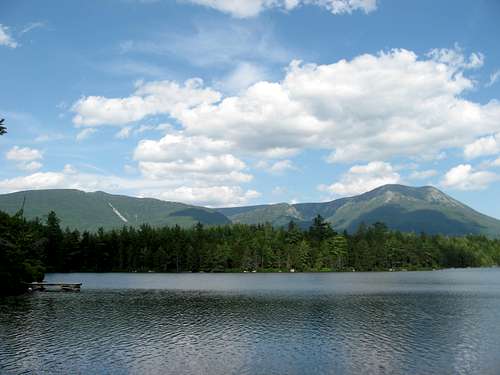
![Katahdin from Daicey Pond]() Daicey Pond and Katahdin
Daicey Pond and Katahdin
After we had been dropped off at our campsite, I felt like skipping any kind of eating and heading straight for my sleeping bag. Yet, my brother and father persuaded me to get some food into my body after the long day and wanted a little help in getting things around as well. So, we started a fire, gathered and drank much water, and cooked some hot food to nourish us. I didn’t feel much like eating, but forced as much down as I could, knowing that would make speedy the recovery. Movements came very slow to us all as we made our way around and prepared our dinner. We had spent well over 12 hours on the mountain. We had started at 6:30 in the morning and by the time we got back to our campground it was after 9 in the evening. It was an incredibly long day and now I was ready to make an end to it. After helping clean up from the mess we had made, I jumped into my sleeping bag. It took a little while longer than I had wanted to fall asleep since my body was so weary but sleep did come.
A New Angle of Katahdin
The night of sleep was somewhat restless since my body was so sore, that I woke with nearly every turn in the night. Yet, I was able to sleep in to a late hour, which for me is usually 8 in the morning. We rested around the campsite throughout the morning, eating a good breakfast and trying to relax after the arduous climb the day before. Later in the morning we drove into Millinocket to pick up some food supplies and to check out what the town had to offer. We didn’t find much, so we headed back into the park to explore some new areas.
![Evening Shot of Katahdin]() Katahdin in the Dusk
Katahdin in the Dusk We decided to check out the Daicey Pond area. When we arrived at Daicey Pond we were awed at the incredibly angle that it gave of Mt. Katahdin and the glory of another beautiful day. We stared at the mountain from a dock, which was near a small lodge on the northern edge of the lake. In front of us stood the Hunt Trail ridge, which is the ridge that the Appalachian Trail traverses. The mountain looked starkly different from this angle, than it did from the opposite side, at Chimney Pond. Here the mountain seemed robust, with a high, flat plateau on top, and simply popping up out of the lower terrain around it. From Chimney Pond, the mountain was much more rugged and was carved in various bowls and chutes.
As we stood around Daicey Pond we decided it would be best to stretch our legs on a short hike to work out the stiffness. We worked our way down the Daicey Pond Trail, which quickly came to a junction with the Appalachian Trail. We could proceed southward on the Appalachian Trail to where it bypassed Big and Little Niagara Falls or we could head northward and begin to circle Daicey Pond. We decided to do the short loop around Daicey Pond. As we continued around, views of Doubletop Mountain abounded. Doubletop is a unique mountain that juts steeply out of the ground and then has a high saddle that dips very little between its two summits. From Daicey we could only see one summit, but its steep terrain was incredible to set eyes upon. As we continued around the lake we slowly made our way around to the eastern side of the lake in which no mountains, except some low hills, were visible. We continued on the trail until we reached the small parking lot where we had left our car and chatted to a few friendly day hikers on the last quarter mile. As we made our way back to the campsite to eat dinner, we passed a small boggy area that opened up to a great viewing area of the mountain. We stopped to take a few pictures and take in the broad scenery before us, since we knew that in the morning we would be heading back on the highway, toward our normal lives.
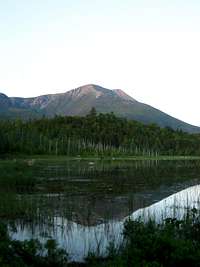
After we had eaten some dinner, we wanted to do a little more exploring around Baxter State Park, before the long daylight hours had expired. We decided to head north on the road that our campground was on, which headed toward Nesowadnehunk Field and the opposite side of Doubletop Mountain. As we got passed by the Katahdin Stream Campground we noticed a small bog through some trees on the western side of the road. We stopped the car and headed toward the bog, hoping to spot a moose out in this marsh. As we descended down the small hill to get to the marsh we noticed that here was another great viewing angle of Katahdin, in the fading daylight hours, while being reflected on the marshy water before us. It was quite a glorious sight. Yet, even though we saw some moose tracks in the mud, we didn’t stay long because the mosquitoes were obnoxious and the mud was deep. We continued to head north, up the road, and past Foster Field. Before we got Slide Dam, something large and dark colored was spotted just in the woods from the road.
![Hamlin Peak]() Hamlin Peak
Hamlin Peak A large yell of “MOOSE!” was heard throughout the car, as it came to a screeching halt. A large female moose stood just yards off the road, in the overgrowth and we stared at it in wonder at its awkward looking features. This was by far the closest I had ever been to a moose and now I saw it features in much greater detail. It was a grand creature of creation. As we sat there watching the moose a car full of high school or college age kids pulled up next to us and began to get out of their car, knocking out beer bottles, and trying to take pictures of the moose. We knew it was time to go. So, we continued up the road to Slide Dam. This was a neat area of a stream on the back side of Doubletop Mountain, where the water cascaded over a few smooth rocks. We got out of the car and walked around the stream for a few minutes and I looked up at the tall features of Doubletop Mountain, looming far above. Then we continued on another couple of miles to Nesowadnehunk Field, where we decided to turn around and head back toward our campsite for the night, since the hours of darkness were near at hand.
Heading Home
The only surprise the next morning was when we were on our way out of the park. As we drove down the park road, we rounded a bend and there in the middle of the road was a moose. As we slowed down before the moose it began to run down the road away from our car. We continued to follow the moose in our car and probably followed it nearly a mile down the road before it finally decided that the road was too exposed and took off into the woods. As it ran up the hillside away from the road we headed past and out of the park. The rest of our trip home consisted of visiting the highpoint of Rhode Island, Jerimoth Hill, and climbing the few miles of trail to the highpoint of Connecticut, Mt. Frissell. The views from Round Mountain, the next mountain to the east of Mt. Frissell, and the steepness of the terrain were surprising. I had not imagined it to be quite like it was and it was better than I thought. However, the day was the worst day we had on our trip, with a dull, overcast sky that choked out any excitement the sky could show. As we made our way home we drove through the Catskills and near some other northeast 115 high peaks. And by midnight of July 6 we were home, on a hill in the Allegheny Plateau, sleeping in our own beds. The trip was finished. All was done. Another milestone mountain had been conquered. The next time I desire to climb Mt. Katahdin is at the end of a 2,175 mile backpacking trip.


Comments
Post a Comment