
|
|
Mountain/Rock |
|---|---|
|
|
16.1898°S / 68.25804°W |
|
|
Hiking |
|
|
Winter |
|
|
17438 ft / 5315 m |
|
|
 The summit view.
Austria Peak is not very popular at Condoriri area. It is a great 5000 summit and perfect to acclimatize.
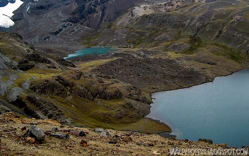
It has 5.315m and you don't have to overcome a great altitude difference to reach its summit, the base camp for that and other mountains is at Laguna Chiar Kota, a quite peacefull and gorgeous lagoon at 4.650m high, inside the valley of Condoriri.
The hiking is very easy. When I climbed that peak, it was late autumn and i got -7°C at the summit and it was quite windy that day, really bad weather.
It is a walk up to the summit and to impressive views to some unnamed 5000 peaks behind Austria itself and by the left wing of Condoriri Peak (5.648m) and its glacier, covered by hundreds of crevasses.
You wont need more then two and a half hours to get there from Laguna Chiar Kota.
Getting There
To get there you must be at La Paz, Bolivia's capital and bigger city. Find yourself a transport to take you to the small (really tiny) vilage of Tuni (4.448 m), even taxis take you there, it's a long drive but they don't care. Bolivia is a poor, much por country, so everyone does anything for money to support the family. The price is gonna start at around BolP$ 400,00 but, negociate, the price is gonna drop to half the price, even less.Once you get to Tuni, follow the trailhead to Condoriri valley and try not to die of excitement looking at the valley itself, it is an amazing place. Several 5000 summits and the star of the place, Cabeza de Condor, is really something to behold for weeks. When I went there I was absolutly alone at Condoriri area, bad weather prevented others climbers from going. I didn't care much so it was a great experience, completly alone, not even villagers walking by.


Red Tape
For some climbing such as Tarija Peak or Aguja Negra Peak I would strongly recomend you to hire a guide, but for Austria you don't need it. Perfectly fine to do it by yourself and better with some friends by autumn. But if yu go at summer time, several snowstorms turn the place into a deadly trap. It is always better to prevent the accidents, not to solve them.Camping
You can camp anywhere you want, but the best place to camp is at Laguna Chiar Kota, 4.670m. There's ready spots with rocks to give some cover to your tent, bathrooms, and plenty of water.Services
Services:You can find food and mule services in Tuni village, and it is not expansive at all. Also guiding services for almost nothing can be found there.
Don't forget to sign the visitors book! (provided by the people at the village)
Weather Forecast
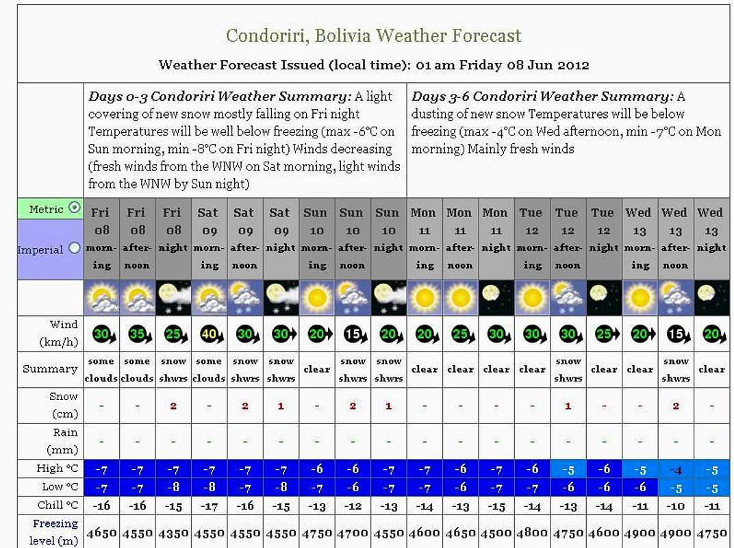
PS: The weather forecast on this link is not for this mountain but it will do just fine since the mountain from the forcast (Cabeza de Condor) is just a mile away from it.
Legal Issues
To hike/ climb is a dangerous activity and requires proper equipment and clothing, the owner of this page cannot be blamed by injuries caused to anyone who read this page for its info about the mountain, and eventually got hurt by doing so with reckless behaviour or bad weather conditions.
Paulo Roberto Felipe Schmidt – AKA: PAROFES
External Links
A brazilian website to get mountains info, including gps files to download:http://www.rumos.net.br/rumos/My youtube channel: www.youtube.com/parofes - Now with 250+ videos online!
The biggest brazilian website about climbing and mountaineering, for which I'm a columnist: