
|
|
Mountain/Rock |
|---|---|
|
|
35.85278°N / 118.5025°W |
|
|
Tulare |
|
|
Hiking, Bouldering |
|
|
Summer, Fall |
|
|
7754 ft / 2363 m |
|
|
Overview
Baker Point is a high granitic point overlooking the Kern River Canyon in Sequoia National Forest. The point is at an elevation of 7,754 feet and there is a no-longer manned fire lookout at the top. Steep canyon slopes on three sides offer habitat for many rock-loving plants. Scattered Jeffrey pine, sugar pine, and white fir occur on the steep rocky slopes. The area offers scenic views towards Lake Isabella and the Piute Mountains to the south, the Great Western Divide to the North, and the Kern Plateau to the east. Many interesting plants (including several sensitive plants) are found in the area and thus it has been designated as a Sequoia National Forest Botanical Area. Other botanical areas on the forest include Slate Mountain and Bald Mountain.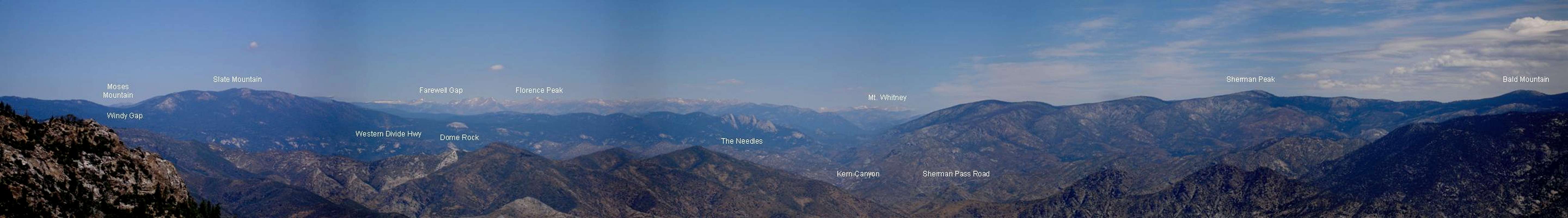  |
Getting There
The Baker Point Trail is accessible June through November, weather permitting. One way to get to the trailhead is from the small community of Sugarloaf. From Sugarloaf, take Forest Road 23S16 (paved) and go east up and over Portuguese Pass. Turn right on Forest Road 23S02 (unpaved). From here it is about 4 miles to the end of the road where the Baker Point Trailhead is. The trail is signed 32E37.You can also get to the trailhead from the community of Johnsondale. From Johnsondale drive east on County Road M-50 for 4 miles to Forest Road 23S16. Go south on this road for approximately 20 miles until you reach Forest Road 23S02. Turn left on 23S02 and follow it to the end.
One other approach to the trailhead is from Hwy 155. Near the Greenhorn Summit on Hwy 155 take Forest Service Road 24S15 north to Forest Road 23S16. Turn right and drive approximately 5 miles until you reach Forest Road 23S02. Turn right on 23S02 and follow it to the end.
Link to Sequoia National Forest Map based on USGS Tobias Peak Quad
Click here to buy a Sequoia National Forest map
If you look carefully with binoculars to the east you can see the Baker Point Lookout from the trailhead. It is partially hidden behind a pine tree. The trail to the Lookout Tower is about 1.5 miles each way. There is about 400 feet of elevation gain and the trail is rated as moderately strenuous. Parts of the trail are narrow, rocky, and steep so be sure to wear sturdy hiking boots. Most of the trail is sunny and exposed to the elements so bring sunscreen, plenty of water, and a wind breaker.
Along the trail you will see extensive rock outcrops which are covered with the colorful purplish pink flowers called Pride of the Mountain (Penstemon newberryi) in early summer. Views along the trail and at the lookout stretch north all the way to Mt. Whitney, south to the Piute Mountains south of Lake Isabella, west to Tobias Lookout, and east to Bald Mountain and Cannell Peak. Look carefully and you can see where the McNally Fire of 2002 burned in the Kern Canyon below. This fire at 150,000 acres was the largest wildfire in Sequoia National Forest in recorded history.
 Pride of the Mountain
Red Tape
No permits are needed to park at the trailhead or hike to the lookout. Please practice Leave No Trace ethics when you visit this area!Camping
Nearby campgrounds include Frog Meadow and Panorama. Both of these campgrounds are free and have pit toilets, picnic tables, and fire rings. You must bring your own water and a campfire permit is required. They can be obtained free of charge at any Forest Service, Bureau of Land Management, or CA Department of Forestry office.You can also disperse or dry camp. Pull into a turnout off of any Forest Service road, make sure you have a campfire permit, and pack out what you pack in!
There is also a cabin available for rent at Frog Meadow. Click here for more info!
 Campsite at Frog Meadow
External Links
Sequoia National ForestLookouts of the Sequoia National Forest
Buck Rock Foundation
A trip report to Baker Point and nearby areas
Weather Forecast for the Tulare County Mountains
Weather Forecast for the Kern County Mountains
Unique and Rare Plants found on Baker Point
For those of you that care about such things :)

Kern Swertia Swertia tubulosa
Coville's mule-ears Agnorhiza invenusta
Dwarf Maple Acer glabrum torreyi
Davidson’s rockcress Arabis davidsonii.
Kern frasera Frasera tubulosa
Piute cypress Cupressus nevadensis
Muir’s raillardella Raillardella muirii
Kern Canyon larkspur Delphinium inopinum
Needles buckwheat Eriogonum breedlovei shevockii
Whitney goldenbush Haplopappus whitneyi
More info...
The Baker Point Lookout was constructed in 1950. It has not been manned since 1986. Neaby Tobias Peak Lookout and Needles Lookout are manned in the summertime.For more info, please contact:
Sequoia National Forest
Giant Sequoia National Monument
Tule River and Hot Springs Ranger Districts
32588 Hwy 190
Springville, CA 93265
(559) 539-2607
Internet: www.fs.fed.us/r5/sequoia