
-
 11503 Hits
-
 87.31% Score
-
 24 Votes
|
|
Mountain/Rock |
|---|---|
|
|
40.46109°N / 121.49892°W |
|
|
Shasta |
|
|
Hiking |
|
|
Summer |
|
|
8753 ft / 2668 m |
|
|
Overview

Crossing a small snowfield below Bumpass Mtn.
The best way to do this peak is by incorporating it into a loop with Bumpass Hell to make for and interesting little dayhike.
Getting There

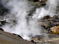
Bumpass Hell
South approach from Interstate 5
From the Bumpass Hell trail: From I-5 at Red Bluff go east on Hwy 36 towards Mineral. Turn north at the junction with Hwy 89 and go north 11 miles through the park entrance to the parking overlook. Take the trail to Bumpass Hell down about a half mile then break trail to the left and hike east a half mile to the summit of Bumpass Mountain. Hiking further down the trail another half mile from the break off point brings you to the steaming mud pots of Bumpass Hell.
From King Creek Campground via the Crumbaugh Lake/Boiling Springs Trail: From I-5 in Redding go east on Hwy. 36 toward Mineral. Turn north at the junction with Hwy. 89 and go through the park 14.5 miles over the high point by Lassen Peak and down to the turn to Kings Creek Campground. Turn right and go .5 miles to the campground.
The direct approach is a straight scramble to the west about a mile right from the trailhead.
For the Kings Creek/Bumpass Hell loop: Take the Boiling Springs/Crumbaugh Lake Trail .7 miles. Take the trail to the right around Boiling Springs Lake 2 miles to Bumpass Hell. Continue through Bumpass Hell and up the trail about a half mile and break trail to the right. Hike about a half mile to the top of Bumpass Mountain. Once on the summit continue down the bouldery then forested east slope about a mile back to the Kings Creek trailhead. This is an easy 5 mile loop and the most interesting way to hike this peak.
North approach from Interstate 5
From I-5 in Redding go east 46 miles on Hwy. 44 to Hwy. 89. Turn right into the park on 89 and drive 17 miles around Lassen Peak to Kings Creek trailhead.
Continue another 6 miles up past Lassen Peak to the parking lot overlook from the Bumpass Hell trailhead.
Red Tape

Boulder hopping near the summit.

Eagle and Lassen Peaks from below Bumpass Mtn.
Camping

Mt. Conard and Bumpass Hell below from Bumpass Mtn.
More camping and lodging info is available at the Lassen Volcanic National Park page.
Current road and weather conditions

Prospect Peaks from Bumpass Mtn. east slope
Etymology

Bumpass Mtn. and Mount Helen from the Lassen Peak Trail
Bumpass Hell
"In 1864 Kendall Vanhook Bumpass, a well known hunter and mountain man, discovered Bumpass Hell, the largest geothermal feature in Lassen Park. He was also the first person to accidently step through the thin crust and suffered a severe burn. The name Bumpass Hell remains a warning against careless wandering in the most active geothermal feature of the park"
THE STORY BEHIND THE SCENERY by Ellis Richard
External Links
Bumpass Hell - Lassen Volcanic National ParkWILLHITEWEB.COM