
-
 25185 Hits
-
 82.14% Score
-
 15 Votes
|
|
Mountain/Rock |
|---|---|
|
|
41.72000°N / 122.2224°W |
|
|
8280 ft / 2524 m |
|
|
Overview
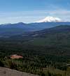
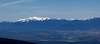
Goosenest Mountain is an 8280' peak in the Cascade range of Northern California and is about 20 airline miles from Mt.Shasta. I decided to create this page because there is so little written about this mountain in print or on the internet. It is such a prominent peak anywhere along the 1-5 stretch between Mt. Shasta City and Yreka and the Hwy 97 stretch between Weed and Klamath Falls Oregon that a detailed route description was needed.There are two routes up the mountain, one of which I have done- The Bob Rath Road trail, so for this description I will comment on the one I have done.
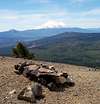
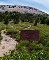
The first half of the trail is a pretty direct approach to the designated forest service trail that leads to the summit. You can see most of the trail blazing straight up the south face of the mountain so there is no guess work in trail finding. The trail is scree filled with loose sand so there is some slippin and slidin, especially on the way down. After about 1 mile of steady and steep climbing you hook up with the designated trail that you will see on maps of the mountain and turn left (west). Once on the trail you basically traverse the south face of the mountain for about another mile until you reach the rim of the crater and what appears to be an above ground grave. At the summit rim there is a wood post sticking out of the ground where it appears a sign once was. From this point you turn right (east), follow the trial along the crater rim and ascend about 300 vertical feet over 1/2 of mile until you reach the summit register.
 |  |
Getting There
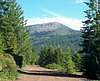
With the maze of forest service roads that you will encounter on your drive, following my description is advisable.From the Central Weed exit in Weed, Ca., follow Highway 97 north towards Klammath Falls for about 20 miles to the Herd Peak Lookout Road on your left. The entrance to the road is just pass a scenic overlook on your left, set your odometer to zero. The Forest Service has designated this road 45N22, this will be your road of travel for approximately the next 6.5 miles (all distances are approximate). At 2.8 miles from the freeway turnoff you will come to a split and a sign that reads "Herd Peak L.O. 4" with an arrow pointing left. You want to go right, continuing on 45N22. The sign designating the road at the split was torn up pretty badly at the time of this writing so when you see the busted road sign you know you are on the right road. Also, at this point, the road will become the red volcanic type, whereas the road in has been the gray, gravel type.
At 4 miles, you will come to a three way split in a meadow with a road going to the left, a road going straight and a road going right- continue on the road to the right . At approx. 6.7 miles there will be an unmarked road on your left and a sign on your right that says "45N22 7mi." Turn left on the unmarked road-45N22C- and continue another approx. 2.2 miles until you come to the cinder pits.
Continue straight ahead on the road for about 50 feet and you will see the sign "Bob Rath Road" on the right.Park here or follow the road around to the cinder pits and park there.
 |  |  |  |  |
Red Tape
No permits or summit fees are required unless you are camping over night. No parking pass is required either.When To Climb
(As of writing this)The road in was under snow by November '04 and it probably didn't open this year until mid May('05). People go snow mobiling up here in the winter so it is possible to summit during the snow season but the steep slopes of the mountain don't permit a lot of snow to stick.It's best to climb from May-October snow conditions permitting.