
-
 16720 Hits
-
 78.1% Score
-
 9 Votes
|
|
Mountain/Rock |
|---|---|
|
|
37.55990°N / 121.6063°W |
|
|
Alameda |
|
|
Hiking |
|
|
Spring, Summer, Fall, Winter |
|
|
3675 ft / 1120 m |
|
|
Overview
Cedar Mountain is a northern Diablo Range peak located in Alameda County. It is the county’s third highest peak, just 167 feet lower than Discovery Peak, the county highpoint. Like Discovery Peak, Cedar Mountain is also a California Coastal listed peak and is accessed from Del Valle Regional Park in Livermore. More specifically, it is the highpoint of Cedar Mountain Ridge, a massive ridgeline that rises from hills east of Lake Del Valle and extends 6 miles further southeast. The ridgeline is flanked on either side by steep slopes that elevate out of two deep, narrow canyons, both with seasonal creeks; to the west is the Arroyo Valle, and to the east, the Arroyo Mocho. The summit itself is uninspiring having been bulldozed flat and topped off with an unsightly communication tower, but its location on Cedar Mountain Ridge (known for rare, endemic plant communities) makes it a unique destination for hikers and naturalists alike.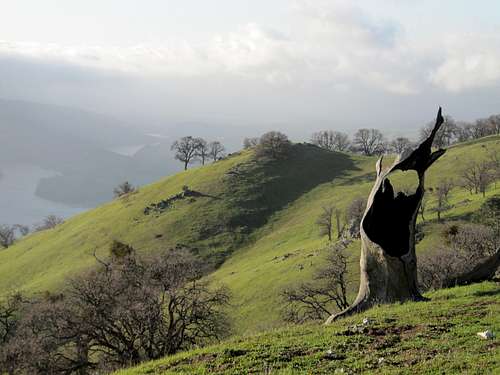 Western slopes of Cedar Mountain Ridge.
 Western slopes of Cedar Mountain Ridge.
Summit View
Small trees and brush block the views intermittently, particularly those to the north and west which respectively reveal distant views of Mount Diablo and the Ohlone Wilderness’ Rocky Ridge. The southern and eastern views are the least obstructed and most interesting. To the east, 1800 feet below, the Arroyo Mocho cuts a narrow valley through which Mines Road travels. Located further east are two obscure San Joaquin County peaks situated within earshot of one another: 3033-foot Eagle Mountain and 2865-foot Bald Mountain. Near to the south stands Man Ridge, to the southeast, Mount Wallace, a 3112-foot benchmarked peak that separates Alameda and San Joaquin County. More familiar peaks include Eylar Mountain, due south, and Mt. Boardman North, further to the southeast. Western slopes of Cedar Mountain Ridge.
 Summit of Cedar Mountain.
Getting There
Cedar Mountain can be accessed from Mines Road which is an east route or from Del Valle Regional Park which is a west route. Click on the hyper-link in this sentence for a trip report of an east route. The following information represents a west route. From the day-use parking area, described in the “directions” section below, walk back across the bridge and then walk south connecting to a service road that heads east/southeast. You will pass Caballo Loco, a park service yard and a park residence. Connect with the Black Sage Trail which takes you to the park boundary. You can also connect with the Black Sage Trail via Cedar Mountain Trail located just east of the family campground across Arroyo Valle Creek. There is no bridge here so the crossing may result in wet feet. At the park boundary utilize jeep trails that rise and snake their way up steep slopes of open grassland and stands of Knobcone and Digger Pine. The topography here is represented on the USGS Mendenhall Springs Quadrangle. To save time you may want to go overland, particularly when the jeep trails veer north. As you rise in elevation the views of Del Valle Lake, Lang Canyon and the Arroyo Valle open up dramatically. Upon reaching Cedar Mountain Ridge follow it southeast until you reach the highest point of Lang Canyon. Pick up connecting jeep trails that continue along Cedar Mountain Ridge and then cut in a more direct easterly direction. You will pass through a forested area where you may find an abundance of endemic plant-life. The topography is now represented on the USGS Cedar Mountain Quadrangle. At a four-way junction, go north one-quarter mile to a fork in the road. Go right. Notice communication towers to the north at the summit of Cedar Mountain. Take a cross-country shortcut or connect with the service road that ends at the summit complex. Forested heights of Cedar Mountain Ridge.
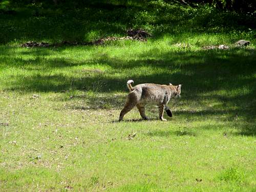 Bobcat above Lang Canyon.
Driving Directions
Del Valle Regional Park is located on Del Valle Road off Mines Road south of Livermore. Exit I-580 eastbound or westbound in Livermore at North Livermore Avenue. Head south and proceed through town (North Livermore Avenue will become South Livermore Avenue in town). Approximately 1.5 miles outside of downtown Livermore turn right at Mines Road. Drive another 3.5 miles and continue straight on Del Valle Road (Mines Road turns left). The park entrance is about four miles ahead. Pay entry fees at the kiosk and ask for a free park map. Drive into the park, crossing the bridge and immediately turn right and park at the day-use parking area not far from the bridge. Old Barn upper slopes of Cedar Mountain Ridge.
 Cedar Mountain Falls.
Camping
Camping is available nearby at Del Valle Reservoir in Livermore.Red Tape
At the time of this writing, Cedar Mountain is private property To hike here legally, you will need permission from the landowners.External Links
List of Alameda County Summits.Photos from hike to Cedar Mountain.
Mendenhall Springs Quadrangle.
Cedar Mountain Quadrangle.