
|
|
Mountain/Rock |
|---|---|
|
|
37.32240°N / 121.4074°W |
|
|
3804 ft / 1159 m |
|
|
Overview
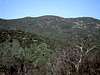
Mount Stakes is the high point of Stanislaus County, California, and thus, its easy class 1 peak would be the target of many a peakbagger. Unfortunately, Mt. Stakes is separated by a mile wide swath of private land to the nearest publicly accessible area (the northern boundary of Henry Coe State Park). This yields routes of varying legality:
The 93% Legal Route: Approaching entirely through Henry Coe State Park and only leaving the state park lands for the final mile of the ascent. The typical route starts at the southern Bell Station Gate and is approximately 50 miles roundtrip. This entire distance is hiking distance (or at best, mountain biking distance) as motorized vehicles are typically not allowed in Henry Coe State Park. However, one weekend each year, Henry Coe Park opens this gate for vehicular traffic for the first 12 miles of the route, allowing the hiking/biking roundtrip to be cut to approximately 30 miles.
The 73% Legal Route: Henry Coe's northern-most section is accessed from the nearest point on San Antonio Road; the park is traversed to the closest approach to Mt. Stakes. This yields a roundtrip distance of approximately 22 miles with 16 of that within the park.
The 0% Legal Route: Ranch roads are followed from the nearest point on San Antonio Road directly to the peak. This is entirely across private land and is not recommended. Total round trip distance is approximately 10 miles.
In addition to these routes, one could plan a route from either of the Henry Coe year-round public gates. These might yield shorter routes than the 50 mile Bell Gate route; however, they trade elevation gain and loss for distance while crossing the ridgelines in the north end of the park.
 |  |  |
Getting There
Typical approach routes leave from one of two locations, although any access point to Henry Coe State Park could be used.
Bell Station Gate: This entry point is typically used for the Backcountry Weekend Approach. The Bell Station Gate is located on the far southern side of Henry Coe State Park, five miles east of Casa de Fruta on Highway 152 (Pacheco Pass Highway).
Direct Approach: The direct approach location is located on San Antonio Road (this is the continuation of the Mt. Hamilton Road/Highway 130 on the east side of Mt. Hamilton) at the corner where the road turns north to Livermore.
 |  |  |
Red Tape
For the recommended Backcountry Weekend Approach, a reservation is required. More information is available at the Backcountry Weekend Website. Fees for the Backcountry Weekend are $20 for day use and $40 for overnight. The date for Backcountry Weekend is usually in late April each year.
Access via San Antonio Road is typically forbidden and requires special permits from landowners.
When To Climb
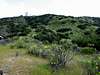
This long hike is best attempted in spring and fall when temperatures are moderate. Note that there are a relatively small number of creeks and other water sources in the northern reaches of Henry Coe, and these rapidly dry up during the summer months.
 |
Camping
Back country camping within Henry Coe State Park is allowed. This fee is included in the Backcountry Weekend fee; at other times, backcountry camping is $3 per person per night.
Mountain Conditions
Please see the Henry Coe State Park website for up-to-date conditions in the area.
External Links
- The easy (all private property) hike - Jan 13, 2004
- COHP
County High Points website, link to trip reports for Stanislaus County.
rgreene - Apr 28, 2005 5:51 pm - Hasn't voted
Untitled CommentI received a note that the Bell Station Gate may soon be open year round...
"The Pine Ridge Association is an official state park cooperating association. They have a newsletter and the topic of opening the gate has been the main issue for the last year. I personally have seen construction activity near that entrance. The plan was to open the gate this spring but the heavy rains this winter has delayed the construction."
If this happens, I will update the page to reflect accessability through this gate for the shorter Back Country Weekend mostly-legal route on a continuous basis.
Abraxas - May 23, 2005 10:34 pm - Hasn't voted
Untitled CommentFor anyone considering the hike from HWY 130, I can advise you that it takes nearly two hours to get there from San Jose. This is because you first have to crest Mt. Hamilton on a windy road, descend all the way back down the other side, go up and over another minor ridge, and then down to a meadow to park. There is no parking area per se, but one car can park on the side without restricting access to the gate.
fram - Jul 19, 2005 2:28 am - Hasn't voted
Untitled CommentI found it easier to follow a ridge that divides Red and Pinto creek basins up to the summit road. It's a little of bushwacking in chaparral, but not so bad; at least not as bad as dropping all the elevation into Pinto Creek canyon and bushwacking in the poison oak down there.