
-
 21422 Hits
-
 84.27% Score
-
 18 Votes
|
|
Mountain/Rock |
|---|---|
|
|
39.11510°N / 105.457°W |
|
|
Park |
|
|
Hiking |
|
|
Spring, Summer, Fall, Winter |
|
|
9189 ft / 2801 m |
|
|
Overview
 Bison Peak, McCurdy Mountain & South Tarryall Mountain
Perhaps from the east, the China Wall actually resembles a defensive rampart. From the west, the mountain is a gentle and indistinct rise about one mile to the east of Park County 77. Though not a particularly impressive peak in its own right, China Wall serves up delicious views of the Tarryall Mountains and even a distant view of lonely Pikes Peak.
Like many of its neighbors, China Wall is not a particularly high nor striking peak. It resides in a place of quiet beauty, of soft, rounded hills blanketed in Ponderosa Pine and studded by pink granite outcrops. Sit quietly here and wait for wildlife or simply observe the breeze in the trees and the gentle ebb and flow of the seasons.
Colorado Rank*: 2806th highest peak in Colorado
Prominence*: 419 feet
USGS Quad: Tarryall
Trails Illustrated Map: This peak is not covered by either Trails Illustrated #137 (Pikes Peak, Cañon City) nor by Trails Illustrated #105 (Tarryall Mountains, Kenosha Pass). If not using the USGS Quad, a custom topo (designed using National Geographic topo or MyTopo, for instance) is recommended).
*Rank and Prominence Reference: Lists of John
Getting There & Route Information
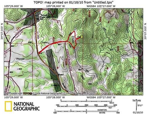 Route Map
 Getting There Map
Getting There Overview
China Wall sits just to the east of Park County 77 in eastern Park County, not far from the border with Douglas and Teller counties. This gentle, low mountain is easily accessible via FS 212 or FS 212 A. FS 212 is approximately 11 miles north on Park County 77 from Hwy 24 west of Lake George.
FS 212 Route
The overall level of effort (mileage combined with elevation gain) to reach the summit of China Wall will vary based on your preference, plus the off-road capabilities of your vehicle and the driver. With favorable conditions (dry road free of snow and mud, for instance) a competent driver with a high-clearance vehicle could drive nearly to the summit of China Wall. Many folks with a standard 4X4 may prefer to park at the junction of FS 212 and FS 212 A (ample parking is available in this saddle west of China Wall) and walk the remainder of the route to the summit of the mountain. Those without 4-wheel drive or those who simply want to feel like they earned this summit may hoof it the entire way from Park County 77.
Roundtrip Mileage: 2.25 miles roundtrip from Park County 77
Elevation Gain: 375 feet from Park County 77
 4WD routes around China Wall 4WD routes around China WallBy Jeremy Hakes |  China Wall from the east China Wall from the eastBy Jeremy Hakes |
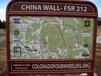
Red Tape
 Northeast from the summit
 Approaching summit from south
Much of the National Forest access along the Tarryall Valley is characterized by public access easements through private property lining the road/creek. Be respectful of the property rights of the owners who grant us access through their property.
Otherwise, there is little red tape governing recreational use in this part of the National Forest and there is no fee to access this area. Adhere to LNT (Leave No Trace) principals, observe fire ban when in effect and do not harass wildlife or allow your pet to do so.
Camping & Lodging
 Pikes Peak from the summit
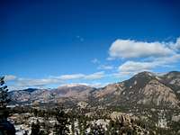 Bison, McCurdy & South Tarryall
FS 212 and FS 212A and Immediate Surroundings
A few rustic camp sites can be found along FS 212 and FS 212A. In fact, a camping sport exists almost on the summit of China Wall. These rustic, informal sites are available on a first-come first-served basis and are dry: No water, from a pump/well or other water body, is available, so pack water sufficient for your group size and the duration of your stay.
Designated National Forest Service Sites
The National Forest Service has a large selection of campgrounds in and around the Lake George area.
| Campground Name | Elevation | Sites | Nightly Rate | Reservations? | Notes |
|---|---|---|---|---|---|
| Blue Mountain | 8,200 ft. | 21 | $12 | Yes | Just a couple miles south of Lake George. |
| Spruce Grove | 8,600 ft. | 27 | $12 | No | Let the gurgling Tarryall Creek sing you to sleep. |
| Twin Eagles | 8,600 ft. | 9 | $8 | No | Must haul or purify drinking water. |
| Happy Meadows | 7,900 ft. | 8 | $12 | No | Situated along the South Platte River. |
| Round Mountain | 8,500 ft. | 16 | $12 | Yes | Drinking water, vault toilet and trash pickup. |
| Springer Gulch | 8,300 ft. | 15 | $12 | Yes | Situated within the Elevenmile Canyon; water, tables, fire grates. |
| Riverside | 8,000 ft. | 19 | $12 | Yes | Situated within Elevenmile Canyon; large grassy meadow with little shade. |
Cabins, Lodges and Hotels
Numerous cabins can be rented in and around Lake George. There are also a few cabins/lodges/dude-ranches along the Tarryall Creek catering especially to the fly fishing visitor. For example: Ute River Ranch
 Tarryall Valley Bighorn Sheep
Weather & Seasons
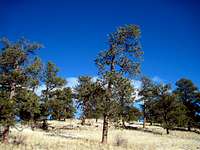 Grassy Ponderosa Savannah
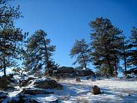 Summit outcrop
Summer: The route can be a bit hot and dusty in the summer, but the road should be dry and accessible and the breezes on top pleasant.
Spring: The snowpack is less deep here than in the high country and melts out faster than higher areas to the west. None-the-less, expect post-holing through unconsolidated snow drifts in the trees.
Fall: The aspen coating the slopes of this peak and surrounding neighbors make this area a golden-hued heaven in the fall.
Winter: Thanks to proximity to Park County 77, this peak is accessible year-round, though deep snows/drifts and 4x4 road closures could add a couple miles to the roundtrip journey to the summit of this peak and back to your parking.
 Moonrise to the east