
-
 18755 Hits
-
 89.39% Score
-
 29 Votes
|
|
Mountain/Rock |
|---|---|
|
|
39.31190°N / 105.6106°W |
|
|
Park |
|
|
Hiking |
|
|
Summer, Fall |
|
|
11902 ft / 3628 m |
|
|
Overview
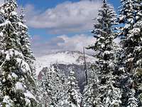
 Looking north from near the summit of North Tarryall Peak
12 Oct 2008
Less than one hundred feet shy of being a 12er, North Tarryall Peak strikes a strong, quiet stance at the northernmost end of the Tarryall Mountains. Appearing relatively gentle from many points of view, Tarrayall Mountain shows its most ruggedly handsome visage to those admiring this peak and its neighbors from the south-southwest. Those willing to bushwack through dense timber and downfall are rewarded by the broad, wind-blown, outcrop-studded summit of North Tarryall Peak. The views of nearby Kenosha Mountains 12ers are certain to delight.
Colorado Rank: 1357
Eleveners Rank: 45
Prominence: 882
Mountain Range: Retirement Range, Tarryall Mountains
Rank and Prominence Reference: Lists of John
Getting There & Route Overview
As the crow flies, North Tarryall Peak is located about 5 ½ miles due-north of the Tarryall Reservoir and about 10 ½ miles southeast of Kenosha Pass. The Tarryall Mountains are sandwiched between Park County 77 to the southwest and the Kenosha Mountains to the northeast. Click on map for larger view
- From Colorado Springs: Hwy 24 West to Lake George. Just past lake George, turn right (northwest) on Park County 77 (Tarryall Road). Use caution with the minefields of potholes. Between dusk and dawn, deer and elk are incredibly numerous - watch your speed!
- From Denver: Take Hwy 285 to the town of Jefferson and turn left on Park County 77. (Keep an eye out for free range cattle.)
| Route | Approximate Mileage | Approximate Elevation Gain | Special Note | Driving Directions |
|---|---|---|---|---|
| Lost Pass | 4.7 miles roundtrip | 1,232 ft. | Off-trail from parking to summit | From Park County 77, head north on Rt 39. Follow Rt. 39 to “T” intersection with FR 56 (Lost Park Road) and turn right/east. Follow FR 56 to Lost Pass at 10,670 ft. |
| Nate Stultz | 8.5 miles roundtrip | 2,200 ft. | On-trail until last mile to summit | From Park County 77 head north on FR 141 (Cabin Spring Road, about 2 miles north of the Tarryall Reservoir) and park at the Nate Stultz TH. |
Red Tape
 One of the Kenosha Mountains from the summit
12 Oct 2008
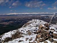 Looking west across South Park from the summit.
12 Oct 2008
There exists little or no red tape in this part of the National Forest. North Tarryall Peak sits outside of the protection of the Lost Creek Wilderness.
 Looking Southeast Toward the Summit
12 Oct 2008
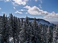
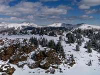
 Looking toward the Kenosha Mountains
12 Oct 2008
Camping & Lodging
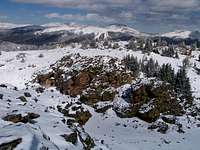
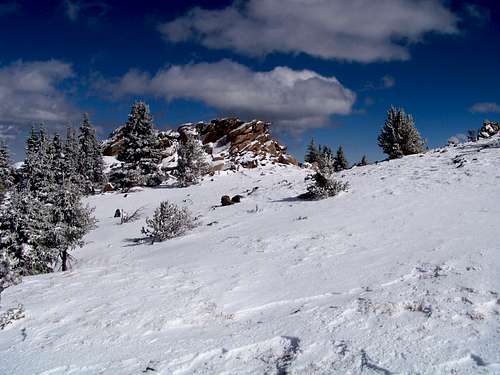 Rock outcrop on the summit plateau of North Tarryall Mountain
12 Oct 2008
Lost Pass Trailhead
At least three fire rings are present right off the dirt road at the summit of Lost Pass. This will be dry, rustic camping very close to the road with little privacy.
Along Rt. 39 & 56
Several campsites off Rt 39 provide views of Mt. Silverheels, Buffalo Peaks, Horseshoe Mountain, Bald Mountain and Mount Guyot and other 13ers and 12ers that will bring tears to your eyes. Competition for these sites, however, is intense in the summer, with large armadas of ATVs and RVs staking weekend claims to favorite haunts.
South end of Hwy 77
The south end of Hwy 77 (Tarryall Road), near Hwy 24, provides several established U.S. Forest Service camping areas. South Park Ranger District Lake George Area Campgrounds include: Riverside, Spillway, Happy Meadows, Round Mountain, Spruce Grove, and Twin Eagles. Please contact the district office at (719) 836-2031 if you have additional questions about the campgrounds in the South Park Ranger District.
North end of Hwy 77
The north end of Park County 77 and dirt spur roads are abound with off-road campsites.
Cabins, Lodges and Hotels
Numerous cabins can be rented in and around Lake George. There are also a few cabins/lodges along the Tarryall Creek catering especially to the fly fishing visitor. For example: Ute River Ranch. There are a few hotels in Fairplay.
 Snow Dusted Kenosha Mountains
 12 Oct 2008
 Hoof Tracks on North Tarryall Peak Summit Plateau
12 Oct 2008
Weather & Seasons
Due to seasonal closures of Forest Service Roads, North Tarryall Peak is accessible between early summer and late Fall, depending on snow pack. The access roads in this area melt out earlier and get snowed-in later than many higher-altitude, heavier-snowpack climbing areas in Colorado. Nonetheless, during snow season this mountain is accessible only to the intrepid winter hiker looking for a multi-day outing or to those willing to opt for a snow-machine assisted approach.External Links
Pike & San Isabel National ForestsPike National Forest Recreation Map
 Fresh October Snow on Silverheels
 12 Oct 2008