
-
 5299 Hits
-
 87.76% Score
-
 25 Votes
|
|
Mountain/Rock |
|---|---|
|
|
44.26641°N / 6.99697°E |
|
|
Piedmont |
|
|
Hiking, Mountaineering, Trad Climbing, Ice Climbing, Scrambling, Via Ferrata, Skiing |
|
|
Spring, Summer, Fall |
|
|
9875 ft / 3010 m |
|
|
Overview
Cima del Corborant 3010 m
Cima del Corborant m. 3010 is a summit located in the Maritime Alps and belonging to the main alpine watershed on the border between Italy and France, just to the North of Passo Corborant 2925 m. It’s the second highest peak of the Western Maritimes Alps after Monte Tenibres and together with this latter it’s the only Threethousander in this part of the chain. Corborant has the shape of a fine pyramid and projects towards East the buttress of Monte Laroussa, which divides the two valleys of Ischiator and San Bernolfo. The Italian side of the mountain is located in the municipality of Vinadio, high valley of Stura di Demonte, while the French side belongs to the municipality of St- Etienne-de-Tinée, vallée de Tinèe.
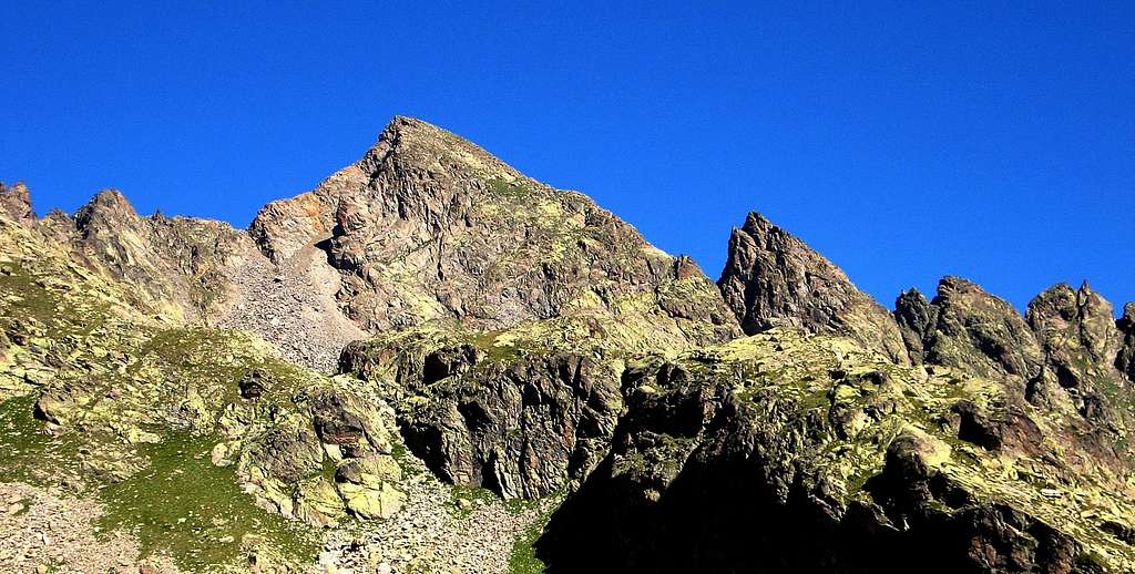
Corborant is a very interesting mountain, one of the most significant peaks of the Western Maritimes, surrounded by spectacular lakes on both sides, French and Italian. It’s a popular mountain, very often climbed, in reason of its easy accessibility through the three normal routes – two ones rising from the Valle Stura (italian side), the third one from St- Etienne-de-Tinée (French side) - that don't oppose relevant technical difficulties.
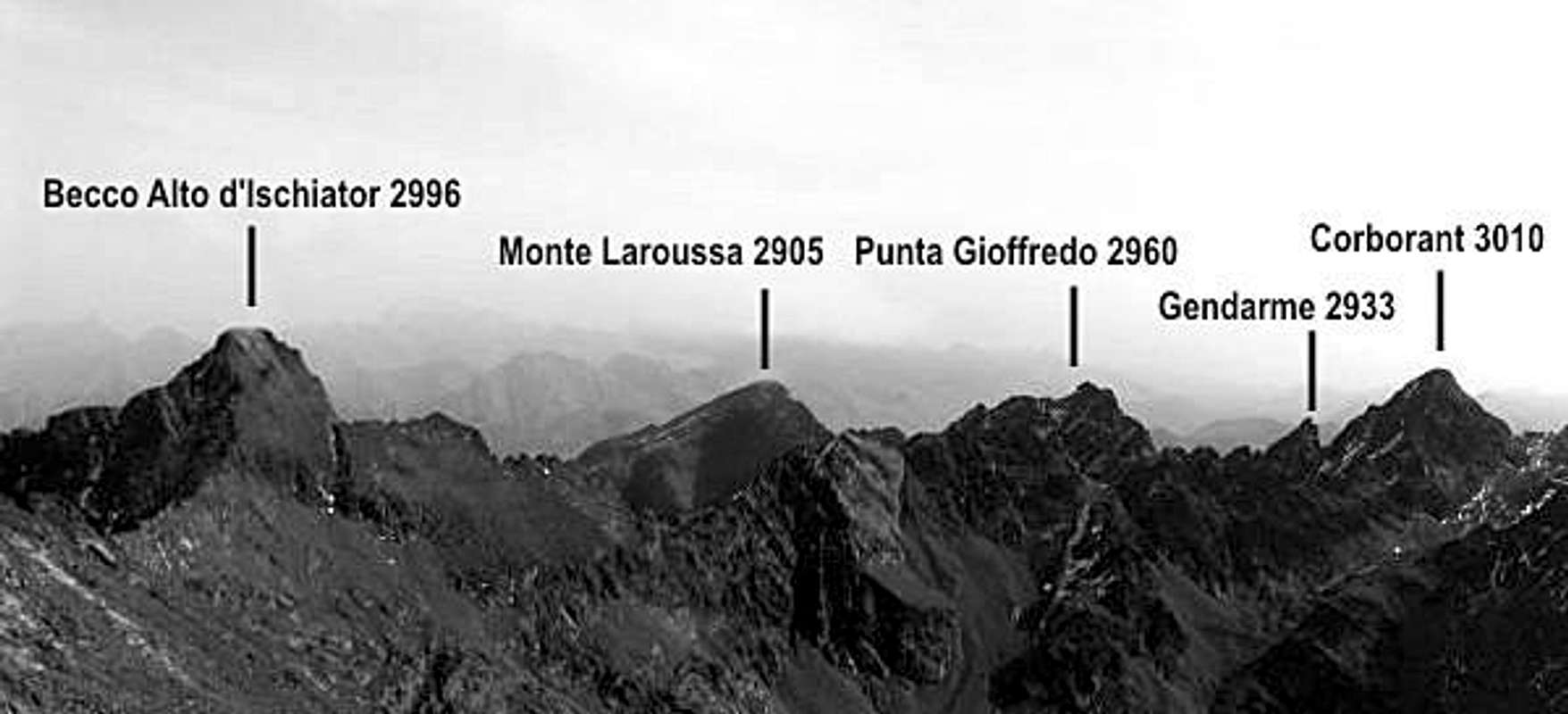
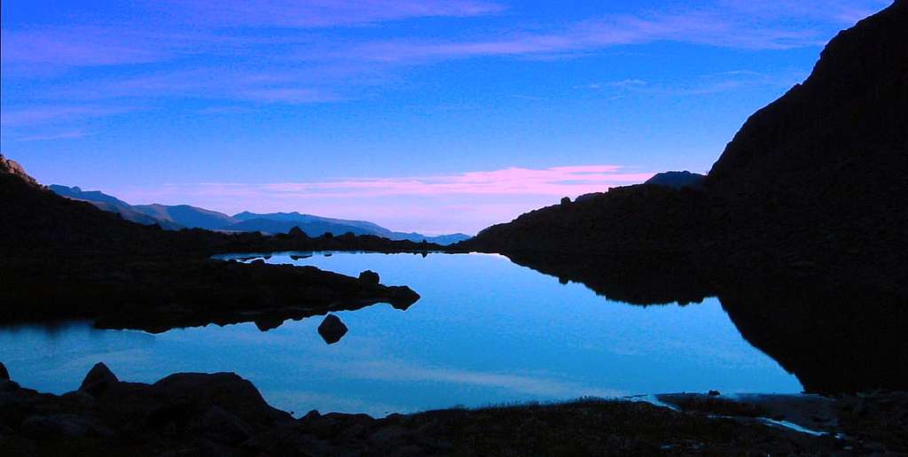
Moreover, overcoming Corborant the surrounding peaks in height, the summit panorama is spectacular, being open over Monte Tenibres, Monte Matto, Argentera and the near Lake Rabuons, as well as a number of smaller lakes. From the geological point of view, it's interesting to note that the Corborant consists of some of the oldest rocks belonging to the well-known Argentera crystalline massif.
Getting There
Italian side – From Cuneo take the road to Colle della Maddalena and Valle Stura di Demonte, reaching the villages of Demonte and Vinadio, then the little settlement of Pianche, where a narrow road starts on the left of the main one. From here there are two different possibilities to climb the mountain: through the Ischiator Valloon or, longer, through San Bernolfo Valloon. Both the valloons are approachable by the road starting from Pianche and getting to Bagni di Vinadio (5 km. from the main Valle Stura road); at beginning of the village of Bagni di Vinadio, beyond the thermal baths, the road forks: the right branch rises to the church, reaches the village of Besmorello m. 1451 and goes into the Vallone dell'Ischiator, reaching a parking where the road is closed to the cars. The left branch leads to the village of Strepesi m. 1281, then San Bernolfo m. 1702.

French side – From St. Etienne de Tinée m. 1144 reach the St Antoine bridge. From here the path to the Refuge de Rabuons starts


Normal routes overview

There are three Normal routes to climb Corborant. On the Italian side there are two normal routes, one rises along the valley of Ischiator and the Refuge Migliorero, reaching the summit from the North East, the second one goes along the valley of St. Bernolfo and Passo Corborant. The third Normal routes gets to the summit from the Refuge de Rabuons, reaching Passo Corborant, like the previous route, from the French side.
A - Italian Normal route from Ischiator Valloon through Rifugio Migliorero
Difficulty: F+ (Alpine scale)
Difference in level: 910 m from Rifugio Migliorero
Description: from Rifugio Migliorero take the path P26 to the upper lake of Ischiator, where it must be left to climb a rocky gully (frequently snowy in early summer) that leads to the fork along the Eastern ridge, separating Corborant from Punta Gioffredo. From here climb the ridge to the summit. The fork on the east ridge is also accessible from the side of San Bernolfo, going to the higher Lake Lausfer (see the following route - B)

B - Italian Normal route from San Bernolfo Vallon
Difficulty: F (Alpine scale)
Difference in level: 1300 m from San Bernolfo
Description: this route has a higher difference in level than the previous one. From San Bernolfo go up towards the lakes Lausfer, following at first the path P23, then the path P47. Near the upper Lausfer Laker leave the main path and follow a track rising to Passo del Corborant. From here follow a ledge crossing the West side, then scramble up a gully on the right, leading to the summit
C- French Normal route from St- Etienne-de-Tinée through the Refuge de Rabuons
Difficulty: F (Alpine scale)
Difference in level: 500 m from Refuge de Rabuons
Description: from the shelter follow the trail to Passo del Corborant m. 2925. From the pass same itinerary as the previous route: follow a ledge crossing the West side of the peak, then scramble up a gully on the right, leading to the summit.

Essential gear
A normal high-mountain equipment is required. Be aware that the ground is rough, so a rope could be helpful to people with little experience. Earlier in the season (June) there is always snow or ice, therefore ice axe and crampons are essential.
Red Tape
 along the Ischiator Valloon")
No fees no permits required to climb. Corborant anyhow is located in an area which is under the authority of two Natural Parks: the Parco Alpi Marittime on the italian side (East), established in 1980, twinned with the Mercantour National Park on the french side (West). Obviously the area is subject to some rules:
- Free camping is not allowed and fires are forbidden
- Bivouac is authorized only at more than 1 hour’s walk from Park boundaries or from access roads
- The whole fauna and flora is protected
- Dogs must be leashed
Huts
 - Ischiator Valloon")
- Rifugio Migliorero m. 2100 - C.A.I. (Club Alpino Italiano) Sez. Fossano Approach: 2 hours from Ischiator Valloon
")
Refuge de Rabuons m. 2523 - C.A.F. (Club Alpine Sec. des Alpes Maritimes) Approach: 4,15 hours from St-Etienne-de-Tinée
Other accomodation in Valle Stura di Demonte
Different kinds of accommodation in San Bernolfo, Bagni di Vinadio, Vinadio and Demonte.
When to climb
Mountaineering: from June to September
Ski-mountaineering: from March to May
Meteo
Meteo Regione Piemonte
Meteo France montagne Mercantour
Guidebooks and maps

- Alpi Marittime Vol. II - E. Montagna, L. Montaldo, F. Salesi, Guide dei Monti d'Italia
- Vette delle Alpi - Andrea Parodi -
Maps: ICG Val Maira Grana e Stura 1:50000 - Fraternali N. 13 Alta Valle Stura di Demonte 1:25.000
External Links
- Argentera Natural Park
- Mercantour National Park