
-
 24460 Hits
-
 88.91% Score
-
 28 Votes
|
|
Area/Range |
|---|---|
|
|
44.17749°N / 7.30693°E |
|
|
Hiking, Mountaineering, Trad Climbing, Sport Climbing, Ice Climbing, Big Wall, Scrambling, Skiing |
|
|
Spring, Summer, Fall |
|
|
10817 ft / 3297 m |
|
|
What's new on this page?
PAGINA DOTATA DI TRADUZIONE IN LINGUA ITALIANA - THE ITALIAN TRANSLATION ADDED TO THE PAGE (2021, March)
Overview
Maritime Alps
The Maritime Alps are a wild and complex chain lying in the Southern end of Western Alps. The main ridge runs on the Italy-France boundary from Colle di Tenda (1871 m a.s.l., 44°09’06’’N; 4°52’30’’O) to the South-East to Colle della Maddalena (1996 m a.s.l., 44°25’17’’N; 5°33’15’’O ) to the North-West. As their name means, Maritime Alps are a part of the Alps located close to Mediterranean Sea (sea = mare in italian). The Italian side belongs to the Cuneo Province, Piemonte Region, while the French one mainly belongs to the Departement des Alpes Maritimes (06) and Alpes de Haute Provence (04). Starting from North, at first the chain runs from North-West to South-East from Colle della Maddalena - or Col de Larche in French (road col)- to Colle di Ciriegia (walking col). In the Southern part the chain runs from East to West from Colle di Tenda (road col) to Colle di Ciriegia (walking col).
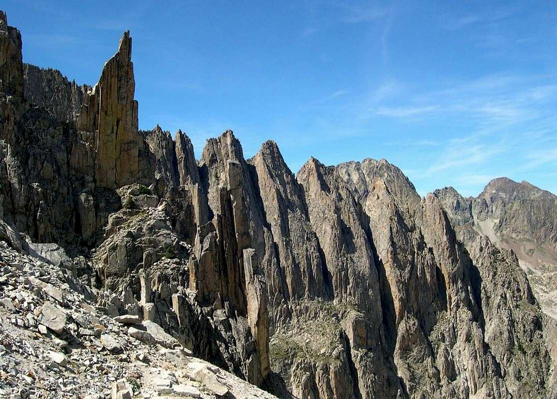
The Maritime Alps are very different from the Ligurian Alps, with which they are often confused. Despite the name and their position near the Mediterranean Sea (Ligurian Sea) it is a mountain range with marked alpine characteristics, also from the point of view of the climate, where the typical aspects of the Western Alps are already evident. The altitudes are quite high, several mountains in fact exceed the 3000 meters in height. Majestic peaks, high walls, rocks, gullies and valleys of glacial origin, alpine lakes, the landscape anticipates that one of the Northernmost sectors of the Western Alps. In the Maritime Alps the granite rocks prevail, as in the Argentera massif, but there are also limestone rocks like in the Valle Stura di Demonte.
Le Alpi Marittime sono una catena selvaggia e complessa situata all'estremità meridionale delle Alpi Occidentali; la cresta principale corre sul confine Italia-Francia dal Colle di Tenda (1.871 mt slm, 44 ° 09'06''N; 4 ° 52'30''O) a sud-est fino al Colle della Maddalena (1.996 mt slm, 44 ° 25'17''N; 5 ° 33'15''O) a nord-ovest. Come dice il loro nome, le Alpi Marittime sono una parte delle Alpi situata vicino al Mar Mediterraneo. Il versante italiano appartiene alla provincia di Cuneo, regione Piemonte, quella francese appartiene principalmente al dipartimento delle Alpi Marittime (06) e alle Alpi dell'Alta Provenza (04). A partire da nord, inizialmente la catena si estende da nord-ovest a sud-est dal Colle della Maddalena - o Col de Larche in francese (passo stradale) - fino al Colle di Ciriegia (passo escursionistico. Nella parte meridionale la catena corre da est a ovest da Colle di Tenda (passo stradale) a Colle di Ciriegia (passo escursionistico).
Le Alpi Marittime sono molto diverse dalle Alpi Liguri, con le quali sono spesso confuse. Nonostante il nome e la loro posizione vicino al Mar Mediterraneo (Mar Ligure) sono una catena montuosa con caratteristiche decisamente alpine, anche dal punto di vista climatico, dove le caratteristiche tipiche delle Alpi Occidentali sono già molto evidenti. Le altitudini sono piuttosto elevate, diverse montagne infatti superano i 3000 metri di altezza. Vette maestose, alte pareti, rocce, calanchi e valli di origine glaciale, laghi alpini, il paesaggio anticipa quello dei settori più settentrionali delle Alpi Occidentali. Nelle Alpi Marittime prevalgono le rocce granitiche, come nel massiccio dell'Argentera, ma si trovano anche i calcari, come nella Valle Stura di Demonte.
Highest summits
Monte Argentera m. 3297, the highest of the range; Monte Stella m. 3262 Cima di Nasta m. 3108; Monte Matto m. 3097; Monte Gelas m. 3143; Il Baus m. 3067, Cima di Brocan m. 3054, Cima Paganini m. 3051, Corno Stella m. 3050; Monte Clapier m. 3045; Tenibres m. 3031; Corborant m. 3010
Argentera, Alpi Marittime highest summit
Main Subgroups
Brocan-Baus-Nasta, Argentera, Oriol, Bresses, Prefouns, Testa Malinvern, Lombarda, Lausfer, Corborant, Ischiator, Tenibres, Ubac, Enciastraia, Rocca dell’Abisso, Vernasca, Basto-Grand Capelet, Clapier-Maledia, Gelas, Agnel
Getting there
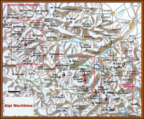
Italian side or Eastern side
The chain runs in its southern part from Ventimiglia to Colle di Tenda (SS nr. 20/E 74, Km 38). To reach the chain Central part it’s useful following from Cuneo Gesso Valley towards Valdieri and then either to S. Anna and Terme di Valdieri (NW side of Argentera Group) or Entraque (SE side of Argentera Group). To reach the Northern Side of the chain from Cuneo follow Stura Valley, from which on the left-hand side some secondary valleys lead to the foot of the main mountains (some valleys, such as Vallone di S. Anna and Valle del Rio Corborant, are provided with drivable roads; the Vallone di S. Anna road, starting from Vinadio, crosses the boundary at Lombarda Col mt. 2.351 mt a.s.l., leading to Isola, in the French side).
French side or Western side
From Nizza head toward North (following at first the road D6202 Route de Grenoble/Route des Grandes Alpes and then the road D2565) to St. Martin Vesubie (Km. 65), Isola and St Etienne de Tinee. From La Bollene, Roquebilliere, St Martin Vesubie, Isola the secondary roads allow to go up the valleys toward the main chain.
Versante italiano (Est)
La catena corre nella sua parte meridionale da Ventimiglia al Colle di Tenda (SS n. 20 / E 74, Km 38). Per raggiungere la parte centrale della catena è utile seguire da Cuneo la Valle Gesso verso Valdieri e poi verso S. Anna e le Terme di Valdieri (parte nord-occidentale del gruppo Argentera) o Entraque (parte sud-orientale del gruppo Argentera). Per raggiungere il versante settentrionale della catena da Cuneo seguire la Valle Stura, dalla quale sul lato sinistro alcune valli secondarie conducono ai piedi delle montagne principali (alcune valli, come il Vallone di S. Anna e la Valle del Rio Corborant, sono percorse da strade rotabili; la strada del Vallone di S. Anna, a partire da Vinadio, attraversa il confine sul Colle della Lombarda 2351 m. slm e porta a Isola, nel versante francese.
Versante francese (Ovest)
Da Nizza dirigersi verso nord (seguendo inizialmente la strada D6202 Route de Grenoble / Route des Grandes Alpes e poi la strada D2565) a St. Martin Vesubie (Km. 65), Isola e St Etienne de Tinee. Da La Bollene, Roquebilliere, St Martin Vesubie e Isola strade secondarie consentono di risalire le valli verso la catena principale.
Northern Sector
Northern sector main summits (in order of height)
Monte Tenibres m. 3031 - Corborant m. 3010 - Becco Alto d’Ischiator m. 2998 - Monte Enciastraia m 2955 - Cima las Blancias m. 2970 - Testa Malinvern m. 2939 - Monte Laroussa m. 2905 - Cima di Collalunga m. 2759 - Rocca di San Bernolfo m. 2681, Testa dell'Autaret m. 2763, Punta Maladécia m. 2745

|

|
Southern Sector
Southern sector main summits (in order of height)
Apart from the main boundary chain, two important subgroups are lying entirely in the Eastern side (Italy): Monte Matto Group and Monte Argentera Group. Inside the Southern sector is lying the highest summit of the chain: Monte Argentera or Serra dell'Argentera m. 3297

|

|
")
|
Other important summits: Cima di Nasta m. 3108 - Monte Matto m. 3097 - Cima della Maledia m. 3061, Corno Stella m. 3050 - Rocca dell’Abisso m. 2755 - Monte Clapier m 3045 - Monte Gelas m. 3143 Testa di Tablasses m. 2851 - Caire di Cougourde m. 2921 - Caire de Prefouns m. 2840 - Cima di Mercantour m. 2775 - Cima di Fremamorta m. 2731

|

|

|
")
|

|
Climbing and hiking
All the Maritime Alps offer a great opportunity of hiking, scrambling, climbing and mountaineering inside a beautiful and wild alpine landscape. The Argentera Group is the most important sector concerning mountaineering and climbing, and many interesting peaks and nice walls belong to this subgroup, such Corno Stella, with its famous South-West granite wall, and Cima di Nasta. Other intersting rock climbing areas are the Prefouns sub-group and the Cougourde sub-group. In the Maritime Alps you can also find several middle-mountain climbing walls, such in Valle Gesso and in Valle Stura.
Main trails
Both the "GTA Grande Traversata delle Alpi Piemontesi" trail in the italian side and "GR5 Grande Randonnée 5" trail in the french side are well-known and highly reliable hiking itinerary. The first trail is starting from Ponte della Rovina and running to Valle Stura. The second trail is starting from Larche and running to Nizza.
")
|

|

|
Tutte le Alpi Marittime offrono grandi opportunità di trekking, arrampicata e alpinismo in un contesto di grande bellezza paesaggistica, in ambiente alpini e selvaggi. Il Gruppo dell'Argentera è il settore più importante per l'alpinismo e l'arrampicata, comprendente molte cime interessanti e belle pareti, come il Corno Stella, con la sua famosa parete Sud-Ovest, e la Cima di Nasta. Altre aree interessanti per l'arrampicata su roccia sono il sottogruppo Prefouns e il sottogruppo Cougourde. Nelle Alpi Marittime si trovano anche diverse pareti di arrampicata di media montagna, ad esempio in Valle Gesso e in Valle Stura.
Principali sentieri
Sia il sentiero "GTA Grande Traversata delle Alpi Piemontesi" sul versante italiano sia il sentiero "GR5 Grande Randonnée 5" sul versante francese sono itinerari escursionistici conosciuti e di grande interesse. Il primo trekking parte da Ponte della Rovina e si dirige verso la Valle Stura. Il secondo trekking parte da Larche e si dirige verso Nizza.
Huts and Bivouacs
Eastern Side (Italy)
Huts
- Rifugio Guglielmo Migliorero m. 2100 - Rifugio Lorenzo Bozano at Corno Stella m. 2453 - Rifugio Dante Livio Bianco m. 1910 - Rifugio Gandolfo 1847 m - Rifugio Genova – Bartolomeo Figari 2015 m - Rifugio Lausa 2400 m - Rifugio Laus m1910 - Rifugio Morelli and Buzzi 2350 m - Rifugio Pace al Colle della Maddalena 1996 m - Rifugio Questa 2388 m - Rifugio Regina Elena 1800 m - Rifugio Remondino 2430 m - Rifugio Talarico 1750 m - Rifugio Zanotti 2200 m

|

|

|

Bivouacs
Barbero mt. 1670 - Baus mt. 2568 - Costi-Falchero mt. 2275 - Guiglia mt. 2437 - Varrone mt. 2090 - Vigna mt. 2880
Western Side (France)
Huts
Bousieyas m 1883 - Chastellar m 1507 - Chastillon m 2034 - Cougourde m 2090 - Rabuons m 2523 - Salese m 1724 - Ski Club Nice m 1519 - Vens m 2370
Lakes
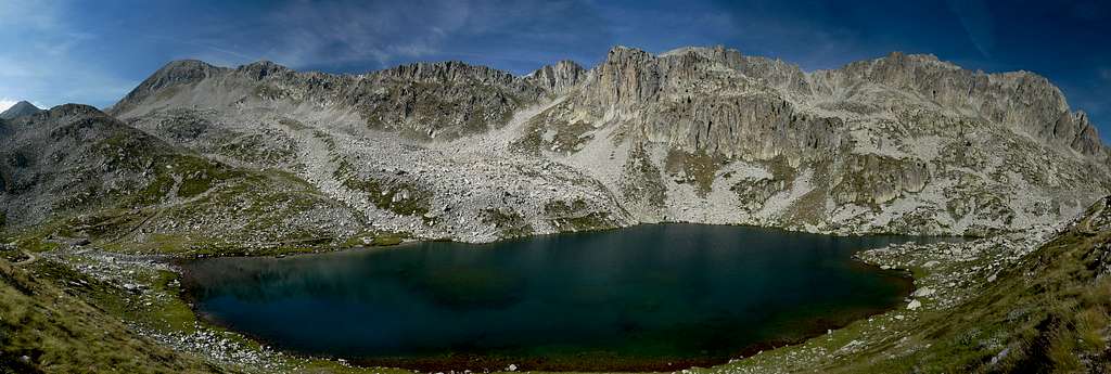
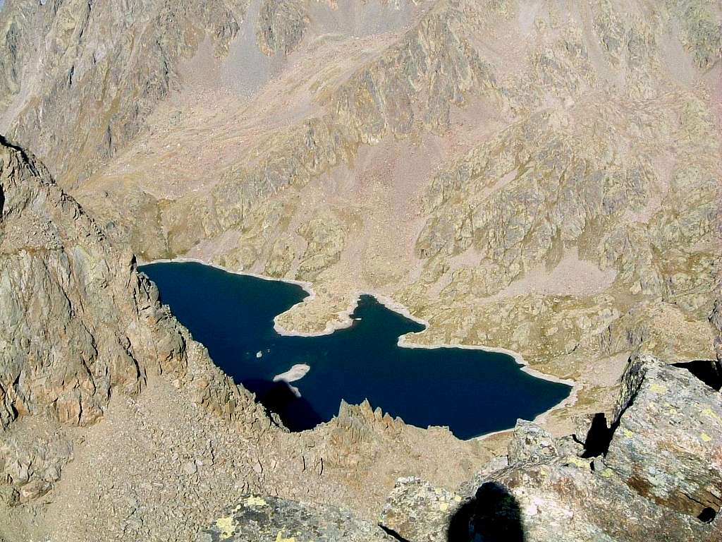
"There are over eighty lakes in the Maritime Alps, some set in the rocks, others lapped by the prairies. Each of these bodies of water, in which the surrounding peaks are reflected, has its own charm, a peculiarity in terms of shape, size and color. There are very small and lost, like those of Maledia, and deep and fishy, like those of Valmasca. There are, of course, artificial ones: some recent ones like the Chiotas basin, others belonging to the beginning of the century like the Mesches basin ended in 1914." (from Alpi Marittime I - CAI - Montagna/Montaldo/Salesi)
"Sono oltre ottanta i laghi delle Alpi Marittime, alcuni incastonati nella roccia, altri lambiti dalle praterie. Ciascuno di questi specchi d'acqua, in cui si riflettono le cime circostanti, ha un suo fascino, una particolarità per forma, dimensioni e colore. Sono molto piccoli e sperduti, come quelli di Maledia, e profondi e pescosi, come quelli della Valmasca. Ci sono, ovviamente, quelli artificiali: alcuni recenti come il bacino del Chiotas, altri dell'inizio del secolo come il bacino del Mesches terminato nel 1914. " (da Alpi Marittime I - CAI - Montagna / Montaldo / Salesi)-
")
|

|

|

|
")
|
Climate, Nature, Geology


Due to the location of the chain, it rains more than in the other parts of the Alps, mostly in spring and autumn (rain) and in late winter (important snow-falls). The French side (West) counts more rain-falls, because of the Atlantic perturbations coming from West. Many rare and endemic species live in Maritime Alps, due to the geographic position under the influence of sea in South side, to the typical alpine climate in the northern side and in the higher zone and to the ancient glacier’s action, rocks variety and man’s activity. No other place in alpine chain is so rich in animal and vegetable species. You can find both artic species as Ranunculus Glacialis and mediterranean species as Lavandula Angustifolia and Juniperus Phoenicea. But the most important endemic specie is Saxifraga Florulenta, which lives only in the small range from Mont Frisson and Vens Lakes. Clarence Bicknell, the famous English botanic, called it “Maritime Alps’ glory”. This incredible plant can live till 50 years and it flourishes only a time, just before dying. Bears, wolfs, lynxs and vultures (gypaetus) have been missing for years, but many other animals still populate valleys and high peaks. Ibex and chamois (rupicapra rupicapra) are common all over the Maritime Alps territory.
Geology
There are different kinds of rocks in the area, but the most common ones are “granite” (as in middle part of Argentera Massif) and “gneiss”; sometimes you can find a few kinds of limestone, in some valleys as in Valle Stura and in the lower part of Valle Gesso.
Per la loro posizione nelle Alpi Marittime si hanno maggiori precipitazioni rispetto alle altre parti delle Alpi, soprattutto in primavera e autunno (pioggia) e nel tardo inverno (importanti nevicate). Il versante francese (Ovest) è quello che registra più precipitazioni, a causa delle perturbazioni atlantiche provenienti da ovest. Nelle Alpi Marittime vivono molte specie rare ed endemiche, a causa della posizione geografica sotto l'influenza del mare nel versante sud, del tipico clima alpino nel versante settentrionale e nelle aree più elevate, dell'azione degli antichi ghiacciai, della varietà di rocce e dell'attività dell'uomo. Nessun altro luogo nella catena alpina è così ricco di specie animali e vegetali. Si possono trovare sia specie artiche come "Ranunculus Glacialis" che specie mediterranee come "Lavandula Angustifolia" e "Juniperus Phoenicea". La specie endemica più importante è "Saxifraga Florulenta", che vive solo nella piccola catena montuosa di Mont Frisson e Vens Lakes. Clarence Bicknell, il famoso botanico inglese, la chiamò "gloria delle Alpi Marittime". Questa incredibile pianta può vivere fino a 50 anni e fiorisce solo una volta, poco prima di morire. Orsi, lupi, lince e avvoltoi (gypaetus) mancano da anni, ma molti altri animali popolano ancora valli e alte vette. Lo stambecco e il camoscio (rupicapra rupicapra) sono comuni in tutto il territorio delle Alpi marittime.
Geologia
Esistono diversi tipi di rocce nella zona, ma le più comuni sono il "granito" (come nella parte centrale del massiccio dell'Argentera) e lo "gneiss"; a volte è possibile trovare alcuni tipi di calcare, in alcune valli come in Valle Stura e nella parte bassa della Valle Gesso.
Red Tape
There are not special restrictions in climbing, hiking and mountaineering, anyhow, due to the wilderness of the area and the very high number of animals and vegetable species, both sides of the chain are under the authority of two Natural Parks: the Argentera Natural Park on the italian side (East), established in 1980, twinned with the Mercantour National Park on the french side (West). May be in future they will form a unique european Park. So, for this reason, the Maritime Alps territories are subject to some important rules. Free camping is not allowed and fires are forbidden. To bivouac is authorized only at more than 1 hour’s walk from Park boundaries or from access roads. The whole fauna and flora is protected. Don’t disturb fauna and other mountaineering and hikers’ peacefulness with every kind of noise.
Non ci sono particolari vincoli per l'arrampicata, l'escursionismo e l'alpinismo, comunque, a causa della natura selvaggia della zona e dell'altissimo numero di specie animali e vegetali, entrambi i versanti sono sotto l'egida di due Parchi Naturali: il Parco Naturale dell'Argentera sul versante italiano (Est), istituito nel 1980, gemellato con il Parco Nazionale del Mercantour sul versante francese (Ovest). E' auspicabile che in futuro possano formare un unico parco europeo. Per questo motivo i territori delle Alpi Marittime sono soggetti ad alcune regole importanti. Il campeggio libero non è consentito e i fuochi sono vietati. Il bivacco è autorizzato solo a più di 1 ora di cammino dai confini del Parco o dalle strade di accesso. Tutta la fauna e la flora sono protette. Non disturbare la fauna e la tranquillità degli altri alpinisti ed escursionisti con ogni tipo di rumore.

|

|
Meteo

|

|
Meteo Regione Piemonte
Meteo Alpi
Guidebooks and maps
"Alpi Marittime Vol. I and Vol. II" by E. Montagna - L. Montaldo - F. Salesi Guide Monti d'Itali CAI-TCI
"Le Alpi del mare" (Les Alpes de la Mer) by Flaviano Bessone
Map "Alpi Marittime" 1:30.000 - Meridiani Montagne Ed.
 |
 |
 |
External Links
Parcs
Mercantour, France
Parco Alpi Marittime, Italy