PAGINA COMPLETA DI TRADUZIONE IN LINGUA ITALIANA - THE ITALIAN TRANSLATION ADDED TO THE PAGE (2024 January)
Overview
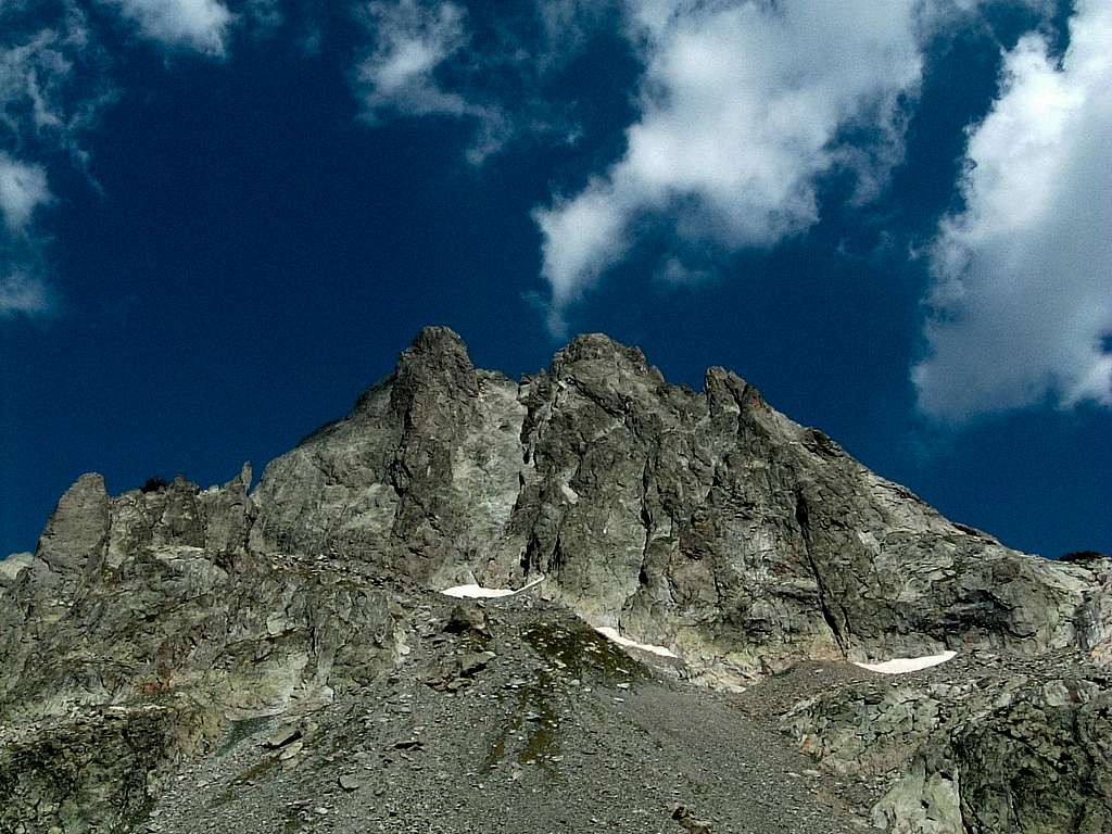
Cima di Nasta 3108 m
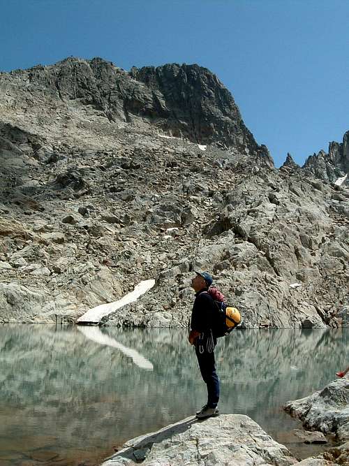
Cima di Nasta is an interesting rocky peak belonging to the Maritime Alps and situated in a secluded position between Colletto della Forchetta and Colle di Nasta. It’s a stately gneiss peak overlooking the RifugioRemondino with its impressive West Face and lined up along the same chain as Corno Stella. Cima di Nasta is formed by three main summits, lined up along a ridge running for about one hundred meters; the highest summit is the Central one. From this summit a pronounced ridge starts heading toward SSW and giving rise to a detached peak - the SW Uja di Nasta - while from the West summit another pronounced ridge starts heading towards NW and giving rise to an other detached peak – the NW Uja di Nasta -. Cima di Nasta has a veryeasy “Normal Route”, starting from the Rifugio Remondino and reaching the magnificent Lago di Nasta m 2800, one of the highest lakes in the Maritime Alps. From the lake the route rises towards North, heading to a gully. An easy scramble is getting to the Central summit, the highest.
The most important face to climb is the shady West Face, a 250-300 meters high face rising in front of Rifugio Remondino. This wall has a plenty of classic and modern climbs on high quality gneiss. An obvious ridge, starting from the West summit, runs in the middle of the West Face. Along this ridge is rising maybe the best classic route of Cima di Nasta, named Spigolo Vernet (Vernet Ridge), one of most frequently climbed routes in Maritime Alps. Cima di Nasta reputation is due to its interesting climbing routes, its fine milieu and its closeness to the hut.
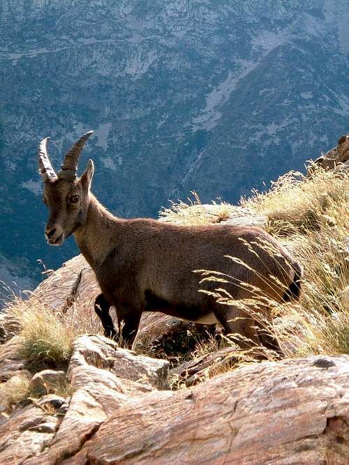
An Ibex kid in Maritime Alps
Cima di Nasta è un'elegante vetta rocciosa situata nelle Alpi Marittime, in posizione isolata tra il Colletto della Forchetta e il Colle di Nasta; è una maestoso montagna di gneiss che domina il rifugio Remondino con la sua imponente parete ovest, allineata lungo la stessa catena del Corno Stella. La Cima di Nasta è formata da tre sommità principali, allineate lungo una cresta lunga circa un centinaio di metri; la vetta più alta è quella centrale. Da questa sommità una cresta pronunciata si dirige verso SSW dando origine a una torre staccata - Uja di Nasta Sud-Ovest- mentre dalla sommità occidentale un'altra cresta pronunciata si dirige verso NW dando origine ad un' altra torre staccata - Uja di Nasta Nord-Ovest -. La Cima di Nasta presenta una Via Normale molto semplice, con partenza dal Rifugio Remondino, raggiungendo il magnifico Lago Nasta 2800 m, uno dei laghi più alti delle Alpi Marittime. Dal lago il percorso sale verso nord, dirigendosi verso un burrone. Una facile arrampicata conduce alla vetta centrale, la più elevata. La parete più importante da scalare è l'ombrosa Parete Ovest, alta circa 250-300 metri, situata proprio di fronte al Rifugio Remondino. Questa parete presenta diverse salite classiche e moderne su gneiss di alta qualità. Un marcato spigolo, a partire dalla sommità occidentale, corre nel mezzo della parete Ovest. Lungo questa dorsale sale forse la migliore via classica della Cima di Nasta, chiamata Spigolo Vernet (Vernet Ridge), una delle vie più frequentemente scalate delle Alpi Marittime. La reputazione di Cima di Nasta è dovuta alle sue interessanti vie di arrampicata, all' ambiente selvaggio e alla vicinanza al rifugio.
History
The first ascent to the top (1878, september, the twenty-seventh) was realized by the british D.W. Freshfield and his guide F. Devouassoud along North Side.
Getting There
Road access
From Turin (85 km.) or Genova (145 km.) follow the autoroute Torino-Savona as far as Cuneo exit. From Cuneo follow the road to Borgo San Dalmazzo, driving up on Valle Gesso and reaching Terme di Valdieri (35 km. from Cuneo). From here a narrow road, at least unpaved, leads up a lateral valley named Vallone della Casa; follow it as far as Pian della Casa, where the road ends (mt. 1743, parking). 6,5 km. from Terme di Valdieri.
Accesso stradale
Da Torino (85 km.) oppure da Genova (145 km.) Seguire l'autostrada Torino-Savona fino all'uscita di Cuneo. Da Cuneo si segue la strada per Borgo San Dalmazzo, risalendo la Valle Gesso e raggiungendo le Terme di Valdieri (35 km. Da Cuneo). Da qui una stradina sterrata risale un vallone laterale denominato Vallone della Casa; seguirla fino a Pian della Casa, dove termina la strada (1743 m, parcheggio). 6,5 km. dalle Terme di Valdieri.
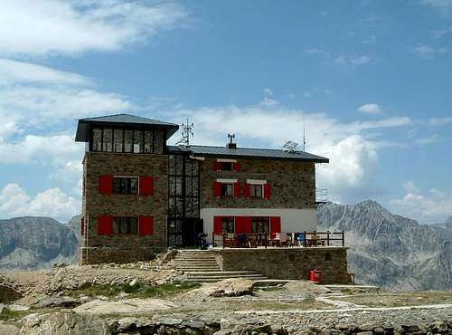
Owner: CAI Club Alpino Italiano Sez. Cuneo Size: 46 people + 12 in the winter shelter Open: from June to September
Approach
From Pian della Casa 1743 m – parking lot - a good path follows the Vallone di Assedras leading to the hut in about 2 hours from the parking. The hut is a natural “belvedere” over the Argentera Massif and a strategic important hut for all the ascents to Cima Nasta, Argentera Normal Route and several treks inside the Argentera and Nasta groups, offering meals and beds.
Avvicinamento
Da Pian della Casa 1743 m - parcheggio - un buon sentiero segue il Vallone di Assedras e sale al rifugio in circa 2 ore. Il rifugio è un belvedere naturale sul massiccio dell'Argentera e un punto strategico per tutte le scalate su Cima Nasta, per la Via normale dell'Argentera e per numerose escursioni all'interno dei gruppi dell'Argentera e della Nasta.
Cima di Nasta Normal Routes
Cima di Nasta has three Normal Routes and all of them are easy; the North one is the route of the first summiters. This team in 1878 realized the crossing of the peak, rising up the North Side and going down along the SE Ridge. Another Normal Route follows the South gully (V. de Cessole – J.B and J. Plent in 1898).
North Side F, 180 m. The route is starting from Colle di Nasta 2939 m, situated between Cima di Nasta and Cima Paganini (1,30 hour from Remondino Hut). SE Ridge PD, 160 m. This route is starting from Colle della Forchetta 2950 m (1,30 hour from Remondino Hut). South Gully F, 250 m. The easier route and the most frequented (2 hours from Remondino Hut).
La Cima di Nasta ha tre Vie Normali tutte facili; quella a Nord è il percorso dei primi saltori. Questa cordata nel 1878 realizzò la traversata della montagna, salendo lungo il versante Nord e scendendo lungo la cresta Sud-Est. Un'altra Via Normale sale in vetta lungo il canalone Sud (V. de Cessole - J.B e J. Plent nel 1898).
Versante Nord F, 180 m. Il percorso parte dal Colle di Nasta 2939 m, situato tra Cima di Nasta e Cima Paganini (1,30 ora dal Rifugio Remondino). Cresta SE PD, 160 m. Questo percorso parte dal Colle della Forchetta 2950 m (1,30 ora dal Rifugio Remondino). Canalone Sud F, 250 m. Il percorso più facile e più frequentato (2 ore dal Rifugio Remondino).
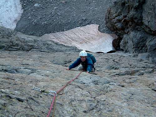
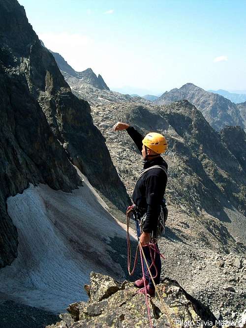
"Mai dire io" report - West Face
"Mai dire io" - West face
Summit altitude: m. 3108 Difficulty: TD inf., F6a, F5b+ obbl. Length: 320 m. Equipment: spaced bolts, friends useful First ascent: Beppe Viberti and Bruno Ronzini in 1999 summer Hut: Rifugio Remondino m. 2430 in upper Assedras Valley
A very fine modern route on excellent gneiss, requiring a bit of experience in placing running protections. The route is dedicated to Gabriele Beuchod.
"Mai dire io" report
From the hut rise along steep slopes towards West Face, heading to an obvious slabs’zone, situated in the left-hand sides of the face, near a groove-gully. The snow sometimes remains also in late summer. Starting point is W face highest point, nearby a zone of light slabs, cut by a thin crack, and 20 mt. on the left-hand side of “Lupo Alberto”, another easier modern route.
L1 – Climb the smooth sloping slabs to the upper ledge. 6a, 40 mt. L2 – From the belay climb up straightly the steep wall, heads to left and climb another steep wall, then a slab and a little wall. 6a, 45 mt. L3 – Climb straight a steep slab with good holds. 5b, 50 mt. L4–L5 Two pitches 45 mt. long, always straightly along another slab. 5b L6 – Another slab is leading lightly towards left to a prominence. Belay after climbing the prominence. 5a, 30 mt. L7 – Climb up straightly, then slants to left heading towards some steep corners cutted by some cracks, climb the corners reaching a new slab and belay on a ledge near a little edge. 5b, 50 mt. L8 – Climb easy slantways towards right, reaching a new belay. 3c, 40 mt. L9 – Traverse right. 4a. 40 mt. L10 – Climb a steep wall on the right-hand side of an obvious crack in the shape of a Z. An easy ridge is leading to the summit. 3a, 100 mt. Summit cross.
Descent: along S Side Normal Route, reaching Nasta Lake and from here Remondino Hut. (1,15 hours from the summit to the hut).
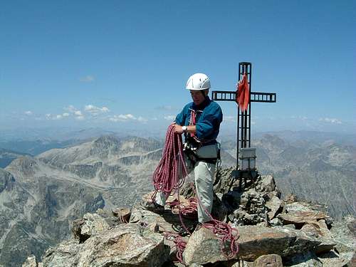
Cima di Nasta
"Mai dire io" - Parete Ovest
Altitudine vetta: m. 3108 Difficoltà: TD inf., F6a, F5b + obbl. Lunghezza: 320 m. Attrezzatura: spit distanziati, utili i friends Primi salitori: Beppe Viberti e Bruno Ronzini nell'estate 1999 Rifugio: Rifugio Remondino m. 2430 nell'alta Valle di Assedras
Una via moderna molto bella su ottimo gneiss, che richiede un po' di esperienza nel posizionamento di protezioni veloci. La via è dedicata a Gabriele Beuchod.
Mai dire io Route starting slabsCima di Nasta summit cross and book
Relazione
Dal rifugio si sale per ripidi pendii verso la parete ovest, dirigendosi verso un'evidente zona placche, situata nel settore sinistro della parete, in prossimità di un canalone. La neve a volte permane anche a fine estate. L'attacco è situato nel punto più alto della parete O, in prossimità di una zona di placche intersecata da una sottile fessura, e 20 metri sulla sinistra della via “Lupo Alberto”, altra via moderna più facile.
L1 - Risalire le placche lisce e inclinate fino alla cengia superiore. 6a, 40 m L2 - Dalla sosta si risale in linea retta la ripida parete, si punta a sinistra e si sale un'altra ripida parete, poi una placca e un muretto. 6a, 45 m L3 - Direttamente su placca ripida con buoni appigli. 5b, 50 m L4 – L5 Due tiri lunghi 45 m, sempre verticalmente lungo un'altra placca. 5b L6 - Un'ennesima placca conduce leggermente verso sinistra fino a una prominenza. Sosta dopo aver scalato il risalto. 5a, 30 mt. L7 - Sempre direttamente, poi in obliquo a sinistra in direzione di alcuni diedri verticali fessurati, salire i diedri poi una nuova placca e sostare su una cengia in prossimità di uno spigoletto. 5b, 50 m L8 - Arrampicare facilmente verso destra, raggiungendo una nuova sosta. 3c, 40 m L9 - Traversa a destra. 4a. 40 m - L10 - Risalire una ripida parete sul lato destro di un'evidente fessura a forma di Z. Una facile cresta porta in vetta. 3a, 100 m. Croce.
Discesa: per Via Normale versante S, raggiungendo il Lago Nasta e da qui il Rifugio Remondino. (Ore 1,15 dalla vetta al rifugio).
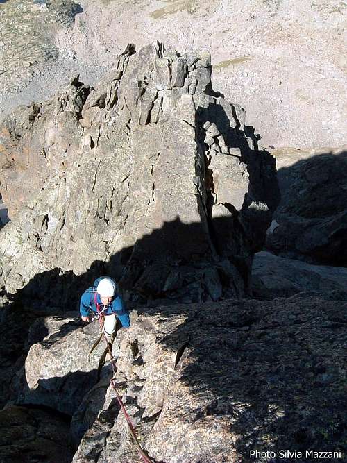
A slab on the route "Mai Dire Io"
Climbing on Cima di Nasta
Cima Nasta W Face from T. Querzola
L7 – Climb up straightly, then slants to left heading towards some steep corners cutted by some cracks, climb the corners reaching a new slab and belay on a ledge near a little edge. 5b, 50 mt. L8 – Climb easy slantways towards right, reaching a new belay. 3c, 40 mt. L9 – Traverse right. 4a. 40 mt. L10 – Climb a steep wall on the right-hand side of an obvious crack in the shape of a Z. An easy ridge is leading to the summit. 3a, 100 mt. Summit cross. Descent: along S Side Normal Route, reaching Nasta Lake and from here Remondino Hut. (1,15 hours from the summit to the hut).
There are not special restrictions in climbing, hiking and mountaineering. Anyhow Cima di Nasta is located inside Parco delle Alpi Marittime, established in 1980, so some basic rules concerning environmental respect are essential. Fires are forbidden and free camping is not allowed. To bivy is authorized only at more than 1 hour’s walk from the park's boundaries or from the access roads. The whole fauna and flora is protected.
Non ci sono particolari restrizioni per l'arrampicata, l'escursionismo e l'alpinismo. Cima di Nasta si trova comunque all'interno del Parco delle Alpi Marittime, istituito nel 1980, quindi alcune regole di base in materia di rispetto ambientale sono fondamentali. I fuochi sono vietati e il campeggio libero non è consentito. Il bivacco è autorizzato solo a più di 1 ora di cammino dai confini del parco o dalle strade di accesso. La fauna e la flora sono protette.
Climate
The name of Maritime Alps - to which it belongs Cima di Nasta - must not deceive you: the range is located nearby the sea, but the climate is alpine with cold winters and many snowfalls. The best season to climb Cima di Nasta W Face, a shady and cold environment, is the summertime.
Il nome Alpi Marittime - a cui appartiene Cima di Nasta - non deve trarre in inganno: la catena si trova vicino al mare, ma il clima è alpino con inverni freddi e copiose nevicate. La stagione migliore per scalare la parete Ovest della Cima di Nasta, un ambiente ombroso e fresco, è l'estate.
Flora
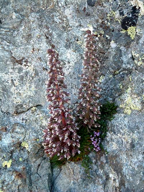
A rare shot of Saxifraga Florulenta
"SAXIFRAGA FLORULENTA MORETTI", AN ENDEMIC RARITY
Many rare and endemic species live in Maritime Alps, due to the group’s geographic position, under the influence of sea in Southern side and with a typical alpine climate in Northern side and in the highest zones. Also the action of the ancient glaciers, the variety of the rocks and the human activities have contributed to the peculiarity of the mountain group. No other place in the alpine chain is so rich in animal and vegetable species. You can find artic species as Ranunculus Glacialis and mediterranean species as Lavandula Angustifolia and Juniperus Phoenicea. The most important endemic specie is the Saxifraga Florulenta – Family Saxifragaceae, Genus Saxifraga - a plant which lives only in some particular environments at an altitude between 1800 and 3000 meters. Its English name is “The Ancient King”, while italian name is “Sassifraga dell’Argentera”. Clarence Bicknell, a famous British botanic, also called it “Maritime Alps glory”. This rare incredible plant can live till 50 years and its peculiarity is due to the fact that it flourishes only a time, just before dying!
"SAXIFRAGA FLORULENTA MORETTI", UNA RARITÀ ENDEMICA
Nelle Alpi Marittime vicono molte specie rare endemiche, per la particolare posizione geografica del gruppo, che si trova sotto l'influenza marina nella parte meridionale, mentre nella parte settentrionale e nelle zone più elevate presenta un tipico clima alpino. Anche l'azione degli antichi ghiacciai, la varietà delle rocce e le attività umane hanno contribuito alla peculiarità del gruppo montuoso. Nessun altro posto nella catena alpina è così ricco di specie animali e vegetali. Si possono trovare specie artiche come Ranunculus Glacialis e specie mediterranee come Lavandula Angustifolia e Juniperus Phoenicea. La specie endemica più importante è la Saxifraga Florulenta - Famiglia Saxifragaceae, Genere Saxifraga - una pianta che vive solo in alcuni ambienti particolari ad un'altitudine compresa tra 1800 e 3000 metri. Il nome inglese è "The Ancient King", mentre il nome italiano è "Sassifraga dell'Argentera". Clarence Bicknell, un famoso botanico britannico, lo chiamò anche "Gloria delle Alpi Marittime". Questa rara e incredibile pianta può vivere fino a 50 anni e la sua peculiarità è dovuta al fatto che fiorisce solo una volta, poco prima di morire!
“Alpi Marittime Vol. II” by Euro Montagna-Lorenzo Montaldo-Francesco Salesi – Guide dei Monti d’Italia CAI-TCI “Le Alpi del mare" – Scalate moderne nei massicci dell’Argentera e del Mongioie” by Flaviano Bessone – Idee Verticali Edizioni
Parents refers to a larger category under which an object falls. For example, theAconcagua mountain page has the 'Aconcagua Group' and the 'Seven Summits' asparents and is a parent itself to many routes, photos, and Trip Reports.

 8049 Hits
 86.85% Score
 23 Votes