
-
 6216 Hits
-
 85.87% Score
-
 21 Votes
|
|
Mountain/Rock |
|---|---|
|
|
46.20109°N / 10.70775°E |
|
|
Trentino |
|
|
Mountaineering, Trad Climbing, Sport Climbing |
|
|
Summer |
|
|
8711 ft / 2655 m |
|
|
What's new on this page?
PAGINA COMPLETA DI TRADUZIONE IN LINGUA ITALIANA - THE ITALIAN TRANSLATION ADDED TO THE PAGE (2023, May)
Overview
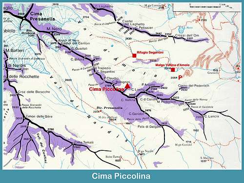
Cima Piccolina 2655 m
The beautiful Val d'Amola has been enhanced by the achievement of some interesting climbing routes. It is the case of Cima Piccolina, a fine spire culminating in a tiny summit surrounded by beautiful granite peaks. As its name suggests - Piccolina means "tiny" - Cima Piccolina is a minor summit, anyhow spectacular, belonging to the South-Eastern sector of the Presanella Group and located in Val d'Amola, not far from Rifugio Segantini, on a secondary ridge that branches off from the long main ridge dividing the Val di Nardis from the Val d'Amola. The variety of climbs offered by this valley is remarkable and makes it one of the most interesting venues of the Presanella group from the point of view of rock climbing. They range from the classic climbs on Campanile di San Giusto to the East wall of Cima Presanella and to the modern routes on Cima Piccolina and Corno di Pedertic, excellent introduction to the particular environment of this area.
The interest of Cima Piccolina is due both to the wonderful alpine setting and its fine and compact East wall, made in a good quality of rock, the "tonalite", the typical rock of Presanella Group. The "tonalite" is an intrusive magmatic rock having a composition similar to granites and granodiorites. This kind of rock was named in this way by the German geologist Gerhard vom Rath, who found it for the first time in the year 1857 on the Tonale Pass. There are different routes on the East wall, both trad and moderne. In this page it's related a moderne one, the route "Akku", which is a very advisable climb.
Italian version
La bellissima Val d'Amola è stata valorizzata con la realizzazione di alcune interessanti vie di arrampicata. È il caso di Cima Piccolina, una bella guglia che culmina in una piccola vetta circondata da splendide montagne di granito. Come suggerisce il nome, Cima Piccolina è una vetta minore, ma comunque spettacolare, appartenente al settore sud-orientale del Gruppo della Presanella e situata in Val d'Amola, non lontano dal Rifugio Segantini, su una dorsale secondaria che si dirama dalla lunga dorsale principale che divide la Val di Nardis dalla Val d'Amola. La varietà di scalate offerte da quest'ultima valle è notevole e per quanto riguarda l'arrampicata su roccia ne fa una delle zone più interessanti del gruppo della Presanella. Si va dalle classiche scalate del Campanile di San Giusto fino alla parete Est di Cima Presanella e ai moderni percorsi di Cima Piccolina, ottima introduzione al particolare ambiente di questa zona.
.


L'interesse di Cima Piccolina è dovuto sia alla meravigliosa cornice alpina che alla sua bella e compatta parete Est con roccia di buona qualità, la "tonalite", la tipica roccia del Gruppo Presanella. La "tonalite" è una roccia magmatica intrusiva con una composizione simile ai graniti e ai granodioriti. Questo tipo di roccia fu così chiamato dal geologo tedesco Gerhard vom Rath che la trovò per la prima volta nell'anno 1857 sul Passo del Tonale. Sulla parete Est sono presenti diverse vie, sia trad che moderne. Qui è relazionata una delle moderne, la via "Akku", che è una salita del tutto consigliabile.
Getting There
Road access
The road access is from Val Rendena, where a turn-off road allows to reach by car up to more than 2000 m of altitude (Vallina d'Amola).

Getting to Val Rendena
Coming from Autobrennero exit Trento and take the road to Riva del Garda, reaching the village Le Sarche. Here continue straight toward Tione di Trento. In Tione turn to right and take the SS 239 Val Rendena route to Pinzolo. Pass Pinzolo and drive a few kilometers towards Madonna di Campiglio. After the village of Carisolo, leave the main road and turn to left, taking a narrow road rising along Val Nambrone towards Laghi di Cornisello. After driving about 9 km on this road with several hairpins we reach a fork. The main road leads to Laghi di Cornisello, we instead turn to left (Rif. Segantini signposts), omit the path n. 211 on our right hand side and continue driving for about 1 km, leaving the car in the parking lot before the bridge over the river Sarca that leads to the Malga Vallina d'Amola (2020 m).
Accesso stradale
L'accesso stradale è dalla Val Rendena, dove una deviazione permette di salire in auto fino a oltre 2000 m di quota (Vallina d'Amola).
Come arrivare in Val Rendena
Provenendo da Autobrennero uscire a Trento e prendere la strada per Riva del Garda, raggiungendo la frazione Le Sarche. Qui proseguire dritto verso Tione di Trento. A Tione girare a destra e prendere la SS 239 della Val Rendena fino a Pinzolo. Superare Pinzolo e proseguire per pochi chilometri in direzione Madonna di Campiglio. Dopo l'abitato di Carisolo si lascia la strada principale e si svolta a sinistra, imboccando una stradina che sale lungo la Val Nambrone verso i Laghi di Cornisello. Dopo aver percorso circa 9 km su questa strada con diversi tornanti arriviamo ad un bivio. La strada principale porta ai Laghi di Cornisello, noi invece svoltiamo a sinistra (segnavia Rif. Segantini), tralasciamo il sentiero n. 211 sulla nostra destra e proseguiamo per circa 1 km, lasciando l'auto nel parcheggio prima del ponte sul fiume Sarca che porta alla Malga Vallina d'Amola (2020 m).
Cima Piccolina - Via Akku report
Akku report (French scale)
Summit altitude: 2655 m
Difficulty: 6a+ max - French scale
Climbing length: 180 m
Equipment: equipped belays, some bolts along the pitches to be integrated with quick protections
Exposure: East
Starting point: Parking lot in Vallina d'Amola
First ascent: Davide Ortolani and Alessandro Botteri 14-9-2010
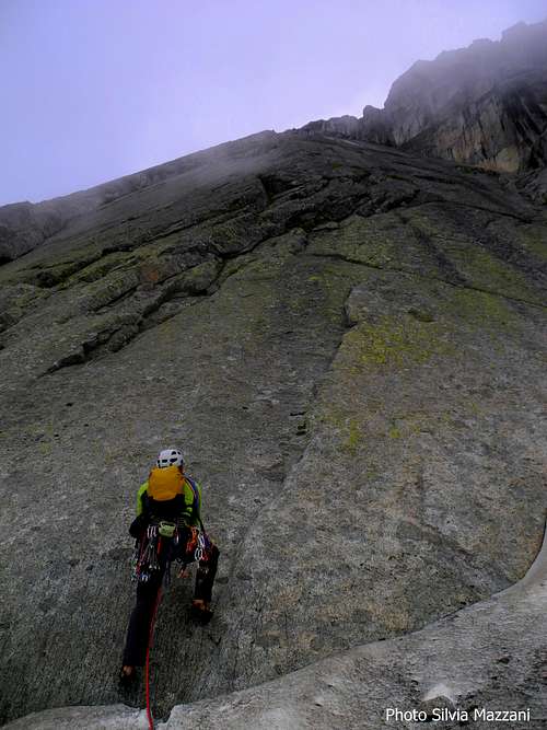
Excellent route which requires a good level and alternates compact slabs and dihedral-cracks. Spaced bolts. At first it follows a shallow corner on the right hand of the compact East wall. The rock is a kind of granite named "tonalite" and the route is quite advisable, in an alpine setting of great beauty.
Start of the route Akku |
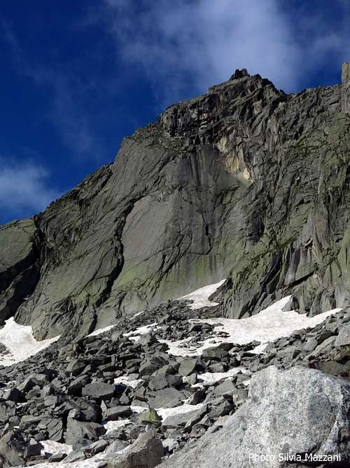
Cima Piccolina |
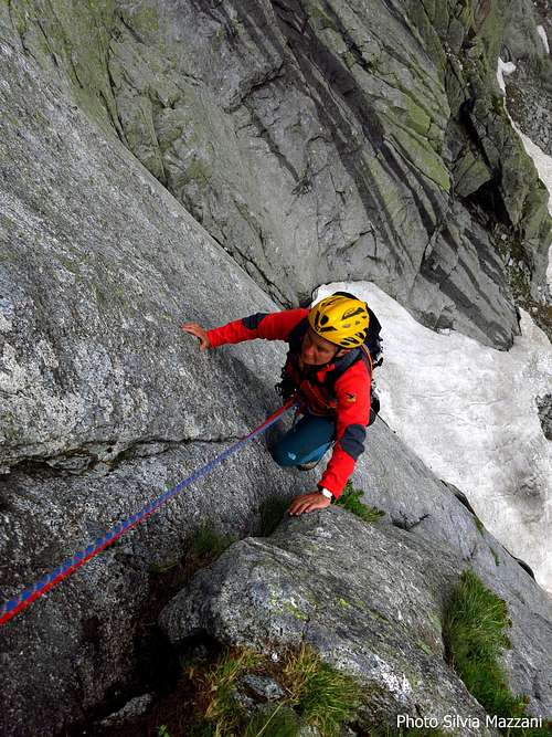
Akku first pitch |
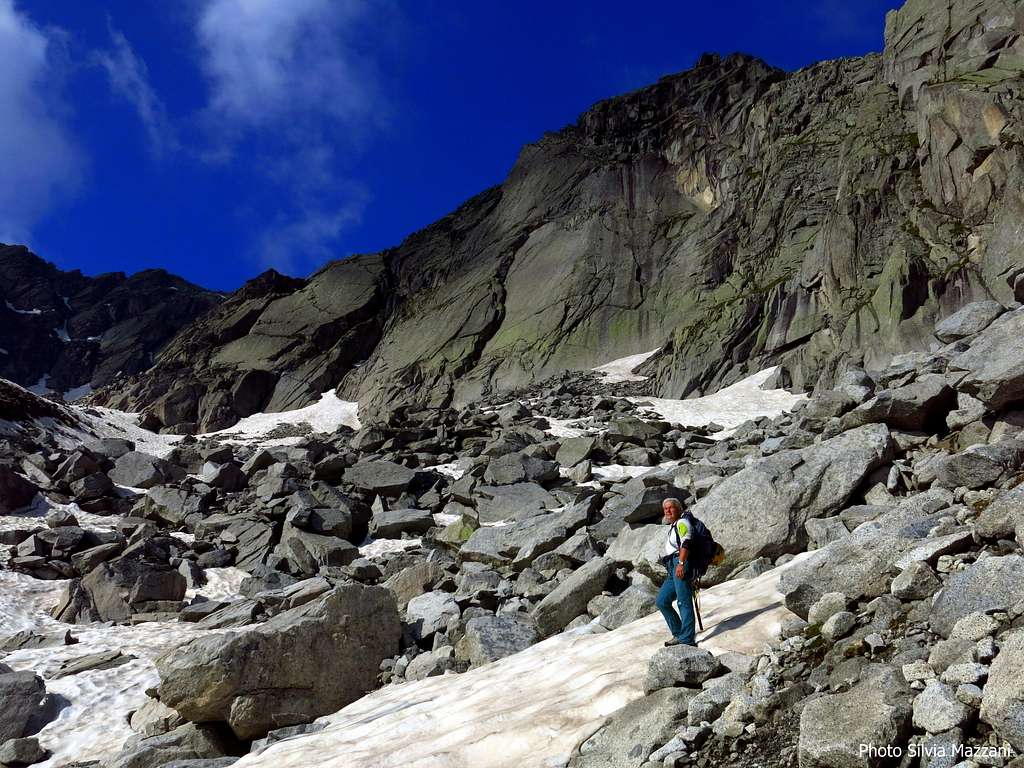
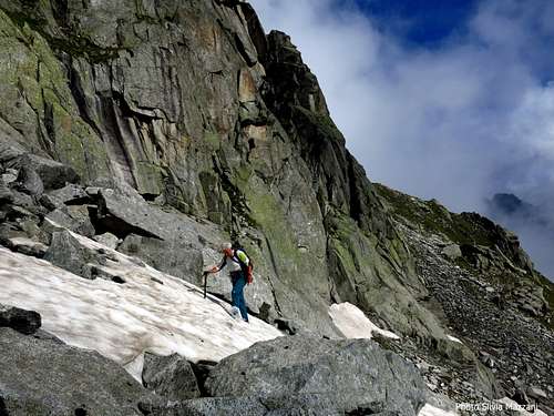
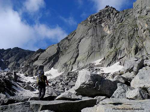
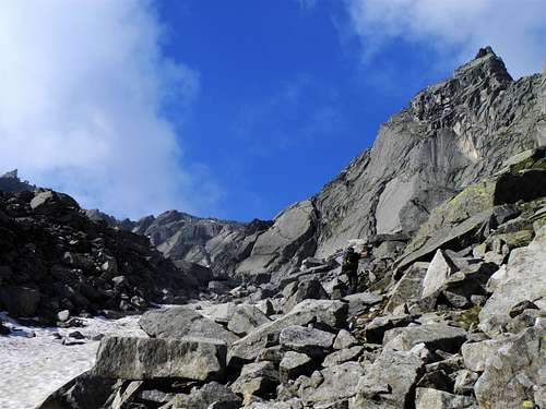
Walking approach: from the parking lot there are two possibilities (anyhow the two paths soon join above): take immediately the left path (without crossing the stream) - mainly horizontal - or alternatively cross the stream on the bridge, follow the wide track above Malga Vallina d'Amola and then cross the river again taking the path SAT 211 b "Michele Mattasoglio". After an almost horizontal stretch, the path begins to rise in the middle of the valley. To the left it's already visible Cima Piccolina. Two cairns along the path indicate the point where it must be abandoned to exit to the left, cross the river and climb up the steep grassy and sparse moraine slope.
(cairns, snow at the beginning of the season). At the summit of the slope we keep the right to reach the wall with snowfields at the base also at advanced season.
L1 - The starting point is below a shallow corner. Climb it, then slanting right reach a dihedral-crack system. Follow it to reach the belay, 5c, then 4c, 45 m. (4 bolts)
L2 - From the belay traverse to the left around an edge, then climb directly the upper compact slabs. At the end start to climb sharply to the right with some delicate steps to reach the belay, 6a+, 40 m (6 bolts).


L3 - Directly above the stance for a few meters, then traverse left and keep the slabs, climb it and belay at the base of easier rocks, 6a, 45 m (6 bolts).
L4 - Easier rocks lead directly to the next belay, 3c, 25 m.
L5 - Continue reaching the final wall, that is climbed along a short edge and the ending slab to the last belay, 4b, 25 m. From the fifth belay - which marks the end of the route Akku - head to right and scramble up on easy rock for about 100 meters to reach the fine tiny summit of Cima Piccolina.


Descent - from the summit return downclimbing to the last belay. From here five abseil to the bottom of the wall
Italian version
Bella e consigliabile via in ambiente alpino di grande bellezza. Richiede un discreto livello e alterna placche compatte e fessure. Chiodatura distanziata. All'inizio segue un diedro poco profondo nel settore destro della compatta parete Est. La roccia è un tipo di granito chiamato "tonalite".
Avvicinamento:.
Dal parcheggio ci sono due possibilità (comunque i due percorsi si uniscono dopo poco): prendere immediatamente il sentiero a sinistra (senza attraversare il torrente) - principalmente in piano - o in alternativa attraversare il torrente sul ponte, seguire l'ampia traccia sopra Malga Vallina d'Amola e poi attraversare nuovamente il fiume prendendo il sentiero SAT 211 b "Michele Mattasoglio". Dopo un tratto quasi orizzontale, il sentiero inizia a salire nel mezzo della valle. A sinistra Cima Piccolina è già visibile. Due ometti lungo il sentiero indicano il punto in cui questo deve essere abbandonato per uscirne a sinistra, attraversare il fiume e risalire il ripido pendio morenico ed erboso (ometti, neve a inizio stagione). Arrivati sotto la parete teniamo la destra per raggiungere la base della parete (possibili nevai alla base anche in stagione inoltrata).
L1 - L'attacco è sotto un diedro svasato. Risalire il diedro, quindi in obliquo a destra raggiungere un sistema di diedri e fessure che si segue fino alla sosta, 5c, quindi 4c, 45 m. (4 fix)
L2 - Dalla sosta traversare a sinistra attorno a uno spigolo, quindi salire direttamente le placche compatte al di sopra. Alla fine iniziare a traversare decisamente a destra con alcuni passaggi delicati per raggiungere la sosta, 6a +, 40 m (6 fix).
L3 - Direttamente sopra la sosta per alcuni metri, quindi traversare a sinistra per prendere le placche, scalarle e sostare alla base di rocce più facili, 6a, 45 m (6 fix).
L4 - Per terreno facile direttamente alla sosta successiva, 3c, 25 m.
L5 - Continuare e raggiungere il muro finale, che si sale lungo un breve spigolo e una placca finale fino all'ultima sosta, 4b, 25 m
Dalla quinta sosta - che segna il termine della via Akku - dirigersi a destra e arrampicare su facili rocce per circa un centinaio di metri per raggiungere la piccola vetta della Cima Piccolina (ometto).
Discesa - dalla cima disarrampicare fino all'ultima sosta. Da qui con cinque corde doppie attrezzate alla base della parete
Essential gear
Rope 2 x 60m, helmet, a set of friends
Other routes on Cima Piccolina
- Via Maffei
- Via Sacchi
- Mille splendidi soli
- Antonietta
- Vive le rock
- ME con TEK e TEK con MEK
- Per far contento Remo
See more info here: Val d'Amola Cima Piccolina
Red Tape
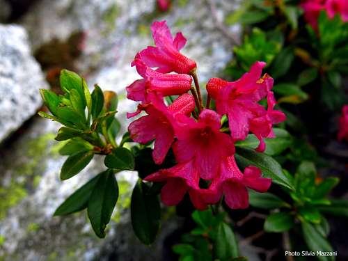
Alpenrose in Val d'Amola
There are no particular restriction in climbing and hiking. Cima Piccolina is located within Parco Naturale Adamello Brenta, the largest protected area in Trentino, established in the year 1967. It's located in Western Trentino and with its 620.51 square kilometers includes the mountain groups of Adamello, Presanella separated from the Brenta Dolomites by Val Rendena.
Non ci sono particolari restrizioni nell'arrampicata e nell'escursionismo. Cima Piccolina si trova all'interno del Parco Naturale Adamello Brenta, la più grande area protetta del Trentino, istituita nel 1967. Si trova nel Trentino occidentale e con i suoi 620,51 kmq comprende i gruppi montuosi dell'Adamello, della Presanella separati dalle Dolomiti di Brenta dalla Val Rendena.
When to Climb
Best period to climb goes from middle June to middle September
Il periodo migliore per arrampicare va da metà giugno a metà settembre
Where to stay
Several possibilities of accomodation in Val Rendena.
Ci sono molte possibilità di alloggio in Val Rendena.
Huts:
Rifugio Nambrone
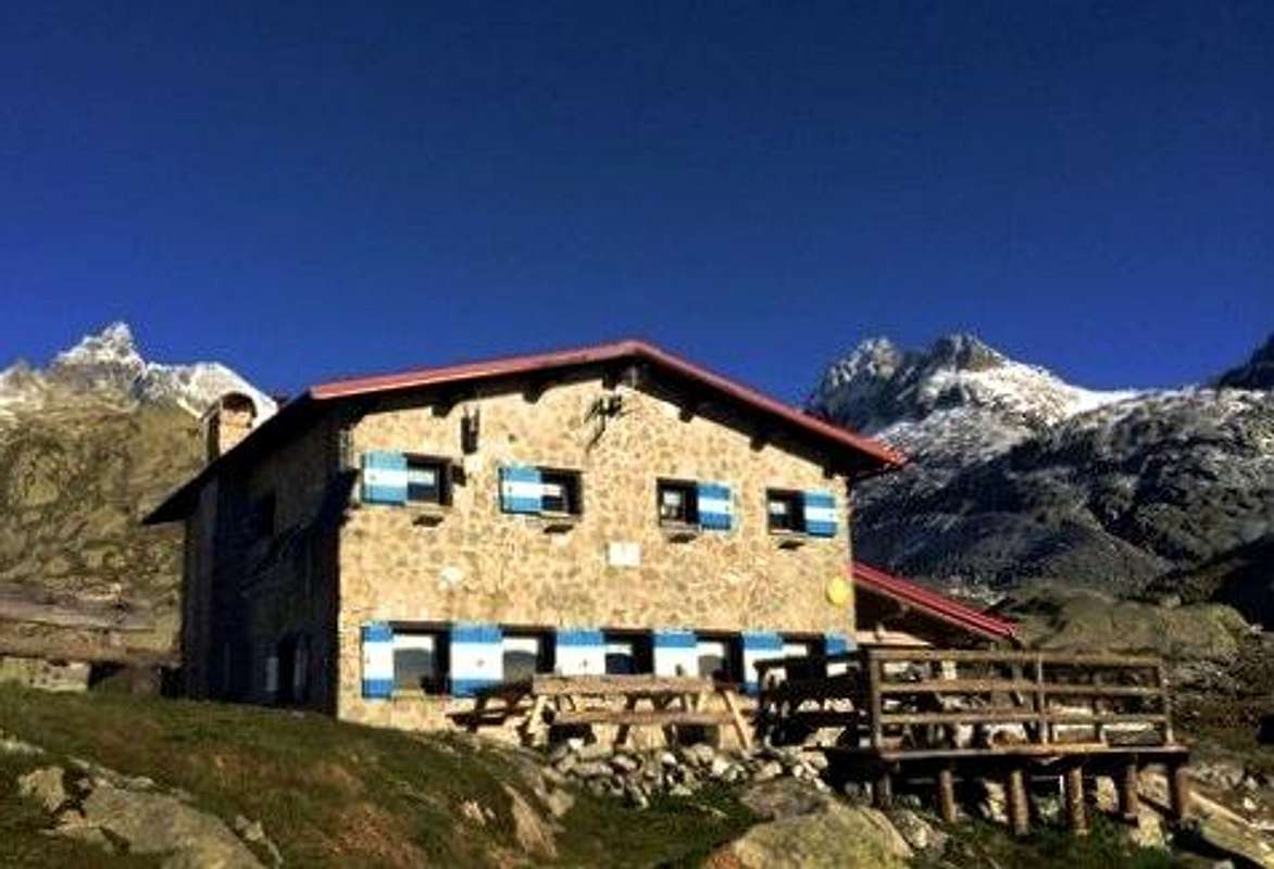
Rifugio Segantini
Meteo
METEO TRENTINO
DOLOMITI METEO - TRENTINO
Guidebooks and maps
"Presanella" - Guida dei Monti d'Italia CAI-TCI - Dante Ongari, 1978
"110 Itinerari Alpinistici del Gruppo della Presanella" - Urbano Dell'Eva, Edizioni Manfrini 1985
Maps:
"Adamello - Presanella" - Tabacco scala 1:25000