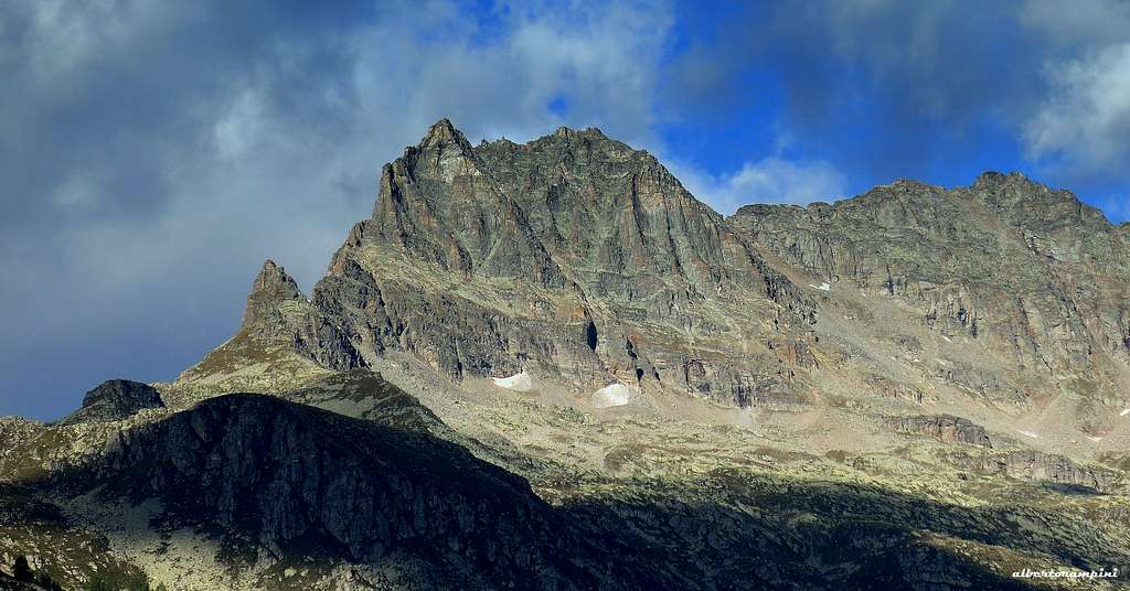
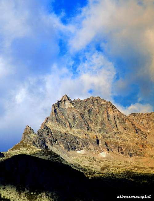
The Gran Paradiso Group, largely known in reason of its Northern high mountains covered by glaciers, kingdom of classic old fashion mixed mountaineering routes, shows in its Southern side another wonderful kingdom, made of steep granite walls and beautiful hard rock climbs, both classic and modern. The complex and very interesting rocky summit of Courmaon lies inside this chain, Punta Fourà Sub-Group, in the middle of the beautiful basin overlooking the village of Ceresole Reale and its homonymous great artificial lake. The mountain ridges create three main sides: a rocky and superbNorth-East face, overlooking the Vallone del Roc, well visible also from Orco Valley, another rocky and steep wall facing South, rising from the Boiret basin, and a scree-sloping West side. Courmaon shows a triangular rocky structure build by several shape spurs, separated by some scree-gullies. Courmaon has an important mountaineering tradition; while the main walls of this sector of Gran Paradiso Group, as the ones lying in Piantonetto Valley and Orco Valley, had been explored later, since the early Forties a fine classic route had been realized on Courmaon: it’s the beautiful and classic East Ridge, climbed in the year 1942 by Giusto Gervasutti “il Fortissimo” and his pal Ettore Giraudo.
Cima del Courmaon
History
First summiter: the topographer Guarducci 1880, August 18th
After the South Spur ascent by the Giraudo brothers in the year 1940, it was the beautiful East ridge climbed by Giusto Gervasutti “il Fortissimo” and Ettore Giraudo in the year 1942 to draw the attention of the climbers on Courmaon. This route remained through several years the most famous route round about. Since the middle of the Sixties different protagonists of the Piedmont mountaineering, as Giancarlo Grassi, Ugo Manera and Gian Piero Motti started to explore the peak climbing new routes on the North-East spurs. The interest of the mountaineers started to take aim on the South wall in the year 1985, when Claudio Santunione climbed a new route on this face, followed by some other routes by the same Santunione with Manera the next year.
Getting There
Road access
Traditional house near Ceresole Reale
Alpe Loserai di Sopra
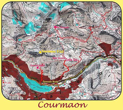
The starting point to climb Courmaon is Ceresole Reale m. 1613, a nice village lying near the great artificial Lake of Ceresole. Dam. Road access
- From Turin (Caselle international airport) reach Courgnè and Pont Canavese mt. 461; from here follow the road entering Valle dell’Orco, reaching Locana, Rosone, Noasca and Ceresole Reale m. 1613. (Km. 35 from Pont Canavese). - From Aosta take the Aosta-Torino motorway, exit Ivrea. From Ivrea follow the road towards Ciriè, reaching Pont Canavese. From here same access as the previous one.
Courmaon summit view toward Ciarforon and Tresenta
Walking approach to Courmaon
- Approach to South face – From Borgata Capoluogo in Ceresole follow the signpost “Sentiero Natura” toward the Grand Paradiso National Park “Casotto delle Cialme” (Cialme Shelter), getting to the shelter m. 2299 (1 and a half hour) and to the little Col of Boiret m. 2498, in view of Courmaon South face. Traverse towards left on a slope, getting the moraine which leads below S face left triangle.
-Approach to North-East face – From Borgata Broc in Ceresole follow the path towards Bivacco Giraudo, getting Colle Sià m. 2274. From Colle Sià reach the Alpe Loserai di sopra, carry on a bit, then leave the main path, rising on the scree-slopes to the basal pedestal (3,30 hours from Ceresole).
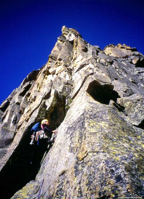
Via Gervasutti-Giraudo report
Via Gervasutti-Giraudo report
Summit altitude: 3162 m Difficulty: 6a (V+ and A0) Equipment: some pegs in place, some belays to be equipped, friends and nuts are useful Climbing length: 300 m Exposure: East First ascent: G. Gervasutti and E. Giraudo, 14-7-1942 Starting point: Ceresole Reale, Borgata Broc
Classic and advised route following a beautiful line. The rock is the tipical good gneiss of the Southern side of Gran Paradiso. The first part of the route is athletic and runs through the fine right edge of the triangle that characterizes Courmaon. The second one runs along the east ridge.
Approach
From the road rising to Ceresole Reale from the hamlet of Prese, just beyond the second hairpin, find to the right the road leading to the start of the GTA trail (signpost to Bivacco Giraudo). Follow the trail that reaches the grassy plateau of Cà Bianca (1942 m, hut). Continue, leaving the GTA trail, getting Colle Sià m. 2274. After crossing the col, in the valley of the Roc, locate and reach to the east the Alpe Loserai di Sopra 2312 m (2 hours from Ceresole). From the huts, find an ancient artifact for catching water, and follow it almost flat to get into the upper part of the Vallone del Roc, then head to the lowest point of the East crest, which is reached by climbing a steep scree (1.30 from Loserai di Sopra). Once reached the crest, bypass the first keeping the Vallone del Roc side the first prominences, then follow a ledge to the base of the obvious rocky triangle that characterizes the East side. Find a cairn at the base of the first corner.
L1 - From the ledge climb a dihedral-crack, then traverse right to the obvious cairn, climb up the corner and belay above on a terrace. IV+ and then V, 2 pegs, 40 m. L2 - Climb a few meters directly, then traverse right to get a second corner leading to a large terrace on the edge, IV+ then V, 2 pegs, 25 m. L3 - Continue on fine cracks heading to a characteristic yellow pillar, overcome the overhang and exit to the stance, V, V+ and 6a, 5 pegs, 35 m. L4 - Take the crack to the right of the stance, continue to the right towards a large overhanging block, climb it and where the wall starts overhanging pass to the right to take the corner leading again to the edge, 6a then V+ and V, 3 pegs, 45 m.
Cima del Courmaon
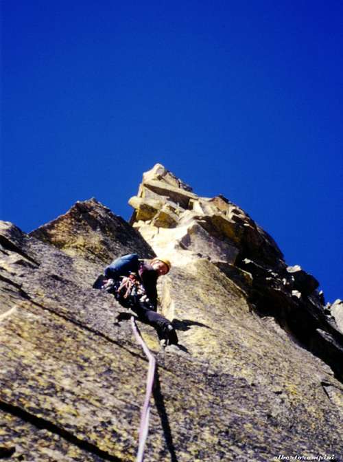
Gervasutti first pitch
Up Gervasutti NE ridge
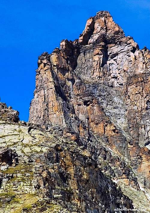
Detail of Courmaon NE side
L5 - Climb directly the yellow wall above, then follow the left side of the ridge, 6a, IV, 1 peg, 30 m.
L6 - Again on the left side along some steps to get the base of an obvious reddish wall cut by a crack, IV, III, 30 m.
L7 - Traverse left and reach a large terrace at the end of which there is a vertical corner, II, III, 50 m.
L8 - Climb the corner, then some steps lead to a ledge, V, IV, 4, 2 pegs, 35 m.
L9 - Head to right in the direction of a dihedral-crack and belay at the base, IV, III, 35 m.
L10 - Climb the dihedral-crack and to the left get the foresummit, V, IV, 35 m From the fore-summit 3155 m, cross the southern slope (Ceresole side), up to the main summit of the Courmaon (summit cairn).
Descent: from the summit reach the notch at 3077 m of altitude between Courmaon and Cuccagna. From the notch head towards Vallone del Roc, reaching a scree and a snow-gully. Scramble down the gully, then traverse towards right on pastures and rocky slopes to return to the Alpe Loserai di Sopra.
Courmaon summit ridge
Ciarforon seen from Courmaon
Gear: normal mountaineering gear, 10 quickdraws, nuts and friends series, 2 x 50 m ropes.
Other routes
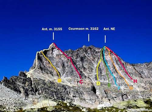
Courmaon North-East wall topo routes
A - Via Gervasutti-Giraudo TD-, 6a or V+ and A0 - Complete route description at the previous chapter
North-East Face
B – Via Dagna-Sebastian D, 4c/A1 C – Via Grassi-Re D-, 4c D – Var. Manera E – Via Grassi-Bottaro D+, 5a, 350 m. F – Via Manera-Delmastro D, 5a, 300 m. G – Diretta Manera TD-, 5a/A1, 350 m. U. Manera, C.Santunione 1975 – A few pegs in place, Friends, nuts and pegs are necessary to integrate H – Via Miglio PD, 3a, 300 m.
South Face
- Abbi Fede TD+, 6b, 6a obbl., 380 m.– V. Bertoglio – M. Oviglia 1999 - Equipped with bolts and pegs, equipped belays, friends and nuts are useful to integrate the protections in place
- Capriccio del Tempo TD, 5b/A1, 400 m. – R. and V. Sartore, S. Dalla Gasperina 1987 Trad climb, no pegs in place
- Masacu TD-, 5c/A0, 300 m. – U. Manera, C. Santunione 1986 – Trad climb, no pegs in place - Sacuma TD, 6a/A2, 300 m. – U. Manera, C. Santunione 1986 – Trad climb, no pegs in place
Descent from the summit: see the description at the previous chapter
Descent from the South face without summiting: it's possible to rappel on the route "Abbi Fede" (5 abseils) without summiting.
Red Tape
Courmaon is located inside the Gran Paradiso National Park (P.N.G.P.) , established in 1922, one of most important National Parks in Italy. Free camping is not allowed and fires are strictly forbidden. The whole fauna and flora are protected. Don’t disturb fauna and other mountaineering and hikers’ peacefulness with every kind of noise.
Where to stay
Different possibilities of accomodation in Ceresole Reale. There are not shelters or bivouac in the surroundings of Courmaon. Approach must be done directly from Ceresole Reale or eventually it's possible stay overnight in tent at the Alpe Loserai di Sopra.
When to climb
North-East face: best season goes from the end of June to middle September.
“Rock Paradise – Arrampicate classiche, moderne e sportive nelle valli delGran Paradiso” by Maurizio Oviglia – Collana Luoghi Verticali, Ed. Versante Sud
“Gran Paradiso – Parco Nazionale” by E. Andreis – R. Chabod –M.C. Santi - Collana Gudie dei Monti d’Italia C.A.I. TCI
Maps
"Il Parco Nazionale del Gran Paradiso"- Dalla Valle d'Aosta alla Valle di Ceresole 1:50.000 IGC-Istituto Geografico Centrale
"Gran Paradiso-La Grivola-Cogne" - Parco Nazionale del Gran Paradiso 1:25.000 IGC-Istituto Geografico Centrale
"Valsavarenche-Val di Rhemes-Valgrisenche" - Parco Nazionale del Gran Paradiso 1:25.000 IGC-Istituto Geografico Centrale
Parents refers to a larger category under which an object falls. For example, theAconcagua mountain page has the 'Aconcagua Group' and the 'Seven Summits' asparents and is a parent itself to many routes, photos, and Trip Reports.

 7095 Hits
 87.31% Score
 24 Votes