Original Plans
The initial planned itinerary was for Mark, Mike and I to head down to Ecuador for a shot at the Big 3 (Chimbo, Coto and Cayambe) with an acclimatization hike on Illiniza Norte. The plans were looking good when we hit Mts. Washington and Mansfield during January. Our hope was for 17 days in Ecuador starting May 28th.
Well as often happens in life, things changed. Mark took a job in Phoenix and found himself having to move cross-country from Long Island in order to start on July 1st. He would have to pay for the move out-of-pocket and wait for reimbursement. Given the circumstances he was out on Ecuador, and would likely have to pass on anything domestic as well.
Plans - Part Deux
Mike and I still needed to get in some extended time in the backcountry. We tossed around a few ideas/dates, but eventually committed to two weeks starting on 5/26/08 due to some training Mike needed to attend in Delaware starting on 6/9/08. Since Mike has a goal of the 50 U.S. highpoints before he is 50 we planned to warm up on Boundary Peak (NV), before heading into the Rock Creek area for Mts. Abbot and Starr. These peaks would serve as acclimatization before moving north into OR for attempts at Mt. Jefferson and North Sister. While spending a little more time driving than we cared for this itinerary would give us a nice collection of peaks over our two weeks.
Plans - Conditions Dictate Change
As time inched closer and closer to our trip we realized that Oregon may pose a problem. A very heavy snowpack and several late storms had us wondering about access and snow stability. The weekend before our departure an
avy on Hood convinced us that things really needed to shape up before even considering OR, without beta and a good forecast we would likely stay in CA. So now what to hit?
The lack of late season precip. and early season melt had us directed at the High Sierra. We were hoping to warm-up on Boundary Peak before heading into the Rock Creek area for a few peaks. Our next objective would be the Evolution Range for Darwin and Mendel via Lamarck Col. We hoped to finish on the South fork of Big Pine Creek for the Sill/Polemonium traverse via Scimitar Pass and possibly Middle Pal if time/conditions allowed.
However, Mother Nature had other plans! After several days of mixed precip., of varying accumulation, left the Sierra and Inyo-White Mtn. conditions as anyones' guess we were left to hope for the best and make do with what presented itself. We spent the afternoon of 5/25/08 devouring some fine Whoa Nelli Grub with a couple of beers and decided to head for Boundary Peak.
Day One - The Adventure Begins @ Boundary Peak
Much to our surprise after leaving Whoa Nellie we were able to drive to nearly 9,300' above the Queen Canyon Mine before encountering enough residual snow to halt our advance via 4x4. The overcast conditions were of concern, but there was minimal new precip. falling when we made camp and opted for sleep.
We awoke at 6 AM, with over 4" of fresh powder surrounding our campsite, with more accumulation falling. What to do now? We decide to attempt to dayhike the route, but would use snowshoes in anticipation of significant accumulation at the upper elevations.
As we prepared for departure two male hikers passed by about 30 minutes ahead of us. They indicate they are also going to attempt Boundary and hope to traverse to Montgomery. We didn't ask if they were planning for an overnight trip, but assumed so given the size of the packs they were carrying. Neither had snowshoes and only one was wearing gaiters.
Out of camp we follow their tracks for awhile. Visibility, which was less-than-ideal at the start of the day, continued to diminish. About an hour out of camp we found ourselves near 10,000'. We could no longer see their tracks nor the road to the Queen Canyon Saddle. Visibility was typically less than 20 yards and our snowshoe tracks were filling in quickly. Deciding not to continue into deteriorating conditions we chose to descend back to camp.
Upon returning to camp three other hikers passed by, without snowshoes. We tell them of the limited visibility and posthole conditions we were experiencing in snowshoes even before the Queen Canyon Saddle. Much to our surprise they opt to continue on towards the peak. We tear down camp and head to Mammoth Lakes for some beta and beer to decide what is next.
After checking the forecast at Looney Bean and searching the web for beta we are left to roll-the-dice. After a discussion with ranger Mike Johnson in Mammoth Lakes we opt to wait out the iffy forecast in the Rock Creek area. Our goal is an overnight trip where we hope to either A) climb Mt. Abbot via the NE couloir if the class 3 rock is clear of snow or B) climb the Hourglass couloir of Mt. Dade. After either peak we hope to make camp near Ruby Lake before attempting Mt. Starr via Mono Pass the following morning prior to descending to check the conditions and hopefully get some recent beta before deciding what is next.
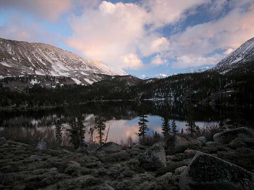
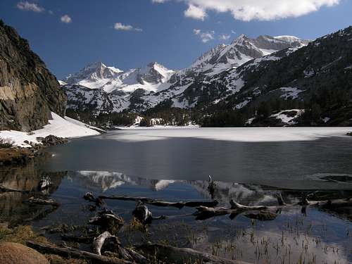
We drive to Rock Creek Lake and find the gate locked at the Pack Station. F'n lovely, another ~4 miles just got added to the overnighter even though the road appears clear. We make camp above the lake and are treated to our first good views of the trip. Abbot looks like it will have to wait for another day, so Dade is our objective for the following day.
![View of BCS, Dade and Abbot from Rock Creek Lake 5/26/08]() Bear Creek Spire, Mt. Dade and Mt. Abbot on 5/26/08 from Rock Creek Lake.
Bear Creek Spire, Mt. Dade and Mt. Abbot on 5/26/08 from Rock Creek Lake.Days 2 & 3 - Mother Nature Wins Again: Mt. Dade
The surprising absence of snow at 10,000', given our previous day's experience in the Inyo-White Mtns., leads us to enter without snowshoes. We do however hike the road to Mosquito Flat in trail runners while carrying our boots. Still can't believe the road is closed at the pack station, you could drive a damn low-rider to the TH. We dump our trail runners in a bear box and head down the trail, which is nearly 80% free of snow all the way to Hidden Lakes. From there we follow a well established boot track past Long Lake and up to the Treasure Lakes. Given our early arrival and the good snowpack we decide to head up the Hourglass. We dropped some of our overnight gear and set off for the couloir.
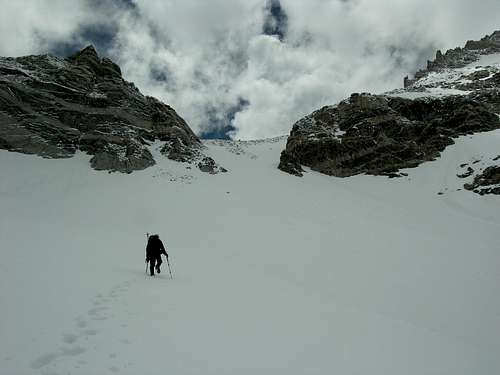
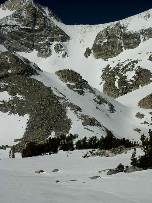
We find the snow in good shape until ~12,500'. From this point forward we are postholing anywhere from 1-2+ feet. While the snow is comfortable, the conditions are quite tiring. We had noticed some weather rolling-in during our ascent of the couloir and opted to reassess once we top out. The weather continued to worsen as we ascended the couloir.
![Ascending the Hourglass 5/27/08]() Ascending the Hourglass on 5/27/08.
Ascending the Hourglass on 5/27/08.At the top we were greeted with sustained 40+ mph winds, with gusts in excess of 60 mph. Snow was falling, and didn't appear to be lessening any time soon. For the second time in 2 days we opt not to continue into deteriorating conditions and descend to Treasure Lakes to make camp for the night. We hope for little accumulation such that we might ascend the couloir in the morning before punting on Mt. Starr and walking out. Such is not our luck...
Morning of the 28th brings even more snow. Damn it, this is after Memorial Day in Southern California, this is not supposed to happen. We inspected the upper Hourglass via monocular. The entire upper rock bands are covered in fresh snow. Based on our previous day's observations that would mean an accumulation of 1+ feet of new snow. Given the postholing we 'enjoyed' the previous day and the likelihood for point release avalanches (confirmed on our return trip a few days later) we decide to hike out and check for weather forecasts and possible beta on the Internet in Mammoth Lakes. Luckily, there is minimal new snow below 11,000', making for a quick descent. We make a point to stop at the Mammoth Ranger Station to express our displeasure at the road closure. They indicate they will call Bishop (holders of the keys/combination) to open promptly...we'll see in a couple of days.
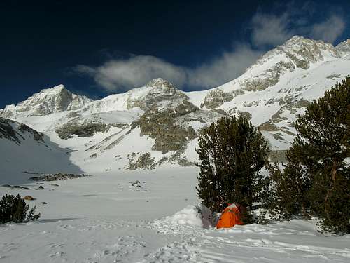
![View from Treasure Lakes 5/28/08]() Bear Creek Spire, the Hourglass Couloir and Mt. Dade from Treasure Lakes on 5/28/08.
Bear Creek Spire, the Hourglass Couloir and Mt. Dade from Treasure Lakes on 5/28/08.Day 4 - Revenge on Boundary
Three days in, and things have not cooperated. Thoughts of moving to Oregon are squashed by reports of a 3,000' snow line and the likelihood of more precip. At least the forecast for the High Sierra is supposed to be clear in two days. The question is what to do until then. An absence of recent beta leads us to a return visit to Boundary. Uncertain as to whether we will be able to drive to the same starting elevation as Monday we prepared mentally to slog an even greater distance during our revenge trip.
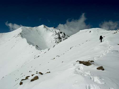
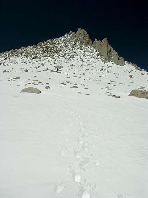
At least this time we were able to view the upper sections of the route from our camp. There was still a substantial amount of unconsolidated snow remaining from the previous storm system. Our assumption is that we get to break trail the entire way, and anticipate significant accumulations above 11,000'. Thus, snowshoes accompany us for a second time...in May. We make good time to 10,000' with minimal postholing due to our early morning departure.
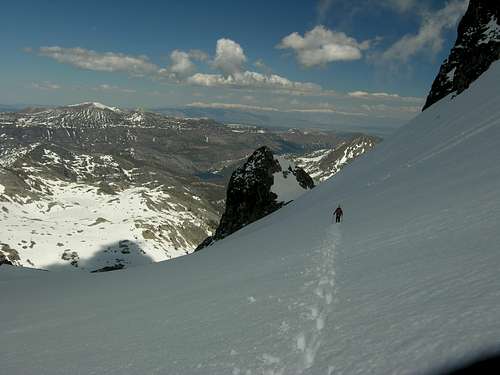
![Ascending Boundary Peak 5/29/08]() Traversing towards the Trail Canyon saddle on 5/29/08.
Traversing towards the Trail Canyon saddle on 5/29/08. However, things would change quickly and by the time we reached the Trail Canyon saddle we were already punching-through in snowshoes.
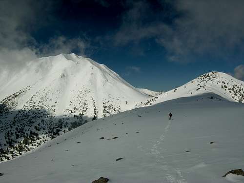
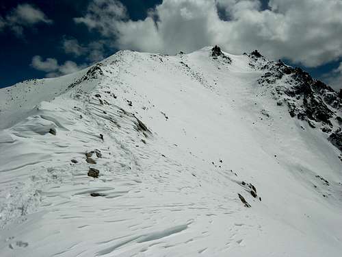
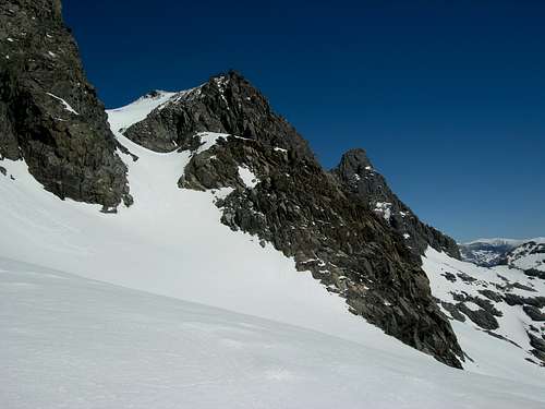
So up we go...the unconsolidated snow gets deeper and our effort increased. We finally got a clear view of our objective and the route, fueling our desire...so on we pressed.
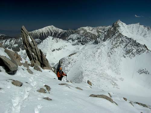
![Traversing above Trail Canyon Saddle 5/29/08]() Traversing above Trail Canyon saddle on 5/29/08.
Traversing above Trail Canyon saddle on 5/29/08. Storm clouds were building in the valleys below, but didn't appear to be advancing so we pressed on for Boundary. We reached the summit, but time nor weather allowed for consideration of the traverse to Mt. Montgomery. After a brief stay and a few quick pics we descended.
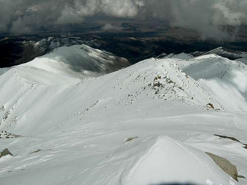
![View of the Queen Canyon Mine Route from the Summit]() Looking down the route 5/29/08.
Looking down the route 5/29/08.![View of Boundary and Montgomery on Descent 5/29/08]() Looking back at Boundary and Montgomery 5/29/08.
Looking back at Boundary and Montgomery 5/29/08.
While long and tedious the descent goes without incident. Upon return to camp we are promptly greeted with a brief hail storm forcing us to take cover in the tent. Thank goodness the weather held off as long as it did, and we finally completed an objective. During a brief lull in the hail we break camp and start rolling towards some grub-n-brews at the Pizza Factory in Bishop.
We finally have a good forecast and a taste of success. The variable right now is the snow accumulation at the upper elevations. We decide to go take a peek at the South Fork of Big Pine Creek to see what the conditions are in the Palisades.
Day 5 - Palisade Recon
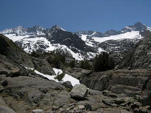
Given our Palisade objectives (Sill/Polemonium traverse from Scimitar, and possibly Middle Pal) we decide that it will take too long if the travel requires extensive use of crampons/ice axe. So we departed from the trailhead with 3 days of food and our minimal gear of comfort for what we classified as a recon trip. We hoped to easily reach Willow Lake and get a view of the upper elevations for an assessment about the feasibility of our plans. After reaching large snowfields on the trail at ~8,800' we know our Palisade plans are a 'no-go'. We dropped most of the overnight gear and decided to scramble up to catch a view and have some lunch before descending to look for fun elsewhere.
![Palisades from above Willow Lake 5/30/08]() View of Middle Pal, Norman Clyde Peak, Palisade Crest, Scimitar Pass and Mt . Sill on 5/30/08.
View of Middle Pal, Norman Clyde Peak, Palisade Crest, Scimitar Pass and Mt . Sill on 5/30/08.Day 6 - Return to Dade
Our defeat at the top of the Hourglass left a bitter taste in our mouths, and even though we like bitter beer a return trip was in order for its removal. We hoped for minimal snow accumulation since our last attempt and for avy release of any instabilities. But first and foremost we wanted the damn gate to be open so we could attempt Dade as a dayhike. Hooray, Bishop ranger station indicates the gate is open, so we are on for an early morning start.
After some coffee, obvious prerequisite, we reached the trailhead a little after 6AM and were shortly on our way. We opted to leave the snowshoes behind, hoping to find conditions similar to our previous attempt a few days earlier. Things are good to Treasure Lakes where we paused for a snack.
![Time for a Break]() Time for a snack below Hourglass Couloir 5/31/08.
Time for a snack below Hourglass Couloir 5/31/08. We found conditions in the Hourglass to be quite favorable and quickly were at the point of our retreat a few days earlier. We ditched the crampons/axes and departed for the Class 2 slope leading to the summit.
![View above the Hourglass]() Mike leading to the Mt. Dade summit 5/31/08.
Mike leading to the Mt. Dade summit 5/31/08.
This is where things got a little spicier than needed. While I am sure this is a quite enjoyable scramble when dry, we were not so fortunate. There was 2+ feet of unconsolidated snow filling in spaces between the talus/boulders, and failing to fill in many large voids. We made slow progress to the top given the conditions. These conditions were quite frustrating.
![Upper Slope of Mt. Dade 5/31/08]() Ascending the upper slope of Mt. Dade 5/31/08.
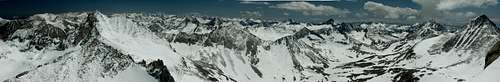
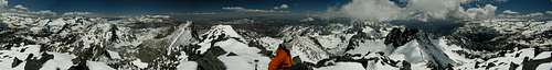
Ascending the upper slope of Mt. Dade 5/31/08.![High Sierra panoramic view from Mt. Dade 5/31/08]() Dade panoramic view 5/31/08.
Dade panoramic view 5/31/08. Descent wasn't any better. We opted to descend our previous track, hoping our steps would be consolidated and solid. This was only the case about 50% of the time. We were both extremely relieved to be back at the top of Hourglass without sustaining a leg fracture or knee injury.
Couloir descent was a mix of unpleasurable plunge-stepping (due to the postholing) and limited success glissade. However, the view from Long Lake on descent was quite nice.
![BCS and Dade from Long Lake]() View of BCS and Dade on descent 5/31/08.
View of BCS and Dade on descent 5/31/08.
Our floundering efforts in unconsolidated snow above 12,500' left us wondering where to go next. What route would be nice with a fresh dumping of 1-2 feet of snow? Our minds turned to Mt. Ritter and the Clyde variation of the SE Glacier route. This should be perfect, especially with snowshoes...in June!
Days 7,8 and 9 - Mt. Ritter: Round 3
Mt. Ritter here we come...for the third time. In 2006 we gave the North Face a shot as a dayhike, but a late start and a case of AMS said otherwise. So back we went in 2007 to hit both Ritter and Banner over a 3 day trip, which included my friend Kristin. She got a little freaked out staring at the NF of Ritter while climbing Banner, so we decided to descend back to camp and Mike and I would attempt the SE Glacier route the next day. Unfortunately Mike reinjured his ankle descending the Ritter-Banner saddle so we would have to wait for another day. That day had arrived.
Even though the gate for road 203 was closed we were up for the slog. Based on our previous experience on Dade we opted to drag snowshoes feeling the extra weight might prove invaluable above 11,000'.
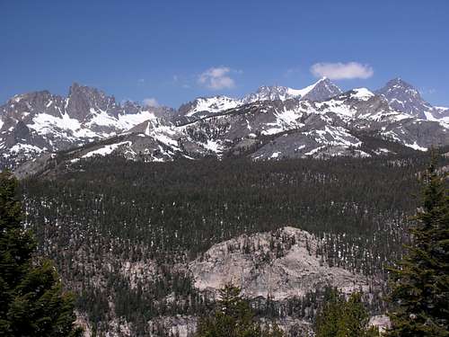
![Ritter Range from Minaret Vista 6/1/08]() View from Minaret Vista 6/1/08.
View from Minaret Vista 6/1/08.
Thinking our previous efforts on Dade might leave us short of energy we only planned to make Shadow Lake the first day. However, our 3 PM arrival (after a near PM departure) indicated there was far too much daylight left to pitch camp now. So we pressed on.
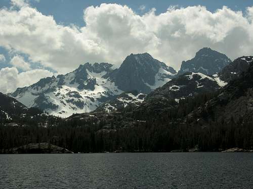
![Ritter-Banner view from Shadow Lake 6/1/08]() View from Shadow Lake 6/1/08.
View from Shadow Lake 6/1/08. Once leaving the JMT the trail was mostly covered with snow, thank goodness for the 2 previous trips and tree markers. We didn't want to take our chances with the North-side of Lake Ediza and opted to use the last bridge to cross to the South-side. The lake was still 95% iced-over. It took a little while to cross the lake inlet and find one of the few dry places to pitch our tent.
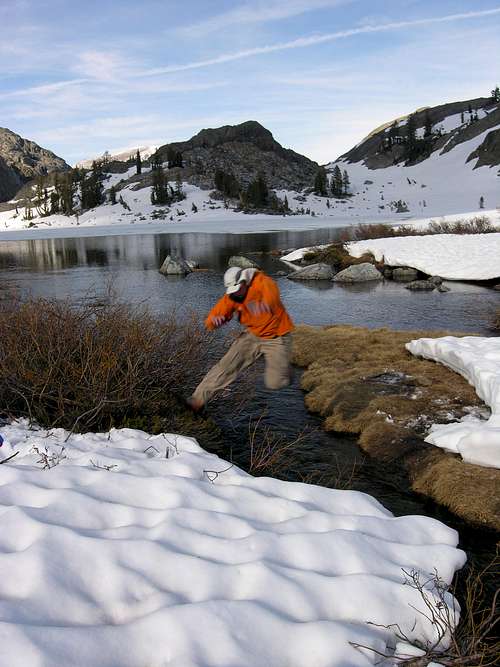
![Catching some air at Lake Ediza 6/1/08]() Crossing one of the Lake Ediza inlets
Crossing one of the Lake Ediza inlets
We opted to start our summit attempt in snowshoes, even given the firm morning conditions. The slope wasn't too steep for worry, and the televator bars on the MSR snowshoes made for a quite enjoyable climb to nearly 11,000'. We continued in snowshoes and circumnavigated the rock band immediately in front of us on its left-hand side. I believe we climbed too high to take the hard right at the top of the gully, mentioned in the route description. Nevertheless we arrived at the col between the Ritter pinnacles, and could view the summit.
![View of the Col]() View of col 6/2/08.
View of col 6/2/08.
We ascended the col in our snowshoes, never once feeling the need for crampons given the unconsolidated snow. At the top of the col we switched snowshoes for crampons during our slight descent and traverse of the SE Glacier. The 'Secor' chute still had significant patches of residual snow, and we thus opted to ascend the glacier around the '3-toed Buttress' to reach the 'Owen's chute'. This chute was mostly free of snow, and we were even able to follow a use trail through some sections. After toping out from the chute we again donned our snowshoes and ascended with them to within ~10 feet of the summit, before removing for dexterity. The summit views were most rewarding and amazing.
![High Sierra panoramic view from Mt. Ritter 6/2/08]() Ritter panoramic view 6/2/08.
Ritter panoramic view 6/2/08.
Descent proved uneventful for the most part. We descended the summit slopes with our snowshoes to account for the unconsolidated snow. Ditched the snowshoes in 'Owen's Chute', but added crampons for the traverse of the SE Glacier (even though they probably weren't needed).
![Traverse of SE Glacier on Descent]() Traverse of the SE Glacier on Mt. Ritter 6/2/08.
Traverse of the SE Glacier on Mt. Ritter 6/2/08. Moved camp about 300' below Lake Ediza and walked out the following day. Were fortunate enough to catch a ride with the Red's Meadow store manager back up to the Minaret Vista gate, saving us over 2.5 miles on the road...they kick ass!
Day 10 - Clouds Rest
Tired of fighting our way through unconsolidated snow, with and without snowshoes, we went looking for objectives requiring far less gear and hopefully with far less snow. When Mike and Mark hiked the Muir trail in 2000, they had planned to dayhike Clouds Rest as a warm-up prior to their departure en route. However, this was never achieved and thus Mike suggested it as an objective. While the trail from the 'Big Ditch' was very unappealing, we were intrigued about the Tenaya Lake option mentioned by Secor.
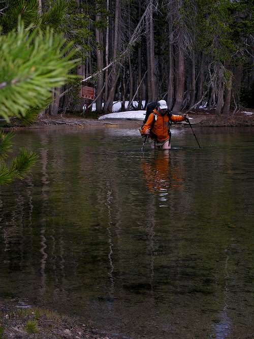
Not sure how much snow might remain/have accumulated above 9,000' we chose to carry our snowshoes, but luckily didn't end up needing them. Things were off to a wet start right away crossing the Tenaya Lake outlet.
![Trail traverse at Tenaya Lake 6/4/08]() Off to a wet start in Tenaya Lake on 6/4/08.
Off to a wet start in Tenaya Lake on 6/4/08. The trail was ~60-70% under snow. We helped two different parties regain the trail after they lost it during various creek crossings. The NE ridge is quite a nice hike. There were 8 people on the summit, including us, but the views more than made up for the lack of solitude. The summit views were some of the best we have ever experienced in the backcountry.
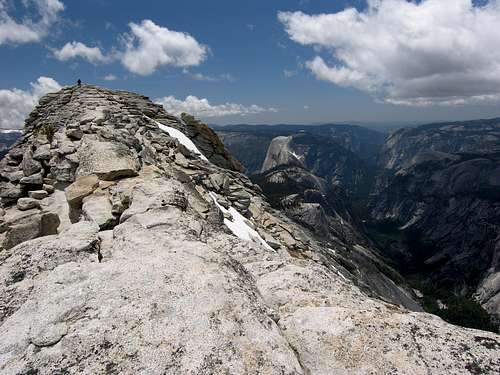
![Yosemite panoramic view from Clouds Rest 6/4/08]() Panoramic view from Clouds Rest summit 6/4/08.
Panoramic view from Clouds Rest summit 6/4/08. Can't quite understand why everyone hikes Half Dome, when Clouds Rest kicks its ass. Views of almost the entire park. I would recommend it to anyone without pause, but would recommend the Tenaya Lake trail over the Valley option.
![Mike summiting Clouds Rest 6/4/08]() Mike topping out on Clouds Rest 6/4/08.
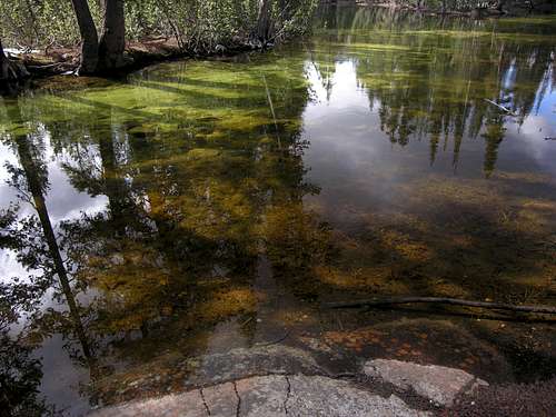
Mike topping out on Clouds Rest 6/4/08.![Reflection in Tenaya Creek]() Reflection in Tenaya Creek on 6/4/08/
Reflection in Tenaya Creek on 6/4/08/Day 11 - El Capitan finale
While we didn't need snowshoes on our previous outing to Clouds Rest, we'd clearly enjoyed the fresh and residual snow to the fullest extent. As such we set our sights on the Yosemite Valley for a final objective to close the trip.
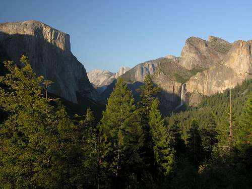
![Entering the Valley 6/4/08]() Entering Yosemite valley 6/4/08
Entering Yosemite valley 6/4/08 Mike and Mark had planned to dayhike El Capitan from the valley before starting the Muir trail in 2000, but since life conspired against its completion it felt like a fitting objective. While we would not find the solitude we had previously enjoyed on this trip, the ~20 miles and 4,000' of gain over the day would more than make it worthy.
The Yosemite Falls trail wasn't overly crowded, but it was a Thursday. The views during ascent were quite enjoyable, and most parties were courteous and let us pass with ease.
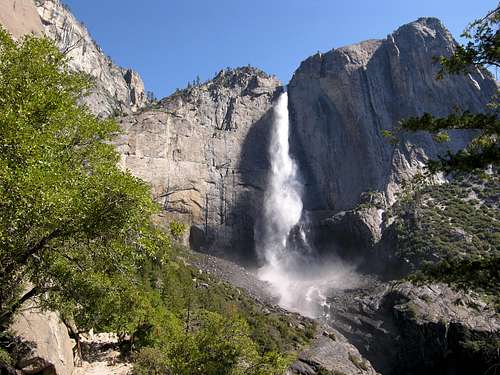
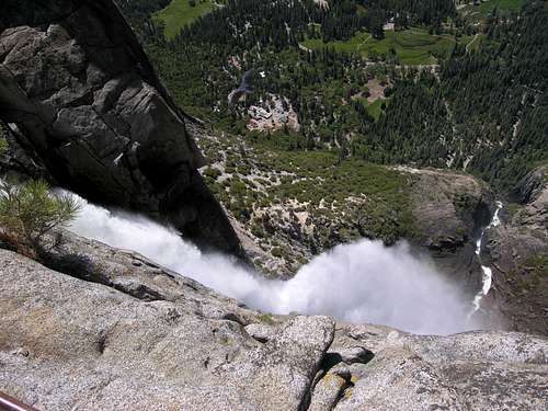
![Yosemite Falls 6/5/08]() Upper Falls 6/5/08
Upper Falls 6/5/08 We quickly found ourselves at the top of the falls, enjoyed the views before bidding adieu to the masses and setting out for the top of El Cap.
![Overlook view 6/5/08]() View from Yosemite Falls overlook 6/5/08
View from Yosemite Falls overlook 6/5/08
The trail was in good shape, and we only encountered two very small snow patches. What a change over the previous objectives. We thoroughly enjoyed our trail time to the top of El Cap, and views were nice too.
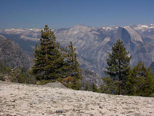
![View of Clouds Rest and Half Dome 6/5/08]() View of Clouds Rest and Half Dome en route to top of El Cap 6/5/08
View of Clouds Rest and Half Dome en route to top of El Cap 6/5/08 After a brief exploratory session on the upper slopes of El Cap we started our descent to the valley floor. We met very few individuals until rejoining the falls trail. Views on descent were also quite enjoyable.
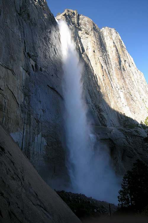
![Upper Yosemite Falls on Descent 6/5/08]() View of upper Yosemite falls on descent 6/5/08
View of upper Yosemite falls on descent 6/5/08 After returning to our vehicle we set out for a cold brew and a hot meal to finish off 11 great days in the backcountry.


Comments
Post a Comment