The Whites
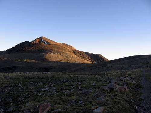
![The White Mountains]() The White Mountains dominate the eastern horizon of Mono County
The White Mountains dominate the eastern horizon of Mono CountyI suppose it starts the same for everyone, a look over from a summit in the Sierra to the White Mountains sparks an urge to explore the tall, barren desert range. Then, forays to the Bristlecone Pine groves and White Mountain Peak lead to an intense curiousity about the ridge beyond the peak, the long rolling ridgeline between White and Montgomery, where Desert Bighorn run among the rocks and the wild horses forage in the flats.
And so it started with me. Almost thirty years ago, a planned backpack traverse of the Whites fell victim to circumstance and lack of will. Subsequent opportunities would have taken too much time away from family, so all invitations were declined. The idea of the Traverse faded with time, but the ridgeline was never forgotten, you can't help but see the distinctive silhouette of the Whites everyday from Mammoth, thirty miles away.
The Big Idea
Barry doesn't even know how much an inspiration he has been for me. A regular guy with a job and family building a house after work and on weekends. I had to get off my butt, and build a house too. Many months later, we were standing in the middle of my nightmare of frozen lumber, lamenting the old days when weekends were for hiking, when he mentioned the Traverse - a dayhike of the Traverse.
All of my suppressed desire to traverse the big, desolate range boiled over. The more I worked on the house, the more I thought of the Traverse. The hike would represent a return to the mountains after many months of grueling labor. But the hike would be big, huge in fact, the kind of hike I could have done when I was younger...but not anymore, and that was a big reason to do it.
When the house was done, not that the house is really done, it is really in a prolonged stage of 'just a little more to do', I began to train in earnest for the hike. Running after work, riding to work, laying floor tile. Once a week I ran up Rock Creek Road or up from Mosquito Flat to Mono Pass, but on the drive down to Tom's Place, I would always look up to Montgomery Peak - way up to Montgomery Peak and doubt would fill my bones.
Is it really possible to hike that far, that high in one day?
Barry would ask the same question many times. I measured the distance on a road map. Twenty-four maybe twenty-five miles, not counting turns, ups and downs, and whatever. Fairly easy. Other numbers came up. Forty-something! No way! Thirty-eight. Thirty-four. Those sounded better.
Internet research found a Traverse backpacking excursion that resulted in a badly injured arm, a backpacking group that bailed because of weather, and a Traverse dayhiker who didn't summit Montgomery until 4am because of an injured foot. The stats weren't looking too good for us. We needed some real data.
Scouting Hikes
![The Northern Whites]() The northern Whites taunt me on a scouting hike.
The northern Whites taunt me on a scouting hike.Marmots, golden eagles and bighorn sheep watched me hike White Mountain in a fair 2:08 and venture north to scout the best route though the class 3 mess just beyond the peak. The rock was ugly, and my attempt to cross it was uglier. Both of my knees have old, unrepaired injuries that make the simplest scramble simply impossible. My circuituitous detours around small obstacles ate up one hour for a quarter mile. I cached a couple water bottles on the plateau just past the broken ridge and turned back. I dropped down a gully to the scree east of the class 3 section, traversed some broken slabby crap and cruised up a snowfield to the ridgeline. Much better, half an hour and never broke a sweat. Jogging back to the car with a detour over Barcroft Mountain, I got a nasty high altitude headache and made a mental note to work on pacing for the Traverse.
The scouting trip of Boundary, Montgomery, and the Jumpoff was an absolute blast as I always enjoy a good screeslope. I tried hiking with poles for the first time and I found that cross country ski poles made perfect scree-poles. The scramble from Boundary to Montgomery was interesting, but from Montgomery down to the notch below Jumpoff was good clean fun. Routefinding puzzles, sheep tracks, lion tracks, and the best rock of the day made the ridge a personal favorite. I cached a couple more water bottles and returned to the car in three and a half hours at a mellow pace.
Barry was having serious doubts about the dayhike idea. My time estimates for the hike varied wildly until I settled on a loosely calculated 14 1/2 hours. Neither of us really knew what lay between White Mountain and the Jumpoff, and both of us knew the west side of the range is cliff city and the east side of the range is bushwhack territory. Rescues in the Whites are not easy either, with high altitude and high winds blowing out the chances of helicopter rescue. We needed to take care of ourselves and each other, and I couldn't have a better partner than Barry.
Barry is built for the Traverse. Lean and agile, he can cross a loose talus slope at high speed, changing stride to step on only the stablest rocks, and moving quickly to the next landing if a stone rolls away. He has many long distance peak bagging epics under his belt, so he knows how to deal with the extreme demands of the Traverse. Most importantly, like me, he has a family and a job to come back to, so we would be sure this hike would not resemble a suicide mission.
The Traverse would require a 2 1/2 hour car shuttle in addition to the 2 1/2 hour drive to the trailhead along the Flat Tire Highway ( White Mountain Road ), so I enlisted my wife to help me drop my Tundra at the Queen Canyon Saddle, the nothern terminus of our planned adventure. As we mountain biked back down Queen Canyon Road to her car at Hwy 6, a Mountain Mohagany grabbed Cathy and threw her to the down onto the rocky roadbed. This hiking business gets pretty serious when your wife sheds blood on the car shuttle.
The Big Day
Hike day started at 1am for Barry as he drove down to pick me up on the way down the Eastern Sierra, through Bishop and up to the Whites. We arrived at the Arbitrary Point Trailhead, a locked gate across the perfectly fine road, just after 4am. Hikers were emerging from their roadside camping spots, slowly readying themselves for attempts of White. I was surprised to see them up so early. There would be no threat of thunderstorms, so why not sleep in?
The whole alpine start thing has always been a puzzle for me. Why start hiking in the dark to avoid finishing in the dark? Truth is, I'm always up late, and awake fairly early, but this really, really early stuff gives me a 'kicked in the head' feeling. Of course, we had a good reason to be starting while the roosters slept, we had a really, really long way to go.
Our starting pace was quick but reserved. No use burning up the legs early, there would be plenty of time for that later. We soon passed a party of three, and after exchanging hello's, all would have been quiet except for the incessant chirping of unseen small birds in the grasses along the rocky road. It was nice to have the music. Soon we passed the Barcroft Research Station, where I believe they are studying sheep for the effects of long term exposure to diesel generator fumes.
![White Mountain Sunrise]() The typical sunrise on White Mountain Peak photo
The typical sunrise on White Mountain Peak photo
The view of the summit of White Mountain Peak as one tops the observatory hill is perhaps the best example of the distance distortion that commonly occurs in the Whites. "This won't take long," has probably crossed every hiker's mind as the peak seems so close with no trees or peaks to block the view-- or to give perspective. Time flies as the trail drops into a shallow valley and climbs up northeast toward the ridgeline. A lone coyote trots along in the predawn on a slope that will soon be crawling with huge marmots. Barry told me about the day his father drove his family to the top of White in their truck, now the road is a doubletrack hiking trail sometimes driven by researchers or rescuers.
Light began to play with the rocks of the peak and with the Sierra just across the Owens Valley. The rich colors of the rocks on White Mountain Peak changed by the minute as the sun rose over central Nevada. The skies were clear as a northwest wind blew away the smoke haze that had blanketed the area for weeks. A high wind warning was in the forecast so we were looking forward to an ample supply of fresh air.
Barry reminded me of his Bighorn Sheep jinx on the drive up. The poor guy had been climbing mountains, lots of mountains, for many years, but had never seen any sheep. So, as we approached White Mountain Peak, we scanned the slopes for any sign of the animals. Just east of the summit, eight sheep grazed the rocky mountainside. A couple of cute lambs scampered around trying to keep up with the roaming herd. Barry's jinx was broken. Broken big time. We watched them roam to the east then south.
![Desert Bighorn]() Barry's first sheep
Barry's first sheep
Two and a half hours into our ordeal, we neared the summit of White Mountain Peak. The entire north end of the range came into view as we approached the last switchback turn of the trail. We turned to look at the summit. "Do you want to touch the top?''
"No, we've both been there before," Barry replied.
"Right on." I was quite relieved that we wouldn't be trying to touch every 'bump in the ridge', as I think Barry calls the many named summits along the route. Barry estimated our vertical gain for the hike would be about 10,000 feet without the peaks, which would be quite enough.
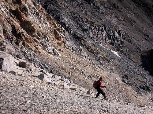
![Telescreeing]() Telescreeing
Telescreeing
We dropped down to a saddle just north of the switchbacks and I pointed out the class 3 bypass that I had found on the scouting trip. Barry cruised across the detour and out of sight.
![Class 3 Bypass]() Class 3 bypass
Class 3 bypass
I struggled to keep from tumbling down on some loose rock. My legs were stiff from the hike up and the big steps down were pulling my knees apart. After an embarrassingly long time, I ascended a scree gully to regain the ridge and quickly found the water bottles I had stashed weeks earlier. Neither of us needed water as it was still near freezing and we had not been drinking.
The ridge mellowed out considerably but the footing was tricky on loose ankle-busters. The rocks were all ready to roll, necessitating some pretty light footwork to keep from upsetting the boulders. I imagined dancing along on the snoozing talus whispering "Excuse me , pardon me" to keep from waking the rocks from their slumber.
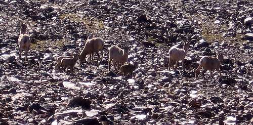
Counting Sheep
![More Sheep]() More sheep getting in the way
More sheep getting in the wayAs we began a descent to a saddle, more sheep, about 25 this time. We watched them scurry off the ridge, over the saddle, and down a small ridge. Another couple dozen sheep were startled by the first herd and followed over the saddle. We spotted more sheep on a ridge in the distance.
![Sheep on a Distant Ridge]() Sheep on a distant ridge
Sheep on a distant ridge
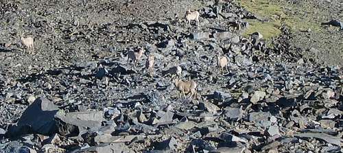
We began to tally up our sheep count. 8, 25, 20, 20, we were feeling pretty lucky to see that many sheep, really more than I had imagined could live in the Whites. Then a beautiful rocky meadow held 35 more, all of whom were gone before we could get within photo distance.
![Sheep s Perch]() Bighorn take refuge on a rocky ridge.
Bighorn take refuge on a rocky ridge.![Barry]() Barry takes step 34221
Barry takes step 34221We kept a fast pace as we dropped toward the low point of the ridge, picking routes around the many small summits, sidehilling instead of summitting. Though I definitely had an altitude buzz going, we were going just slow enough to avoid a headache. Barry said he calculated that we would each take about 100,000 steps during our hike. 34 miles times 5280ft, 2 feet per step, some steps bigger, some smaller, sounded like 100,000 steps.
![Easy Terrain]() Some easy terrain heading to the low point.
Some easy terrain heading to the low point.The Low Point
![Low Point]() Birch Creek/ Cabin Creek saddle with White Mountain Peak in the background.
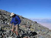
Birch Creek/ Cabin Creek saddle with White Mountain Peak in the background.Birch Creek and Cabin Creek almost touch at the saddle west of Chiatovich Flats, and at 11,200 ft this would be the low point of the Traverse, and the 16 mile mark. A few healthy mule deer bolted as we followed game trails through the sagebrush north of the saddle. While we made quick work of the descent into the saddle, the climb over a small ridge and up a sandy valley to the 12,000 foot Pellisier Flat took over an hour.
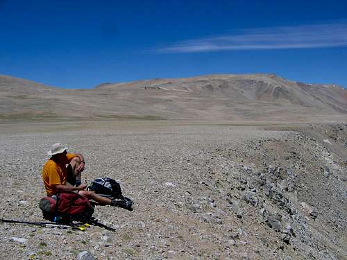
![Lunch Break on Pellisier Flat]() Lunch break on Pellisier Flat
Lunch break on Pellisier Flat
The white sand and rock of Pellisier Flats are very different from the dark rocks of the White Mountain Peak area. Small flowers were scattered everywhere, but were nothing like the green meadows we had seen earlier. We lunched above a cirque on the east side of the huge plateau, and climbed ever so gradually above 13,000 feet to Mt Dubois. From there we got back into the talus hopping business as the ridge narrowed up a bit. Fatigue was kicking in and we found the two miles to The Jumpoff to be long ones.
![Barry Pauses at The Jumpoff]() Barry views Montgomery Peak from The Jumpoff
Barry views Montgomery Peak from The Jumpoff
The Jumpoff sports many scary fissures formed as large parts of the mountain are sluffing off into the canyon below. Crossing the fissures is the fastest way across the mountain, but I planted my scree poles firmly to test the stability of the ground, just as I would test a snowbridge. We stopped briefly at The Jumpoff to look ahead to the broken ridges of Montgomery and Boundary peaks, and the deep notch that lay between us and the last two mountains of the day. Just ahead was a drop of over 1000ft on bowling alley quality talus to a saddle at 12,100ft, then a 1300ft class 3 gain to Montgomery.
![Bowling Alley]() The bowling alley on the north ridge of The Jumpoff
The bowling alley on the north ridge of The Jumpoff
The descent was trashy and noisy with rocks tumbling away beneath our feet. I carefully chose routes that did not cross above Barry to minimize the possibility of rolling a boulder toward him. A Bighorn relinguished his bed in the saddle as we approached. Our sheep count was over a hundred now, the sighting of this one barely slowed us down. So much for Barry's jinx.
Fuel Shortage
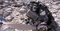
![Old Wreckage]() Aircraft wreckage in the notch below The Jumpoff
Aircraft wreckage in the notch below The JumpoffOur arrival at the Montgomery Creek saddle was a huge relief for me, as the rest of our route was familiar territory. I relaxed for a while as Barry inspected the wreckage of an aircraft that had come up short flying through the high pass. Suddenly I felt drained. While looking for the water I had stashed weeks before, I became a little confused, a little dizzy, and a lot concerned. We had gone 26 miles in 11 hours, but we still had 8 rough miles to go. I had never spent such a long time above 12,000 ft, and I was feeling it. I realized that I had not been eating much since lunch, and I needed fuel immediately. I choked down a Cytomax and Clifbar cocktail as we ascended the south ridge of Montgomery.
![Climbing Montgomery s south ridge]() Climbing Montgomery's south ridge
Climbing Montgomery's south ridge
My tracks from weeks before took a lot of the guesswork out of the routefinding on the steep ridge. We traversed just under Montgomery's summit and headed for Boundary.
The high winds were buffeting us around pretty good on the exposed ridges, as they had all day. Looking far to the north, we could see a smoke plume stretching for miles across the Nevada desert. Later we would learn that the smoke was from the Angora Fire in South Lake Tahoe, over a hundred miles northwest of us.
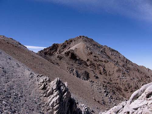
![Boundary from Montgomery]() Boundary Peak would be our last peak of the hike.
Boundary Peak would be our last peak of the hike.
We took about an hour to traverse from Montgomery to Boundary along the broken ridgeline and short use trails. My energy was returning and I focused on getting across with out getting hurt. I knew easier terrain lay just ahead.
After a quick review of the latest entries in the Boundary Peak register, we picked our way down the network of use trails through the rocks and scree that make up the north ridge. My scree poles were whipping around as we flew down the mountain. After a short stop at Trail Canyon Saddle, a dozen wild horses watched us turn up the pace for the last few miles along the ridge that leads to Queen Canyon Saddle. When we spotted the Tundra at the trailhead, we started running down the switchbacks to finish our little dayhike in 14 hours, 45 minutes.
Soon, we were cruising Hwy 6 with both of us looking to our left, checking out the route that had just kicked our butts. The scree slopes of Boundary look smooth and magical from the highway. Montgomery just looks rugged as hell. Jumpoff looks a lot more solid from below. Dubois, wait which one is Dubois? The ridge is massive, and long. Half an hour later at 70mph, just past White Mountain Ranch, we were still looking up to spot the saddle where Barry's truck waited for us. We still had to drive a couple of hours to get back to the trailhead. Luckily, friends picked up Barry's truck after a hike to White Mountain and met us before we got to the hellish dirt section of the road, saving us at least a couple hours on the car shuttle deal.
While I can't tell you how Barry feels about our hike, I can tell you that I have a huge sense of accomplishment every time I look up to the Whites. The hike was every bit as tough as we expected, and every bit as wild. And I can't help but wonder, "Could I do it again?"


Comments
Post a Comment