Nevada's highpoint in late winter
I had been considering attempting Boundary Peak in conjunction with a convention I planned to attend in Las Vegas. When highpointing, if you find yourself within 300 miles of an objective, you rent a vehicle and go for it, or you might never get all 50 states done!
But Boundary is notable for its isolation. That isolation, combined with the fact I would be solo, in winter, complicated the decision. In the end, I decided to try it and learn from the experience, whether successful or not.
The approach
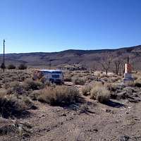
I drove up US 95 and various Nevada highways to get to US 6, just east of the California border. Turned onto the Queen Mine road at Janie's Ranch. Only in Nevada could the landmark info be "take the dirt road directly across from the abandoned brothel."
![Queen Mine Road landmark]() Turn here for Queen Mine road
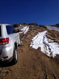
Turn here for Queen Mine road2014 has been a historically low-snow winter in the eastern Sierra, and the road was passable to just above the mine itself. I was able to get the Jeep up past the mine, but deep snow prevented me from getting all the way up to Kennedy Saddle.
I settled in for an uncomfortable night of car camping.
The climb
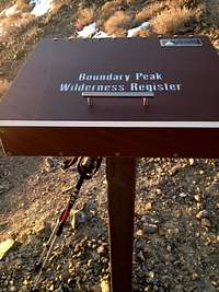
I was awake at 4 a.m., but distinctly unmotivated to get out of the bag and start climbing. Probably fear of the unknown. At any rate, I did get moving before dawn, with breakfast and coffee, and started the walk up to Kennedy Saddle by about 6:40. The Highpointers Club has installed a dandy new trail register box at the trailhead. Thanks, fellow highpointers!
The first 900-1,000 feet of elevation gain came with difficulty. The trail was frequently obscured with drifts, some thigh-deep, and was hard to follow. It does switchback in this section, so going straight up usually led me back onto the footpath eventually.
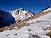
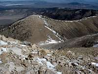
2 hours into the walk, I rounded the shoulder of the long ridge that runs to the southwest towards Boundary and got my first look at today's objective. It was inspiring, and a little daunting, but nothing I had not seen before in photos taken from exactly this same spot.
![First glimpse of Boundary]() My first look at Boundary in mid-March
My first look at Boundary in mid-March
The ridge walk has southern exposure, and was easy, if longer than I expected, since there was little snow to slow progress. I arrived at the saddle that sits just below the start of the actual climb at about 9:30 a.m.
The reckoning
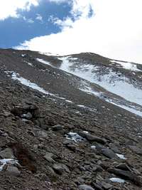
I've been on scree and thought I had a handle on it, but Boundary Peak scree is next level. For each foot of elevation gain, I lost 4 inches in slippage, and making matters worse, the use trails that lead up this scree slope were occasionally snow-covered and imperceptible.
Again, as I had found lower, if I went straight up, I regained the trail at one of its many switchbacks, but if you have ever been on hands and knees fighting your way up a rock pile that gravity is pulling downwards, you may be able to empathize. It was, shall we say, demotivating.
This part of the climb took me about 2 hours, and I topped out on the scree at 11:30 at about 12,000 feet and took stock of my situation. I was tired, alone, and had given those waiting at home a pretty firm time that I would check in on the day of my summit attempt. In calculating my speed, the time of day, and my promise to call or text later that day, it became clear that I should turn around. This view helped convince me.
You can see the snow covered trail running diagonally up from left to right and you can also see the exposure for a potential fall along that trail. I figured another 2 hours to summit, perhaps more, since I live at sea level in my real life and the altitude was working its magic on me at this point.
Lessons learned
I seldom turn back on a hiking or climbing goal, but I'm glad I did this time. I learned a few things for my next attempt on Nevada's highpoint:
Go social - For me, attempting this climb solo in winter was unlikely to lead to success, in retrospect. Having the company of a fellow climber might have offered the margin of safety I felt was lacking while I was solo.
Alpine start - I usually prefer these, and had I been moving at 4 a.m., this trip might have had a different outcome.
Pick a favorable season - there is a reason the overwhelming majority of trip reports on Boundary Peak are written about hikes that occur from June through September. The scree, the altitude, and the remoteness combine to make this mountain tougher than you might at first expect.
More water, less beer - Speed usually equals safety in the mountains, and had I been able to power up that scree slope in one hour, not two, I might have felt comfortable with how much more mountain I had left when I stopped for lunch. My sedentary job in real life means I need to train harder and longer to be in shape for Boundary and other western state highpoints.
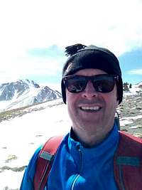
All in all, in this photo
![No summit today]() Lived to hike another day
Lived to hike another dayI appear to be mighty pleased for someone who just failed to accomplish his stated objective, but it's also likely a face of relief to have made the safe decision. It paid off because I blasted down to Flagstaff the next day and safely hiked to the top of Arizona on Sunday March 16. That trip report on Humphrey's Peak is forthcoming.
Comments
No comments posted yet.