TRIP PROLOGUE
During late July, several local peakbagging friends informed me that a special, possibly one-time, event was occurring in Nevada during the weekend of September 10-11, 2011. Mount Grant, the Mineral County Highpoint, is located on Hawthorne Army Depot and the area has been prohibited to public access since September 11, 2001. However, in remembrance of the 10th anniversary of that tragedy, several county highpointers, especially Bob Sumner, were finally able to convince local military personnel to allow a one-time public event, a 17-mile road race to the top of Mount Grant named the
9/11 Mount Grant Memorial Challenge.
The event was originally setup as a relay race, with teams of four people each signing-up to attend. However, some people wanted to do the entire 17 miles solo rather than be part of a team. Eventually, the “relay race” idea was eliminated despite the teams and four route checkpoints/sections remaining intact. In my situation, I had found out about the event several weeks after many of the attendees had already signed-up, and most of those participants were already in four-person teams. As a result, I initially thought if I attended I would be going solo, which was fine with me but I thought it would be more fun with at least one teammate. Also, if I was already heading to Nevada then another priority there would be to attempt Boundary Peak, the State Highpoint. There was going to be a limited number of people (50-75) originally allowed to take part in the Mount Grant event, and only a few spots remained when I heard about the event, so I had little time to waste if I were to find any teammates and sign-up. Looking for county highpointers who had not yet summited Mount Grant or Boundary Peak, I immediately contacted our very own Mike Collins.
Mike and I had written each other several times during the past few years to try to coordinate a trip to Boundary Peak. None of those plans ever materialized, so Mike immediately agreed to come with me to Nevada for this trip. With no other teammates, I dubbed us
TEAM NWH, with the "NWH" part in reference to us both being
Northwest hikers. I apparently sent in the application form for the event just in time, as I know of several people who had sent in application forms within a week of me and were told that all the participant spots had already filled.
THE TRIP BEGINS WITH A BOUNDARY
Mike and I flew down to Nevada on Friday afternoon, September 9. Surprisingly, the first time I had ever met Mike in-person was at Sea-Tac Airport for this trip. After arriving in Reno, we drove down to the city of Hawthorne, located in west Nevada. I estimated this city to be only 1-1/2 hours or so from the Boundary Peak trailhead, as well as only 15 minutes or so from the Mount Grant event, so I had reserved a room at the
El Capitan hotel for Friday and Saturday night. We arrived there during early evening hours, and got a few hours’ sleep.
We woke up at 4:30 AM on Saturday and left the hotel at 5:00 AM. We planned to approach Boundary Peak from the east, via Trail Canyon Trail. The driving directions for the Trail Canyon Trailhead that Mike had brought with him were excellent, referencing every major turn and landmark along the old dirt road system. We arrived at the trailhead by 6:15 AM, sooner than we expected, and were hiking by 6:30 AM. We were each shocked that no other vehicles were there, considering the number of people who had signed-up for the Mount Grant event that was to occur the following day.
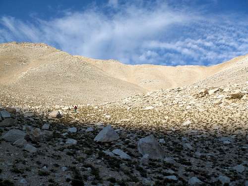
The weather was fantastic; the early morning temperature was comfortable and there were no clouds in the sky. I enjoyed the first half of this summit approach. Trail Canyon was surprisingly green and we walked along a well-defined path through a large valley meadow. We saw several deer foraging near the trail. Rather than continuing off-trail to the Trail Canyon Saddle, the trail definitively turned left towards a gully closer to Boundary Peak.
![Trail Canyon]() In Trail Canyon
In Trail Canyon
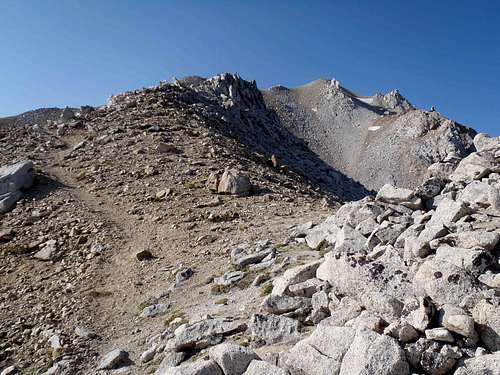
From this point, the trail was still well-defined but became comprised of gravelly sand. The sandy composition of the trail made the ascent sluggish, but manageable, until reaching the ridgetop above (~12100’ elevation). From the ridgetop, a well-defined trail led through bouldery sections to the summit of Boundary Peak… my 41st State Highpoint and Mike’s 27th State Highpoint. After signing the summit register, Mike decided to take a short rest while I enjoyed the views.
![Ascending Sandy Gully]() Ascending Route Up Gravelly Sand Gully
Ascending Route Up Gravelly Sand Gully![Boundary Peak Ridgetop]() Atop The Ridge, Looking At Boundary Peak
Atop The Ridge, Looking At Boundary Peak![Boundary Peak Summit]() Boundary Peak Summit, Montgomery Peak In Background
Boundary Peak Summit, Montgomery Peak In Background![Boundary Peak Summit]() Me, At Boundary Peak Summit
Me, At Boundary Peak Summit![Boundary Peak Summit]() Mike Reading Summit Register
Mike Reading Summit Register
We encountered five people during the descent. The first three people we passed made it to the summit, while the next two people turned around out of concern for time and possible bad weather approaching soon. We stopped to socialize with each of those groups. With rest breaks and socializations, we were able to do the entire trip in seven hours. It easily could have been six hours or less for us if we had not stopped so much to socialize, but this was our only hike planned for that day so time was on our side after the summit was reached.
For those people reading this trip report, don’t believe the hype about this peak. Contrary to many reports, a well-defined trail/route leads from the Trail Canyon Trailhead to the summit, with possibly only a few places in the bouldery upper slopes where the trail might seem to disappear but is still easy to trace. Also, many reports warn or complain about the “loose scree” on the approach. For us Northwesterners, I would not put anything Mike and I encountered in the “loose scree” category; the worst loose stuff we encountered was soft gravelly sand. However, if we had been off-trail/off-route, loose scree-like rocky terrain could possibly be encountered but still not like the “loose scree” found in most of the Washington Cascades.
9/11 MOUNT GRANT MEMORIAL CHALLENGE
We arrived back in Hawthorne shortly before 4:00 PM. After changing our clothes and getting cleaned-up from our hike, we headed to a local park. The park was the registration/check-in location for the following day’s Mount Grant event. We welcomed the free BBQ dinner, as well as the free t-shirts for participants. It was great to see some of my peakbagging friends there, too, as well as some people who I had wanted to meet in-person for a long time. In example, one of the teams,
TEAM EVERGREEN, was comprised of my friends Bob Bolton, Ken Russell, Greg Slayden, and Duane Gilliland, all of whom were from my home state of Washington. In addition, I met other famous peakbaggers, such as Don Nelsen and Bob Burd, for the first time.
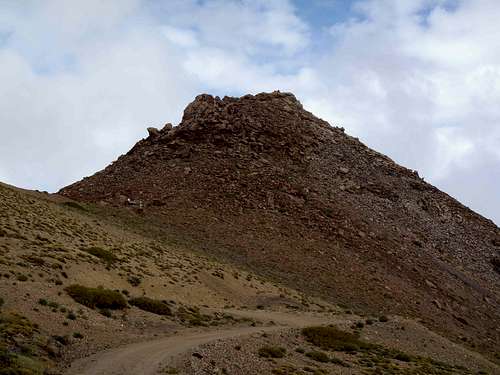
![9/11 Mount Grant Memorial Challenge]() Mount Grant, As Seen During Our Return To Hawthorne
Mount Grant, As Seen During Our Return To Hawthorne![9/11 Mount Grant Memorial Challenge]() Some Participants At The Pre-Event BBQ
Some Participants At The Pre-Event BBQ![9/11 Mount Grant Memorial Challenge]() Getting Details For Following Day's Event
Getting Details For Following Day's Event
After spending a few hours at the BBQ, we headed back to our hotel and got a full night’s sleep. Or at least Mike did. I, on the other hand, with my genetics not allowing me to sleep what most people would consider a full night’s sleep, only slept from 9:00 PM to 2:00 AM. Then I was awake for a while, before finally napping for another hour before we had to get ready to go after 6:00 AM.
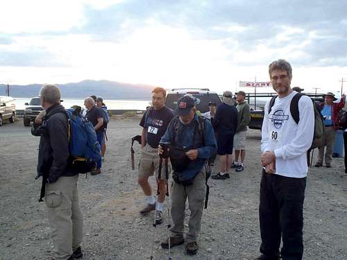
We arrived at the parking lot for the
9/11 Mount Grant Memorial Challenge at 6:15 AM. We were very early, as solo hikers were originally scheduled to begin at 6:30 AM but teams (such as ours) were scheduled to begin after 7:30 AM. It turned out to be a blessing in disguise that Mike and I, as with most of the event participants, arrived early, as a fatality automobile accident occurred shortly after 7:00 AM between the event parking lot and Hawthorne, completely closing the highway. (The highway would not open until seven hours later!)
Although nearly every team was comprised of four people, with each person averaging between 4-5 miles, our team (
TEAM NWH) had a greater jaunt. Mike and I had debated which of us would take the first half of the trek (~9.0 miles) and which of us would take the second half of the trek (~7.5 miles); I originally was to take the first half and Mike take the second half, but the previous day we decided to switch it around. The event was structured so that vans and SUVs would take participants to their designated starting points, known as Checkpoint 1, Checkpoint 2, and Checkpoint 3. Mike was to hike from the START line to Checkpoint 2, and then ride a vehicle to the FINISH line, while I was to hike from Checkpoint 2 to the FINISH line. From the FINISH line, each of us would then hike up a road and ascend a rocky summit block (Class 2) to the summit.
![9/11 Mount Grant Memorial Challenge]() "TEAM NWH" Prior To Event
"TEAM NWH" Prior To Event![9/11 Mount Grant Memorial Challenge]() "TEAM EVERGREEN" Prior To Event
"TEAM EVERGREEN" Prior To Event
At nearly 7:30 AM the various vans and SUVs departed, each carrying several participants to their designated starting points. After the vehicles departed, the remaining participants (such as Mike) began hiking from the START line. My vehicle stopped once while en route, so that we could see a black bear and her two cubs near the road.
![9/11 Mount Grant Memorial Challenge]() Black Bears Along Approach Road
Black Bears Along Approach Road
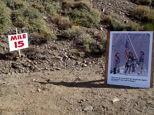
At 8:10 AM, I was dropped-off at Checkpoint 2, the 9-mile marker, right behind a vehicle carrying Duane Gilliland. After briefly walking together up the road, knowing I had two route sections to hike while he only had to hike one route section, I began a combination of jogging and walking ahead of him and the bulk of the group. At 9:10 AM, I reached Checkpoint 3, the 12.7-mile marker. After a brief four-minute break allowed for a Gatorade drink and a group photo opportunity, I began hiking the second section of my trek.
![9/11 Mount Grant Memorial Challenge]() The Hike Begins...
The Hike Begins...![9/11 Mount Grant Memorial Challenge]() Looking Back At Other Hikers
Looking Back At Other Hikers![9/11 Mount Grant Memorial Challenge]() The Goal Looks So Near Yet So Far Away...
The Goal Looks So Near Yet So Far Away...![9/11 Mount Grant Memorial Challenge]() Approaching Checkpoint 3...
Approaching Checkpoint 3...
I knew one other person who had hiked between Checkpoint 2 and Checkpoint 3, like me, was planning to continue hiking to the FINISH line, while the other people were originally going to wait for motorized transport. I soon continued my hike, but the rest of the hikers ultimately all decided to continue as well rather than wait an undetermined amount of time for the motorized transport to arrive. Two of the other hikers eventually passed me within the final ½-mile stretch to the FINISH line, but I still reached the FINISH line prior to the first motorized transport vehicle arriving from further down the route. After a couple of photos and checking-in with the event personnel, I continued to the summit.
![9/11 Mount Grant Memorial Challenge]() Nice Tribute Seen Between Checkpoint 3 and FINISH Line
Nice Tribute Seen Between Checkpoint 3 and FINISH Line![9/11 Mount Grant Memorial Challenge]() At The FINISH Line, But Summit Not Yet Reached
At The FINISH Line, But Summit Not Yet Reached
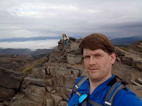
As I neared the summit, I passed various descending hikers including a local peakbagging friend, Greg Slayden, who had only hiked the final section from Checkpoint 3. I reached the summit at 10:40 AM, only 2-1/2 hours after I began hiking. It was especially rewarding for me because my broken wrist did not have any difficulties along the route or final summit approach.
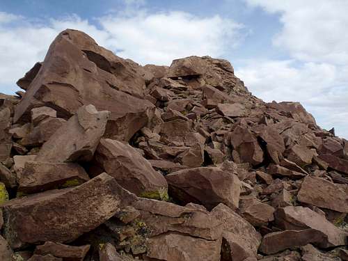
![9/11 Mount Grant Memorial Challenge]() Approaching Mount Grant Summit Hill...
Approaching Mount Grant Summit Hill...![9/11 Mount Grant Memorial Challenge]() Ascending Final Bouldery Slopes...
Ascending Final Bouldery Slopes...
Within a few minutes of arriving at the summit, as I signed the summit register, I heard someone approaching. Looking back at the route, I saw Ken Russell, another local peakbagging friend, making his final ascent to the summit area where I was sitting. After signing the register I left a new pen in it because the existing one was nearly dried-out. Ken and I shook hands as several other people, including Duane and Greg, reached the summit. Greg returned to the summit because Ken and Duane were two of his teammates and he was still close to the summit when they arrived. They would soon be joined by their other teammate (and another local peakbagging friend of mine), Bob Bolton, for another summit photo opportunity.
![9/11 Mount Grant Memorial Challenge]() Ken And I, Atop Mount Grant
Ken And I, Atop Mount Grant
I kept wondering where Mike was, because I knew he can be a fast hiker, but I figured his delay was probably due to waiting for an available motorized transport vehicle. After spending nearly 1-1/2 hours at the summit and surrounding area, and with thick clouds completely covering the mountaintop making visibility difficult, I decided to walk back to the FINISH line. As I neared the final road switchback prior to the FINISH line, I passed Mike ascending the road. He was determined to make the summit, despite the seemingly approaching storm. After having spent a long time there while wearing a t-shirt in breezy wind conditions, my body was getting a little chilled, hungry, and thirsty. Rather than head back down the mountain in one of the motorized transport vehicles, I waited at the FINISH line for Mike.
The weather greatly improved just prior to Mike reaching the summit. While he was enjoying his summit experience, I was back at the FINISH line enjoying some good conversations with multiple county highpointers. One of them came up to me and said, “Are you Craig?” I told him that was correct and he added, “I’m Ryan Courtney. I met some of your friends on Mount Lassen last week.” I knew immediately who he was talking about (Josh Lewis, EastKing, and BearQueen), and we talked for a few minutes about county highpoints. Now that he is living in Washington, again, he was interested in many of the county highpoints in our beloved state, and I told him I would give him advice for any of them if he so desired. Meeting Ryan confirmed that at least 12 people were at the event from Washington: Me, Mike, Bob, Duane, Ken, Greg, Ryan, Don Nelsen, and the Jones family (four people). What a way to represent our State!
During this timeframe, Mike arrived but Bob mysteriously disappeared. We (Mike, Greg, Ken, Duane, and I) soon realized that Bob must have taken motorized transport back down to the START line (parking lot) without telling any of us. The five of us had to wait for other vehicles to arrive, which was much later. During our descent, the driver stopped once to allow Mike to gather some “sacred water” from a spring and stopped one other time to allow us to see some bighorn sheep on a nearby ridgetop.
A ROSE AND CHURCH ARE FOUND BEYOND DAVIDSON
When we arrived at the parking lot, we discussed other hiking plans. Mike had made reservations at the “Atlantis” hotel near Reno, where coincidentally Bob, Duane, Ken, and Greg were also staying that evening. They considered making a summit attempt of Mount Davidson, the Storey County Highpoint located near Virginia City, while en route to Reno. They were OK with Mike and I joining them.
After deciding not to drive backroads to the mountain, we steeply ascended the southeast slopes to the summit. Mike led the way, ultimately reaching the summit well before any of us. Some of us joked how his “sacred water” must have given him super-strength. The ascent did not take very long, but the ground was very loose in various areas.
![Mount Davidson]() Mount Davidson
Mount Davidson![Mount Davidson]() Ken, Bob, And Duane Begin Ascending Mount Davidson...
Ken, Bob, And Duane Begin Ascending Mount Davidson...![Mount Davidson]() Mike On The Upper Slopes Of Mount Davidson...
Mike On The Upper Slopes Of Mount Davidson...
We met a man (who I now refer to as "All American Eric") at the summit who was trying to raise an American flag onto the summit flagpole, in honor of the 10th anniversary of the 9/11 tragedy. Greg helped him with the flag. After spending some time at the summit enjoying views and having good socialization, we began our descent. Rather than descend the steep, loose slopes of the southeast ridge (which we had ascended), we opted to follow an old road north and then east back down to Virginia City. Once in town, we all walked along the side of the road back to our cars.
![Mount Davidson]() Greg Helps "All American Eric" With Raising The Flag
Greg Helps "All American Eric" With Raising The Flag![Mount Davidson]() Group Photo Atop Mount Davidson
Group Photo Atop Mount Davidson![Mount Davidson]() Descending Mount Davidson...
Descending Mount Davidson...
Mike and I then drove to our hotel in Reno, and the rest of the guys were in vehicles a short distance behind us. After Mike and I checked into our room, I called Ken to tell him where we were. It turned out that they checked-in within a few minutes after we had, and ended up in the next two rooms down the hall. However, after having dinner together we said our “good-byes” as Mike and I had different plans for the following day.
The next day, September 12 (Monday), Mike and I woke up early and checked-out of the hotel by 5:30 AM. I had planned for us to attempt nearby Mount Rose, the Washoe County Highpoint. We reached the Mount Rose Trailhead at 6:25 AM, and we began hiking by 6:45 AM. This was a very enjoyable trail, and quite scenic compared to the other previous hikes of the weekend. We reached the summit of Mount Rose at 8:55 AM. We each took photos and made phone calls, and I explored a nearby false summit that had a rock wind-shelter containing several small American flags.
![Mount Rose]() Mount Rose, As Seen Along The Trail
Mount Rose, As Seen Along The Trail![Mount Rose]() A Relay Station And A Waterfall
A Relay Station And A Waterfall![Mount Rose]() Final Slopes To Summit...
Final Slopes To Summit...![Mount Rose]() Mike And I At The Summit Of Mount Rose
Mike And I At The Summit Of Mount Rose![Mount Rose]() Great View From False Summit Of Mount Rose
Great View From False Summit Of Mount Rose![Mount Rose]() Mike Atop Mount Rose
Mike Atop Mount Rose
After leaving the summit of Mount Rose, I opted to take the 2/3-mile stroll along the ridgetop to neighboring Church Peak. With little prominence, it is actually more like a false summit of Mount Rose than another mountain, and normally I would not have wasted my time visiting it. However, due to its close proximity, the fact it is an officially-named summit, and having a seemingly easy (but rocky) traverse, I hiked to Church Peak. In addition, I was very interested in seeing the many large rock piles scattered atop the upper slopes, and I wondered who put them there. With no interest in the extra summit, Mike was originally going to wait for me but changed his mind when he realized the breezy wind would chill his body more if he was not moving. After reaching the summit of Church Peak, we quickly began our descent. We drove back to Reno for lunch, and then flew back to Washington later that day.
![Mount Rose]() A "Smiling" Rock Found On Mount Rose
A "Smiling" Rock Found On Mount Rose![Mount Rose]() Mount Rose, As Seen From Church Peak
Mount Rose, As Seen From Church Peak![Mount Rose]() Flowers Found Along Trail During Descent
Flowers Found Along Trail During Descent![Mount Rose]() More Flowers Found Along Trail During Descent
More Flowers Found Along Trail During DescentPOST-TRIP ANALYSIS
Overall, this was a great trip. Mike is a fantastic hiking partner, and I am very happy he was a part of this experience. The weather was good during each of our summit hikes, despite a questionable forecast each day. In fact, a major storm hit Boundary Peak and dumped 5" of snow on the peak during Saturday night, meer hours after we had been there in seemingly ideal weather and route conditions. How quickly things can change in the mountains!
Mike and I reached our top two goals, Boundary Peak and Mount Grant, but we achieved so much more. In total, we reached five named summits, including four county highpoints and one state highpoint. We also each met new peakbagging acquaintances who we will be in contact with in the future. We were able to share this trip not only with each other, but with other people, which will make this a lasting memory.
On a side-note, the
9/11 Mount Grant Memorial Challenge was a big success, and was surprisingly well-run for a first-time event that involved a lot of participants, planners, and volunteers. If such an event ever happens again in the future, it is likely in good hands. Special thanks is given to all of the people who helped make the event a great experience.


Comments
Post a Comment